青藏高原腹地各拉丹冬南北坡多年冻土考察初步结果
刘广岳1,2( ), 邹德富1, 杨斌3, 杜二计1,2, 周华云1,2, 肖瑶1, 赵林2,4(), 谭昌海3, 胡国杰1, 庞强强1, 王武1, 孙哲1,2, 朱小凡1, 殷秀峰1, 汪凌霄4, 李智斌4, 谢昌卫1
), 邹德富1, 杨斌3, 杜二计1,2, 周华云1,2, 肖瑶1, 赵林2,4(), 谭昌海3, 胡国杰1, 庞强强1, 王武1, 孙哲1,2, 朱小凡1, 殷秀峰1, 汪凌霄4, 李智斌4, 谢昌卫1
Preliminary results of permafrost investigation on northern and southern slopes of Mt. Geladandong, interior Qinghai-Tibet Plateau
Guangyue LIU1,2(), Defu ZOU1, Bin YANG3, Erji DU1,2, Huayun ZHOU1,2, Yao XIAO1, Lin ZHAO2,4(), Changhai TAN3, Guojie HU1, Qiangqiang PANG1, Wu WANG1, Zhe SUN1,2, Xiaofan ZHU1, Xiufeng YIN1, Lingxiao WANG4, Zhibin LI4, Changwei XIE1
), Defu ZOU1, Bin YANG3, Erji DU1,2, Huayun ZHOU1,2, Yao XIAO1, Lin ZHAO2,4(), Changhai TAN3, Guojie HU1, Qiangqiang PANG1, Wu WANG1, Zhe SUN1,2, Xiaofan ZHU1, Xiufeng YIN1, Lingxiao WANG4, Zhibin LI4, Changwei XIE1
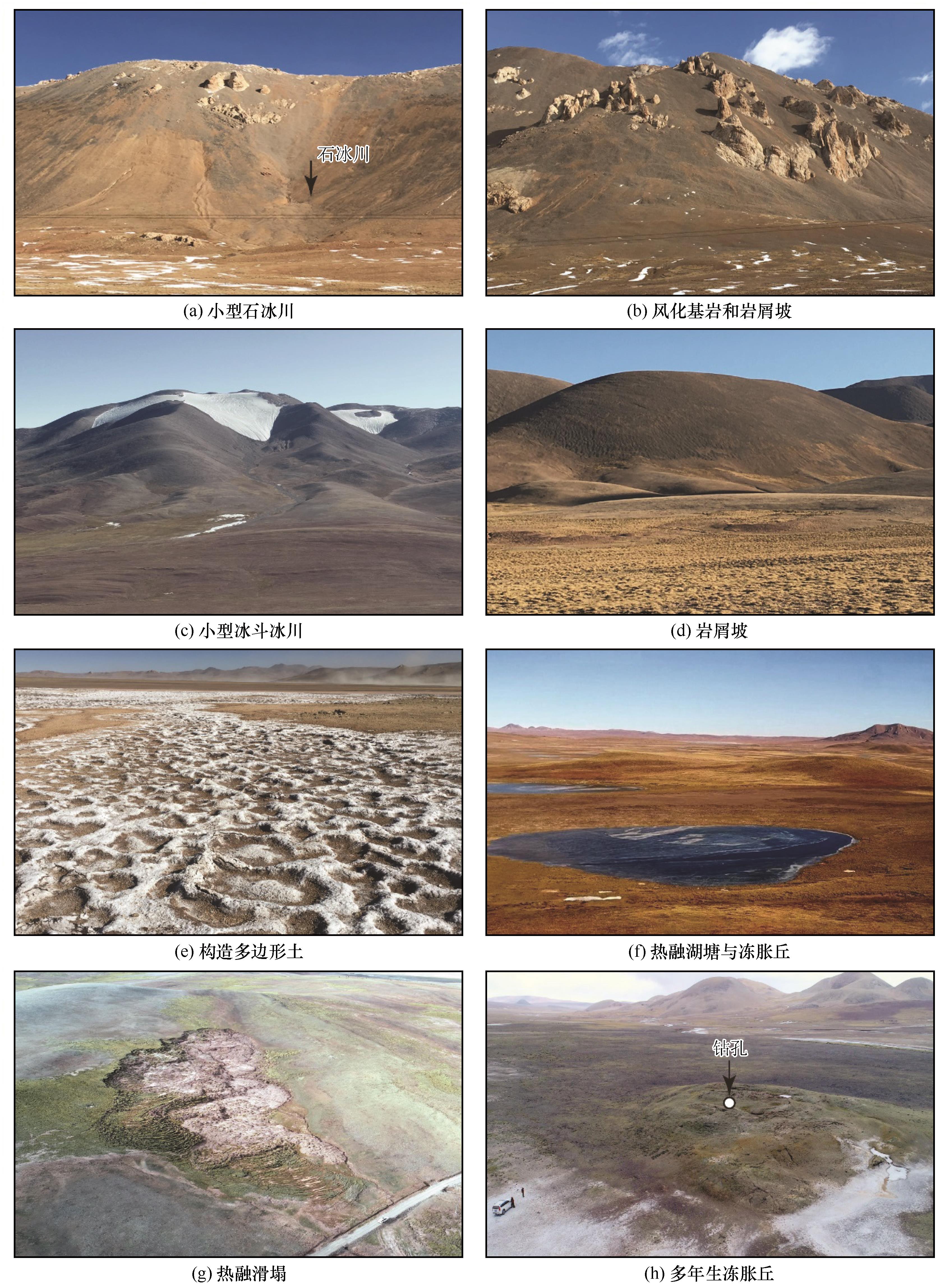
图3. 扎加藏布源区和沱沱河源区的典型冰缘地貌
Fig. 3. Several kinds of typical periglacial landforms discovered in source area of the Zhaga Zangbo River and source area of the Tuotuo River: a rock glacier (a), weathered bedrock and kurums (debris slope) (b), a small cirque glacier (c), debris slope (d), polygon soil (e), thermokast lakes and pingos (f), retrogressive thaw slump (g) and a perennial pingo (h) (The photos were taken on November 10, 2020, and the white dot marks the location of borehole dilled at the top of pingo)