3
2010
... 冰川运动是冰川的基本特征之一, 也是冰川区别于其他自然冰体的重要标志[1 -4 ] .冰川通过运动将积累区获得的物质输送到消融区, 维持着冰川的动态平衡[1 -2 ] .冰川运动与冰川长度、 面积、 物质平衡、 厚度以及几何形态的变化息息相关[5 -6 ] , 是认识冰川性质、 冰川变化的关键因素[7 ] , 也是冰川动力学与演化模型必不可少的参数之一[8 ] .近些年, 在气候变暖的大背景下, 冰川消融强烈[9 -13 ] , 导致动力系统的不稳定性加剧, 冰川灾害发生的频率升高[14 -15 ] .冰川运动的监测可以为冰川跃动、 冰崩等灾害事件的预警以及气候变化研究提供重要依据[14 -21 ] .冰川运动的研究具有重要的意义. ...
... [1 -2 ].冰川运动与冰川长度、 面积、 物质平衡、 厚度以及几何形态的变化息息相关[5 -6 ] , 是认识冰川性质、 冰川变化的关键因素[7 ] , 也是冰川动力学与演化模型必不可少的参数之一[8 ] .近些年, 在气候变暖的大背景下, 冰川消融强烈[9 -13 ] , 导致动力系统的不稳定性加剧, 冰川灾害发生的频率升高[14 -15 ] .冰川运动的监测可以为冰川跃动、 冰崩等灾害事件的预警以及气候变化研究提供重要依据[14 -21 ] .冰川运动的研究具有重要的意义. ...
... 一般认为, 冰川速度的变化可以用重力驱动应力的变化来解释, 而重力驱动应力的变化在很大程度上是由冰厚的变化来控制[1 -4 ] .随着全球气候的变化, 冰川普遍存在减薄退缩趋势[9 ,11 ,13 ,58 ] .因此, 大部分冰川呈现减速现象[12 ,34 ] .然而, 也有学者认为, 气温的变暖以及降水的增加, 会使得冰川底部温度升高以及底部含水量增加, 进而导致冰川底部摩擦力减小, 从而促使运动速度加快[125 ] . ...
1
1988
... 冰川运动是冰川的基本特征之一, 也是冰川区别于其他自然冰体的重要标志[1 -4 ] .冰川通过运动将积累区获得的物质输送到消融区, 维持着冰川的动态平衡[1 -2 ] .冰川运动与冰川长度、 面积、 物质平衡、 厚度以及几何形态的变化息息相关[5 -6 ] , 是认识冰川性质、 冰川变化的关键因素[7 ] , 也是冰川动力学与演化模型必不可少的参数之一[8 ] .近些年, 在气候变暖的大背景下, 冰川消融强烈[9 -13 ] , 导致动力系统的不稳定性加剧, 冰川灾害发生的频率升高[14 -15 ] .冰川运动的监测可以为冰川跃动、 冰崩等灾害事件的预警以及气候变化研究提供重要依据[14 -21 ] .冰川运动的研究具有重要的意义. ...
2
2017
... 冰川运动是冰川的基本特征之一, 也是冰川区别于其他自然冰体的重要标志[1 -4 ] .冰川通过运动将积累区获得的物质输送到消融区, 维持着冰川的动态平衡[1 -2 ] .冰川运动与冰川长度、 面积、 物质平衡、 厚度以及几何形态的变化息息相关[5 -6 ] , 是认识冰川性质、 冰川变化的关键因素[7 ] , 也是冰川动力学与演化模型必不可少的参数之一[8 ] .近些年, 在气候变暖的大背景下, 冰川消融强烈[9 -13 ] , 导致动力系统的不稳定性加剧, 冰川灾害发生的频率升高[14 -15 ] .冰川运动的监测可以为冰川跃动、 冰崩等灾害事件的预警以及气候变化研究提供重要依据[14 -21 ] .冰川运动的研究具有重要的意义. ...
... 一般认为, 冰川速度的变化可以用重力驱动应力的变化来解释, 而重力驱动应力的变化在很大程度上是由冰厚的变化来控制[1 -4 ] .随着全球气候的变化, 冰川普遍存在减薄退缩趋势[9 ,11 ,13 ,58 ] .因此, 大部分冰川呈现减速现象[12 ,34 ] .然而, 也有学者认为, 气温的变暖以及降水的增加, 会使得冰川底部温度升高以及底部含水量增加, 进而导致冰川底部摩擦力减小, 从而促使运动速度加快[125 ] . ...
Progress in glacier variations in China and its sensitivity to climatic change during the past century
1
2009
... 冰川运动是冰川的基本特征之一, 也是冰川区别于其他自然冰体的重要标志[1 -4 ] .冰川通过运动将积累区获得的物质输送到消融区, 维持着冰川的动态平衡[1 -2 ] .冰川运动与冰川长度、 面积、 物质平衡、 厚度以及几何形态的变化息息相关[5 -6 ] , 是认识冰川性质、 冰川变化的关键因素[7 ] , 也是冰川动力学与演化模型必不可少的参数之一[8 ] .近些年, 在气候变暖的大背景下, 冰川消融强烈[9 -13 ] , 导致动力系统的不稳定性加剧, 冰川灾害发生的频率升高[14 -15 ] .冰川运动的监测可以为冰川跃动、 冰崩等灾害事件的预警以及气候变化研究提供重要依据[14 -21 ] .冰川运动的研究具有重要的意义. ...
近百年来中国冰川变化及其对气候变化的敏感性研究进展
1
2009
... 冰川运动是冰川的基本特征之一, 也是冰川区别于其他自然冰体的重要标志[1 -4 ] .冰川通过运动将积累区获得的物质输送到消融区, 维持着冰川的动态平衡[1 -2 ] .冰川运动与冰川长度、 面积、 物质平衡、 厚度以及几何形态的变化息息相关[5 -6 ] , 是认识冰川性质、 冰川变化的关键因素[7 ] , 也是冰川动力学与演化模型必不可少的参数之一[8 ] .近些年, 在气候变暖的大背景下, 冰川消融强烈[9 -13 ] , 导致动力系统的不稳定性加剧, 冰川灾害发生的频率升高[14 -15 ] .冰川运动的监测可以为冰川跃动、 冰崩等灾害事件的预警以及气候变化研究提供重要依据[14 -21 ] .冰川运动的研究具有重要的意义. ...
The glaciers climate change initiative: methods for creating glacier area, elevation change and velocity products
9
2015
... 冰川运动是冰川的基本特征之一, 也是冰川区别于其他自然冰体的重要标志[1 -4 ] .冰川通过运动将积累区获得的物质输送到消融区, 维持着冰川的动态平衡[1 -2 ] .冰川运动与冰川长度、 面积、 物质平衡、 厚度以及几何形态的变化息息相关[5 -6 ] , 是认识冰川性质、 冰川变化的关键因素[7 ] , 也是冰川动力学与演化模型必不可少的参数之一[8 ] .近些年, 在气候变暖的大背景下, 冰川消融强烈[9 -13 ] , 导致动力系统的不稳定性加剧, 冰川灾害发生的频率升高[14 -15 ] .冰川运动的监测可以为冰川跃动、 冰崩等灾害事件的预警以及气候变化研究提供重要依据[14 -21 ] .冰川运动的研究具有重要的意义. ...
... 早期冰川运动速度的获取方法主要是在冰川表面布设测杆进行实地观测.从20世纪70年代开始, 随着遥感技术的不断发展, 通过遥感数据获得高空间和时间分辨率冰川运动信息的方法得到了广泛的应用[6 ] .卫星遥感数据能够一次获取较大范围内(数百平方公里)的冰川运动速度, 但获取速度结果的分辨率因选用的数据而异, 一般在1~30 m[12 ,22 -25 ] .近年来, 基于无人机和地基合成孔径雷达的冰川运动速度提取也逐渐得到学者们的关注.其中, 无人机能够获得小范围内(数平方公里)厘米级分辨率的冰川运动信息[26 -27 ] , 地基合成孔径雷达更是能够获得更高分辨率(毫米级)的形变信息[28 -33 ] .大量的研究显示, 冰川运动速度在空间上差异较大, 海洋型冰川的运动速度整体上大于大陆型冰川, 规模较大的冰川运动速度快于小冰川[12 ,34 ] .冰川运动速度在时间上的变化特征也存在较大差异, 近年来, 全球大部分地区冰川持续减速, 然而部分地区的冰川运动速度却略有加快[34 ] .部分学者认为冰川的运动速度主要受冰川的重力驱动, 冰川运动速度的变化主要是由冰川厚度的改变带来的[12 ,34 ] . ...
... 影像互相关(Cross-Correlation)和偏移量跟踪(Offset-Tracking)是当前研究中分别基于光学或SAR数据自动化识别并跟踪两景影像之间冰川表面位移发生前后的相似特征提取冰川表面运动速度的方法, 其观测精度在理论上能够达到1/10个像素大小[6 ,34 ,75 ] , 现已逐渐成为基于遥感数据冰川运动速度研究的主要手段.光学影像互相关和SAR偏移量跟踪方法的原理基本一致, 其核心思想是: 先对包含冰川区的两景影像进行常规的精确配准; 然后在两景配准后的影像上选择合适大小的窗口, 通过设置合适的步长, 在一定大小的搜索区域内滑动窗口, 进行互相关计算, 找到窗口内相关系数最大的两个点, 即为冰川位移发生前后的同名点; 计算同名点之间的偏移量, 即可获得同名点之间的实际位移量; 重复以上步骤, 即可获得整个冰川区在影像成像时间内的位移[76 -77 ] (图1 ). ...
... 光学影像互相关和SAR偏移量跟踪在提取冰川表面运动速度中各有优势, 在当前研究中得到了广泛的应用[22 -23 ,79 -84 ] .其中, 光学影像互相关方法具有数据源广泛、 覆盖范围大、 受地形限制小等优势, 但受天气条件影响明显, 适合年间隔的冰川表面运动速度提取, 在降水季节特征明显的地区尤为适用, 因为在不同年份相近时间积累/消融条件相似, 相似的表面特征有助于识别冰川表面位移变化前后的同名点; SAR数据受天气影响较小, 但时间间隔过长时, 较大的表面差异会使影像对之间出现失相关而无法有效获得冰川表面位移, 因此, SAR数据适合提取月尺度或季节尺度的冰川表面位移[6 ,71 ] .光学影像互相关和SAR偏移量跟踪两种方法详细介绍如下. ...
... 影像互相关是从光学影像自动获取冰川位移的有效方法, 其方法较多, 主要包括NCC (Normalized Cross-Correlation operated in the spatial domain)、 CCF (Cross-Correlation operated in the Frequency domain)、 PC (Phase Correlation operated in the frequency domain)、 CCF-O (Cross-Correlation operated in the Frequency domain on Orientation images)、 PC-O (Phase Correlation operated in the frequency domain on Orientation images), 以及COSI-Corr (Co-registration of Optically Sensed Images and Correlation)软件包(ENVI环境下的可视化插件)中的相位相关算法[6 ,75 ,85 ] .依据工作空间的不同, 可将其分为在空间域进行互相关和在频率域进行互相关两类.空间域中进行互相关, 计算两景影像之间的相对位移是直接基于影像的像元值实现的, 而频率域中进行互相关, 计算两景影像之间的相对位移是将原始影像进行傅里叶变换后在频率域中互相关来实现的[75 ] .其中, 频率域中进行互相关, 具有计算结果较为准确、 受影像对比度影响小等优点, 在影像互相关时优先考虑, 但对噪声较为敏感, 较适用于质量较好的光学影像; 而空间域中进行互相关时, 对于同等质量的光学影像, 结果质量比在频率域互相关获得的结果质量差, 且当影像对比度较低时效果较差, 但较适合用于质量较差以及来源不同的影像[6 ,75 ] .此外, 定向图像在频率域中进行影像互相关, 可以避免Landsat 7影像条带对冰川运动速度提取的影响[71 ] .各方法工作空间、 原理及其优缺点如表2 所示.其中, COSI-Corr软件包[86 -87 ] 能够实现亚像元级别的配准和影像互相关, 估计冰川运动速度的精度较高, 且在阴影和积雪区域同样能够获得较好的结果[6 ,75 ,85 ] , 已经得到了广泛的使用[88 -91 ] . ...
... [6 ,75 ].此外, 定向图像在频率域中进行影像互相关, 可以避免Landsat 7影像条带对冰川运动速度提取的影响[71 ] .各方法工作空间、 原理及其优缺点如表2 所示.其中, COSI-Corr软件包[86 -87 ] 能够实现亚像元级别的配准和影像互相关, 估计冰川运动速度的精度较高, 且在阴影和积雪区域同样能够获得较好的结果[6 ,75 ,85 ] , 已经得到了广泛的使用[88 -91 ] . ...
... [6 ,75 ,85 ], 已经得到了广泛的使用[88 -91 ] . ...
... 光学影像互相关的主要算法及比较[6 ,75 ,85 ] ...
... Optical image cross-correlation algorithms: principle and comparison[6 ,75 ,85 ] ...
Progress of the research on glacier velocities in China
9
2010
... 冰川运动是冰川的基本特征之一, 也是冰川区别于其他自然冰体的重要标志[1 -4 ] .冰川通过运动将积累区获得的物质输送到消融区, 维持着冰川的动态平衡[1 -2 ] .冰川运动与冰川长度、 面积、 物质平衡、 厚度以及几何形态的变化息息相关[5 -6 ] , 是认识冰川性质、 冰川变化的关键因素[7 ] , 也是冰川动力学与演化模型必不可少的参数之一[8 ] .近些年, 在气候变暖的大背景下, 冰川消融强烈[9 -13 ] , 导致动力系统的不稳定性加剧, 冰川灾害发生的频率升高[14 -15 ] .冰川运动的监测可以为冰川跃动、 冰崩等灾害事件的预警以及气候变化研究提供重要依据[14 -21 ] .冰川运动的研究具有重要的意义. ...
... Glaciers, of which the flow velocity had been measured, in the Tibetan Plateau and its surrounding areas
Table 1 地区 冰川名称 最早观测年份 或年代 文献来源 地区 冰川名称 最早观测年份 或年代 文献来源 天山 乌鲁木齐河源1号 1959 [35 -36 ] 喜马拉雅山 绒布 1950s [7 ,49 ] 奎屯河哈希勒根51号 1999 [37 -39 ] 枪勇 1970s [7 ] 青冰滩72号 2008 [40 -41 ] 念青唐古拉山 帕隆4号 2006 [7 ] 科其喀尔巴西 2009 [42 -43 ] 帕隆94号 2006 [7 ] 祁连山 老虎沟12号 1960s [44 -45 ] 贡嘎山 海螺沟 1981 [7 ,50 -51 ] 七一 1960s [46 ] 燕子沟 2009 [51 ] 羊龙河5号 1960s [7 ] 大/小贡巴 2009 [51 ] 水管河4号 1960s [7 ,47 ] 玉龙雪山 白水1号 2011 [52 -54 ] 宁缠河1号 2010 [47 -48 ] 喀喇昆仑山 巴托拉 1974 [55 -56 ]
实地观测获取冰川运动速度的方法能够最直接地获得精度较高的测量数据, 适合用于典型冰川的长期监测以及遥感反演结果的验证.然而, 受客观条件的限制, 测杆法难以对整个冰川表面进行观测, 且要耗费大量的人力物力, 难以大范围推广[7 ,40 ,47 -48 ,57 ] .此外, 在山地冰川上, 受极端气候以及地形等条件的限制, 大部分冰川难以进行测杆观测, 截至2015年, 全球范围内仅有约166条冰川开展了实地观测[58 ] . ...
... [
7 ]
青冰滩72号 2008 [40 -41 ] 念青唐古拉山 帕隆4号 2006 [7 ] 科其喀尔巴西 2009 [42 -43 ] 帕隆94号 2006 [7 ] 祁连山 老虎沟12号 1960s [44 -45 ] 贡嘎山 海螺沟 1981 [7 ,50 -51 ] 七一 1960s [46 ] 燕子沟 2009 [51 ] 羊龙河5号 1960s [7 ] 大/小贡巴 2009 [51 ] 水管河4号 1960s [7 ,47 ] 玉龙雪山 白水1号 2011 [52 -54 ] 宁缠河1号 2010 [47 -48 ] 喀喇昆仑山 巴托拉 1974 [55 -56 ] 实地观测获取冰川运动速度的方法能够最直接地获得精度较高的测量数据, 适合用于典型冰川的长期监测以及遥感反演结果的验证.然而, 受客观条件的限制, 测杆法难以对整个冰川表面进行观测, 且要耗费大量的人力物力, 难以大范围推广[7 ,40 ,47 -48 ,57 ] .此外, 在山地冰川上, 受极端气候以及地形等条件的限制, 大部分冰川难以进行测杆观测, 截至2015年, 全球范围内仅有约166条冰川开展了实地观测[58 ] . ...
... [
7 ]
科其喀尔巴西 2009 [42 -43 ] 帕隆94号 2006 [7 ] 祁连山 老虎沟12号 1960s [44 -45 ] 贡嘎山 海螺沟 1981 [7 ,50 -51 ] 七一 1960s [46 ] 燕子沟 2009 [51 ] 羊龙河5号 1960s [7 ] 大/小贡巴 2009 [51 ] 水管河4号 1960s [7 ,47 ] 玉龙雪山 白水1号 2011 [52 -54 ] 宁缠河1号 2010 [47 -48 ] 喀喇昆仑山 巴托拉 1974 [55 -56 ] 实地观测获取冰川运动速度的方法能够最直接地获得精度较高的测量数据, 适合用于典型冰川的长期监测以及遥感反演结果的验证.然而, 受客观条件的限制, 测杆法难以对整个冰川表面进行观测, 且要耗费大量的人力物力, 难以大范围推广[7 ,40 ,47 -48 ,57 ] .此外, 在山地冰川上, 受极端气候以及地形等条件的限制, 大部分冰川难以进行测杆观测, 截至2015年, 全球范围内仅有约166条冰川开展了实地观测[58 ] . ...
... [
7 ]
祁连山 老虎沟12号 1960s [44 -45 ] 贡嘎山 海螺沟 1981 [7 ,50 -51 ] 七一 1960s [46 ] 燕子沟 2009 [51 ] 羊龙河5号 1960s [7 ] 大/小贡巴 2009 [51 ] 水管河4号 1960s [7 ,47 ] 玉龙雪山 白水1号 2011 [52 -54 ] 宁缠河1号 2010 [47 -48 ] 喀喇昆仑山 巴托拉 1974 [55 -56 ] 实地观测获取冰川运动速度的方法能够最直接地获得精度较高的测量数据, 适合用于典型冰川的长期监测以及遥感反演结果的验证.然而, 受客观条件的限制, 测杆法难以对整个冰川表面进行观测, 且要耗费大量的人力物力, 难以大范围推广[7 ,40 ,47 -48 ,57 ] .此外, 在山地冰川上, 受极端气候以及地形等条件的限制, 大部分冰川难以进行测杆观测, 截至2015年, 全球范围内仅有约166条冰川开展了实地观测[58 ] . ...
... [
7 ,
50 -
51 ]
七一 1960s [46 ] 燕子沟 2009 [51 ] 羊龙河5号 1960s [7 ] 大/小贡巴 2009 [51 ] 水管河4号 1960s [7 ,47 ] 玉龙雪山 白水1号 2011 [52 -54 ] 宁缠河1号 2010 [47 -48 ] 喀喇昆仑山 巴托拉 1974 [55 -56 ] 实地观测获取冰川运动速度的方法能够最直接地获得精度较高的测量数据, 适合用于典型冰川的长期监测以及遥感反演结果的验证.然而, 受客观条件的限制, 测杆法难以对整个冰川表面进行观测, 且要耗费大量的人力物力, 难以大范围推广[7 ,40 ,47 -48 ,57 ] .此外, 在山地冰川上, 受极端气候以及地形等条件的限制, 大部分冰川难以进行测杆观测, 截至2015年, 全球范围内仅有约166条冰川开展了实地观测[58 ] . ...
... [
7 ]
大/小贡巴 2009 [51 ] 水管河4号 1960s [7 ,47 ] 玉龙雪山 白水1号 2011 [52 -54 ] 宁缠河1号 2010 [47 -48 ] 喀喇昆仑山 巴托拉 1974 [55 -56 ] 实地观测获取冰川运动速度的方法能够最直接地获得精度较高的测量数据, 适合用于典型冰川的长期监测以及遥感反演结果的验证.然而, 受客观条件的限制, 测杆法难以对整个冰川表面进行观测, 且要耗费大量的人力物力, 难以大范围推广[7 ,40 ,47 -48 ,57 ] .此外, 在山地冰川上, 受极端气候以及地形等条件的限制, 大部分冰川难以进行测杆观测, 截至2015年, 全球范围内仅有约166条冰川开展了实地观测[58 ] . ...
... [
7 ,
47 ]
玉龙雪山 白水1号 2011 [52 -54 ] 宁缠河1号 2010 [47 -48 ] 喀喇昆仑山 巴托拉 1974 [55 -56 ] 实地观测获取冰川运动速度的方法能够最直接地获得精度较高的测量数据, 适合用于典型冰川的长期监测以及遥感反演结果的验证.然而, 受客观条件的限制, 测杆法难以对整个冰川表面进行观测, 且要耗费大量的人力物力, 难以大范围推广[7 ,40 ,47 -48 ,57 ] .此外, 在山地冰川上, 受极端气候以及地形等条件的限制, 大部分冰川难以进行测杆观测, 截至2015年, 全球范围内仅有约166条冰川开展了实地观测[58 ] . ...
... 实地观测获取冰川运动速度的方法能够最直接地获得精度较高的测量数据, 适合用于典型冰川的长期监测以及遥感反演结果的验证.然而, 受客观条件的限制, 测杆法难以对整个冰川表面进行观测, 且要耗费大量的人力物力, 难以大范围推广[7 ,40 ,47 -48 ,57 ] .此外, 在山地冰川上, 受极端气候以及地形等条件的限制, 大部分冰川难以进行测杆观测, 截至2015年, 全球范围内仅有约166条冰川开展了实地观测[58 ] . ...
中国冰川运动速度研究进展
9
2010
... 冰川运动是冰川的基本特征之一, 也是冰川区别于其他自然冰体的重要标志[1 -4 ] .冰川通过运动将积累区获得的物质输送到消融区, 维持着冰川的动态平衡[1 -2 ] .冰川运动与冰川长度、 面积、 物质平衡、 厚度以及几何形态的变化息息相关[5 -6 ] , 是认识冰川性质、 冰川变化的关键因素[7 ] , 也是冰川动力学与演化模型必不可少的参数之一[8 ] .近些年, 在气候变暖的大背景下, 冰川消融强烈[9 -13 ] , 导致动力系统的不稳定性加剧, 冰川灾害发生的频率升高[14 -15 ] .冰川运动的监测可以为冰川跃动、 冰崩等灾害事件的预警以及气候变化研究提供重要依据[14 -21 ] .冰川运动的研究具有重要的意义. ...
... Glaciers, of which the flow velocity had been measured, in the Tibetan Plateau and its surrounding areas
Table 1 地区 冰川名称 最早观测年份 或年代 文献来源 地区 冰川名称 最早观测年份 或年代 文献来源 天山 乌鲁木齐河源1号 1959 [35 -36 ] 喜马拉雅山 绒布 1950s [7 ,49 ] 奎屯河哈希勒根51号 1999 [37 -39 ] 枪勇 1970s [7 ] 青冰滩72号 2008 [40 -41 ] 念青唐古拉山 帕隆4号 2006 [7 ] 科其喀尔巴西 2009 [42 -43 ] 帕隆94号 2006 [7 ] 祁连山 老虎沟12号 1960s [44 -45 ] 贡嘎山 海螺沟 1981 [7 ,50 -51 ] 七一 1960s [46 ] 燕子沟 2009 [51 ] 羊龙河5号 1960s [7 ] 大/小贡巴 2009 [51 ] 水管河4号 1960s [7 ,47 ] 玉龙雪山 白水1号 2011 [52 -54 ] 宁缠河1号 2010 [47 -48 ] 喀喇昆仑山 巴托拉 1974 [55 -56 ]
实地观测获取冰川运动速度的方法能够最直接地获得精度较高的测量数据, 适合用于典型冰川的长期监测以及遥感反演结果的验证.然而, 受客观条件的限制, 测杆法难以对整个冰川表面进行观测, 且要耗费大量的人力物力, 难以大范围推广[7 ,40 ,47 -48 ,57 ] .此外, 在山地冰川上, 受极端气候以及地形等条件的限制, 大部分冰川难以进行测杆观测, 截至2015年, 全球范围内仅有约166条冰川开展了实地观测[58 ] . ...
... [
7 ]
青冰滩72号 2008 [40 -41 ] 念青唐古拉山 帕隆4号 2006 [7 ] 科其喀尔巴西 2009 [42 -43 ] 帕隆94号 2006 [7 ] 祁连山 老虎沟12号 1960s [44 -45 ] 贡嘎山 海螺沟 1981 [7 ,50 -51 ] 七一 1960s [46 ] 燕子沟 2009 [51 ] 羊龙河5号 1960s [7 ] 大/小贡巴 2009 [51 ] 水管河4号 1960s [7 ,47 ] 玉龙雪山 白水1号 2011 [52 -54 ] 宁缠河1号 2010 [47 -48 ] 喀喇昆仑山 巴托拉 1974 [55 -56 ] 实地观测获取冰川运动速度的方法能够最直接地获得精度较高的测量数据, 适合用于典型冰川的长期监测以及遥感反演结果的验证.然而, 受客观条件的限制, 测杆法难以对整个冰川表面进行观测, 且要耗费大量的人力物力, 难以大范围推广[7 ,40 ,47 -48 ,57 ] .此外, 在山地冰川上, 受极端气候以及地形等条件的限制, 大部分冰川难以进行测杆观测, 截至2015年, 全球范围内仅有约166条冰川开展了实地观测[58 ] . ...
... [
7 ]
科其喀尔巴西 2009 [42 -43 ] 帕隆94号 2006 [7 ] 祁连山 老虎沟12号 1960s [44 -45 ] 贡嘎山 海螺沟 1981 [7 ,50 -51 ] 七一 1960s [46 ] 燕子沟 2009 [51 ] 羊龙河5号 1960s [7 ] 大/小贡巴 2009 [51 ] 水管河4号 1960s [7 ,47 ] 玉龙雪山 白水1号 2011 [52 -54 ] 宁缠河1号 2010 [47 -48 ] 喀喇昆仑山 巴托拉 1974 [55 -56 ] 实地观测获取冰川运动速度的方法能够最直接地获得精度较高的测量数据, 适合用于典型冰川的长期监测以及遥感反演结果的验证.然而, 受客观条件的限制, 测杆法难以对整个冰川表面进行观测, 且要耗费大量的人力物力, 难以大范围推广[7 ,40 ,47 -48 ,57 ] .此外, 在山地冰川上, 受极端气候以及地形等条件的限制, 大部分冰川难以进行测杆观测, 截至2015年, 全球范围内仅有约166条冰川开展了实地观测[58 ] . ...
... [
7 ]
祁连山 老虎沟12号 1960s [44 -45 ] 贡嘎山 海螺沟 1981 [7 ,50 -51 ] 七一 1960s [46 ] 燕子沟 2009 [51 ] 羊龙河5号 1960s [7 ] 大/小贡巴 2009 [51 ] 水管河4号 1960s [7 ,47 ] 玉龙雪山 白水1号 2011 [52 -54 ] 宁缠河1号 2010 [47 -48 ] 喀喇昆仑山 巴托拉 1974 [55 -56 ] 实地观测获取冰川运动速度的方法能够最直接地获得精度较高的测量数据, 适合用于典型冰川的长期监测以及遥感反演结果的验证.然而, 受客观条件的限制, 测杆法难以对整个冰川表面进行观测, 且要耗费大量的人力物力, 难以大范围推广[7 ,40 ,47 -48 ,57 ] .此外, 在山地冰川上, 受极端气候以及地形等条件的限制, 大部分冰川难以进行测杆观测, 截至2015年, 全球范围内仅有约166条冰川开展了实地观测[58 ] . ...
... [
7 ,
50 -
51 ]
七一 1960s [46 ] 燕子沟 2009 [51 ] 羊龙河5号 1960s [7 ] 大/小贡巴 2009 [51 ] 水管河4号 1960s [7 ,47 ] 玉龙雪山 白水1号 2011 [52 -54 ] 宁缠河1号 2010 [47 -48 ] 喀喇昆仑山 巴托拉 1974 [55 -56 ] 实地观测获取冰川运动速度的方法能够最直接地获得精度较高的测量数据, 适合用于典型冰川的长期监测以及遥感反演结果的验证.然而, 受客观条件的限制, 测杆法难以对整个冰川表面进行观测, 且要耗费大量的人力物力, 难以大范围推广[7 ,40 ,47 -48 ,57 ] .此外, 在山地冰川上, 受极端气候以及地形等条件的限制, 大部分冰川难以进行测杆观测, 截至2015年, 全球范围内仅有约166条冰川开展了实地观测[58 ] . ...
... [
7 ]
大/小贡巴 2009 [51 ] 水管河4号 1960s [7 ,47 ] 玉龙雪山 白水1号 2011 [52 -54 ] 宁缠河1号 2010 [47 -48 ] 喀喇昆仑山 巴托拉 1974 [55 -56 ] 实地观测获取冰川运动速度的方法能够最直接地获得精度较高的测量数据, 适合用于典型冰川的长期监测以及遥感反演结果的验证.然而, 受客观条件的限制, 测杆法难以对整个冰川表面进行观测, 且要耗费大量的人力物力, 难以大范围推广[7 ,40 ,47 -48 ,57 ] .此外, 在山地冰川上, 受极端气候以及地形等条件的限制, 大部分冰川难以进行测杆观测, 截至2015年, 全球范围内仅有约166条冰川开展了实地观测[58 ] . ...
... [
7 ,
47 ]
玉龙雪山 白水1号 2011 [52 -54 ] 宁缠河1号 2010 [47 -48 ] 喀喇昆仑山 巴托拉 1974 [55 -56 ] 实地观测获取冰川运动速度的方法能够最直接地获得精度较高的测量数据, 适合用于典型冰川的长期监测以及遥感反演结果的验证.然而, 受客观条件的限制, 测杆法难以对整个冰川表面进行观测, 且要耗费大量的人力物力, 难以大范围推广[7 ,40 ,47 -48 ,57 ] .此外, 在山地冰川上, 受极端气候以及地形等条件的限制, 大部分冰川难以进行测杆观测, 截至2015年, 全球范围内仅有约166条冰川开展了实地观测[58 ] . ...
... 实地观测获取冰川运动速度的方法能够最直接地获得精度较高的测量数据, 适合用于典型冰川的长期监测以及遥感反演结果的验证.然而, 受客观条件的限制, 测杆法难以对整个冰川表面进行观测, 且要耗费大量的人力物力, 难以大范围推广[7 ,40 ,47 -48 ,57 ] .此外, 在山地冰川上, 受极端气候以及地形等条件的限制, 大部分冰川难以进行测杆观测, 截至2015年, 全球范围内仅有约166条冰川开展了实地观测[58 ] . ...
Glacier dynamic models and their applicability for the glaciers in China
1
2007
... 冰川运动是冰川的基本特征之一, 也是冰川区别于其他自然冰体的重要标志[1 -4 ] .冰川通过运动将积累区获得的物质输送到消融区, 维持着冰川的动态平衡[1 -2 ] .冰川运动与冰川长度、 面积、 物质平衡、 厚度以及几何形态的变化息息相关[5 -6 ] , 是认识冰川性质、 冰川变化的关键因素[7 ] , 也是冰川动力学与演化模型必不可少的参数之一[8 ] .近些年, 在气候变暖的大背景下, 冰川消融强烈[9 -13 ] , 导致动力系统的不稳定性加剧, 冰川灾害发生的频率升高[14 -15 ] .冰川运动的监测可以为冰川跃动、 冰崩等灾害事件的预警以及气候变化研究提供重要依据[14 -21 ] .冰川运动的研究具有重要的意义. ...
冰川动力学模式及其对中国冰川变化预测的适应性
1
2007
... 冰川运动是冰川的基本特征之一, 也是冰川区别于其他自然冰体的重要标志[1 -4 ] .冰川通过运动将积累区获得的物质输送到消融区, 维持着冰川的动态平衡[1 -2 ] .冰川运动与冰川长度、 面积、 物质平衡、 厚度以及几何形态的变化息息相关[5 -6 ] , 是认识冰川性质、 冰川变化的关键因素[7 ] , 也是冰川动力学与演化模型必不可少的参数之一[8 ] .近些年, 在气候变暖的大背景下, 冰川消融强烈[9 -13 ] , 导致动力系统的不稳定性加剧, 冰川灾害发生的频率升高[14 -15 ] .冰川运动的监测可以为冰川跃动、 冰崩等灾害事件的预警以及气候变化研究提供重要依据[14 -21 ] .冰川运动的研究具有重要的意义. ...
2
2013
... 冰川运动是冰川的基本特征之一, 也是冰川区别于其他自然冰体的重要标志[1 -4 ] .冰川通过运动将积累区获得的物质输送到消融区, 维持着冰川的动态平衡[1 -2 ] .冰川运动与冰川长度、 面积、 物质平衡、 厚度以及几何形态的变化息息相关[5 -6 ] , 是认识冰川性质、 冰川变化的关键因素[7 ] , 也是冰川动力学与演化模型必不可少的参数之一[8 ] .近些年, 在气候变暖的大背景下, 冰川消融强烈[9 -13 ] , 导致动力系统的不稳定性加剧, 冰川灾害发生的频率升高[14 -15 ] .冰川运动的监测可以为冰川跃动、 冰崩等灾害事件的预警以及气候变化研究提供重要依据[14 -21 ] .冰川运动的研究具有重要的意义. ...
... 一般认为, 冰川速度的变化可以用重力驱动应力的变化来解释, 而重力驱动应力的变化在很大程度上是由冰厚的变化来控制[1 -4 ] .随着全球气候的变化, 冰川普遍存在减薄退缩趋势[9 ,11 ,13 ,58 ] .因此, 大部分冰川呈现减速现象[12 ,34 ] .然而, 也有学者认为, 气温的变暖以及降水的增加, 会使得冰川底部温度升高以及底部含水量增加, 进而导致冰川底部摩擦力减小, 从而促使运动速度加快[125 ] . ...
The state and fate of Himalayan glaciers
0
2012
Different glacier status with atmospheric circulations in Tibetan Plateau and surroundings
1
2012
... 一般认为, 冰川速度的变化可以用重力驱动应力的变化来解释, 而重力驱动应力的变化在很大程度上是由冰厚的变化来控制[1 -4 ] .随着全球气候的变化, 冰川普遍存在减薄退缩趋势[9 ,11 ,13 ,58 ] .因此, 大部分冰川呈现减速现象[12 ,34 ] .然而, 也有学者认为, 气温的变暖以及降水的增加, 会使得冰川底部温度升高以及底部含水量增加, 进而导致冰川底部摩擦力减小, 从而促使运动速度加快[125 ] . ...
Twenty-first century glacier slowdown driven by mass loss in High Mountain Asia
10
2018
... 早期冰川运动速度的获取方法主要是在冰川表面布设测杆进行实地观测.从20世纪70年代开始, 随着遥感技术的不断发展, 通过遥感数据获得高空间和时间分辨率冰川运动信息的方法得到了广泛的应用[6 ] .卫星遥感数据能够一次获取较大范围内(数百平方公里)的冰川运动速度, 但获取速度结果的分辨率因选用的数据而异, 一般在1~30 m[12 ,22 -25 ] .近年来, 基于无人机和地基合成孔径雷达的冰川运动速度提取也逐渐得到学者们的关注.其中, 无人机能够获得小范围内(数平方公里)厘米级分辨率的冰川运动信息[26 -27 ] , 地基合成孔径雷达更是能够获得更高分辨率(毫米级)的形变信息[28 -33 ] .大量的研究显示, 冰川运动速度在空间上差异较大, 海洋型冰川的运动速度整体上大于大陆型冰川, 规模较大的冰川运动速度快于小冰川[12 ,34 ] .冰川运动速度在时间上的变化特征也存在较大差异, 近年来, 全球大部分地区冰川持续减速, 然而部分地区的冰川运动速度却略有加快[34 ] .部分学者认为冰川的运动速度主要受冰川的重力驱动, 冰川运动速度的变化主要是由冰川厚度的改变带来的[12 ,34 ] . ...
... [12 ,34 ].冰川运动速度在时间上的变化特征也存在较大差异, 近年来, 全球大部分地区冰川持续减速, 然而部分地区的冰川运动速度却略有加快[34 ] .部分学者认为冰川的运动速度主要受冰川的重力驱动, 冰川运动速度的变化主要是由冰川厚度的改变带来的[12 ,34 ] . ...
... [12 ,34 ]. ...
... 其中, Landsat系列卫星影像是所有卫星遥感产品中时间跨度最长、 连续性最好的卫星遥感数据, 分辨率相对较高, 在冰川运动速度的提取以及时序分析中应用也最为广泛[12 ,34 ,92 -96 ] .对于光学影像互相关时使用的波段, 有学者认为Landsat系列影像的全色波段能够获得更高质量的速度结果[95 ,97 ] , 也有学者指出可见光中波长较长的红光和近红外波段受到大气散射的影响较小, 适合作为光学影像互相关的输入波段[98 -99 ] .Sam等[92 ] 对Landsat 8影像不同波段提取冰川运动速度的能力进行了对比, 并利用实测数据对提取结果进行了验证, 发现全色波段适合无表碛区域的冰川运动速度提取, 短波红外波段适合有表碛区域的冰川运动速度提取.因此, 具体使用哪个波段, 需结合实际情况进行选择.比如, 在研究大范围的冰川运动速度空间差异时, 应依据表碛的分布情况进行波段选择; 而在利用Landsat系列影像进行长时间序列的速度分析时, 应选取不同Landsat传感器均有的红光和近红外波段, 以避免冰川运动速度提取时因波段不同引起的差异. ...
... 一般认为, 冰川速度的变化可以用重力驱动应力的变化来解释, 而重力驱动应力的变化在很大程度上是由冰厚的变化来控制[1 -4 ] .随着全球气候的变化, 冰川普遍存在减薄退缩趋势[9 ,11 ,13 ,58 ] .因此, 大部分冰川呈现减速现象[12 ,34 ] .然而, 也有学者认为, 气温的变暖以及降水的增加, 会使得冰川底部温度升高以及底部含水量增加, 进而导致冰川底部摩擦力减小, 从而促使运动速度加快[125 ] . ...
... Dehecq等[12 ] 通过2000 - 2017年覆盖青藏高原及其周边地区的近百万景Landsat光学影像, 提取了青藏高原及其周边地区约94%的冰川表面运动年速度, 并研究了其变化特征(图3 ).2000 - 2017年多年运动速度的平均值显示: 海洋性气候控制地区冰川运动速度普遍较快, 念青唐古拉山冰川平均运动速度约为17.7 m·a-1 ; 亚大陆型冰川地区次之, 天山冰川平均运动速度约为15.6 m·a-1 ; 大陆性气候控制的高原内部冰川速度较慢, 平均运动速度约为8 m·a-1 .位于大陆性气候区的昆仑山(西部)和喀喇昆仑地区冰川平均运动速度较快, 可能主要是该区域冰川规模较大导致的.在11个区域中, 有9个区域的冰川显示出持续的减速, 其中, 念青唐古拉山和Spiti-Lahaul地区冰川减速最为剧烈, 每10年分别下降约(37.2±1.1)%和(34.3±4.5)%; 位于喜马拉雅地区的西尼泊尔(West Nepal)、 东尼泊尔(East Nepal)以及不丹地区冰川速度减慢也较为显著, 每10年分别下降约(21.0±2.3)%、 (17.0±1.0)%和(14.5±1.3)%; 兴都库什山、 帕米尔高原、 天山以及青藏高原内部地区冰川也呈现减速的趋势, 其中天山下降速度最小, 每10年约(6.4±1.0)%.相比之下, 昆仑山(西部)和喀喇昆仑地区冰川运动速度略有加快, 每10年分别增加约(4.0±2.1)%和(3.6±1.2)%.也有学者通过光学影像和SAR数据获得了青藏高原及其周边地区小区域内的冰川运动速度, 并对在空间和时间上的变化趋势进行了详细的讨论, 在天山[130 ] 、 喀喇昆仑山[93 ,116 ,127 ] 、 昆仑山[24 ,80 ,124 ] 、 喜马拉雅山[127 ,131 -132 ] 、 念青唐古拉山[133 ] 以及青藏高原内部的新青峰和马兰冰帽[134 ] 等地区均有涉及, 其结果与以上基本一致. ...
... [
12 ]
Mean flow velocity (A), variation of mean flow velocity (B) and percentage of mean flow velocity variation (C) in the Tibetan Plateau and its surrounding areas<sup>[<xref ref-type="bibr" rid="R12">12</xref>]</sup> Fig.3 ![]()
在冰川运动速度变化的影响因素上, Dehecq等[12 ] 与Heid等[34 ] 观点一致, 均认为冰川运动速度变化受冰川厚度变化控制.然而, 随着研究的不断深入, 学者们发现, 对于单个冰川系统来说, 冰川运动速度变化较为复杂, 受多种因素影响.Horgan等[125 ] 发现, 降雨会诱发大型入海冰川运动速度的加快; 但也有学者发现地表融化速度并不和冰川表面运动速度呈正相关, 当过多的融水进入冰内时, 融水会转换到冰下排水网络排出而不是停留在基底, 从而导致减速[98 ] .冰川积累区同一位置的冬季表面运动速度并不是总小于夏季, Usman等[116 ] 发现, 冬季会发生加速, 这类加速具有周期性, 通常为几年, 而且积累区冬季的加速也会造成下一个夏季速度的增大.另外, 跃动冰川和存在冰崩风险的冰川运动速度在时间和空间上变化较大, 其运动速度变化特征及其动力学过程也被越来越多的学者所关注[24 ,135 -138 ] . ...
... [
12 ]
Fig.3 ![]()
在冰川运动速度变化的影响因素上, Dehecq等[12 ] 与Heid等[34 ] 观点一致, 均认为冰川运动速度变化受冰川厚度变化控制.然而, 随着研究的不断深入, 学者们发现, 对于单个冰川系统来说, 冰川运动速度变化较为复杂, 受多种因素影响.Horgan等[125 ] 发现, 降雨会诱发大型入海冰川运动速度的加快; 但也有学者发现地表融化速度并不和冰川表面运动速度呈正相关, 当过多的融水进入冰内时, 融水会转换到冰下排水网络排出而不是停留在基底, 从而导致减速[98 ] .冰川积累区同一位置的冬季表面运动速度并不是总小于夏季, Usman等[116 ] 发现, 冬季会发生加速, 这类加速具有周期性, 通常为几年, 而且积累区冬季的加速也会造成下一个夏季速度的增大.另外, 跃动冰川和存在冰崩风险的冰川运动速度在时间和空间上变化较大, 其运动速度变化特征及其动力学过程也被越来越多的学者所关注[24 ,135 -138 ] . ...
... 在冰川运动速度变化的影响因素上, Dehecq等[12 ] 与Heid等[34 ] 观点一致, 均认为冰川运动速度变化受冰川厚度变化控制.然而, 随着研究的不断深入, 学者们发现, 对于单个冰川系统来说, 冰川运动速度变化较为复杂, 受多种因素影响.Horgan等[125 ] 发现, 降雨会诱发大型入海冰川运动速度的加快; 但也有学者发现地表融化速度并不和冰川表面运动速度呈正相关, 当过多的融水进入冰内时, 融水会转换到冰下排水网络排出而不是停留在基底, 从而导致减速[98 ] .冰川积累区同一位置的冬季表面运动速度并不是总小于夏季, Usman等[116 ] 发现, 冬季会发生加速, 这类加速具有周期性, 通常为几年, 而且积累区冬季的加速也会造成下一个夏季速度的增大.另外, 跃动冰川和存在冰崩风险的冰川运动速度在时间和空间上变化较大, 其运动速度变化特征及其动力学过程也被越来越多的学者所关注[24 ,135 -138 ] . ...
... 在数据源上, 遥感数据的丰富使得选取数据时有了更多的选择, 获取的数据也更有针对性, 无人机以及地基合成孔径雷达技术的不断成熟将会为冰川运动速度的研究提供高精度的数据支撑.在方法上, 物联网技术的应用可以实现冰川表面的气温、 降水、 位置等要素的实时远程监测; 随着计算机技术的发展, 基于地理大数据云计算平台提取冰川运动速度的方法逐渐进入人们视野, 出现了光学影像获得的、 基本覆盖全球冰川的GoLIVE、 ITS_LIVE等冰川运动速度开源产品, 有学者利用这一数据对冰川运动速度的时空分布特征进行了研究, 然而, 二者分辨率较粗, 且数据精度因用于互相关的影像而异, 使用时这些问题还需进一步考虑[12 ,134 ,139 -140 ] , 也有学者通过地理大数据云运算平台Google Earth Engine (GEE)对基于SAR数据的冰川运动速度提取进行了尝试[141 ] , 这一系列方法的使用将会极大地促进冰川运动速度研究; 此外, 随着冰川运动速度研究的不断成熟, 联合基于卫星、 航空器以及地面观测的协同、 多方位的速度研究已成必然.在研究内容上, 冰川运动速度变化的原因及其动力学过程将成为未来冰川学研究的热点.此外, 跃动冰川以及存在冰崩风险冰川的运动速度研究将备受关注. ...
Spatiotemporal pattern, trend, and influence of glacier change in Tibetan Plateau and surroundings under global warming
2
2019
... 冰川运动是冰川的基本特征之一, 也是冰川区别于其他自然冰体的重要标志[1 -4 ] .冰川通过运动将积累区获得的物质输送到消融区, 维持着冰川的动态平衡[1 -2 ] .冰川运动与冰川长度、 面积、 物质平衡、 厚度以及几何形态的变化息息相关[5 -6 ] , 是认识冰川性质、 冰川变化的关键因素[7 ] , 也是冰川动力学与演化模型必不可少的参数之一[8 ] .近些年, 在气候变暖的大背景下, 冰川消融强烈[9 -13 ] , 导致动力系统的不稳定性加剧, 冰川灾害发生的频率升高[14 -15 ] .冰川运动的监测可以为冰川跃动、 冰崩等灾害事件的预警以及气候变化研究提供重要依据[14 -21 ] .冰川运动的研究具有重要的意义. ...
... 一般认为, 冰川速度的变化可以用重力驱动应力的变化来解释, 而重力驱动应力的变化在很大程度上是由冰厚的变化来控制[1 -4 ] .随着全球气候的变化, 冰川普遍存在减薄退缩趋势[9 ,11 ,13 ,58 ] .因此, 大部分冰川呈现减速现象[12 ,34 ] .然而, 也有学者认为, 气温的变暖以及降水的增加, 会使得冰川底部温度升高以及底部含水量增加, 进而导致冰川底部摩擦力减小, 从而促使运动速度加快[125 ] . ...
全球变暖背景下青藏高原及周边地区冰川变化的时空格局与趋势及影响
2
2019
... 冰川运动是冰川的基本特征之一, 也是冰川区别于其他自然冰体的重要标志[1 -4 ] .冰川通过运动将积累区获得的物质输送到消融区, 维持着冰川的动态平衡[1 -2 ] .冰川运动与冰川长度、 面积、 物质平衡、 厚度以及几何形态的变化息息相关[5 -6 ] , 是认识冰川性质、 冰川变化的关键因素[7 ] , 也是冰川动力学与演化模型必不可少的参数之一[8 ] .近些年, 在气候变暖的大背景下, 冰川消融强烈[9 -13 ] , 导致动力系统的不稳定性加剧, 冰川灾害发生的频率升高[14 -15 ] .冰川运动的监测可以为冰川跃动、 冰崩等灾害事件的预警以及气候变化研究提供重要依据[14 -21 ] .冰川运动的研究具有重要的意义. ...
... 一般认为, 冰川速度的变化可以用重力驱动应力的变化来解释, 而重力驱动应力的变化在很大程度上是由冰厚的变化来控制[1 -4 ] .随着全球气候的变化, 冰川普遍存在减薄退缩趋势[9 ,11 ,13 ,58 ] .因此, 大部分冰川呈现减速现象[12 ,34 ] .然而, 也有学者认为, 气温的变暖以及降水的增加, 会使得冰川底部温度升高以及底部含水量增加, 进而导致冰川底部摩擦力减小, 从而促使运动速度加快[125 ] . ...
Glacial hazards on Tibetan Plateau and surrounding alpines
2
2019
... 冰川运动是冰川的基本特征之一, 也是冰川区别于其他自然冰体的重要标志[1 -4 ] .冰川通过运动将积累区获得的物质输送到消融区, 维持着冰川的动态平衡[1 -2 ] .冰川运动与冰川长度、 面积、 物质平衡、 厚度以及几何形态的变化息息相关[5 -6 ] , 是认识冰川性质、 冰川变化的关键因素[7 ] , 也是冰川动力学与演化模型必不可少的参数之一[8 ] .近些年, 在气候变暖的大背景下, 冰川消融强烈[9 -13 ] , 导致动力系统的不稳定性加剧, 冰川灾害发生的频率升高[14 -15 ] .冰川运动的监测可以为冰川跃动、 冰崩等灾害事件的预警以及气候变化研究提供重要依据[14 -21 ] .冰川运动的研究具有重要的意义. ...
... [14 -21 ].冰川运动的研究具有重要的意义. ...
青藏高原及周边地区的冰川灾害
2
2019
... 冰川运动是冰川的基本特征之一, 也是冰川区别于其他自然冰体的重要标志[1 -4 ] .冰川通过运动将积累区获得的物质输送到消融区, 维持着冰川的动态平衡[1 -2 ] .冰川运动与冰川长度、 面积、 物质平衡、 厚度以及几何形态的变化息息相关[5 -6 ] , 是认识冰川性质、 冰川变化的关键因素[7 ] , 也是冰川动力学与演化模型必不可少的参数之一[8 ] .近些年, 在气候变暖的大背景下, 冰川消融强烈[9 -13 ] , 导致动力系统的不稳定性加剧, 冰川灾害发生的频率升高[14 -15 ] .冰川运动的监测可以为冰川跃动、 冰崩等灾害事件的预警以及气候变化研究提供重要依据[14 -21 ] .冰川运动的研究具有重要的意义. ...
... [14 -21 ].冰川运动的研究具有重要的意义. ...
Glacier anomalies and relevant disaster risks on the Tibetan Plateau and surroundings
1
2019
... 冰川运动是冰川的基本特征之一, 也是冰川区别于其他自然冰体的重要标志[1 -4 ] .冰川通过运动将积累区获得的物质输送到消融区, 维持着冰川的动态平衡[1 -2 ] .冰川运动与冰川长度、 面积、 物质平衡、 厚度以及几何形态的变化息息相关[5 -6 ] , 是认识冰川性质、 冰川变化的关键因素[7 ] , 也是冰川动力学与演化模型必不可少的参数之一[8 ] .近些年, 在气候变暖的大背景下, 冰川消融强烈[9 -13 ] , 导致动力系统的不稳定性加剧, 冰川灾害发生的频率升高[14 -15 ] .冰川运动的监测可以为冰川跃动、 冰崩等灾害事件的预警以及气候变化研究提供重要依据[14 -21 ] .冰川运动的研究具有重要的意义. ...
青藏高原及周边地区近期冰川状态失常与灾变风险
1
2019
... 冰川运动是冰川的基本特征之一, 也是冰川区别于其他自然冰体的重要标志[1 -4 ] .冰川通过运动将积累区获得的物质输送到消融区, 维持着冰川的动态平衡[1 -2 ] .冰川运动与冰川长度、 面积、 物质平衡、 厚度以及几何形态的变化息息相关[5 -6 ] , 是认识冰川性质、 冰川变化的关键因素[7 ] , 也是冰川动力学与演化模型必不可少的参数之一[8 ] .近些年, 在气候变暖的大背景下, 冰川消融强烈[9 -13 ] , 导致动力系统的不稳定性加剧, 冰川灾害发生的频率升高[14 -15 ] .冰川运动的监测可以为冰川跃动、 冰崩等灾害事件的预警以及气候变化研究提供重要依据[14 -21 ] .冰川运动的研究具有重要的意义. ...
A rapid glacier surge on Mount Tobe Feng, western China, 2015
0
2016
Characterizing the May 2015 Karayaylak Glacier surge in the eastern Pamir Plateau using remote sensing
0
2016
Two glaciers collapse in western Tibet
0
2016
Characterization of Kyagar Glacier and lake outburst floods in 2018 based on time-series Sentinel-1A data
1
2020
... 用于SAR偏移量跟踪的数据主要包括欧洲航天局(ESA)ERS1/2[24 ] 、 ENVISAT-ASAR[80 ,24 ] 和Sentinel-1A/1B[19 ,25 ,113 -114 ] , 日本ALOS-PALSAR数据[83 ,115 -117 ] , 以及德国TerraSAR-X/TanDEM-X数据[118 -121 ] , 各数据源具体参数如表4 所示.此外, 基于国产SAR卫星数据的冰川运动速度研究也逐渐进入人们的视野[122 ] . ...
Advances in the study of glacier avalanches in High Asia
0
2018
Asian water tower change and its impacts
1
2019
... 冰川运动是冰川的基本特征之一, 也是冰川区别于其他自然冰体的重要标志[1 -4 ] .冰川通过运动将积累区获得的物质输送到消融区, 维持着冰川的动态平衡[1 -2 ] .冰川运动与冰川长度、 面积、 物质平衡、 厚度以及几何形态的变化息息相关[5 -6 ] , 是认识冰川性质、 冰川变化的关键因素[7 ] , 也是冰川动力学与演化模型必不可少的参数之一[8 ] .近些年, 在气候变暖的大背景下, 冰川消融强烈[9 -13 ] , 导致动力系统的不稳定性加剧, 冰川灾害发生的频率升高[14 -15 ] .冰川运动的监测可以为冰川跃动、 冰崩等灾害事件的预警以及气候变化研究提供重要依据[14 -21 ] .冰川运动的研究具有重要的意义. ...
“亚洲水塔”变化与影响
1
2019
... 冰川运动是冰川的基本特征之一, 也是冰川区别于其他自然冰体的重要标志[1 -4 ] .冰川通过运动将积累区获得的物质输送到消融区, 维持着冰川的动态平衡[1 -2 ] .冰川运动与冰川长度、 面积、 物质平衡、 厚度以及几何形态的变化息息相关[5 -6 ] , 是认识冰川性质、 冰川变化的关键因素[7 ] , 也是冰川动力学与演化模型必不可少的参数之一[8 ] .近些年, 在气候变暖的大背景下, 冰川消融强烈[9 -13 ] , 导致动力系统的不稳定性加剧, 冰川灾害发生的频率升高[14 -15 ] .冰川运动的监测可以为冰川跃动、 冰崩等灾害事件的预警以及气候变化研究提供重要依据[14 -21 ] .冰川运动的研究具有重要的意义. ...
Surface motion of mountain glaciers derived from satellite optical imagery
3
2005
... 早期冰川运动速度的获取方法主要是在冰川表面布设测杆进行实地观测.从20世纪70年代开始, 随着遥感技术的不断发展, 通过遥感数据获得高空间和时间分辨率冰川运动信息的方法得到了广泛的应用[6 ] .卫星遥感数据能够一次获取较大范围内(数百平方公里)的冰川运动速度, 但获取速度结果的分辨率因选用的数据而异, 一般在1~30 m[12 ,22 -25 ] .近年来, 基于无人机和地基合成孔径雷达的冰川运动速度提取也逐渐得到学者们的关注.其中, 无人机能够获得小范围内(数平方公里)厘米级分辨率的冰川运动信息[26 -27 ] , 地基合成孔径雷达更是能够获得更高分辨率(毫米级)的形变信息[28 -33 ] .大量的研究显示, 冰川运动速度在空间上差异较大, 海洋型冰川的运动速度整体上大于大陆型冰川, 规模较大的冰川运动速度快于小冰川[12 ,34 ] .冰川运动速度在时间上的变化特征也存在较大差异, 近年来, 全球大部分地区冰川持续减速, 然而部分地区的冰川运动速度却略有加快[34 ] .部分学者认为冰川的运动速度主要受冰川的重力驱动, 冰川运动速度的变化主要是由冰川厚度的改变带来的[12 ,34 ] . ...
... 光学影像互相关和SAR偏移量跟踪在提取冰川表面运动速度中各有优势, 在当前研究中得到了广泛的应用[22 -23 ,79 -84 ] .其中, 光学影像互相关方法具有数据源广泛、 覆盖范围大、 受地形限制小等优势, 但受天气条件影响明显, 适合年间隔的冰川表面运动速度提取, 在降水季节特征明显的地区尤为适用, 因为在不同年份相近时间积累/消融条件相似, 相似的表面特征有助于识别冰川表面位移变化前后的同名点; SAR数据受天气影响较小, 但时间间隔过长时, 较大的表面差异会使影像对之间出现失相关而无法有效获得冰川表面位移, 因此, SAR数据适合提取月尺度或季节尺度的冰川表面位移[6 ,71 ] .光学影像互相关和SAR偏移量跟踪两种方法详细介绍如下. ...
... 用于光学影像互相关的数据较多, 主要包括中分辨率的美国国家航空航天局(NASA)Landsat系列卫星影像、 美国国家航空航天局与日本通产省(METI)合作的ASTER卫星影像[42 ,79 ] , 以及高分辨率的法国国家空间研究中心(CNES)SPOT[22 ] 、 Pléiades[23 ] 等卫星影像.各数据源详细信息如表3 所示. ...
First surface velocity maps for glaciers of Monte Tronador, North Patagonian Andes, derived from sequential Pléiades satellite images
4
2015
... 光学影像互相关和SAR偏移量跟踪在提取冰川表面运动速度中各有优势, 在当前研究中得到了广泛的应用[22 -23 ,79 -84 ] .其中, 光学影像互相关方法具有数据源广泛、 覆盖范围大、 受地形限制小等优势, 但受天气条件影响明显, 适合年间隔的冰川表面运动速度提取, 在降水季节特征明显的地区尤为适用, 因为在不同年份相近时间积累/消融条件相似, 相似的表面特征有助于识别冰川表面位移变化前后的同名点; SAR数据受天气影响较小, 但时间间隔过长时, 较大的表面差异会使影像对之间出现失相关而无法有效获得冰川表面位移, 因此, SAR数据适合提取月尺度或季节尺度的冰川表面位移[6 ,71 ] .光学影像互相关和SAR偏移量跟踪两种方法详细介绍如下. ...
... 用于光学影像互相关的数据较多, 主要包括中分辨率的美国国家航空航天局(NASA)Landsat系列卫星影像、 美国国家航空航天局与日本通产省(METI)合作的ASTER卫星影像[42 ,79 ] , 以及高分辨率的法国国家空间研究中心(CNES)SPOT[22 ] 、 Pléiades[23 ] 等卫星影像.各数据源详细信息如表3 所示. ...
... 由于多种原因, 基于卫星遥感数据自动化提取的冰川运动速度结果中仍然会存在一些明显的误差, 需要对其进行过滤, 从而获得准确的冰川运动速度.不同研究处理误差的方法基本一致, 均包括相干性/信噪比滤波、 坡向滤波以及异常大值的去除等几个步骤.首先, 冰川运动速度提取时, 雷达差分干涉测量和SAR偏移量跟踪中的相干性以及光学影像互相关中的信噪比越低, 获得的位移越不可靠, 是减小冰川运动速度提取误差的重要依据.其次, 在理论上, 冰川实际位移方向在水平面上的投影与坡向的夹角不会大于90°, Ruiz等[23 ] 认为, 去除夹角大于60°的部分不仅能有效去除阴影、 雪崩、 冰塔的倾斜和倒下的影响, 还能减小由相关性较差以及透射投影造成的误差.此外, 相干性/信噪比和坡向滤波后的位移结果中, 都存在一些由于刃脊和角峰岩体崩落造成的个别孤立的大值, 为了不影响冰川表面位移场模型的构建, 需将其去除.有学者认为, 获得的冰川位移结果在统计学上的离群值即为冰川位移结果中孤立的大值, 去除这些离群值即可有效减小这类误差[23 ,88 ] . ...
... [23 ,88 ]. ...
Dynamics of surge-type glaciers in West Kunlun Shan, Northwestern Tibet
4
2015
... 用于SAR偏移量跟踪的数据主要包括欧洲航天局(ESA)ERS1/2[24 ] 、 ENVISAT-ASAR[80 ,24 ] 和Sentinel-1A/1B[19 ,25 ,113 -114 ] , 日本ALOS-PALSAR数据[83 ,115 -117 ] , 以及德国TerraSAR-X/TanDEM-X数据[118 -121 ] , 各数据源具体参数如表4 所示.此外, 基于国产SAR卫星数据的冰川运动速度研究也逐渐进入人们的视野[122 ] . ...
... ,24 ]和Sentinel-1A/1B[19 ,25 ,113 -114 ] , 日本ALOS-PALSAR数据[83 ,115 -117 ] , 以及德国TerraSAR-X/TanDEM-X数据[118 -121 ] , 各数据源具体参数如表4 所示.此外, 基于国产SAR卫星数据的冰川运动速度研究也逐渐进入人们的视野[122 ] . ...
... Dehecq等[12 ] 通过2000 - 2017年覆盖青藏高原及其周边地区的近百万景Landsat光学影像, 提取了青藏高原及其周边地区约94%的冰川表面运动年速度, 并研究了其变化特征(图3 ).2000 - 2017年多年运动速度的平均值显示: 海洋性气候控制地区冰川运动速度普遍较快, 念青唐古拉山冰川平均运动速度约为17.7 m·a-1 ; 亚大陆型冰川地区次之, 天山冰川平均运动速度约为15.6 m·a-1 ; 大陆性气候控制的高原内部冰川速度较慢, 平均运动速度约为8 m·a-1 .位于大陆性气候区的昆仑山(西部)和喀喇昆仑地区冰川平均运动速度较快, 可能主要是该区域冰川规模较大导致的.在11个区域中, 有9个区域的冰川显示出持续的减速, 其中, 念青唐古拉山和Spiti-Lahaul地区冰川减速最为剧烈, 每10年分别下降约(37.2±1.1)%和(34.3±4.5)%; 位于喜马拉雅地区的西尼泊尔(West Nepal)、 东尼泊尔(East Nepal)以及不丹地区冰川速度减慢也较为显著, 每10年分别下降约(21.0±2.3)%、 (17.0±1.0)%和(14.5±1.3)%; 兴都库什山、 帕米尔高原、 天山以及青藏高原内部地区冰川也呈现减速的趋势, 其中天山下降速度最小, 每10年约(6.4±1.0)%.相比之下, 昆仑山(西部)和喀喇昆仑地区冰川运动速度略有加快, 每10年分别增加约(4.0±2.1)%和(3.6±1.2)%.也有学者通过光学影像和SAR数据获得了青藏高原及其周边地区小区域内的冰川运动速度, 并对在空间和时间上的变化趋势进行了详细的讨论, 在天山[130 ] 、 喀喇昆仑山[93 ,116 ,127 ] 、 昆仑山[24 ,80 ,124 ] 、 喜马拉雅山[127 ,131 -132 ] 、 念青唐古拉山[133 ] 以及青藏高原内部的新青峰和马兰冰帽[134 ] 等地区均有涉及, 其结果与以上基本一致. ...
... 在冰川运动速度变化的影响因素上, Dehecq等[12 ] 与Heid等[34 ] 观点一致, 均认为冰川运动速度变化受冰川厚度变化控制.然而, 随着研究的不断深入, 学者们发现, 对于单个冰川系统来说, 冰川运动速度变化较为复杂, 受多种因素影响.Horgan等[125 ] 发现, 降雨会诱发大型入海冰川运动速度的加快; 但也有学者发现地表融化速度并不和冰川表面运动速度呈正相关, 当过多的融水进入冰内时, 融水会转换到冰下排水网络排出而不是停留在基底, 从而导致减速[98 ] .冰川积累区同一位置的冬季表面运动速度并不是总小于夏季, Usman等[116 ] 发现, 冬季会发生加速, 这类加速具有周期性, 通常为几年, 而且积累区冬季的加速也会造成下一个夏季速度的增大.另外, 跃动冰川和存在冰崩风险的冰川运动速度在时间和空间上变化较大, 其运动速度变化特征及其动力学过程也被越来越多的学者所关注[24 ,135 -138 ] . ...
Exploiting Sentinel-1 amplitude data for glacier surface velocity field measurements: feasibility demonstration on Baltoro Glacier
2
2016
... 早期冰川运动速度的获取方法主要是在冰川表面布设测杆进行实地观测.从20世纪70年代开始, 随着遥感技术的不断发展, 通过遥感数据获得高空间和时间分辨率冰川运动信息的方法得到了广泛的应用[6 ] .卫星遥感数据能够一次获取较大范围内(数百平方公里)的冰川运动速度, 但获取速度结果的分辨率因选用的数据而异, 一般在1~30 m[12 ,22 -25 ] .近年来, 基于无人机和地基合成孔径雷达的冰川运动速度提取也逐渐得到学者们的关注.其中, 无人机能够获得小范围内(数平方公里)厘米级分辨率的冰川运动信息[26 -27 ] , 地基合成孔径雷达更是能够获得更高分辨率(毫米级)的形变信息[28 -33 ] .大量的研究显示, 冰川运动速度在空间上差异较大, 海洋型冰川的运动速度整体上大于大陆型冰川, 规模较大的冰川运动速度快于小冰川[12 ,34 ] .冰川运动速度在时间上的变化特征也存在较大差异, 近年来, 全球大部分地区冰川持续减速, 然而部分地区的冰川运动速度却略有加快[34 ] .部分学者认为冰川的运动速度主要受冰川的重力驱动, 冰川运动速度的变化主要是由冰川厚度的改变带来的[12 ,34 ] . ...
... 用于SAR偏移量跟踪的数据主要包括欧洲航天局(ESA)ERS1/2[24 ] 、 ENVISAT-ASAR[80 ,24 ] 和Sentinel-1A/1B[19 ,25 ,113 -114 ] , 日本ALOS-PALSAR数据[83 ,115 -117 ] , 以及德国TerraSAR-X/TanDEM-X数据[118 -121 ] , 各数据源具体参数如表4 所示.此外, 基于国产SAR卫星数据的冰川运动速度研究也逐渐进入人们的视野[122 ] . ...
Seasonal surface velocities of a Himalayan glacier derived by automated correlation of unmanned aerial vehicle imagery
2
2016
... 早期冰川运动速度的获取方法主要是在冰川表面布设测杆进行实地观测.从20世纪70年代开始, 随着遥感技术的不断发展, 通过遥感数据获得高空间和时间分辨率冰川运动信息的方法得到了广泛的应用[6 ] .卫星遥感数据能够一次获取较大范围内(数百平方公里)的冰川运动速度, 但获取速度结果的分辨率因选用的数据而异, 一般在1~30 m[12 ,22 -25 ] .近年来, 基于无人机和地基合成孔径雷达的冰川运动速度提取也逐渐得到学者们的关注.其中, 无人机能够获得小范围内(数平方公里)厘米级分辨率的冰川运动信息[26 -27 ] , 地基合成孔径雷达更是能够获得更高分辨率(毫米级)的形变信息[28 -33 ] .大量的研究显示, 冰川运动速度在空间上差异较大, 海洋型冰川的运动速度整体上大于大陆型冰川, 规模较大的冰川运动速度快于小冰川[12 ,34 ] .冰川运动速度在时间上的变化特征也存在较大差异, 近年来, 全球大部分地区冰川持续减速, 然而部分地区的冰川运动速度却略有加快[34 ] .部分学者认为冰川的运动速度主要受冰川的重力驱动, 冰川运动速度的变化主要是由冰川厚度的改变带来的[12 ,34 ] . ...
... 无人机具有方便携带运输、 无场地要求、 受天气影响小、 机动灵活、 分辨率高等优势.近年来, 无人机技术不断成熟, 其高分辨率的正射影像(DOM)和数字表面模型(DSM)数据使得获取高时空分辨率的冰川变化详细信息成为可能, 为现代冰川变化研究提供了新的见解[100 -111 ] .Kraaijenbrink等[26 ] 利用三次无人机测绘获得的DOM数据反演了尼泊尔Lirung冰川末端的表面运动速度, 发现在合适的窗口尺寸下, 基于影像互相关的方法能够从DOM数据中有效提取冰川位移.Rossini等[27 ] 利用2016年7月和9月两次无人机任务获得的DOM和DSM数据, 通过影像互相关的方法获得了Morteratsch冰川消融区的运动速度, 并通过对不同方法的比较验证了结果的准确性, 认为无人机摄影测量可以在厘米级的空间分辨率下对冰川的复杂演化进行定性和定量评估.然而, 现有基于无人机的冰川运动速度研究相对较少.此外, 鉴于冰川区的巨大地形高差, 无人机大多只能作业于冰川末端, 难以覆盖整个冰川区. ...
Rapid melting dynamics of an alpine glacier with repeated UAV photogrammetry
2
2018
... 早期冰川运动速度的获取方法主要是在冰川表面布设测杆进行实地观测.从20世纪70年代开始, 随着遥感技术的不断发展, 通过遥感数据获得高空间和时间分辨率冰川运动信息的方法得到了广泛的应用[6 ] .卫星遥感数据能够一次获取较大范围内(数百平方公里)的冰川运动速度, 但获取速度结果的分辨率因选用的数据而异, 一般在1~30 m[12 ,22 -25 ] .近年来, 基于无人机和地基合成孔径雷达的冰川运动速度提取也逐渐得到学者们的关注.其中, 无人机能够获得小范围内(数平方公里)厘米级分辨率的冰川运动信息[26 -27 ] , 地基合成孔径雷达更是能够获得更高分辨率(毫米级)的形变信息[28 -33 ] .大量的研究显示, 冰川运动速度在空间上差异较大, 海洋型冰川的运动速度整体上大于大陆型冰川, 规模较大的冰川运动速度快于小冰川[12 ,34 ] .冰川运动速度在时间上的变化特征也存在较大差异, 近年来, 全球大部分地区冰川持续减速, 然而部分地区的冰川运动速度却略有加快[34 ] .部分学者认为冰川的运动速度主要受冰川的重力驱动, 冰川运动速度的变化主要是由冰川厚度的改变带来的[12 ,34 ] . ...
... 无人机具有方便携带运输、 无场地要求、 受天气影响小、 机动灵活、 分辨率高等优势.近年来, 无人机技术不断成熟, 其高分辨率的正射影像(DOM)和数字表面模型(DSM)数据使得获取高时空分辨率的冰川变化详细信息成为可能, 为现代冰川变化研究提供了新的见解[100 -111 ] .Kraaijenbrink等[26 ] 利用三次无人机测绘获得的DOM数据反演了尼泊尔Lirung冰川末端的表面运动速度, 发现在合适的窗口尺寸下, 基于影像互相关的方法能够从DOM数据中有效提取冰川位移.Rossini等[27 ] 利用2016年7月和9月两次无人机任务获得的DOM和DSM数据, 通过影像互相关的方法获得了Morteratsch冰川消融区的运动速度, 并通过对不同方法的比较验证了结果的准确性, 认为无人机摄影测量可以在厘米级的空间分辨率下对冰川的复杂演化进行定性和定量评估.然而, 现有基于无人机的冰川运动速度研究相对较少.此外, 鉴于冰川区的巨大地形高差, 无人机大多只能作业于冰川末端, 难以覆盖整个冰川区. ...
Monitoring of Belvedere Glacier using a wide angle GB-SAR interferometer
3
2009
... 早期冰川运动速度的获取方法主要是在冰川表面布设测杆进行实地观测.从20世纪70年代开始, 随着遥感技术的不断发展, 通过遥感数据获得高空间和时间分辨率冰川运动信息的方法得到了广泛的应用[6 ] .卫星遥感数据能够一次获取较大范围内(数百平方公里)的冰川运动速度, 但获取速度结果的分辨率因选用的数据而异, 一般在1~30 m[12 ,22 -25 ] .近年来, 基于无人机和地基合成孔径雷达的冰川运动速度提取也逐渐得到学者们的关注.其中, 无人机能够获得小范围内(数平方公里)厘米级分辨率的冰川运动信息[26 -27 ] , 地基合成孔径雷达更是能够获得更高分辨率(毫米级)的形变信息[28 -33 ] .大量的研究显示, 冰川运动速度在空间上差异较大, 海洋型冰川的运动速度整体上大于大陆型冰川, 规模较大的冰川运动速度快于小冰川[12 ,34 ] .冰川运动速度在时间上的变化特征也存在较大差异, 近年来, 全球大部分地区冰川持续减速, 然而部分地区的冰川运动速度却略有加快[34 ] .部分学者认为冰川的运动速度主要受冰川的重力驱动, 冰川运动速度的变化主要是由冰川厚度的改变带来的[12 ,34 ] . ...
... 地基合成孔径雷达是近十年来发展起来的一种由星载、 机载合成孔径雷达发展而来的地面遥感成像系统.它在国外发展较早, 主要应用在变形监测当中, 能够对研究目标进行全天时、 全天候、 毫米级别的形变监测, 监测距离长达数公里.在早期的研究中, 主要用于滑坡监测, 但近年来也被应用于冰川运动速度提取[28 -33 ] .Noferini等[28 ] 获得了西欧Belvedere冰川连续一个月每半小时的冰川形变图, 发现地基合成孔径雷达能够有效获得冰川形变.Han等[29 ] 通过地基合成孔径雷达对维多利亚地北部、 南极洲东部的Campbell冰川运动速度进行了观测, 11小时观测获得的差分干涉图显示, 冰川在雷达方向位移约为8 cm.Dematteis等[30 ] 使用地基合成孔径雷达对位于勃朗峰意大利一侧的Planpincieux冰川进行了长时间的观测, 发现地基合成孔径雷达能够有效获得冰川形变, 但在气象条件多变的情况下监测结果较差.此外, 过高的分辨率使得结果中包含了大量与冰川运动无关的形变信息(如冰面差异融化、 表碛移动等), 这些过多的细节特征反而会干扰冰川运动信息的提取. ...
... [28 ]获得了西欧Belvedere冰川连续一个月每半小时的冰川形变图, 发现地基合成孔径雷达能够有效获得冰川形变.Han等[29 ] 通过地基合成孔径雷达对维多利亚地北部、 南极洲东部的Campbell冰川运动速度进行了观测, 11小时观测获得的差分干涉图显示, 冰川在雷达方向位移约为8 cm.Dematteis等[30 ] 使用地基合成孔径雷达对位于勃朗峰意大利一侧的Planpincieux冰川进行了长时间的观测, 发现地基合成孔径雷达能够有效获得冰川形变, 但在气象条件多变的情况下监测结果较差.此外, 过高的分辨率使得结果中包含了大量与冰川运动无关的形变信息(如冰面差异融化、 表碛移动等), 这些过多的细节特征反而会干扰冰川运动信息的提取. ...
Motion of Campbell Glacier, East Antarctica, observed by satellite and ground-based interferometric synthetic aperture radar
1
... 地基合成孔径雷达是近十年来发展起来的一种由星载、 机载合成孔径雷达发展而来的地面遥感成像系统.它在国外发展较早, 主要应用在变形监测当中, 能够对研究目标进行全天时、 全天候、 毫米级别的形变监测, 监测距离长达数公里.在早期的研究中, 主要用于滑坡监测, 但近年来也被应用于冰川运动速度提取[28 -33 ] .Noferini等[28 ] 获得了西欧Belvedere冰川连续一个月每半小时的冰川形变图, 发现地基合成孔径雷达能够有效获得冰川形变.Han等[29 ] 通过地基合成孔径雷达对维多利亚地北部、 南极洲东部的Campbell冰川运动速度进行了观测, 11小时观测获得的差分干涉图显示, 冰川在雷达方向位移约为8 cm.Dematteis等[30 ] 使用地基合成孔径雷达对位于勃朗峰意大利一侧的Planpincieux冰川进行了长时间的观测, 发现地基合成孔径雷达能够有效获得冰川形变, 但在气象条件多变的情况下监测结果较差.此外, 过高的分辨率使得结果中包含了大量与冰川运动无关的形变信息(如冰面差异融化、 表碛移动等), 这些过多的细节特征反而会干扰冰川运动信息的提取. ...
Monitoring Alpine glacier surface deformations with GB-SAR
1
2017
... 地基合成孔径雷达是近十年来发展起来的一种由星载、 机载合成孔径雷达发展而来的地面遥感成像系统.它在国外发展较早, 主要应用在变形监测当中, 能够对研究目标进行全天时、 全天候、 毫米级别的形变监测, 监测距离长达数公里.在早期的研究中, 主要用于滑坡监测, 但近年来也被应用于冰川运动速度提取[28 -33 ] .Noferini等[28 ] 获得了西欧Belvedere冰川连续一个月每半小时的冰川形变图, 发现地基合成孔径雷达能够有效获得冰川形变.Han等[29 ] 通过地基合成孔径雷达对维多利亚地北部、 南极洲东部的Campbell冰川运动速度进行了观测, 11小时观测获得的差分干涉图显示, 冰川在雷达方向位移约为8 cm.Dematteis等[30 ] 使用地基合成孔径雷达对位于勃朗峰意大利一侧的Planpincieux冰川进行了长时间的观测, 发现地基合成孔径雷达能够有效获得冰川形变, 但在气象条件多变的情况下监测结果较差.此外, 过高的分辨率使得结果中包含了大量与冰川运动无关的形变信息(如冰面差异融化、 表碛移动等), 这些过多的细节特征反而会干扰冰川运动信息的提取. ...
The mountain glacier surface velocity monitoring by ground-based InSAR
0
2016
Measuring mountain glacier flow velocity by means of ground-based InSAR
0
Research status and prospects of GB-SAR deformation monitoring technology
2
... 早期冰川运动速度的获取方法主要是在冰川表面布设测杆进行实地观测.从20世纪70年代开始, 随着遥感技术的不断发展, 通过遥感数据获得高空间和时间分辨率冰川运动信息的方法得到了广泛的应用[6 ] .卫星遥感数据能够一次获取较大范围内(数百平方公里)的冰川运动速度, 但获取速度结果的分辨率因选用的数据而异, 一般在1~30 m[12 ,22 -25 ] .近年来, 基于无人机和地基合成孔径雷达的冰川运动速度提取也逐渐得到学者们的关注.其中, 无人机能够获得小范围内(数平方公里)厘米级分辨率的冰川运动信息[26 -27 ] , 地基合成孔径雷达更是能够获得更高分辨率(毫米级)的形变信息[28 -33 ] .大量的研究显示, 冰川运动速度在空间上差异较大, 海洋型冰川的运动速度整体上大于大陆型冰川, 规模较大的冰川运动速度快于小冰川[12 ,34 ] .冰川运动速度在时间上的变化特征也存在较大差异, 近年来, 全球大部分地区冰川持续减速, 然而部分地区的冰川运动速度却略有加快[34 ] .部分学者认为冰川的运动速度主要受冰川的重力驱动, 冰川运动速度的变化主要是由冰川厚度的改变带来的[12 ,34 ] . ...
... 地基合成孔径雷达是近十年来发展起来的一种由星载、 机载合成孔径雷达发展而来的地面遥感成像系统.它在国外发展较早, 主要应用在变形监测当中, 能够对研究目标进行全天时、 全天候、 毫米级别的形变监测, 监测距离长达数公里.在早期的研究中, 主要用于滑坡监测, 但近年来也被应用于冰川运动速度提取[28 -33 ] .Noferini等[28 ] 获得了西欧Belvedere冰川连续一个月每半小时的冰川形变图, 发现地基合成孔径雷达能够有效获得冰川形变.Han等[29 ] 通过地基合成孔径雷达对维多利亚地北部、 南极洲东部的Campbell冰川运动速度进行了观测, 11小时观测获得的差分干涉图显示, 冰川在雷达方向位移约为8 cm.Dematteis等[30 ] 使用地基合成孔径雷达对位于勃朗峰意大利一侧的Planpincieux冰川进行了长时间的观测, 发现地基合成孔径雷达能够有效获得冰川形变, 但在气象条件多变的情况下监测结果较差.此外, 过高的分辨率使得结果中包含了大量与冰川运动无关的形变信息(如冰面差异融化、 表碛移动等), 这些过多的细节特征反而会干扰冰川运动信息的提取. ...
GB-SAR变形监测技术研究现状与展望
2
2019
... 早期冰川运动速度的获取方法主要是在冰川表面布设测杆进行实地观测.从20世纪70年代开始, 随着遥感技术的不断发展, 通过遥感数据获得高空间和时间分辨率冰川运动信息的方法得到了广泛的应用[6 ] .卫星遥感数据能够一次获取较大范围内(数百平方公里)的冰川运动速度, 但获取速度结果的分辨率因选用的数据而异, 一般在1~30 m[12 ,22 -25 ] .近年来, 基于无人机和地基合成孔径雷达的冰川运动速度提取也逐渐得到学者们的关注.其中, 无人机能够获得小范围内(数平方公里)厘米级分辨率的冰川运动信息[26 -27 ] , 地基合成孔径雷达更是能够获得更高分辨率(毫米级)的形变信息[28 -33 ] .大量的研究显示, 冰川运动速度在空间上差异较大, 海洋型冰川的运动速度整体上大于大陆型冰川, 规模较大的冰川运动速度快于小冰川[12 ,34 ] .冰川运动速度在时间上的变化特征也存在较大差异, 近年来, 全球大部分地区冰川持续减速, 然而部分地区的冰川运动速度却略有加快[34 ] .部分学者认为冰川的运动速度主要受冰川的重力驱动, 冰川运动速度的变化主要是由冰川厚度的改变带来的[12 ,34 ] . ...
... 地基合成孔径雷达是近十年来发展起来的一种由星载、 机载合成孔径雷达发展而来的地面遥感成像系统.它在国外发展较早, 主要应用在变形监测当中, 能够对研究目标进行全天时、 全天候、 毫米级别的形变监测, 监测距离长达数公里.在早期的研究中, 主要用于滑坡监测, 但近年来也被应用于冰川运动速度提取[28 -33 ] .Noferini等[28 ] 获得了西欧Belvedere冰川连续一个月每半小时的冰川形变图, 发现地基合成孔径雷达能够有效获得冰川形变.Han等[29 ] 通过地基合成孔径雷达对维多利亚地北部、 南极洲东部的Campbell冰川运动速度进行了观测, 11小时观测获得的差分干涉图显示, 冰川在雷达方向位移约为8 cm.Dematteis等[30 ] 使用地基合成孔径雷达对位于勃朗峰意大利一侧的Planpincieux冰川进行了长时间的观测, 发现地基合成孔径雷达能够有效获得冰川形变, 但在气象条件多变的情况下监测结果较差.此外, 过高的分辨率使得结果中包含了大量与冰川运动无关的形变信息(如冰面差异融化、 表碛移动等), 这些过多的细节特征反而会干扰冰川运动信息的提取. ...
Repeat optical satellite images reveal widespread and long term decrease in land-terminating glacier speeds
11
2012
... 早期冰川运动速度的获取方法主要是在冰川表面布设测杆进行实地观测.从20世纪70年代开始, 随着遥感技术的不断发展, 通过遥感数据获得高空间和时间分辨率冰川运动信息的方法得到了广泛的应用[6 ] .卫星遥感数据能够一次获取较大范围内(数百平方公里)的冰川运动速度, 但获取速度结果的分辨率因选用的数据而异, 一般在1~30 m[12 ,22 -25 ] .近年来, 基于无人机和地基合成孔径雷达的冰川运动速度提取也逐渐得到学者们的关注.其中, 无人机能够获得小范围内(数平方公里)厘米级分辨率的冰川运动信息[26 -27 ] , 地基合成孔径雷达更是能够获得更高分辨率(毫米级)的形变信息[28 -33 ] .大量的研究显示, 冰川运动速度在空间上差异较大, 海洋型冰川的运动速度整体上大于大陆型冰川, 规模较大的冰川运动速度快于小冰川[12 ,34 ] .冰川运动速度在时间上的变化特征也存在较大差异, 近年来, 全球大部分地区冰川持续减速, 然而部分地区的冰川运动速度却略有加快[34 ] .部分学者认为冰川的运动速度主要受冰川的重力驱动, 冰川运动速度的变化主要是由冰川厚度的改变带来的[12 ,34 ] . ...
... [34 ].部分学者认为冰川的运动速度主要受冰川的重力驱动, 冰川运动速度的变化主要是由冰川厚度的改变带来的[12 ,34 ] . ...
... ,34 ]. ...
... 影像互相关(Cross-Correlation)和偏移量跟踪(Offset-Tracking)是当前研究中分别基于光学或SAR数据自动化识别并跟踪两景影像之间冰川表面位移发生前后的相似特征提取冰川表面运动速度的方法, 其观测精度在理论上能够达到1/10个像素大小[6 ,34 ,75 ] , 现已逐渐成为基于遥感数据冰川运动速度研究的主要手段.光学影像互相关和SAR偏移量跟踪方法的原理基本一致, 其核心思想是: 先对包含冰川区的两景影像进行常规的精确配准; 然后在两景配准后的影像上选择合适大小的窗口, 通过设置合适的步长, 在一定大小的搜索区域内滑动窗口, 进行互相关计算, 找到窗口内相关系数最大的两个点, 即为冰川位移发生前后的同名点; 计算同名点之间的偏移量, 即可获得同名点之间的实际位移量; 重复以上步骤, 即可获得整个冰川区在影像成像时间内的位移[76 -77 ] (图1 ). ...
... 其中, Landsat系列卫星影像是所有卫星遥感产品中时间跨度最长、 连续性最好的卫星遥感数据, 分辨率相对较高, 在冰川运动速度的提取以及时序分析中应用也最为广泛[12 ,34 ,92 -96 ] .对于光学影像互相关时使用的波段, 有学者认为Landsat系列影像的全色波段能够获得更高质量的速度结果[95 ,97 ] , 也有学者指出可见光中波长较长的红光和近红外波段受到大气散射的影响较小, 适合作为光学影像互相关的输入波段[98 -99 ] .Sam等[92 ] 对Landsat 8影像不同波段提取冰川运动速度的能力进行了对比, 并利用实测数据对提取结果进行了验证, 发现全色波段适合无表碛区域的冰川运动速度提取, 短波红外波段适合有表碛区域的冰川运动速度提取.因此, 具体使用哪个波段, 需结合实际情况进行选择.比如, 在研究大范围的冰川运动速度空间差异时, 应依据表碛的分布情况进行波段选择; 而在利用Landsat系列影像进行长时间序列的速度分析时, 应选取不同Landsat传感器均有的红光和近红外波段, 以避免冰川运动速度提取时因波段不同引起的差异. ...
... 一般认为, 冰川速度的变化可以用重力驱动应力的变化来解释, 而重力驱动应力的变化在很大程度上是由冰厚的变化来控制[1 -4 ] .随着全球气候的变化, 冰川普遍存在减薄退缩趋势[9 ,11 ,13 ,58 ] .因此, 大部分冰川呈现减速现象[12 ,34 ] .然而, 也有学者认为, 气温的变暖以及降水的增加, 会使得冰川底部温度升高以及底部含水量增加, 进而导致冰川底部摩擦力减小, 从而促使运动速度加快[125 ] . ...
... Heid等[34 ] 利用Landsat TM/ETM+数据, 通过光学影像互相关的方法提取了全球冰川作用区中的帕米尔高原、 高加索山脉、 北美洲北部便士冰帽、 阿拉斯加山脉、 南美洲南部巴塔哥尼亚高原和喀喇昆仑山脉6个典型区域的冰川表面运动速度(图2 ), 受控于影像质量, 各典型区域冰川运动速度的获取时间存在较大差异, 但仍可以发现明显的空间分布差异和变化特征: 位于海洋性气候区的巴塔哥尼亚高原以及阿拉斯加山脉冰川平均运动速度分别约为81.65 m·a-1 和22.65 m·a-1 , 大于其他位于大陆性气候区的冰川.在全球6个典型区域中, 帕米尔高原、 高加索山脉、 便士冰帽、 阿拉斯加山脉和巴塔哥尼亚高原的冰川呈减速趋势, 并认为减速主要是由于物质平衡持续为负导致的.其中, 帕米尔地区速度下降幅度最大, 每10年下降约43%; 便士冰帽、 巴塔哥尼亚高原和阿拉斯加地区每10年分别下降约22%、 20%、 11%; 高加索地区的下降速度最小, 每10年仅下降约8%.喀喇昆仑地区冰川呈加速趋势, 每10年增加约5%.也有学者通过光学影像和SAR数据获得了以上几个典型区域的冰川运动速度, 并对在空间和时间上的变化趋势进行了详细的讨论[93 -94 ,116 ,118 -119 ,126 -129 ] , 结果与Heid等[34 ] 获得的结果基本一致. ...
... [34 ]获得的结果基本一致. ...
... [
34 ]
Mean flow velocity (A), variation of mean flow velocity (B) and percentage of mean flow velocity variation (C) in the same typical glaciation regions of the world<sup>[<xref ref-type="bibr" rid="R34">34</xref>]</sup> Fig.2 ![]()
Dehecq等[12 ] 通过2000 - 2017年覆盖青藏高原及其周边地区的近百万景Landsat光学影像, 提取了青藏高原及其周边地区约94%的冰川表面运动年速度, 并研究了其变化特征(图3 ).2000 - 2017年多年运动速度的平均值显示: 海洋性气候控制地区冰川运动速度普遍较快, 念青唐古拉山冰川平均运动速度约为17.7 m·a-1 ; 亚大陆型冰川地区次之, 天山冰川平均运动速度约为15.6 m·a-1 ; 大陆性气候控制的高原内部冰川速度较慢, 平均运动速度约为8 m·a-1 .位于大陆性气候区的昆仑山(西部)和喀喇昆仑地区冰川平均运动速度较快, 可能主要是该区域冰川规模较大导致的.在11个区域中, 有9个区域的冰川显示出持续的减速, 其中, 念青唐古拉山和Spiti-Lahaul地区冰川减速最为剧烈, 每10年分别下降约(37.2±1.1)%和(34.3±4.5)%; 位于喜马拉雅地区的西尼泊尔(West Nepal)、 东尼泊尔(East Nepal)以及不丹地区冰川速度减慢也较为显著, 每10年分别下降约(21.0±2.3)%、 (17.0±1.0)%和(14.5±1.3)%; 兴都库什山、 帕米尔高原、 天山以及青藏高原内部地区冰川也呈现减速的趋势, 其中天山下降速度最小, 每10年约(6.4±1.0)%.相比之下, 昆仑山(西部)和喀喇昆仑地区冰川运动速度略有加快, 每10年分别增加约(4.0±2.1)%和(3.6±1.2)%.也有学者通过光学影像和SAR数据获得了青藏高原及其周边地区小区域内的冰川运动速度, 并对在空间和时间上的变化趋势进行了详细的讨论, 在天山[130 ] 、 喀喇昆仑山[93 ,116 ,127 ] 、 昆仑山[24 ,80 ,124 ] 、 喜马拉雅山[127 ,131 -132 ] 、 念青唐古拉山[133 ] 以及青藏高原内部的新青峰和马兰冰帽[134 ] 等地区均有涉及, 其结果与以上基本一致. ...
... [
34 ]
Fig.2 ![]()
Dehecq等[12 ] 通过2000 - 2017年覆盖青藏高原及其周边地区的近百万景Landsat光学影像, 提取了青藏高原及其周边地区约94%的冰川表面运动年速度, 并研究了其变化特征(图3 ).2000 - 2017年多年运动速度的平均值显示: 海洋性气候控制地区冰川运动速度普遍较快, 念青唐古拉山冰川平均运动速度约为17.7 m·a-1 ; 亚大陆型冰川地区次之, 天山冰川平均运动速度约为15.6 m·a-1 ; 大陆性气候控制的高原内部冰川速度较慢, 平均运动速度约为8 m·a-1 .位于大陆性气候区的昆仑山(西部)和喀喇昆仑地区冰川平均运动速度较快, 可能主要是该区域冰川规模较大导致的.在11个区域中, 有9个区域的冰川显示出持续的减速, 其中, 念青唐古拉山和Spiti-Lahaul地区冰川减速最为剧烈, 每10年分别下降约(37.2±1.1)%和(34.3±4.5)%; 位于喜马拉雅地区的西尼泊尔(West Nepal)、 东尼泊尔(East Nepal)以及不丹地区冰川速度减慢也较为显著, 每10年分别下降约(21.0±2.3)%、 (17.0±1.0)%和(14.5±1.3)%; 兴都库什山、 帕米尔高原、 天山以及青藏高原内部地区冰川也呈现减速的趋势, 其中天山下降速度最小, 每10年约(6.4±1.0)%.相比之下, 昆仑山(西部)和喀喇昆仑地区冰川运动速度略有加快, 每10年分别增加约(4.0±2.1)%和(3.6±1.2)%.也有学者通过光学影像和SAR数据获得了青藏高原及其周边地区小区域内的冰川运动速度, 并对在空间和时间上的变化趋势进行了详细的讨论, 在天山[130 ] 、 喀喇昆仑山[93 ,116 ,127 ] 、 昆仑山[24 ,80 ,124 ] 、 喜马拉雅山[127 ,131 -132 ] 、 念青唐古拉山[133 ] 以及青藏高原内部的新青峰和马兰冰帽[134 ] 等地区均有涉及, 其结果与以上基本一致. ...
... 在冰川运动速度变化的影响因素上, Dehecq等[12 ] 与Heid等[34 ] 观点一致, 均认为冰川运动速度变化受冰川厚度变化控制.然而, 随着研究的不断深入, 学者们发现, 对于单个冰川系统来说, 冰川运动速度变化较为复杂, 受多种因素影响.Horgan等[125 ] 发现, 降雨会诱发大型入海冰川运动速度的加快; 但也有学者发现地表融化速度并不和冰川表面运动速度呈正相关, 当过多的融水进入冰内时, 融水会转换到冰下排水网络排出而不是停留在基底, 从而导致减速[98 ] .冰川积累区同一位置的冬季表面运动速度并不是总小于夏季, Usman等[116 ] 发现, 冬季会发生加速, 这类加速具有周期性, 通常为几年, 而且积累区冬季的加速也会造成下一个夏季速度的增大.另外, 跃动冰川和存在冰崩风险的冰川运动速度在时间和空间上变化较大, 其运动速度变化特征及其动力学过程也被越来越多的学者所关注[24 ,135 -138 ] . ...
Flow characteristics of Glacier No.1 at the headwater of ürümqi River, Tianshan
1
1985
... Glaciers, of which the flow velocity had been measured, in the Tibetan Plateau and its surrounding areas
Table 1 地区 冰川名称 最早观测年份 或年代 文献来源 地区 冰川名称 最早观测年份 或年代 文献来源 天山 乌鲁木齐河源1号 1959 [35 -36 ] 喜马拉雅山 绒布 1950s [7 ,49 ] 奎屯河哈希勒根51号 1999 [37 -39 ] 枪勇 1970s [7 ] 青冰滩72号 2008 [40 -41 ] 念青唐古拉山 帕隆4号 2006 [7 ] 科其喀尔巴西 2009 [42 -43 ] 帕隆94号 2006 [7 ] 祁连山 老虎沟12号 1960s [44 -45 ] 贡嘎山 海螺沟 1981 [7 ,50 -51 ] 七一 1960s [46 ] 燕子沟 2009 [51 ] 羊龙河5号 1960s [7 ] 大/小贡巴 2009 [51 ] 水管河4号 1960s [7 ,47 ] 玉龙雪山 白水1号 2011 [52 -54 ] 宁缠河1号 2010 [47 -48 ] 喀喇昆仑山 巴托拉 1974 [55 -56 ]
实地观测获取冰川运动速度的方法能够最直接地获得精度较高的测量数据, 适合用于典型冰川的长期监测以及遥感反演结果的验证.然而, 受客观条件的限制, 测杆法难以对整个冰川表面进行观测, 且要耗费大量的人力物力, 难以大范围推广[7 ,40 ,47 -48 ,57 ] .此外, 在山地冰川上, 受极端气候以及地形等条件的限制, 大部分冰川难以进行测杆观测, 截至2015年, 全球范围内仅有约166条冰川开展了实地观测[58 ] . ...
天山乌鲁木齐河源1号冰川的运动特征
1
1985
... Glaciers, of which the flow velocity had been measured, in the Tibetan Plateau and its surrounding areas
Table 1 地区 冰川名称 最早观测年份 或年代 文献来源 地区 冰川名称 最早观测年份 或年代 文献来源 天山 乌鲁木齐河源1号 1959 [35 -36 ] 喜马拉雅山 绒布 1950s [7 ,49 ] 奎屯河哈希勒根51号 1999 [37 -39 ] 枪勇 1970s [7 ] 青冰滩72号 2008 [40 -41 ] 念青唐古拉山 帕隆4号 2006 [7 ] 科其喀尔巴西 2009 [42 -43 ] 帕隆94号 2006 [7 ] 祁连山 老虎沟12号 1960s [44 -45 ] 贡嘎山 海螺沟 1981 [7 ,50 -51 ] 七一 1960s [46 ] 燕子沟 2009 [51 ] 羊龙河5号 1960s [7 ] 大/小贡巴 2009 [51 ] 水管河4号 1960s [7 ,47 ] 玉龙雪山 白水1号 2011 [52 -54 ] 宁缠河1号 2010 [47 -48 ] 喀喇昆仑山 巴托拉 1974 [55 -56 ]
实地观测获取冰川运动速度的方法能够最直接地获得精度较高的测量数据, 适合用于典型冰川的长期监测以及遥感反演结果的验证.然而, 受客观条件的限制, 测杆法难以对整个冰川表面进行观测, 且要耗费大量的人力物力, 难以大范围推广[7 ,40 ,47 -48 ,57 ] .此外, 在山地冰川上, 受极端气候以及地形等条件的限制, 大部分冰川难以进行测杆观测, 截至2015年, 全球范围内仅有约166条冰川开展了实地观测[58 ] . ...
A summary of 40-year observed variation facts of climate and Glacier No.1 at headwater of ürümqi River
1
2003
... Glaciers, of which the flow velocity had been measured, in the Tibetan Plateau and its surrounding areas
Table 1 地区 冰川名称 最早观测年份 或年代 文献来源 地区 冰川名称 最早观测年份 或年代 文献来源 天山 乌鲁木齐河源1号 1959 [35 -36 ] 喜马拉雅山 绒布 1950s [7 ,49 ] 奎屯河哈希勒根51号 1999 [37 -39 ] 枪勇 1970s [7 ] 青冰滩72号 2008 [40 -41 ] 念青唐古拉山 帕隆4号 2006 [7 ] 科其喀尔巴西 2009 [42 -43 ] 帕隆94号 2006 [7 ] 祁连山 老虎沟12号 1960s [44 -45 ] 贡嘎山 海螺沟 1981 [7 ,50 -51 ] 七一 1960s [46 ] 燕子沟 2009 [51 ] 羊龙河5号 1960s [7 ] 大/小贡巴 2009 [51 ] 水管河4号 1960s [7 ,47 ] 玉龙雪山 白水1号 2011 [52 -54 ] 宁缠河1号 2010 [47 -48 ] 喀喇昆仑山 巴托拉 1974 [55 -56 ]
实地观测获取冰川运动速度的方法能够最直接地获得精度较高的测量数据, 适合用于典型冰川的长期监测以及遥感反演结果的验证.然而, 受客观条件的限制, 测杆法难以对整个冰川表面进行观测, 且要耗费大量的人力物力, 难以大范围推广[7 ,40 ,47 -48 ,57 ] .此外, 在山地冰川上, 受极端气候以及地形等条件的限制, 大部分冰川难以进行测杆观测, 截至2015年, 全球范围内仅有约166条冰川开展了实地观测[58 ] . ...
乌鲁木齐河源区气候变化和1号冰川40 a观测事实
1
2003
... Glaciers, of which the flow velocity had been measured, in the Tibetan Plateau and its surrounding areas
Table 1 地区 冰川名称 最早观测年份 或年代 文献来源 地区 冰川名称 最早观测年份 或年代 文献来源 天山 乌鲁木齐河源1号 1959 [35 -36 ] 喜马拉雅山 绒布 1950s [7 ,49 ] 奎屯河哈希勒根51号 1999 [37 -39 ] 枪勇 1970s [7 ] 青冰滩72号 2008 [40 -41 ] 念青唐古拉山 帕隆4号 2006 [7 ] 科其喀尔巴西 2009 [42 -43 ] 帕隆94号 2006 [7 ] 祁连山 老虎沟12号 1960s [44 -45 ] 贡嘎山 海螺沟 1981 [7 ,50 -51 ] 七一 1960s [46 ] 燕子沟 2009 [51 ] 羊龙河5号 1960s [7 ] 大/小贡巴 2009 [51 ] 水管河4号 1960s [7 ,47 ] 玉龙雪山 白水1号 2011 [52 -54 ] 宁缠河1号 2010 [47 -48 ] 喀喇昆仑山 巴托拉 1974 [55 -56 ]
实地观测获取冰川运动速度的方法能够最直接地获得精度较高的测量数据, 适合用于典型冰川的长期监测以及遥感反演结果的验证.然而, 受客观条件的限制, 测杆法难以对整个冰川表面进行观测, 且要耗费大量的人力物力, 难以大范围推广[7 ,40 ,47 -48 ,57 ] .此外, 在山地冰川上, 受极端气候以及地形等条件的限制, 大部分冰川难以进行测杆观测, 截至2015年, 全球范围内仅有约166条冰川开展了实地观测[58 ] . ...
Variation of Haxilegen No. 51 Glacier at the headwater of Kuytun River in Tianshan Mountains and its response to climate change
1
2015
... Glaciers, of which the flow velocity had been measured, in the Tibetan Plateau and its surrounding areas
Table 1 地区 冰川名称 最早观测年份 或年代 文献来源 地区 冰川名称 最早观测年份 或年代 文献来源 天山 乌鲁木齐河源1号 1959 [35 -36 ] 喜马拉雅山 绒布 1950s [7 ,49 ] 奎屯河哈希勒根51号 1999 [37 -39 ] 枪勇 1970s [7 ] 青冰滩72号 2008 [40 -41 ] 念青唐古拉山 帕隆4号 2006 [7 ] 科其喀尔巴西 2009 [42 -43 ] 帕隆94号 2006 [7 ] 祁连山 老虎沟12号 1960s [44 -45 ] 贡嘎山 海螺沟 1981 [7 ,50 -51 ] 七一 1960s [46 ] 燕子沟 2009 [51 ] 羊龙河5号 1960s [7 ] 大/小贡巴 2009 [51 ] 水管河4号 1960s [7 ,47 ] 玉龙雪山 白水1号 2011 [52 -54 ] 宁缠河1号 2010 [47 -48 ] 喀喇昆仑山 巴托拉 1974 [55 -56 ]
实地观测获取冰川运动速度的方法能够最直接地获得精度较高的测量数据, 适合用于典型冰川的长期监测以及遥感反演结果的验证.然而, 受客观条件的限制, 测杆法难以对整个冰川表面进行观测, 且要耗费大量的人力物力, 难以大范围推广[7 ,40 ,47 -48 ,57 ] .此外, 在山地冰川上, 受极端气候以及地形等条件的限制, 大部分冰川难以进行测杆观测, 截至2015年, 全球范围内仅有约166条冰川开展了实地观测[58 ] . ...
天山奎屯哈希勒根51号冰川变化及其对气候的响应
1
2015
... Glaciers, of which the flow velocity had been measured, in the Tibetan Plateau and its surrounding areas
Table 1 地区 冰川名称 最早观测年份 或年代 文献来源 地区 冰川名称 最早观测年份 或年代 文献来源 天山 乌鲁木齐河源1号 1959 [35 -36 ] 喜马拉雅山 绒布 1950s [7 ,49 ] 奎屯河哈希勒根51号 1999 [37 -39 ] 枪勇 1970s [7 ] 青冰滩72号 2008 [40 -41 ] 念青唐古拉山 帕隆4号 2006 [7 ] 科其喀尔巴西 2009 [42 -43 ] 帕隆94号 2006 [7 ] 祁连山 老虎沟12号 1960s [44 -45 ] 贡嘎山 海螺沟 1981 [7 ,50 -51 ] 七一 1960s [46 ] 燕子沟 2009 [51 ] 羊龙河5号 1960s [7 ] 大/小贡巴 2009 [51 ] 水管河4号 1960s [7 ,47 ] 玉龙雪山 白水1号 2011 [52 -54 ] 宁缠河1号 2010 [47 -48 ] 喀喇昆仑山 巴托拉 1974 [55 -56 ]
实地观测获取冰川运动速度的方法能够最直接地获得精度较高的测量数据, 适合用于典型冰川的长期监测以及遥感反演结果的验证.然而, 受客观条件的限制, 测杆法难以对整个冰川表面进行观测, 且要耗费大量的人力物力, 难以大范围推广[7 ,40 ,47 -48 ,57 ] .此外, 在山地冰川上, 受极端气候以及地形等条件的限制, 大部分冰川难以进行测杆观测, 截至2015年, 全球范围内仅有约166条冰川开展了实地观测[58 ] . ...
Monitoring results on the Glacier No.51 at Haxilegen in the Kuytun River basin, Tianshan Mountains
0
2009
天山奎屯河哈希勒根51号冰川变化监测结果分析
0
2009
Surface velocity on the Glacier No. 51 at Haxilegen of the Kuytun River, Tianshan Mountains
1
2002
... Glaciers, of which the flow velocity had been measured, in the Tibetan Plateau and its surrounding areas
Table 1 地区 冰川名称 最早观测年份 或年代 文献来源 地区 冰川名称 最早观测年份 或年代 文献来源 天山 乌鲁木齐河源1号 1959 [35 -36 ] 喜马拉雅山 绒布 1950s [7 ,49 ] 奎屯河哈希勒根51号 1999 [37 -39 ] 枪勇 1970s [7 ] 青冰滩72号 2008 [40 -41 ] 念青唐古拉山 帕隆4号 2006 [7 ] 科其喀尔巴西 2009 [42 -43 ] 帕隆94号 2006 [7 ] 祁连山 老虎沟12号 1960s [44 -45 ] 贡嘎山 海螺沟 1981 [7 ,50 -51 ] 七一 1960s [46 ] 燕子沟 2009 [51 ] 羊龙河5号 1960s [7 ] 大/小贡巴 2009 [51 ] 水管河4号 1960s [7 ,47 ] 玉龙雪山 白水1号 2011 [52 -54 ] 宁缠河1号 2010 [47 -48 ] 喀喇昆仑山 巴托拉 1974 [55 -56 ]
实地观测获取冰川运动速度的方法能够最直接地获得精度较高的测量数据, 适合用于典型冰川的长期监测以及遥感反演结果的验证.然而, 受客观条件的限制, 测杆法难以对整个冰川表面进行观测, 且要耗费大量的人力物力, 难以大范围推广[7 ,40 ,47 -48 ,57 ] .此外, 在山地冰川上, 受极端气候以及地形等条件的限制, 大部分冰川难以进行测杆观测, 截至2015年, 全球范围内仅有约166条冰川开展了实地观测[58 ] . ...
天山奎屯河哈希勒根51号冰川表面运动特征分析
1
2002
... Glaciers, of which the flow velocity had been measured, in the Tibetan Plateau and its surrounding areas
Table 1 地区 冰川名称 最早观测年份 或年代 文献来源 地区 冰川名称 最早观测年份 或年代 文献来源 天山 乌鲁木齐河源1号 1959 [35 -36 ] 喜马拉雅山 绒布 1950s [7 ,49 ] 奎屯河哈希勒根51号 1999 [37 -39 ] 枪勇 1970s [7 ] 青冰滩72号 2008 [40 -41 ] 念青唐古拉山 帕隆4号 2006 [7 ] 科其喀尔巴西 2009 [42 -43 ] 帕隆94号 2006 [7 ] 祁连山 老虎沟12号 1960s [44 -45 ] 贡嘎山 海螺沟 1981 [7 ,50 -51 ] 七一 1960s [46 ] 燕子沟 2009 [51 ] 羊龙河5号 1960s [7 ] 大/小贡巴 2009 [51 ] 水管河4号 1960s [7 ,47 ] 玉龙雪山 白水1号 2011 [52 -54 ] 宁缠河1号 2010 [47 -48 ] 喀喇昆仑山 巴托拉 1974 [55 -56 ]
实地观测获取冰川运动速度的方法能够最直接地获得精度较高的测量数据, 适合用于典型冰川的长期监测以及遥感反演结果的验证.然而, 受客观条件的限制, 测杆法难以对整个冰川表面进行观测, 且要耗费大量的人力物力, 难以大范围推广[7 ,40 ,47 -48 ,57 ] .此外, 在山地冰川上, 受极端气候以及地形等条件的限制, 大部分冰川难以进行测杆观测, 截至2015年, 全球范围内仅有约166条冰川开展了实地观测[58 ] . ...
Li Huilin
2
72
... Glaciers, of which the flow velocity had been measured, in the Tibetan Plateau and its surrounding areas
Table 1 地区 冰川名称 最早观测年份 或年代 文献来源 地区 冰川名称 最早观测年份 或年代 文献来源 天山 乌鲁木齐河源1号 1959 [35 -36 ] 喜马拉雅山 绒布 1950s [7 ,49 ] 奎屯河哈希勒根51号 1999 [37 -39 ] 枪勇 1970s [7 ] 青冰滩72号 2008 [40 -41 ] 念青唐古拉山 帕隆4号 2006 [7 ] 科其喀尔巴西 2009 [42 -43 ] 帕隆94号 2006 [7 ] 祁连山 老虎沟12号 1960s [44 -45 ] 贡嘎山 海螺沟 1981 [7 ,50 -51 ] 七一 1960s [46 ] 燕子沟 2009 [51 ] 羊龙河5号 1960s [7 ] 大/小贡巴 2009 [51 ] 水管河4号 1960s [7 ,47 ] 玉龙雪山 白水1号 2011 [52 -54 ] 宁缠河1号 2010 [47 -48 ] 喀喇昆仑山 巴托拉 1974 [55 -56 ]
实地观测获取冰川运动速度的方法能够最直接地获得精度较高的测量数据, 适合用于典型冰川的长期监测以及遥感反演结果的验证.然而, 受客观条件的限制, 测杆法难以对整个冰川表面进行观测, 且要耗费大量的人力物力, 难以大范围推广[7 ,40 ,47 -48 ,57 ] .此外, 在山地冰川上, 受极端气候以及地形等条件的限制, 大部分冰川难以进行测杆观测, 截至2015年, 全球范围内仅有约166条冰川开展了实地观测[58 ] . ...
... 实地观测获取冰川运动速度的方法能够最直接地获得精度较高的测量数据, 适合用于典型冰川的长期监测以及遥感反演结果的验证.然而, 受客观条件的限制, 测杆法难以对整个冰川表面进行观测, 且要耗费大量的人力物力, 难以大范围推广[7 ,40 ,47 -48 ,57 ] .此外, 在山地冰川上, 受极端气候以及地形等条件的限制, 大部分冰川难以进行测杆观测, 截至2015年, 全球范围内仅有约166条冰川开展了实地观测[58 ] . ...
天山托木尔峰地区青冰滩72号冰川表面运动速度特征研究
2
2011
... Glaciers, of which the flow velocity had been measured, in the Tibetan Plateau and its surrounding areas
Table 1 地区 冰川名称 最早观测年份 或年代 文献来源 地区 冰川名称 最早观测年份 或年代 文献来源 天山 乌鲁木齐河源1号 1959 [35 -36 ] 喜马拉雅山 绒布 1950s [7 ,49 ] 奎屯河哈希勒根51号 1999 [37 -39 ] 枪勇 1970s [7 ] 青冰滩72号 2008 [40 -41 ] 念青唐古拉山 帕隆4号 2006 [7 ] 科其喀尔巴西 2009 [42 -43 ] 帕隆94号 2006 [7 ] 祁连山 老虎沟12号 1960s [44 -45 ] 贡嘎山 海螺沟 1981 [7 ,50 -51 ] 七一 1960s [46 ] 燕子沟 2009 [51 ] 羊龙河5号 1960s [7 ] 大/小贡巴 2009 [51 ] 水管河4号 1960s [7 ,47 ] 玉龙雪山 白水1号 2011 [52 -54 ] 宁缠河1号 2010 [47 -48 ] 喀喇昆仑山 巴托拉 1974 [55 -56 ]
实地观测获取冰川运动速度的方法能够最直接地获得精度较高的测量数据, 适合用于典型冰川的长期监测以及遥感反演结果的验证.然而, 受客观条件的限制, 测杆法难以对整个冰川表面进行观测, 且要耗费大量的人力物力, 难以大范围推广[7 ,40 ,47 -48 ,57 ] .此外, 在山地冰川上, 受极端气候以及地形等条件的限制, 大部分冰川难以进行测杆观测, 截至2015年, 全球范围内仅有约166条冰川开展了实地观测[58 ] . ...
... 实地观测获取冰川运动速度的方法能够最直接地获得精度较高的测量数据, 适合用于典型冰川的长期监测以及遥感反演结果的验证.然而, 受客观条件的限制, 测杆法难以对整个冰川表面进行观测, 且要耗费大量的人力物力, 难以大范围推广[7 ,40 ,47 -48 ,57 ] .此外, 在山地冰川上, 受极端气候以及地形等条件的限制, 大部分冰川难以进行测杆观测, 截至2015年, 全球范围内仅有约166条冰川开展了实地观测[58 ] . ...
The surface velocity features at the Glacier No
1
72
... Glaciers, of which the flow velocity had been measured, in the Tibetan Plateau and its surrounding areas
Table 1 地区 冰川名称 最早观测年份 或年代 文献来源 地区 冰川名称 最早观测年份 或年代 文献来源 天山 乌鲁木齐河源1号 1959 [35 -36 ] 喜马拉雅山 绒布 1950s [7 ,49 ] 奎屯河哈希勒根51号 1999 [37 -39 ] 枪勇 1970s [7 ] 青冰滩72号 2008 [40 -41 ] 念青唐古拉山 帕隆4号 2006 [7 ] 科其喀尔巴西 2009 [42 -43 ] 帕隆94号 2006 [7 ] 祁连山 老虎沟12号 1960s [44 -45 ] 贡嘎山 海螺沟 1981 [7 ,50 -51 ] 七一 1960s [46 ] 燕子沟 2009 [51 ] 羊龙河5号 1960s [7 ] 大/小贡巴 2009 [51 ] 水管河4号 1960s [7 ,47 ] 玉龙雪山 白水1号 2011 [52 -54 ] 宁缠河1号 2010 [47 -48 ] 喀喇昆仑山 巴托拉 1974 [55 -56 ]
实地观测获取冰川运动速度的方法能够最直接地获得精度较高的测量数据, 适合用于典型冰川的长期监测以及遥感反演结果的验证.然而, 受客观条件的限制, 测杆法难以对整个冰川表面进行观测, 且要耗费大量的人力物力, 难以大范围推广[7 ,40 ,47 -48 ,57 ] .此外, 在山地冰川上, 受极端气候以及地形等条件的限制, 大部分冰川难以进行测杆观测, 截至2015年, 全球范围内仅有约166条冰川开展了实地观测[58 ] . ...
托木尔峰青冰滩72号冰川表面运动观测研究
1
2011
... Glaciers, of which the flow velocity had been measured, in the Tibetan Plateau and its surrounding areas
Table 1 地区 冰川名称 最早观测年份 或年代 文献来源 地区 冰川名称 最早观测年份 或年代 文献来源 天山 乌鲁木齐河源1号 1959 [35 -36 ] 喜马拉雅山 绒布 1950s [7 ,49 ] 奎屯河哈希勒根51号 1999 [37 -39 ] 枪勇 1970s [7 ] 青冰滩72号 2008 [40 -41 ] 念青唐古拉山 帕隆4号 2006 [7 ] 科其喀尔巴西 2009 [42 -43 ] 帕隆94号 2006 [7 ] 祁连山 老虎沟12号 1960s [44 -45 ] 贡嘎山 海螺沟 1981 [7 ,50 -51 ] 七一 1960s [46 ] 燕子沟 2009 [51 ] 羊龙河5号 1960s [7 ] 大/小贡巴 2009 [51 ] 水管河4号 1960s [7 ,47 ] 玉龙雪山 白水1号 2011 [52 -54 ] 宁缠河1号 2010 [47 -48 ] 喀喇昆仑山 巴托拉 1974 [55 -56 ]
实地观测获取冰川运动速度的方法能够最直接地获得精度较高的测量数据, 适合用于典型冰川的长期监测以及遥感反演结果的验证.然而, 受客观条件的限制, 测杆法难以对整个冰川表面进行观测, 且要耗费大量的人力物力, 难以大范围推广[7 ,40 ,47 -48 ,57 ] .此外, 在山地冰川上, 受极端气候以及地形等条件的限制, 大部分冰川难以进行测杆观测, 截至2015年, 全球范围内仅有约166条冰川开展了实地观测[58 ] . ...
Change of the surface velocity of Koxkar Baxi Glacier interpreted from remote sensing data, Tianshan Mountains
2
2011
... Glaciers, of which the flow velocity had been measured, in the Tibetan Plateau and its surrounding areas
Table 1 地区 冰川名称 最早观测年份 或年代 文献来源 地区 冰川名称 最早观测年份 或年代 文献来源 天山 乌鲁木齐河源1号 1959 [35 -36 ] 喜马拉雅山 绒布 1950s [7 ,49 ] 奎屯河哈希勒根51号 1999 [37 -39 ] 枪勇 1970s [7 ] 青冰滩72号 2008 [40 -41 ] 念青唐古拉山 帕隆4号 2006 [7 ] 科其喀尔巴西 2009 [42 -43 ] 帕隆94号 2006 [7 ] 祁连山 老虎沟12号 1960s [44 -45 ] 贡嘎山 海螺沟 1981 [7 ,50 -51 ] 七一 1960s [46 ] 燕子沟 2009 [51 ] 羊龙河5号 1960s [7 ] 大/小贡巴 2009 [51 ] 水管河4号 1960s [7 ,47 ] 玉龙雪山 白水1号 2011 [52 -54 ] 宁缠河1号 2010 [47 -48 ] 喀喇昆仑山 巴托拉 1974 [55 -56 ]
实地观测获取冰川运动速度的方法能够最直接地获得精度较高的测量数据, 适合用于典型冰川的长期监测以及遥感反演结果的验证.然而, 受客观条件的限制, 测杆法难以对整个冰川表面进行观测, 且要耗费大量的人力物力, 难以大范围推广[7 ,40 ,47 -48 ,57 ] .此外, 在山地冰川上, 受极端气候以及地形等条件的限制, 大部分冰川难以进行测杆观测, 截至2015年, 全球范围内仅有约166条冰川开展了实地观测[58 ] . ...
... 用于光学影像互相关的数据较多, 主要包括中分辨率的美国国家航空航天局(NASA)Landsat系列卫星影像、 美国国家航空航天局与日本通产省(METI)合作的ASTER卫星影像[42 ,79 ] , 以及高分辨率的法国国家空间研究中心(CNES)SPOT[22 ] 、 Pléiades[23 ] 等卫星影像.各数据源详细信息如表3 所示. ...
天山托木尔峰科其喀尔巴西冰川表面运动速度特征分析
2
2011
... Glaciers, of which the flow velocity had been measured, in the Tibetan Plateau and its surrounding areas
Table 1 地区 冰川名称 最早观测年份 或年代 文献来源 地区 冰川名称 最早观测年份 或年代 文献来源 天山 乌鲁木齐河源1号 1959 [35 -36 ] 喜马拉雅山 绒布 1950s [7 ,49 ] 奎屯河哈希勒根51号 1999 [37 -39 ] 枪勇 1970s [7 ] 青冰滩72号 2008 [40 -41 ] 念青唐古拉山 帕隆4号 2006 [7 ] 科其喀尔巴西 2009 [42 -43 ] 帕隆94号 2006 [7 ] 祁连山 老虎沟12号 1960s [44 -45 ] 贡嘎山 海螺沟 1981 [7 ,50 -51 ] 七一 1960s [46 ] 燕子沟 2009 [51 ] 羊龙河5号 1960s [7 ] 大/小贡巴 2009 [51 ] 水管河4号 1960s [7 ,47 ] 玉龙雪山 白水1号 2011 [52 -54 ] 宁缠河1号 2010 [47 -48 ] 喀喇昆仑山 巴托拉 1974 [55 -56 ]
实地观测获取冰川运动速度的方法能够最直接地获得精度较高的测量数据, 适合用于典型冰川的长期监测以及遥感反演结果的验证.然而, 受客观条件的限制, 测杆法难以对整个冰川表面进行观测, 且要耗费大量的人力物力, 难以大范围推广[7 ,40 ,47 -48 ,57 ] .此外, 在山地冰川上, 受极端气候以及地形等条件的限制, 大部分冰川难以进行测杆观测, 截至2015年, 全球范围内仅有约166条冰川开展了实地观测[58 ] . ...
... 用于光学影像互相关的数据较多, 主要包括中分辨率的美国国家航空航天局(NASA)Landsat系列卫星影像、 美国国家航空航天局与日本通产省(METI)合作的ASTER卫星影像[42 ,79 ] , 以及高分辨率的法国国家空间研究中心(CNES)SPOT[22 ] 、 Pléiades[23 ] 等卫星影像.各数据源详细信息如表3 所示. ...
Analysis of the flow features in the ablation zone of the Koxkar Glacier on south slopes of the Tianshan Mountains
1
2014
... Glaciers, of which the flow velocity had been measured, in the Tibetan Plateau and its surrounding areas
Table 1 地区 冰川名称 最早观测年份 或年代 文献来源 地区 冰川名称 最早观测年份 或年代 文献来源 天山 乌鲁木齐河源1号 1959 [35 -36 ] 喜马拉雅山 绒布 1950s [7 ,49 ] 奎屯河哈希勒根51号 1999 [37 -39 ] 枪勇 1970s [7 ] 青冰滩72号 2008 [40 -41 ] 念青唐古拉山 帕隆4号 2006 [7 ] 科其喀尔巴西 2009 [42 -43 ] 帕隆94号 2006 [7 ] 祁连山 老虎沟12号 1960s [44 -45 ] 贡嘎山 海螺沟 1981 [7 ,50 -51 ] 七一 1960s [46 ] 燕子沟 2009 [51 ] 羊龙河5号 1960s [7 ] 大/小贡巴 2009 [51 ] 水管河4号 1960s [7 ,47 ] 玉龙雪山 白水1号 2011 [52 -54 ] 宁缠河1号 2010 [47 -48 ] 喀喇昆仑山 巴托拉 1974 [55 -56 ]
实地观测获取冰川运动速度的方法能够最直接地获得精度较高的测量数据, 适合用于典型冰川的长期监测以及遥感反演结果的验证.然而, 受客观条件的限制, 测杆法难以对整个冰川表面进行观测, 且要耗费大量的人力物力, 难以大范围推广[7 ,40 ,47 -48 ,57 ] .此外, 在山地冰川上, 受极端气候以及地形等条件的限制, 大部分冰川难以进行测杆观测, 截至2015年, 全球范围内仅有约166条冰川开展了实地观测[58 ] . ...
天山南坡科其喀尔冰川消融区运动特征分析
1
2014
... Glaciers, of which the flow velocity had been measured, in the Tibetan Plateau and its surrounding areas
Table 1 地区 冰川名称 最早观测年份 或年代 文献来源 地区 冰川名称 最早观测年份 或年代 文献来源 天山 乌鲁木齐河源1号 1959 [35 -36 ] 喜马拉雅山 绒布 1950s [7 ,49 ] 奎屯河哈希勒根51号 1999 [37 -39 ] 枪勇 1970s [7 ] 青冰滩72号 2008 [40 -41 ] 念青唐古拉山 帕隆4号 2006 [7 ] 科其喀尔巴西 2009 [42 -43 ] 帕隆94号 2006 [7 ] 祁连山 老虎沟12号 1960s [44 -45 ] 贡嘎山 海螺沟 1981 [7 ,50 -51 ] 七一 1960s [46 ] 燕子沟 2009 [51 ] 羊龙河5号 1960s [7 ] 大/小贡巴 2009 [51 ] 水管河4号 1960s [7 ,47 ] 玉龙雪山 白水1号 2011 [52 -54 ] 宁缠河1号 2010 [47 -48 ] 喀喇昆仑山 巴托拉 1974 [55 -56 ]
实地观测获取冰川运动速度的方法能够最直接地获得精度较高的测量数据, 适合用于典型冰川的长期监测以及遥感反演结果的验证.然而, 受客观条件的限制, 测杆法难以对整个冰川表面进行观测, 且要耗费大量的人力物力, 难以大范围推广[7 ,40 ,47 -48 ,57 ] .此外, 在山地冰川上, 受极端气候以及地形等条件的限制, 大部分冰川难以进行测杆观测, 截至2015年, 全球范围内仅有约166条冰川开展了实地观测[58 ] . ...
Study on the surface velocity and change of the Laohugou Glacier No
1
2010
... Glaciers, of which the flow velocity had been measured, in the Tibetan Plateau and its surrounding areas
Table 1 地区 冰川名称 最早观测年份 或年代 文献来源 地区 冰川名称 最早观测年份 或年代 文献来源 天山 乌鲁木齐河源1号 1959 [35 -36 ] 喜马拉雅山 绒布 1950s [7 ,49 ] 奎屯河哈希勒根51号 1999 [37 -39 ] 枪勇 1970s [7 ] 青冰滩72号 2008 [40 -41 ] 念青唐古拉山 帕隆4号 2006 [7 ] 科其喀尔巴西 2009 [42 -43 ] 帕隆94号 2006 [7 ] 祁连山 老虎沟12号 1960s [44 -45 ] 贡嘎山 海螺沟 1981 [7 ,50 -51 ] 七一 1960s [46 ] 燕子沟 2009 [51 ] 羊龙河5号 1960s [7 ] 大/小贡巴 2009 [51 ] 水管河4号 1960s [7 ,47 ] 玉龙雪山 白水1号 2011 [52 -54 ] 宁缠河1号 2010 [47 -48 ] 喀喇昆仑山 巴托拉 1974 [55 -56 ]
实地观测获取冰川运动速度的方法能够最直接地获得精度较高的测量数据, 适合用于典型冰川的长期监测以及遥感反演结果的验证.然而, 受客观条件的限制, 测杆法难以对整个冰川表面进行观测, 且要耗费大量的人力物力, 难以大范围推广[7 ,40 ,47 -48 ,57 ] .此外, 在山地冰川上, 受极端气候以及地形等条件的限制, 大部分冰川难以进行测杆观测, 截至2015年, 全球范围内仅有约166条冰川开展了实地观测[58 ] . ...
祁连山老虎沟12号冰川表面运动速度与变化研究
1
2010
... Glaciers, of which the flow velocity had been measured, in the Tibetan Plateau and its surrounding areas
Table 1 地区 冰川名称 最早观测年份 或年代 文献来源 地区 冰川名称 最早观测年份 或年代 文献来源 天山 乌鲁木齐河源1号 1959 [35 -36 ] 喜马拉雅山 绒布 1950s [7 ,49 ] 奎屯河哈希勒根51号 1999 [37 -39 ] 枪勇 1970s [7 ] 青冰滩72号 2008 [40 -41 ] 念青唐古拉山 帕隆4号 2006 [7 ] 科其喀尔巴西 2009 [42 -43 ] 帕隆94号 2006 [7 ] 祁连山 老虎沟12号 1960s [44 -45 ] 贡嘎山 海螺沟 1981 [7 ,50 -51 ] 七一 1960s [46 ] 燕子沟 2009 [51 ] 羊龙河5号 1960s [7 ] 大/小贡巴 2009 [51 ] 水管河4号 1960s [7 ,47 ] 玉龙雪山 白水1号 2011 [52 -54 ] 宁缠河1号 2010 [47 -48 ] 喀喇昆仑山 巴托拉 1974 [55 -56 ]
实地观测获取冰川运动速度的方法能够最直接地获得精度较高的测量数据, 适合用于典型冰川的长期监测以及遥感反演结果的验证.然而, 受客观条件的限制, 测杆法难以对整个冰川表面进行观测, 且要耗费大量的人力物力, 难以大范围推广[7 ,40 ,47 -48 ,57 ] .此外, 在山地冰川上, 受极端气候以及地形等条件的限制, 大部分冰川难以进行测杆观测, 截至2015年, 全球范围内仅有约166条冰川开展了实地观测[58 ] . ...
Analysis of the movement features of the Laohugou Glacier No. 12 in the Qilian Mountains
1
2010
... Glaciers, of which the flow velocity had been measured, in the Tibetan Plateau and its surrounding areas
Table 1 地区 冰川名称 最早观测年份 或年代 文献来源 地区 冰川名称 最早观测年份 或年代 文献来源 天山 乌鲁木齐河源1号 1959 [35 -36 ] 喜马拉雅山 绒布 1950s [7 ,49 ] 奎屯河哈希勒根51号 1999 [37 -39 ] 枪勇 1970s [7 ] 青冰滩72号 2008 [40 -41 ] 念青唐古拉山 帕隆4号 2006 [7 ] 科其喀尔巴西 2009 [42 -43 ] 帕隆94号 2006 [7 ] 祁连山 老虎沟12号 1960s [44 -45 ] 贡嘎山 海螺沟 1981 [7 ,50 -51 ] 七一 1960s [46 ] 燕子沟 2009 [51 ] 羊龙河5号 1960s [7 ] 大/小贡巴 2009 [51 ] 水管河4号 1960s [7 ,47 ] 玉龙雪山 白水1号 2011 [52 -54 ] 宁缠河1号 2010 [47 -48 ] 喀喇昆仑山 巴托拉 1974 [55 -56 ]
实地观测获取冰川运动速度的方法能够最直接地获得精度较高的测量数据, 适合用于典型冰川的长期监测以及遥感反演结果的验证.然而, 受客观条件的限制, 测杆法难以对整个冰川表面进行观测, 且要耗费大量的人力物力, 难以大范围推广[7 ,40 ,47 -48 ,57 ] .此外, 在山地冰川上, 受极端气候以及地形等条件的限制, 大部分冰川难以进行测杆观测, 截至2015年, 全球范围内仅有约166条冰川开展了实地观测[58 ] . ...
祁连山老虎沟12号冰川运动特征分析
1
2010
... Glaciers, of which the flow velocity had been measured, in the Tibetan Plateau and its surrounding areas
Table 1 地区 冰川名称 最早观测年份 或年代 文献来源 地区 冰川名称 最早观测年份 或年代 文献来源 天山 乌鲁木齐河源1号 1959 [35 -36 ] 喜马拉雅山 绒布 1950s [7 ,49 ] 奎屯河哈希勒根51号 1999 [37 -39 ] 枪勇 1970s [7 ] 青冰滩72号 2008 [40 -41 ] 念青唐古拉山 帕隆4号 2006 [7 ] 科其喀尔巴西 2009 [42 -43 ] 帕隆94号 2006 [7 ] 祁连山 老虎沟12号 1960s [44 -45 ] 贡嘎山 海螺沟 1981 [7 ,50 -51 ] 七一 1960s [46 ] 燕子沟 2009 [51 ] 羊龙河5号 1960s [7 ] 大/小贡巴 2009 [51 ] 水管河4号 1960s [7 ,47 ] 玉龙雪山 白水1号 2011 [52 -54 ] 宁缠河1号 2010 [47 -48 ] 喀喇昆仑山 巴托拉 1974 [55 -56 ]
实地观测获取冰川运动速度的方法能够最直接地获得精度较高的测量数据, 适合用于典型冰川的长期监测以及遥感反演结果的验证.然而, 受客观条件的限制, 测杆法难以对整个冰川表面进行观测, 且要耗费大量的人力物力, 难以大范围推广[7 ,40 ,47 -48 ,57 ] .此外, 在山地冰川上, 受极端气候以及地形等条件的限制, 大部分冰川难以进行测杆观测, 截至2015年, 全球范围内仅有约166条冰川开展了实地观测[58 ] . ...
Latest survey and study of surface flow features of the Qiyi Glacier in the Qilian Mountains
1
2014
... Glaciers, of which the flow velocity had been measured, in the Tibetan Plateau and its surrounding areas
Table 1 地区 冰川名称 最早观测年份 或年代 文献来源 地区 冰川名称 最早观测年份 或年代 文献来源 天山 乌鲁木齐河源1号 1959 [35 -36 ] 喜马拉雅山 绒布 1950s [7 ,49 ] 奎屯河哈希勒根51号 1999 [37 -39 ] 枪勇 1970s [7 ] 青冰滩72号 2008 [40 -41 ] 念青唐古拉山 帕隆4号 2006 [7 ] 科其喀尔巴西 2009 [42 -43 ] 帕隆94号 2006 [7 ] 祁连山 老虎沟12号 1960s [44 -45 ] 贡嘎山 海螺沟 1981 [7 ,50 -51 ] 七一 1960s [46 ] 燕子沟 2009 [51 ] 羊龙河5号 1960s [7 ] 大/小贡巴 2009 [51 ] 水管河4号 1960s [7 ,47 ] 玉龙雪山 白水1号 2011 [52 -54 ] 宁缠河1号 2010 [47 -48 ] 喀喇昆仑山 巴托拉 1974 [55 -56 ]
实地观测获取冰川运动速度的方法能够最直接地获得精度较高的测量数据, 适合用于典型冰川的长期监测以及遥感反演结果的验证.然而, 受客观条件的限制, 测杆法难以对整个冰川表面进行观测, 且要耗费大量的人力物力, 难以大范围推广[7 ,40 ,47 -48 ,57 ] .此外, 在山地冰川上, 受极端气候以及地形等条件的限制, 大部分冰川难以进行测杆观测, 截至2015年, 全球范围内仅有约166条冰川开展了实地观测[58 ] . ...
祁连山七一冰川表面运动特征最新观测研究
1
2014
... Glaciers, of which the flow velocity had been measured, in the Tibetan Plateau and its surrounding areas
Table 1 地区 冰川名称 最早观测年份 或年代 文献来源 地区 冰川名称 最早观测年份 或年代 文献来源 天山 乌鲁木齐河源1号 1959 [35 -36 ] 喜马拉雅山 绒布 1950s [7 ,49 ] 奎屯河哈希勒根51号 1999 [37 -39 ] 枪勇 1970s [7 ] 青冰滩72号 2008 [40 -41 ] 念青唐古拉山 帕隆4号 2006 [7 ] 科其喀尔巴西 2009 [42 -43 ] 帕隆94号 2006 [7 ] 祁连山 老虎沟12号 1960s [44 -45 ] 贡嘎山 海螺沟 1981 [7 ,50 -51 ] 七一 1960s [46 ] 燕子沟 2009 [51 ] 羊龙河5号 1960s [7 ] 大/小贡巴 2009 [51 ] 水管河4号 1960s [7 ,47 ] 玉龙雪山 白水1号 2011 [52 -54 ] 宁缠河1号 2010 [47 -48 ] 喀喇昆仑山 巴托拉 1974 [55 -56 ]
实地观测获取冰川运动速度的方法能够最直接地获得精度较高的测量数据, 适合用于典型冰川的长期监测以及遥感反演结果的验证.然而, 受客观条件的限制, 测杆法难以对整个冰川表面进行观测, 且要耗费大量的人力物力, 难以大范围推广[7 ,40 ,47 -48 ,57 ] .此外, 在山地冰川上, 受极端气候以及地形等条件的限制, 大部分冰川难以进行测杆观测, 截至2015年, 全球范围内仅有约166条冰川开展了实地观测[58 ] . ...
Surface flow velocities of the Ningchanhe No.1 and Shuiguanhe No.4 Glaciers in the East Qilian Mountains
3
2013
... Glaciers, of which the flow velocity had been measured, in the Tibetan Plateau and its surrounding areas
Table 1 地区 冰川名称 最早观测年份 或年代 文献来源 地区 冰川名称 最早观测年份 或年代 文献来源 天山 乌鲁木齐河源1号 1959 [35 -36 ] 喜马拉雅山 绒布 1950s [7 ,49 ] 奎屯河哈希勒根51号 1999 [37 -39 ] 枪勇 1970s [7 ] 青冰滩72号 2008 [40 -41 ] 念青唐古拉山 帕隆4号 2006 [7 ] 科其喀尔巴西 2009 [42 -43 ] 帕隆94号 2006 [7 ] 祁连山 老虎沟12号 1960s [44 -45 ] 贡嘎山 海螺沟 1981 [7 ,50 -51 ] 七一 1960s [46 ] 燕子沟 2009 [51 ] 羊龙河5号 1960s [7 ] 大/小贡巴 2009 [51 ] 水管河4号 1960s [7 ,47 ] 玉龙雪山 白水1号 2011 [52 -54 ] 宁缠河1号 2010 [47 -48 ] 喀喇昆仑山 巴托拉 1974 [55 -56 ]
实地观测获取冰川运动速度的方法能够最直接地获得精度较高的测量数据, 适合用于典型冰川的长期监测以及遥感反演结果的验证.然而, 受客观条件的限制, 测杆法难以对整个冰川表面进行观测, 且要耗费大量的人力物力, 难以大范围推广[7 ,40 ,47 -48 ,57 ] .此外, 在山地冰川上, 受极端气候以及地形等条件的限制, 大部分冰川难以进行测杆观测, 截至2015年, 全球范围内仅有约166条冰川开展了实地观测[58 ] . ...
... [
47 -
48 ]
喀喇昆仑山 巴托拉 1974 [55 -56 ] 实地观测获取冰川运动速度的方法能够最直接地获得精度较高的测量数据, 适合用于典型冰川的长期监测以及遥感反演结果的验证.然而, 受客观条件的限制, 测杆法难以对整个冰川表面进行观测, 且要耗费大量的人力物力, 难以大范围推广[7 ,40 ,47 -48 ,57 ] .此外, 在山地冰川上, 受极端气候以及地形等条件的限制, 大部分冰川难以进行测杆观测, 截至2015年, 全球范围内仅有约166条冰川开展了实地观测[58 ] . ...
... 实地观测获取冰川运动速度的方法能够最直接地获得精度较高的测量数据, 适合用于典型冰川的长期监测以及遥感反演结果的验证.然而, 受客观条件的限制, 测杆法难以对整个冰川表面进行观测, 且要耗费大量的人力物力, 难以大范围推广[7 ,40 ,47 -48 ,57 ] .此外, 在山地冰川上, 受极端气候以及地形等条件的限制, 大部分冰川难以进行测杆观测, 截至2015年, 全球范围内仅有约166条冰川开展了实地观测[58 ] . ...
祁连山东段宁缠河1号冰川和水管河4号冰川表面运动速度研究
3
2013
... Glaciers, of which the flow velocity had been measured, in the Tibetan Plateau and its surrounding areas
Table 1 地区 冰川名称 最早观测年份 或年代 文献来源 地区 冰川名称 最早观测年份 或年代 文献来源 天山 乌鲁木齐河源1号 1959 [35 -36 ] 喜马拉雅山 绒布 1950s [7 ,49 ] 奎屯河哈希勒根51号 1999 [37 -39 ] 枪勇 1970s [7 ] 青冰滩72号 2008 [40 -41 ] 念青唐古拉山 帕隆4号 2006 [7 ] 科其喀尔巴西 2009 [42 -43 ] 帕隆94号 2006 [7 ] 祁连山 老虎沟12号 1960s [44 -45 ] 贡嘎山 海螺沟 1981 [7 ,50 -51 ] 七一 1960s [46 ] 燕子沟 2009 [51 ] 羊龙河5号 1960s [7 ] 大/小贡巴 2009 [51 ] 水管河4号 1960s [7 ,47 ] 玉龙雪山 白水1号 2011 [52 -54 ] 宁缠河1号 2010 [47 -48 ] 喀喇昆仑山 巴托拉 1974 [55 -56 ]
实地观测获取冰川运动速度的方法能够最直接地获得精度较高的测量数据, 适合用于典型冰川的长期监测以及遥感反演结果的验证.然而, 受客观条件的限制, 测杆法难以对整个冰川表面进行观测, 且要耗费大量的人力物力, 难以大范围推广[7 ,40 ,47 -48 ,57 ] .此外, 在山地冰川上, 受极端气候以及地形等条件的限制, 大部分冰川难以进行测杆观测, 截至2015年, 全球范围内仅有约166条冰川开展了实地观测[58 ] . ...
... [
47 -
48 ]
喀喇昆仑山 巴托拉 1974 [55 -56 ] 实地观测获取冰川运动速度的方法能够最直接地获得精度较高的测量数据, 适合用于典型冰川的长期监测以及遥感反演结果的验证.然而, 受客观条件的限制, 测杆法难以对整个冰川表面进行观测, 且要耗费大量的人力物力, 难以大范围推广[7 ,40 ,47 -48 ,57 ] .此外, 在山地冰川上, 受极端气候以及地形等条件的限制, 大部分冰川难以进行测杆观测, 截至2015年, 全球范围内仅有约166条冰川开展了实地观测[58 ] . ...
... 实地观测获取冰川运动速度的方法能够最直接地获得精度较高的测量数据, 适合用于典型冰川的长期监测以及遥感反演结果的验证.然而, 受客观条件的限制, 测杆法难以对整个冰川表面进行观测, 且要耗费大量的人力物力, 难以大范围推广[7 ,40 ,47 -48 ,57 ] .此外, 在山地冰川上, 受极端气候以及地形等条件的限制, 大部分冰川难以进行测杆观测, 截至2015年, 全球范围内仅有约166条冰川开展了实地观测[58 ] . ...
Changes in ice volume of the Ningchan No.1 Glacier, China, from 1972 to 2014, as derived from in situ measurements
2
2017
... Glaciers, of which the flow velocity had been measured, in the Tibetan Plateau and its surrounding areas
Table 1 地区 冰川名称 最早观测年份 或年代 文献来源 地区 冰川名称 最早观测年份 或年代 文献来源 天山 乌鲁木齐河源1号 1959 [35 -36 ] 喜马拉雅山 绒布 1950s [7 ,49 ] 奎屯河哈希勒根51号 1999 [37 -39 ] 枪勇 1970s [7 ] 青冰滩72号 2008 [40 -41 ] 念青唐古拉山 帕隆4号 2006 [7 ] 科其喀尔巴西 2009 [42 -43 ] 帕隆94号 2006 [7 ] 祁连山 老虎沟12号 1960s [44 -45 ] 贡嘎山 海螺沟 1981 [7 ,50 -51 ] 七一 1960s [46 ] 燕子沟 2009 [51 ] 羊龙河5号 1960s [7 ] 大/小贡巴 2009 [51 ] 水管河4号 1960s [7 ,47 ] 玉龙雪山 白水1号 2011 [52 -54 ] 宁缠河1号 2010 [47 -48 ] 喀喇昆仑山 巴托拉 1974 [55 -56 ]
实地观测获取冰川运动速度的方法能够最直接地获得精度较高的测量数据, 适合用于典型冰川的长期监测以及遥感反演结果的验证.然而, 受客观条件的限制, 测杆法难以对整个冰川表面进行观测, 且要耗费大量的人力物力, 难以大范围推广[7 ,40 ,47 -48 ,57 ] .此外, 在山地冰川上, 受极端气候以及地形等条件的限制, 大部分冰川难以进行测杆观测, 截至2015年, 全球范围内仅有约166条冰川开展了实地观测[58 ] . ...
... 实地观测获取冰川运动速度的方法能够最直接地获得精度较高的测量数据, 适合用于典型冰川的长期监测以及遥感反演结果的验证.然而, 受客观条件的限制, 测杆法难以对整个冰川表面进行观测, 且要耗费大量的人力物力, 难以大范围推广[7 ,40 ,47 -48 ,57 ] .此外, 在山地冰川上, 受极端气候以及地形等条件的限制, 大部分冰川难以进行测杆观测, 截至2015年, 全球范围内仅有约166条冰川开展了实地观测[58 ] . ...
1
2008
... Glaciers, of which the flow velocity had been measured, in the Tibetan Plateau and its surrounding areas
Table 1 地区 冰川名称 最早观测年份 或年代 文献来源 地区 冰川名称 最早观测年份 或年代 文献来源 天山 乌鲁木齐河源1号 1959 [35 -36 ] 喜马拉雅山 绒布 1950s [7 ,49 ] 奎屯河哈希勒根51号 1999 [37 -39 ] 枪勇 1970s [7 ] 青冰滩72号 2008 [40 -41 ] 念青唐古拉山 帕隆4号 2006 [7 ] 科其喀尔巴西 2009 [42 -43 ] 帕隆94号 2006 [7 ] 祁连山 老虎沟12号 1960s [44 -45 ] 贡嘎山 海螺沟 1981 [7 ,50 -51 ] 七一 1960s [46 ] 燕子沟 2009 [51 ] 羊龙河5号 1960s [7 ] 大/小贡巴 2009 [51 ] 水管河4号 1960s [7 ,47 ] 玉龙雪山 白水1号 2011 [52 -54 ] 宁缠河1号 2010 [47 -48 ] 喀喇昆仑山 巴托拉 1974 [55 -56 ]
实地观测获取冰川运动速度的方法能够最直接地获得精度较高的测量数据, 适合用于典型冰川的长期监测以及遥感反演结果的验证.然而, 受客观条件的限制, 测杆法难以对整个冰川表面进行观测, 且要耗费大量的人力物力, 难以大范围推广[7 ,40 ,47 -48 ,57 ] .此外, 在山地冰川上, 受极端气候以及地形等条件的限制, 大部分冰川难以进行测杆观测, 截至2015年, 全球范围内仅有约166条冰川开展了实地观测[58 ] . ...
Maritime characteristics of Hailuogou Glacier in the Gongga Mountains
1
1996
... Glaciers, of which the flow velocity had been measured, in the Tibetan Plateau and its surrounding areas
Table 1 地区 冰川名称 最早观测年份 或年代 文献来源 地区 冰川名称 最早观测年份 或年代 文献来源 天山 乌鲁木齐河源1号 1959 [35 -36 ] 喜马拉雅山 绒布 1950s [7 ,49 ] 奎屯河哈希勒根51号 1999 [37 -39 ] 枪勇 1970s [7 ] 青冰滩72号 2008 [40 -41 ] 念青唐古拉山 帕隆4号 2006 [7 ] 科其喀尔巴西 2009 [42 -43 ] 帕隆94号 2006 [7 ] 祁连山 老虎沟12号 1960s [44 -45 ] 贡嘎山 海螺沟 1981 [7 ,50 -51 ] 七一 1960s [46 ] 燕子沟 2009 [51 ] 羊龙河5号 1960s [7 ] 大/小贡巴 2009 [51 ] 水管河4号 1960s [7 ,47 ] 玉龙雪山 白水1号 2011 [52 -54 ] 宁缠河1号 2010 [47 -48 ] 喀喇昆仑山 巴托拉 1974 [55 -56 ]
实地观测获取冰川运动速度的方法能够最直接地获得精度较高的测量数据, 适合用于典型冰川的长期监测以及遥感反演结果的验证.然而, 受客观条件的限制, 测杆法难以对整个冰川表面进行观测, 且要耗费大量的人力物力, 难以大范围推广[7 ,40 ,47 -48 ,57 ] .此外, 在山地冰川上, 受极端气候以及地形等条件的限制, 大部分冰川难以进行测杆观测, 截至2015年, 全球范围内仅有约166条冰川开展了实地观测[58 ] . ...
贡嘎山海螺沟冰川的海洋性特征
1
1996
... Glaciers, of which the flow velocity had been measured, in the Tibetan Plateau and its surrounding areas
Table 1 地区 冰川名称 最早观测年份 或年代 文献来源 地区 冰川名称 最早观测年份 或年代 文献来源 天山 乌鲁木齐河源1号 1959 [35 -36 ] 喜马拉雅山 绒布 1950s [7 ,49 ] 奎屯河哈希勒根51号 1999 [37 -39 ] 枪勇 1970s [7 ] 青冰滩72号 2008 [40 -41 ] 念青唐古拉山 帕隆4号 2006 [7 ] 科其喀尔巴西 2009 [42 -43 ] 帕隆94号 2006 [7 ] 祁连山 老虎沟12号 1960s [44 -45 ] 贡嘎山 海螺沟 1981 [7 ,50 -51 ] 七一 1960s [46 ] 燕子沟 2009 [51 ] 羊龙河5号 1960s [7 ] 大/小贡巴 2009 [51 ] 水管河4号 1960s [7 ,47 ] 玉龙雪山 白水1号 2011 [52 -54 ] 宁缠河1号 2010 [47 -48 ] 喀喇昆仑山 巴托拉 1974 [55 -56 ]
实地观测获取冰川运动速度的方法能够最直接地获得精度较高的测量数据, 适合用于典型冰川的长期监测以及遥感反演结果的验证.然而, 受客观条件的限制, 测杆法难以对整个冰川表面进行观测, 且要耗费大量的人力物力, 难以大范围推广[7 ,40 ,47 -48 ,57 ] .此外, 在山地冰川上, 受极端气候以及地形等条件的限制, 大部分冰川难以进行测杆观测, 截至2015年, 全球范围内仅有约166条冰川开展了实地观测[58 ] . ...
The study of glacier changes in the Gongga Mountains
3
2012
... Glaciers, of which the flow velocity had been measured, in the Tibetan Plateau and its surrounding areas
Table 1 地区 冰川名称 最早观测年份 或年代 文献来源 地区 冰川名称 最早观测年份 或年代 文献来源 天山 乌鲁木齐河源1号 1959 [35 -36 ] 喜马拉雅山 绒布 1950s [7 ,49 ] 奎屯河哈希勒根51号 1999 [37 -39 ] 枪勇 1970s [7 ] 青冰滩72号 2008 [40 -41 ] 念青唐古拉山 帕隆4号 2006 [7 ] 科其喀尔巴西 2009 [42 -43 ] 帕隆94号 2006 [7 ] 祁连山 老虎沟12号 1960s [44 -45 ] 贡嘎山 海螺沟 1981 [7 ,50 -51 ] 七一 1960s [46 ] 燕子沟 2009 [51 ] 羊龙河5号 1960s [7 ] 大/小贡巴 2009 [51 ] 水管河4号 1960s [7 ,47 ] 玉龙雪山 白水1号 2011 [52 -54 ] 宁缠河1号 2010 [47 -48 ] 喀喇昆仑山 巴托拉 1974 [55 -56 ]
实地观测获取冰川运动速度的方法能够最直接地获得精度较高的测量数据, 适合用于典型冰川的长期监测以及遥感反演结果的验证.然而, 受客观条件的限制, 测杆法难以对整个冰川表面进行观测, 且要耗费大量的人力物力, 难以大范围推广[7 ,40 ,47 -48 ,57 ] .此外, 在山地冰川上, 受极端气候以及地形等条件的限制, 大部分冰川难以进行测杆观测, 截至2015年, 全球范围内仅有约166条冰川开展了实地观测[58 ] . ...
... [
51 ]
羊龙河5号 1960s [7 ] 大/小贡巴 2009 [51 ] 水管河4号 1960s [7 ,47 ] 玉龙雪山 白水1号 2011 [52 -54 ] 宁缠河1号 2010 [47 -48 ] 喀喇昆仑山 巴托拉 1974 [55 -56 ] 实地观测获取冰川运动速度的方法能够最直接地获得精度较高的测量数据, 适合用于典型冰川的长期监测以及遥感反演结果的验证.然而, 受客观条件的限制, 测杆法难以对整个冰川表面进行观测, 且要耗费大量的人力物力, 难以大范围推广[7 ,40 ,47 -48 ,57 ] .此外, 在山地冰川上, 受极端气候以及地形等条件的限制, 大部分冰川难以进行测杆观测, 截至2015年, 全球范围内仅有约166条冰川开展了实地观测[58 ] . ...
... [
51 ]
水管河4号 1960s [7 ,47 ] 玉龙雪山 白水1号 2011 [52 -54 ] 宁缠河1号 2010 [47 -48 ] 喀喇昆仑山 巴托拉 1974 [55 -56 ] 实地观测获取冰川运动速度的方法能够最直接地获得精度较高的测量数据, 适合用于典型冰川的长期监测以及遥感反演结果的验证.然而, 受客观条件的限制, 测杆法难以对整个冰川表面进行观测, 且要耗费大量的人力物力, 难以大范围推广[7 ,40 ,47 -48 ,57 ] .此外, 在山地冰川上, 受极端气候以及地形等条件的限制, 大部分冰川难以进行测杆观测, 截至2015年, 全球范围内仅有约166条冰川开展了实地观测[58 ] . ...
贡嘎山地区现代冰川变化研究
3
2012
... Glaciers, of which the flow velocity had been measured, in the Tibetan Plateau and its surrounding areas
Table 1 地区 冰川名称 最早观测年份 或年代 文献来源 地区 冰川名称 最早观测年份 或年代 文献来源 天山 乌鲁木齐河源1号 1959 [35 -36 ] 喜马拉雅山 绒布 1950s [7 ,49 ] 奎屯河哈希勒根51号 1999 [37 -39 ] 枪勇 1970s [7 ] 青冰滩72号 2008 [40 -41 ] 念青唐古拉山 帕隆4号 2006 [7 ] 科其喀尔巴西 2009 [42 -43 ] 帕隆94号 2006 [7 ] 祁连山 老虎沟12号 1960s [44 -45 ] 贡嘎山 海螺沟 1981 [7 ,50 -51 ] 七一 1960s [46 ] 燕子沟 2009 [51 ] 羊龙河5号 1960s [7 ] 大/小贡巴 2009 [51 ] 水管河4号 1960s [7 ,47 ] 玉龙雪山 白水1号 2011 [52 -54 ] 宁缠河1号 2010 [47 -48 ] 喀喇昆仑山 巴托拉 1974 [55 -56 ]
实地观测获取冰川运动速度的方法能够最直接地获得精度较高的测量数据, 适合用于典型冰川的长期监测以及遥感反演结果的验证.然而, 受客观条件的限制, 测杆法难以对整个冰川表面进行观测, 且要耗费大量的人力物力, 难以大范围推广[7 ,40 ,47 -48 ,57 ] .此外, 在山地冰川上, 受极端气候以及地形等条件的限制, 大部分冰川难以进行测杆观测, 截至2015年, 全球范围内仅有约166条冰川开展了实地观测[58 ] . ...
... [
51 ]
羊龙河5号 1960s [7 ] 大/小贡巴 2009 [51 ] 水管河4号 1960s [7 ,47 ] 玉龙雪山 白水1号 2011 [52 -54 ] 宁缠河1号 2010 [47 -48 ] 喀喇昆仑山 巴托拉 1974 [55 -56 ] 实地观测获取冰川运动速度的方法能够最直接地获得精度较高的测量数据, 适合用于典型冰川的长期监测以及遥感反演结果的验证.然而, 受客观条件的限制, 测杆法难以对整个冰川表面进行观测, 且要耗费大量的人力物力, 难以大范围推广[7 ,40 ,47 -48 ,57 ] .此外, 在山地冰川上, 受极端气候以及地形等条件的限制, 大部分冰川难以进行测杆观测, 截至2015年, 全球范围内仅有约166条冰川开展了实地观测[58 ] . ...
... [
51 ]
水管河4号 1960s [7 ,47 ] 玉龙雪山 白水1号 2011 [52 -54 ] 宁缠河1号 2010 [47 -48 ] 喀喇昆仑山 巴托拉 1974 [55 -56 ] 实地观测获取冰川运动速度的方法能够最直接地获得精度较高的测量数据, 适合用于典型冰川的长期监测以及遥感反演结果的验证.然而, 受客观条件的限制, 测杆法难以对整个冰川表面进行观测, 且要耗费大量的人力物力, 难以大范围推广[7 ,40 ,47 -48 ,57 ] .此外, 在山地冰川上, 受极端气候以及地形等条件的限制, 大部分冰川难以进行测杆观测, 截至2015年, 全球范围内仅有约166条冰川开展了实地观测[58 ] . ...
A comparative study of glacier velocity between Mt
1
2012
... Glaciers, of which the flow velocity had been measured, in the Tibetan Plateau and its surrounding areas
Table 1 地区 冰川名称 最早观测年份 或年代 文献来源 地区 冰川名称 最早观测年份 或年代 文献来源 天山 乌鲁木齐河源1号 1959 [35 -36 ] 喜马拉雅山 绒布 1950s [7 ,49 ] 奎屯河哈希勒根51号 1999 [37 -39 ] 枪勇 1970s [7 ] 青冰滩72号 2008 [40 -41 ] 念青唐古拉山 帕隆4号 2006 [7 ] 科其喀尔巴西 2009 [42 -43 ] 帕隆94号 2006 [7 ] 祁连山 老虎沟12号 1960s [44 -45 ] 贡嘎山 海螺沟 1981 [7 ,50 -51 ] 七一 1960s [46 ] 燕子沟 2009 [51 ] 羊龙河5号 1960s [7 ] 大/小贡巴 2009 [51 ] 水管河4号 1960s [7 ,47 ] 玉龙雪山 白水1号 2011 [52 -54 ] 宁缠河1号 2010 [47 -48 ] 喀喇昆仑山 巴托拉 1974 [55 -56 ]
实地观测获取冰川运动速度的方法能够最直接地获得精度较高的测量数据, 适合用于典型冰川的长期监测以及遥感反演结果的验证.然而, 受客观条件的限制, 测杆法难以对整个冰川表面进行观测, 且要耗费大量的人力物力, 难以大范围推广[7 ,40 ,47 -48 ,57 ] .此外, 在山地冰川上, 受极端气候以及地形等条件的限制, 大部分冰川难以进行测杆观测, 截至2015年, 全球范围内仅有约166条冰川开展了实地观测[58 ] . ...
玉龙雪山白水1号冰川与祁连山七一冰川运动速度对比研究
1
2012
... Glaciers, of which the flow velocity had been measured, in the Tibetan Plateau and its surrounding areas
Table 1 地区 冰川名称 最早观测年份 或年代 文献来源 地区 冰川名称 最早观测年份 或年代 文献来源 天山 乌鲁木齐河源1号 1959 [35 -36 ] 喜马拉雅山 绒布 1950s [7 ,49 ] 奎屯河哈希勒根51号 1999 [37 -39 ] 枪勇 1970s [7 ] 青冰滩72号 2008 [40 -41 ] 念青唐古拉山 帕隆4号 2006 [7 ] 科其喀尔巴西 2009 [42 -43 ] 帕隆94号 2006 [7 ] 祁连山 老虎沟12号 1960s [44 -45 ] 贡嘎山 海螺沟 1981 [7 ,50 -51 ] 七一 1960s [46 ] 燕子沟 2009 [51 ] 羊龙河5号 1960s [7 ] 大/小贡巴 2009 [51 ] 水管河4号 1960s [7 ,47 ] 玉龙雪山 白水1号 2011 [52 -54 ] 宁缠河1号 2010 [47 -48 ] 喀喇昆仑山 巴托拉 1974 [55 -56 ]
实地观测获取冰川运动速度的方法能够最直接地获得精度较高的测量数据, 适合用于典型冰川的长期监测以及遥感反演结果的验证.然而, 受客观条件的限制, 测杆法难以对整个冰川表面进行观测, 且要耗费大量的人力物力, 难以大范围推广[7 ,40 ,47 -48 ,57 ] .此外, 在山地冰川上, 受极端气候以及地形等条件的限制, 大部分冰川难以进行测杆观测, 截至2015年, 全球范围内仅有约166条冰川开展了实地观测[58 ] . ...
A study of velocity of Baishui No
0
2012
玉龙雪山白水1号冰川运动速度测量与研究
0
2012
The mass balance and surface velocity of Baishui River Glacier No
1
2018
... Glaciers, of which the flow velocity had been measured, in the Tibetan Plateau and its surrounding areas
Table 1 地区 冰川名称 最早观测年份 或年代 文献来源 地区 冰川名称 最早观测年份 或年代 文献来源 天山 乌鲁木齐河源1号 1959 [35 -36 ] 喜马拉雅山 绒布 1950s [7 ,49 ] 奎屯河哈希勒根51号 1999 [37 -39 ] 枪勇 1970s [7 ] 青冰滩72号 2008 [40 -41 ] 念青唐古拉山 帕隆4号 2006 [7 ] 科其喀尔巴西 2009 [42 -43 ] 帕隆94号 2006 [7 ] 祁连山 老虎沟12号 1960s [44 -45 ] 贡嘎山 海螺沟 1981 [7 ,50 -51 ] 七一 1960s [46 ] 燕子沟 2009 [51 ] 羊龙河5号 1960s [7 ] 大/小贡巴 2009 [51 ] 水管河4号 1960s [7 ,47 ] 玉龙雪山 白水1号 2011 [52 -54 ] 宁缠河1号 2010 [47 -48 ] 喀喇昆仑山 巴托拉 1974 [55 -56 ]
实地观测获取冰川运动速度的方法能够最直接地获得精度较高的测量数据, 适合用于典型冰川的长期监测以及遥感反演结果的验证.然而, 受客观条件的限制, 测杆法难以对整个冰川表面进行观测, 且要耗费大量的人力物力, 难以大范围推广[7 ,40 ,47 -48 ,57 ] .此外, 在山地冰川上, 受极端气候以及地形等条件的限制, 大部分冰川难以进行测杆观测, 截至2015年, 全球范围内仅有约166条冰川开展了实地观测[58 ] . ...
玉龙雪山白水河1号冰川物质平衡与表面运动速度研究
1
2018
... Glaciers, of which the flow velocity had been measured, in the Tibetan Plateau and its surrounding areas
Table 1 地区 冰川名称 最早观测年份 或年代 文献来源 地区 冰川名称 最早观测年份 或年代 文献来源 天山 乌鲁木齐河源1号 1959 [35 -36 ] 喜马拉雅山 绒布 1950s [7 ,49 ] 奎屯河哈希勒根51号 1999 [37 -39 ] 枪勇 1970s [7 ] 青冰滩72号 2008 [40 -41 ] 念青唐古拉山 帕隆4号 2006 [7 ] 科其喀尔巴西 2009 [42 -43 ] 帕隆94号 2006 [7 ] 祁连山 老虎沟12号 1960s [44 -45 ] 贡嘎山 海螺沟 1981 [7 ,50 -51 ] 七一 1960s [46 ] 燕子沟 2009 [51 ] 羊龙河5号 1960s [7 ] 大/小贡巴 2009 [51 ] 水管河4号 1960s [7 ,47 ] 玉龙雪山 白水1号 2011 [52 -54 ] 宁缠河1号 2010 [47 -48 ] 喀喇昆仑山 巴托拉 1974 [55 -56 ]
实地观测获取冰川运动速度的方法能够最直接地获得精度较高的测量数据, 适合用于典型冰川的长期监测以及遥感反演结果的验证.然而, 受客观条件的限制, 测杆法难以对整个冰川表面进行观测, 且要耗费大量的人力物力, 难以大范围推广[7 ,40 ,47 -48 ,57 ] .此外, 在山地冰川上, 受极端气候以及地形等条件的限制, 大部分冰川难以进行测杆观测, 截至2015年, 全球范围内仅有约166条冰川开展了实地观测[58 ] . ...
1
1980
... Glaciers, of which the flow velocity had been measured, in the Tibetan Plateau and its surrounding areas
Table 1 地区 冰川名称 最早观测年份 或年代 文献来源 地区 冰川名称 最早观测年份 或年代 文献来源 天山 乌鲁木齐河源1号 1959 [35 -36 ] 喜马拉雅山 绒布 1950s [7 ,49 ] 奎屯河哈希勒根51号 1999 [37 -39 ] 枪勇 1970s [7 ] 青冰滩72号 2008 [40 -41 ] 念青唐古拉山 帕隆4号 2006 [7 ] 科其喀尔巴西 2009 [42 -43 ] 帕隆94号 2006 [7 ] 祁连山 老虎沟12号 1960s [44 -45 ] 贡嘎山 海螺沟 1981 [7 ,50 -51 ] 七一 1960s [46 ] 燕子沟 2009 [51 ] 羊龙河5号 1960s [7 ] 大/小贡巴 2009 [51 ] 水管河4号 1960s [7 ,47 ] 玉龙雪山 白水1号 2011 [52 -54 ] 宁缠河1号 2010 [47 -48 ] 喀喇昆仑山 巴托拉 1974 [55 -56 ]
实地观测获取冰川运动速度的方法能够最直接地获得精度较高的测量数据, 适合用于典型冰川的长期监测以及遥感反演结果的验证.然而, 受客观条件的限制, 测杆法难以对整个冰川表面进行观测, 且要耗费大量的人力物力, 难以大范围推广[7 ,40 ,47 -48 ,57 ] .此外, 在山地冰川上, 受极端气候以及地形等条件的限制, 大部分冰川难以进行测杆观测, 截至2015年, 全球范围内仅有约166条冰川开展了实地观测[58 ] . ...
Glacial velocity measurements in the Karakoram Mountains
1
1979
... Glaciers, of which the flow velocity had been measured, in the Tibetan Plateau and its surrounding areas
Table 1 地区 冰川名称 最早观测年份 或年代 文献来源 地区 冰川名称 最早观测年份 或年代 文献来源 天山 乌鲁木齐河源1号 1959 [35 -36 ] 喜马拉雅山 绒布 1950s [7 ,49 ] 奎屯河哈希勒根51号 1999 [37 -39 ] 枪勇 1970s [7 ] 青冰滩72号 2008 [40 -41 ] 念青唐古拉山 帕隆4号 2006 [7 ] 科其喀尔巴西 2009 [42 -43 ] 帕隆94号 2006 [7 ] 祁连山 老虎沟12号 1960s [44 -45 ] 贡嘎山 海螺沟 1981 [7 ,50 -51 ] 七一 1960s [46 ] 燕子沟 2009 [51 ] 羊龙河5号 1960s [7 ] 大/小贡巴 2009 [51 ] 水管河4号 1960s [7 ,47 ] 玉龙雪山 白水1号 2011 [52 -54 ] 宁缠河1号 2010 [47 -48 ] 喀喇昆仑山 巴托拉 1974 [55 -56 ]
实地观测获取冰川运动速度的方法能够最直接地获得精度较高的测量数据, 适合用于典型冰川的长期监测以及遥感反演结果的验证.然而, 受客观条件的限制, 测杆法难以对整个冰川表面进行观测, 且要耗费大量的人力物力, 难以大范围推广[7 ,40 ,47 -48 ,57 ] .此外, 在山地冰川上, 受极端气候以及地形等条件的限制, 大部分冰川难以进行测杆观测, 截至2015年, 全球范围内仅有约166条冰川开展了实地观测[58 ] . ...
喀喇昆仑山区的冰川运动速度测量
1
1979
... Glaciers, of which the flow velocity had been measured, in the Tibetan Plateau and its surrounding areas
Table 1 地区 冰川名称 最早观测年份 或年代 文献来源 地区 冰川名称 最早观测年份 或年代 文献来源 天山 乌鲁木齐河源1号 1959 [35 -36 ] 喜马拉雅山 绒布 1950s [7 ,49 ] 奎屯河哈希勒根51号 1999 [37 -39 ] 枪勇 1970s [7 ] 青冰滩72号 2008 [40 -41 ] 念青唐古拉山 帕隆4号 2006 [7 ] 科其喀尔巴西 2009 [42 -43 ] 帕隆94号 2006 [7 ] 祁连山 老虎沟12号 1960s [44 -45 ] 贡嘎山 海螺沟 1981 [7 ,50 -51 ] 七一 1960s [46 ] 燕子沟 2009 [51 ] 羊龙河5号 1960s [7 ] 大/小贡巴 2009 [51 ] 水管河4号 1960s [7 ,47 ] 玉龙雪山 白水1号 2011 [52 -54 ] 宁缠河1号 2010 [47 -48 ] 喀喇昆仑山 巴托拉 1974 [55 -56 ]
实地观测获取冰川运动速度的方法能够最直接地获得精度较高的测量数据, 适合用于典型冰川的长期监测以及遥感反演结果的验证.然而, 受客观条件的限制, 测杆法难以对整个冰川表面进行观测, 且要耗费大量的人力物力, 难以大范围推广[7 ,40 ,47 -48 ,57 ] .此外, 在山地冰川上, 受极端气候以及地形等条件的限制, 大部分冰川难以进行测杆观测, 截至2015年, 全球范围内仅有约166条冰川开展了实地观测[58 ] . ...
Analysis of surface flow velocity on the Baishui Glacier No. 1 during ablation period in the Yulong Mountain
1
2017
... 实地观测获取冰川运动速度的方法能够最直接地获得精度较高的测量数据, 适合用于典型冰川的长期监测以及遥感反演结果的验证.然而, 受客观条件的限制, 测杆法难以对整个冰川表面进行观测, 且要耗费大量的人力物力, 难以大范围推广[7 ,40 ,47 -48 ,57 ] .此外, 在山地冰川上, 受极端气候以及地形等条件的限制, 大部分冰川难以进行测杆观测, 截至2015年, 全球范围内仅有约166条冰川开展了实地观测[58 ] . ...
玉龙雪山白水河1号冰川消融期表面流速特征分析
1
2017
... 实地观测获取冰川运动速度的方法能够最直接地获得精度较高的测量数据, 适合用于典型冰川的长期监测以及遥感反演结果的验证.然而, 受客观条件的限制, 测杆法难以对整个冰川表面进行观测, 且要耗费大量的人力物力, 难以大范围推广[7 ,40 ,47 -48 ,57 ] .此外, 在山地冰川上, 受极端气候以及地形等条件的限制, 大部分冰川难以进行测杆观测, 截至2015年, 全球范围内仅有约166条冰川开展了实地观测[58 ] . ...
Global glacier change bulletin: No
2
2014
... 实地观测获取冰川运动速度的方法能够最直接地获得精度较高的测量数据, 适合用于典型冰川的长期监测以及遥感反演结果的验证.然而, 受客观条件的限制, 测杆法难以对整个冰川表面进行观测, 且要耗费大量的人力物力, 难以大范围推广[7 ,40 ,47 -48 ,57 ] .此外, 在山地冰川上, 受极端气候以及地形等条件的限制, 大部分冰川难以进行测杆观测, 截至2015年, 全球范围内仅有约166条冰川开展了实地观测[58 ] . ...
... 一般认为, 冰川速度的变化可以用重力驱动应力的变化来解释, 而重力驱动应力的变化在很大程度上是由冰厚的变化来控制[1 -4 ] .随着全球气候的变化, 冰川普遍存在减薄退缩趋势[9 ,11 ,13 ,58 ] .因此, 大部分冰川呈现减速现象[12 ,34 ] .然而, 也有学者认为, 气温的变暖以及降水的增加, 会使得冰川底部温度升高以及底部含水量增加, 进而导致冰川底部摩擦力减小, 从而促使运动速度加快[125 ] . ...
Glacier change monitoring using SAR: an overview
1
2014
... DInSAR技术是基于合成孔径雷达复数影像包含的相位信息获取形变信息的一项技术, 是基于合成孔径雷达(Synthetic Aperture Radar, SAR)数据提取冰川运动速度的主要方法之一[59 ] .其基本思路是, 经过干涉处理的SAR影像, 在去除地形相位以及大气延迟和热噪声相位后, 进一步处理保留在干涉相位中的形变相位, 即可获得冰川表面的形变信息[60 ] .具体过程可分为以下5个步骤[60 ] : ①SAR影像配准; ②干涉生成; ③地形相位以及大气延迟和热噪声相位的去除; ④相位滤波和解缠; ⑤相位到形变信息的转换以及地理编码. ...
SAR监测冰川变化研究进展
1
2014
... DInSAR技术是基于合成孔径雷达复数影像包含的相位信息获取形变信息的一项技术, 是基于合成孔径雷达(Synthetic Aperture Radar, SAR)数据提取冰川运动速度的主要方法之一[59 ] .其基本思路是, 经过干涉处理的SAR影像, 在去除地形相位以及大气延迟和热噪声相位后, 进一步处理保留在干涉相位中的形变相位, 即可获得冰川表面的形变信息[60 ] .具体过程可分为以下5个步骤[60 ] : ①SAR影像配准; ②干涉生成; ③地形相位以及大气延迟和热噪声相位的去除; ④相位滤波和解缠; ⑤相位到形变信息的转换以及地理编码. ...
Satellite radar interferometry for monitoring ice sheet motion: application to an Antarctic ice
3
1993
... DInSAR技术是基于合成孔径雷达复数影像包含的相位信息获取形变信息的一项技术, 是基于合成孔径雷达(Synthetic Aperture Radar, SAR)数据提取冰川运动速度的主要方法之一[59 ] .其基本思路是, 经过干涉处理的SAR影像, 在去除地形相位以及大气延迟和热噪声相位后, 进一步处理保留在干涉相位中的形变相位, 即可获得冰川表面的形变信息[60 ] .具体过程可分为以下5个步骤[60 ] : ①SAR影像配准; ②干涉生成; ③地形相位以及大气延迟和热噪声相位的去除; ④相位滤波和解缠; ⑤相位到形变信息的转换以及地理编码. ...
... [60 ]: ①SAR影像配准; ②干涉生成; ③地形相位以及大气延迟和热噪声相位的去除; ④相位滤波和解缠; ⑤相位到形变信息的转换以及地理编码. ...
... 自1993年Goldstein等[60 ] 首次通过DInSAR技术获取了南极Rutford冰川的流速以来, 基于星载SAR数据的DInSAR技术就开始应用在冰川运动速度研究中[61 -65 ] .Cheng等[61 ] 、 程晓等[63 ] 通过DInSAR技术获取了南极格罗夫山地区冰川运动规律.周春霞等[65 ] 通过DInSAR技术获取了东南极达尔克冰川运动速度.也有学者通过DInSAR技术获取了冰川的三维运动速度[66 -67 ] .然而, 基于星载SAR数据的DInSAR技术获取冰川运动速度的方法大多适用于极地大陆冰川, 在地形复杂的山地冰川区, 因其规模较小, 地形复杂, 导致冰川表面失相干问题严重, 为冰川运动速度的获取带来困难, 应用相对较少[68 -69 ] .另外, 几乎所有通过DInSAR技术获取冰川运动速度的研究均表明, 这一方法需要时间间隔较短的连续影像来保证干涉时影像对之间的相干性.因此, 基于星载SAR数据的DInSAR技术提取冰川表面位移的方法比较适合冰原地带、 短时间间隔(数天至数十天)的冰川运动速度提取. ...
The integration of JERS-1 and ERS SAR in differential interferometry for measurement of complex glacier motion
2
2006
... 自1993年Goldstein等[60 ] 首次通过DInSAR技术获取了南极Rutford冰川的流速以来, 基于星载SAR数据的DInSAR技术就开始应用在冰川运动速度研究中[61 -65 ] .Cheng等[61 ] 、 程晓等[63 ] 通过DInSAR技术获取了南极格罗夫山地区冰川运动规律.周春霞等[65 ] 通过DInSAR技术获取了东南极达尔克冰川运动速度.也有学者通过DInSAR技术获取了冰川的三维运动速度[66 -67 ] .然而, 基于星载SAR数据的DInSAR技术获取冰川运动速度的方法大多适用于极地大陆冰川, 在地形复杂的山地冰川区, 因其规模较小, 地形复杂, 导致冰川表面失相干问题严重, 为冰川运动速度的获取带来困难, 应用相对较少[68 -69 ] .另外, 几乎所有通过DInSAR技术获取冰川运动速度的研究均表明, 这一方法需要时间间隔较短的连续影像来保证干涉时影像对之间的相干性.因此, 基于星载SAR数据的DInSAR技术提取冰川表面位移的方法比较适合冰原地带、 短时间间隔(数天至数十天)的冰川运动速度提取. ...
... [61 ]、 程晓等[63 ] 通过DInSAR技术获取了南极格罗夫山地区冰川运动规律.周春霞等[65 ] 通过DInSAR技术获取了东南极达尔克冰川运动速度.也有学者通过DInSAR技术获取了冰川的三维运动速度[66 -67 ] .然而, 基于星载SAR数据的DInSAR技术获取冰川运动速度的方法大多适用于极地大陆冰川, 在地形复杂的山地冰川区, 因其规模较小, 地形复杂, 导致冰川表面失相干问题严重, 为冰川运动速度的获取带来困难, 应用相对较少[68 -69 ] .另外, 几乎所有通过DInSAR技术获取冰川运动速度的研究均表明, 这一方法需要时间间隔较短的连续影像来保证干涉时影像对之间的相干性.因此, 基于星载SAR数据的DInSAR技术提取冰川表面位移的方法比较适合冰原地带、 短时间间隔(数天至数十天)的冰川运动速度提取. ...
Determination of glacier velocities on King George Island (Antarctica) by DInSAR
0
DINSAR remote sensing study of glacier movement in the Groff Mountain region in Antarctica
1
2006
... 自1993年Goldstein等[60 ] 首次通过DInSAR技术获取了南极Rutford冰川的流速以来, 基于星载SAR数据的DInSAR技术就开始应用在冰川运动速度研究中[61 -65 ] .Cheng等[61 ] 、 程晓等[63 ] 通过DInSAR技术获取了南极格罗夫山地区冰川运动规律.周春霞等[65 ] 通过DInSAR技术获取了东南极达尔克冰川运动速度.也有学者通过DInSAR技术获取了冰川的三维运动速度[66 -67 ] .然而, 基于星载SAR数据的DInSAR技术获取冰川运动速度的方法大多适用于极地大陆冰川, 在地形复杂的山地冰川区, 因其规模较小, 地形复杂, 导致冰川表面失相干问题严重, 为冰川运动速度的获取带来困难, 应用相对较少[68 -69 ] .另外, 几乎所有通过DInSAR技术获取冰川运动速度的研究均表明, 这一方法需要时间间隔较短的连续影像来保证干涉时影像对之间的相干性.因此, 基于星载SAR数据的DInSAR技术提取冰川表面位移的方法比较适合冰原地带、 短时间间隔(数天至数十天)的冰川运动速度提取. ...
南极格罗夫山地区冰川运动规律DINSAR遥感研究
1
2006
... 自1993年Goldstein等[60 ] 首次通过DInSAR技术获取了南极Rutford冰川的流速以来, 基于星载SAR数据的DInSAR技术就开始应用在冰川运动速度研究中[61 -65 ] .Cheng等[61 ] 、 程晓等[63 ] 通过DInSAR技术获取了南极格罗夫山地区冰川运动规律.周春霞等[65 ] 通过DInSAR技术获取了东南极达尔克冰川运动速度.也有学者通过DInSAR技术获取了冰川的三维运动速度[66 -67 ] .然而, 基于星载SAR数据的DInSAR技术获取冰川运动速度的方法大多适用于极地大陆冰川, 在地形复杂的山地冰川区, 因其规模较小, 地形复杂, 导致冰川表面失相干问题严重, 为冰川运动速度的获取带来困难, 应用相对较少[68 -69 ] .另外, 几乎所有通过DInSAR技术获取冰川运动速度的研究均表明, 这一方法需要时间间隔较短的连续影像来保证干涉时影像对之间的相干性.因此, 基于星载SAR数据的DInSAR技术提取冰川表面位移的方法比较适合冰原地带、 短时间间隔(数天至数十天)的冰川运动速度提取. ...
Application of tandem InSAR data to DEM generation and glacier motion detection for Qinghai-Tibet Plateau glacier
0
2009
基于ERS tandem干涉数据提取青藏高原冰川地形和运动速度的方法
0
2009
Determination of ice-flow velocity at the polar record glacier and Dalk Glacier using DInSAR
2
2014
... 自1993年Goldstein等[60 ] 首次通过DInSAR技术获取了南极Rutford冰川的流速以来, 基于星载SAR数据的DInSAR技术就开始应用在冰川运动速度研究中[61 -65 ] .Cheng等[61 ] 、 程晓等[63 ] 通过DInSAR技术获取了南极格罗夫山地区冰川运动规律.周春霞等[65 ] 通过DInSAR技术获取了东南极达尔克冰川运动速度.也有学者通过DInSAR技术获取了冰川的三维运动速度[66 -67 ] .然而, 基于星载SAR数据的DInSAR技术获取冰川运动速度的方法大多适用于极地大陆冰川, 在地形复杂的山地冰川区, 因其规模较小, 地形复杂, 导致冰川表面失相干问题严重, 为冰川运动速度的获取带来困难, 应用相对较少[68 -69 ] .另外, 几乎所有通过DInSAR技术获取冰川运动速度的研究均表明, 这一方法需要时间间隔较短的连续影像来保证干涉时影像对之间的相干性.因此, 基于星载SAR数据的DInSAR技术提取冰川表面位移的方法比较适合冰原地带、 短时间间隔(数天至数十天)的冰川运动速度提取. ...
... [65 ]通过DInSAR技术获取了东南极达尔克冰川运动速度.也有学者通过DInSAR技术获取了冰川的三维运动速度[66 -67 ] .然而, 基于星载SAR数据的DInSAR技术获取冰川运动速度的方法大多适用于极地大陆冰川, 在地形复杂的山地冰川区, 因其规模较小, 地形复杂, 导致冰川表面失相干问题严重, 为冰川运动速度的获取带来困难, 应用相对较少[68 -69 ] .另外, 几乎所有通过DInSAR技术获取冰川运动速度的研究均表明, 这一方法需要时间间隔较短的连续影像来保证干涉时影像对之间的相干性.因此, 基于星载SAR数据的DInSAR技术提取冰川表面位移的方法比较适合冰原地带、 短时间间隔(数天至数十天)的冰川运动速度提取. ...
利用DInSAR的东南极极记录和达尔克冰川冰流速提取与分析
2
2014
... 自1993年Goldstein等[60 ] 首次通过DInSAR技术获取了南极Rutford冰川的流速以来, 基于星载SAR数据的DInSAR技术就开始应用在冰川运动速度研究中[61 -65 ] .Cheng等[61 ] 、 程晓等[63 ] 通过DInSAR技术获取了南极格罗夫山地区冰川运动规律.周春霞等[65 ] 通过DInSAR技术获取了东南极达尔克冰川运动速度.也有学者通过DInSAR技术获取了冰川的三维运动速度[66 -67 ] .然而, 基于星载SAR数据的DInSAR技术获取冰川运动速度的方法大多适用于极地大陆冰川, 在地形复杂的山地冰川区, 因其规模较小, 地形复杂, 导致冰川表面失相干问题严重, 为冰川运动速度的获取带来困难, 应用相对较少[68 -69 ] .另外, 几乎所有通过DInSAR技术获取冰川运动速度的研究均表明, 这一方法需要时间间隔较短的连续影像来保证干涉时影像对之间的相干性.因此, 基于星载SAR数据的DInSAR技术提取冰川表面位移的方法比较适合冰原地带、 短时间间隔(数天至数十天)的冰川运动速度提取. ...
... [65 ]通过DInSAR技术获取了东南极达尔克冰川运动速度.也有学者通过DInSAR技术获取了冰川的三维运动速度[66 -67 ] .然而, 基于星载SAR数据的DInSAR技术获取冰川运动速度的方法大多适用于极地大陆冰川, 在地形复杂的山地冰川区, 因其规模较小, 地形复杂, 导致冰川表面失相干问题严重, 为冰川运动速度的获取带来困难, 应用相对较少[68 -69 ] .另外, 几乎所有通过DInSAR技术获取冰川运动速度的研究均表明, 这一方法需要时间间隔较短的连续影像来保证干涉时影像对之间的相干性.因此, 基于星载SAR数据的DInSAR技术提取冰川表面位移的方法比较适合冰原地带、 短时间间隔(数天至数十天)的冰川运动速度提取. ...
Interferometric estimation of three-dimensional ice-flow ascending and descending passes
1
1998
... 自1993年Goldstein等[60 ] 首次通过DInSAR技术获取了南极Rutford冰川的流速以来, 基于星载SAR数据的DInSAR技术就开始应用在冰川运动速度研究中[61 -65 ] .Cheng等[61 ] 、 程晓等[63 ] 通过DInSAR技术获取了南极格罗夫山地区冰川运动规律.周春霞等[65 ] 通过DInSAR技术获取了东南极达尔克冰川运动速度.也有学者通过DInSAR技术获取了冰川的三维运动速度[66 -67 ] .然而, 基于星载SAR数据的DInSAR技术获取冰川运动速度的方法大多适用于极地大陆冰川, 在地形复杂的山地冰川区, 因其规模较小, 地形复杂, 导致冰川表面失相干问题严重, 为冰川运动速度的获取带来困难, 应用相对较少[68 -69 ] .另外, 几乎所有通过DInSAR技术获取冰川运动速度的研究均表明, 这一方法需要时间间隔较短的连续影像来保证干涉时影像对之间的相干性.因此, 基于星载SAR数据的DInSAR技术提取冰川表面位移的方法比较适合冰原地带、 短时间间隔(数天至数十天)的冰川运动速度提取. ...
Three-dimensional deformation time series of glacier motion from multiple-aperture DInSAR observation
1
2019
... 自1993年Goldstein等[60 ] 首次通过DInSAR技术获取了南极Rutford冰川的流速以来, 基于星载SAR数据的DInSAR技术就开始应用在冰川运动速度研究中[61 -65 ] .Cheng等[61 ] 、 程晓等[63 ] 通过DInSAR技术获取了南极格罗夫山地区冰川运动规律.周春霞等[65 ] 通过DInSAR技术获取了东南极达尔克冰川运动速度.也有学者通过DInSAR技术获取了冰川的三维运动速度[66 -67 ] .然而, 基于星载SAR数据的DInSAR技术获取冰川运动速度的方法大多适用于极地大陆冰川, 在地形复杂的山地冰川区, 因其规模较小, 地形复杂, 导致冰川表面失相干问题严重, 为冰川运动速度的获取带来困难, 应用相对较少[68 -69 ] .另外, 几乎所有通过DInSAR技术获取冰川运动速度的研究均表明, 这一方法需要时间间隔较短的连续影像来保证干涉时影像对之间的相干性.因此, 基于星载SAR数据的DInSAR技术提取冰川表面位移的方法比较适合冰原地带、 短时间间隔(数天至数十天)的冰川运动速度提取. ...
Analysis and extraction of mountain glacier parameters using SAR interferometry
1
2009
... 自1993年Goldstein等[60 ] 首次通过DInSAR技术获取了南极Rutford冰川的流速以来, 基于星载SAR数据的DInSAR技术就开始应用在冰川运动速度研究中[61 -65 ] .Cheng等[61 ] 、 程晓等[63 ] 通过DInSAR技术获取了南极格罗夫山地区冰川运动规律.周春霞等[65 ] 通过DInSAR技术获取了东南极达尔克冰川运动速度.也有学者通过DInSAR技术获取了冰川的三维运动速度[66 -67 ] .然而, 基于星载SAR数据的DInSAR技术获取冰川运动速度的方法大多适用于极地大陆冰川, 在地形复杂的山地冰川区, 因其规模较小, 地形复杂, 导致冰川表面失相干问题严重, 为冰川运动速度的获取带来困难, 应用相对较少[68 -69 ] .另外, 几乎所有通过DInSAR技术获取冰川运动速度的研究均表明, 这一方法需要时间间隔较短的连续影像来保证干涉时影像对之间的相干性.因此, 基于星载SAR数据的DInSAR技术提取冰川表面位移的方法比较适合冰原地带、 短时间间隔(数天至数十天)的冰川运动速度提取. ...
基于SAR干涉测量的山地冰川参数提取与分析
1
2009
... 自1993年Goldstein等[60 ] 首次通过DInSAR技术获取了南极Rutford冰川的流速以来, 基于星载SAR数据的DInSAR技术就开始应用在冰川运动速度研究中[61 -65 ] .Cheng等[61 ] 、 程晓等[63 ] 通过DInSAR技术获取了南极格罗夫山地区冰川运动规律.周春霞等[65 ] 通过DInSAR技术获取了东南极达尔克冰川运动速度.也有学者通过DInSAR技术获取了冰川的三维运动速度[66 -67 ] .然而, 基于星载SAR数据的DInSAR技术获取冰川运动速度的方法大多适用于极地大陆冰川, 在地形复杂的山地冰川区, 因其规模较小, 地形复杂, 导致冰川表面失相干问题严重, 为冰川运动速度的获取带来困难, 应用相对较少[68 -69 ] .另外, 几乎所有通过DInSAR技术获取冰川运动速度的研究均表明, 这一方法需要时间间隔较短的连续影像来保证干涉时影像对之间的相干性.因此, 基于星载SAR数据的DInSAR技术提取冰川表面位移的方法比较适合冰原地带、 短时间间隔(数天至数十天)的冰川运动速度提取. ...
Research on extraction of alpine glacier surface movement by SAR remote sensing
1
2013
... 自1993年Goldstein等[60 ] 首次通过DInSAR技术获取了南极Rutford冰川的流速以来, 基于星载SAR数据的DInSAR技术就开始应用在冰川运动速度研究中[61 -65 ] .Cheng等[61 ] 、 程晓等[63 ] 通过DInSAR技术获取了南极格罗夫山地区冰川运动规律.周春霞等[65 ] 通过DInSAR技术获取了东南极达尔克冰川运动速度.也有学者通过DInSAR技术获取了冰川的三维运动速度[66 -67 ] .然而, 基于星载SAR数据的DInSAR技术获取冰川运动速度的方法大多适用于极地大陆冰川, 在地形复杂的山地冰川区, 因其规模较小, 地形复杂, 导致冰川表面失相干问题严重, 为冰川运动速度的获取带来困难, 应用相对较少[68 -69 ] .另外, 几乎所有通过DInSAR技术获取冰川运动速度的研究均表明, 这一方法需要时间间隔较短的连续影像来保证干涉时影像对之间的相干性.因此, 基于星载SAR数据的DInSAR技术提取冰川表面位移的方法比较适合冰原地带、 短时间间隔(数天至数十天)的冰川运动速度提取. ...
山地冰川表面运动雷达遥感监测方法研究
1
2013
... 自1993年Goldstein等[60 ] 首次通过DInSAR技术获取了南极Rutford冰川的流速以来, 基于星载SAR数据的DInSAR技术就开始应用在冰川运动速度研究中[61 -65 ] .Cheng等[61 ] 、 程晓等[63 ] 通过DInSAR技术获取了南极格罗夫山地区冰川运动规律.周春霞等[65 ] 通过DInSAR技术获取了东南极达尔克冰川运动速度.也有学者通过DInSAR技术获取了冰川的三维运动速度[66 -67 ] .然而, 基于星载SAR数据的DInSAR技术获取冰川运动速度的方法大多适用于极地大陆冰川, 在地形复杂的山地冰川区, 因其规模较小, 地形复杂, 导致冰川表面失相干问题严重, 为冰川运动速度的获取带来困难, 应用相对较少[68 -69 ] .另外, 几乎所有通过DInSAR技术获取冰川运动速度的研究均表明, 这一方法需要时间间隔较短的连续影像来保证干涉时影像对之间的相干性.因此, 基于星载SAR数据的DInSAR技术提取冰川表面位移的方法比较适合冰原地带、 短时间间隔(数天至数十天)的冰川运动速度提取. ...
Monitoring temperate glacier displacement by multi-temporal TerraSAR-X images and continuous GPS measurements
1
2011
... 此外, 先前的研究表明, 基于星载SAR数据的DInSAR技术获取冰川运动速度时, 若时间间隔超过一天, 波长较短的X波段就会在冰川表面出现明显的失相干, 较难实现差分干涉[70 -71 ] .相较于X波段和C波段, 波长更长的L波段对冰雪的穿透性更强, 能够在干涉测量中获得更高的相干性[72 ] .因此, 在相同时间间隔内, L波段在通过DInSAR技术获取冰川运动速度时更有优势. ...
Application of DInSAR and offset tracking techniques in monitoring mountain glacier velocity
3
2018
... 此外, 先前的研究表明, 基于星载SAR数据的DInSAR技术获取冰川运动速度时, 若时间间隔超过一天, 波长较短的X波段就会在冰川表面出现明显的失相干, 较难实现差分干涉[70 -71 ] .相较于X波段和C波段, 波长更长的L波段对冰雪的穿透性更强, 能够在干涉测量中获得更高的相干性[72 ] .因此, 在相同时间间隔内, L波段在通过DInSAR技术获取冰川运动速度时更有优势. ...
... 光学影像互相关和SAR偏移量跟踪在提取冰川表面运动速度中各有优势, 在当前研究中得到了广泛的应用[22 -23 ,79 -84 ] .其中, 光学影像互相关方法具有数据源广泛、 覆盖范围大、 受地形限制小等优势, 但受天气条件影响明显, 适合年间隔的冰川表面运动速度提取, 在降水季节特征明显的地区尤为适用, 因为在不同年份相近时间积累/消融条件相似, 相似的表面特征有助于识别冰川表面位移变化前后的同名点; SAR数据受天气影响较小, 但时间间隔过长时, 较大的表面差异会使影像对之间出现失相关而无法有效获得冰川表面位移, 因此, SAR数据适合提取月尺度或季节尺度的冰川表面位移[6 ,71 ] .光学影像互相关和SAR偏移量跟踪两种方法详细介绍如下. ...
... 影像互相关是从光学影像自动获取冰川位移的有效方法, 其方法较多, 主要包括NCC (Normalized Cross-Correlation operated in the spatial domain)、 CCF (Cross-Correlation operated in the Frequency domain)、 PC (Phase Correlation operated in the frequency domain)、 CCF-O (Cross-Correlation operated in the Frequency domain on Orientation images)、 PC-O (Phase Correlation operated in the frequency domain on Orientation images), 以及COSI-Corr (Co-registration of Optically Sensed Images and Correlation)软件包(ENVI环境下的可视化插件)中的相位相关算法[6 ,75 ,85 ] .依据工作空间的不同, 可将其分为在空间域进行互相关和在频率域进行互相关两类.空间域中进行互相关, 计算两景影像之间的相对位移是直接基于影像的像元值实现的, 而频率域中进行互相关, 计算两景影像之间的相对位移是将原始影像进行傅里叶变换后在频率域中互相关来实现的[75 ] .其中, 频率域中进行互相关, 具有计算结果较为准确、 受影像对比度影响小等优点, 在影像互相关时优先考虑, 但对噪声较为敏感, 较适用于质量较好的光学影像; 而空间域中进行互相关时, 对于同等质量的光学影像, 结果质量比在频率域互相关获得的结果质量差, 且当影像对比度较低时效果较差, 但较适合用于质量较差以及来源不同的影像[6 ,75 ] .此外, 定向图像在频率域中进行影像互相关, 可以避免Landsat 7影像条带对冰川运动速度提取的影响[71 ] .各方法工作空间、 原理及其优缺点如表2 所示.其中, COSI-Corr软件包[86 -87 ] 能够实现亚像元级别的配准和影像互相关, 估计冰川运动速度的精度较高, 且在阴影和积雪区域同样能够获得较好的结果[6 ,75 ,85 ] , 已经得到了广泛的使用[88 -91 ] . ...
DInSAR和偏移量跟踪技术在山地冰川流速监测中的应用
3
2018
... 此外, 先前的研究表明, 基于星载SAR数据的DInSAR技术获取冰川运动速度时, 若时间间隔超过一天, 波长较短的X波段就会在冰川表面出现明显的失相干, 较难实现差分干涉[70 -71 ] .相较于X波段和C波段, 波长更长的L波段对冰雪的穿透性更强, 能够在干涉测量中获得更高的相干性[72 ] .因此, 在相同时间间隔内, L波段在通过DInSAR技术获取冰川运动速度时更有优势. ...
... 光学影像互相关和SAR偏移量跟踪在提取冰川表面运动速度中各有优势, 在当前研究中得到了广泛的应用[22 -23 ,79 -84 ] .其中, 光学影像互相关方法具有数据源广泛、 覆盖范围大、 受地形限制小等优势, 但受天气条件影响明显, 适合年间隔的冰川表面运动速度提取, 在降水季节特征明显的地区尤为适用, 因为在不同年份相近时间积累/消融条件相似, 相似的表面特征有助于识别冰川表面位移变化前后的同名点; SAR数据受天气影响较小, 但时间间隔过长时, 较大的表面差异会使影像对之间出现失相关而无法有效获得冰川表面位移, 因此, SAR数据适合提取月尺度或季节尺度的冰川表面位移[6 ,71 ] .光学影像互相关和SAR偏移量跟踪两种方法详细介绍如下. ...
... 影像互相关是从光学影像自动获取冰川位移的有效方法, 其方法较多, 主要包括NCC (Normalized Cross-Correlation operated in the spatial domain)、 CCF (Cross-Correlation operated in the Frequency domain)、 PC (Phase Correlation operated in the frequency domain)、 CCF-O (Cross-Correlation operated in the Frequency domain on Orientation images)、 PC-O (Phase Correlation operated in the frequency domain on Orientation images), 以及COSI-Corr (Co-registration of Optically Sensed Images and Correlation)软件包(ENVI环境下的可视化插件)中的相位相关算法[6 ,75 ,85 ] .依据工作空间的不同, 可将其分为在空间域进行互相关和在频率域进行互相关两类.空间域中进行互相关, 计算两景影像之间的相对位移是直接基于影像的像元值实现的, 而频率域中进行互相关, 计算两景影像之间的相对位移是将原始影像进行傅里叶变换后在频率域中互相关来实现的[75 ] .其中, 频率域中进行互相关, 具有计算结果较为准确、 受影像对比度影响小等优点, 在影像互相关时优先考虑, 但对噪声较为敏感, 较适用于质量较好的光学影像; 而空间域中进行互相关时, 对于同等质量的光学影像, 结果质量比在频率域互相关获得的结果质量差, 且当影像对比度较低时效果较差, 但较适合用于质量较差以及来源不同的影像[6 ,75 ] .此外, 定向图像在频率域中进行影像互相关, 可以避免Landsat 7影像条带对冰川运动速度提取的影响[71 ] .各方法工作空间、 原理及其优缺点如表2 所示.其中, COSI-Corr软件包[86 -87 ] 能够实现亚像元级别的配准和影像互相关, 估计冰川运动速度的精度较高, 且在阴影和积雪区域同样能够获得较好的结果[6 ,75 ,85 ] , 已经得到了广泛的使用[88 -91 ] . ...
Penetration depth of interferometric synthetic-aperture radar signals in snow and ice
1
2001
... 此外, 先前的研究表明, 基于星载SAR数据的DInSAR技术获取冰川运动速度时, 若时间间隔超过一天, 波长较短的X波段就会在冰川表面出现明显的失相干, 较难实现差分干涉[70 -71 ] .相较于X波段和C波段, 波长更长的L波段对冰雪的穿透性更强, 能够在干涉测量中获得更高的相干性[72 ] .因此, 在相同时间间隔内, L波段在通过DInSAR技术获取冰川运动速度时更有优势. ...
Antarctica: measuring glacier velocity from satellite images
1
1986
... 在早期研究中, 有学者通过人工识别和跟踪不同时期光学影像上冰川表面位移发生前后的相似特征来提取冰川表面运动速度[73 -74 ] , 但这种方法工作量大且主观性太强, 因此误差也较大. ...
Surface velocities of Denman Glacier, Antarctica, derived from Landsat imagery
1
1989
... 在早期研究中, 有学者通过人工识别和跟踪不同时期光学影像上冰川表面位移发生前后的相似特征来提取冰川表面运动速度[73 -74 ] , 但这种方法工作量大且主观性太强, 因此误差也较大. ...
Evaluation of existing image matching methods for deriving glacier surface displacements globally from optical satellite imagery
7
2012
... 影像互相关(Cross-Correlation)和偏移量跟踪(Offset-Tracking)是当前研究中分别基于光学或SAR数据自动化识别并跟踪两景影像之间冰川表面位移发生前后的相似特征提取冰川表面运动速度的方法, 其观测精度在理论上能够达到1/10个像素大小[6 ,34 ,75 ] , 现已逐渐成为基于遥感数据冰川运动速度研究的主要手段.光学影像互相关和SAR偏移量跟踪方法的原理基本一致, 其核心思想是: 先对包含冰川区的两景影像进行常规的精确配准; 然后在两景配准后的影像上选择合适大小的窗口, 通过设置合适的步长, 在一定大小的搜索区域内滑动窗口, 进行互相关计算, 找到窗口内相关系数最大的两个点, 即为冰川位移发生前后的同名点; 计算同名点之间的偏移量, 即可获得同名点之间的实际位移量; 重复以上步骤, 即可获得整个冰川区在影像成像时间内的位移[76 -77 ] (图1 ). ...
... 影像互相关是从光学影像自动获取冰川位移的有效方法, 其方法较多, 主要包括NCC (Normalized Cross-Correlation operated in the spatial domain)、 CCF (Cross-Correlation operated in the Frequency domain)、 PC (Phase Correlation operated in the frequency domain)、 CCF-O (Cross-Correlation operated in the Frequency domain on Orientation images)、 PC-O (Phase Correlation operated in the frequency domain on Orientation images), 以及COSI-Corr (Co-registration of Optically Sensed Images and Correlation)软件包(ENVI环境下的可视化插件)中的相位相关算法[6 ,75 ,85 ] .依据工作空间的不同, 可将其分为在空间域进行互相关和在频率域进行互相关两类.空间域中进行互相关, 计算两景影像之间的相对位移是直接基于影像的像元值实现的, 而频率域中进行互相关, 计算两景影像之间的相对位移是将原始影像进行傅里叶变换后在频率域中互相关来实现的[75 ] .其中, 频率域中进行互相关, 具有计算结果较为准确、 受影像对比度影响小等优点, 在影像互相关时优先考虑, 但对噪声较为敏感, 较适用于质量较好的光学影像; 而空间域中进行互相关时, 对于同等质量的光学影像, 结果质量比在频率域互相关获得的结果质量差, 且当影像对比度较低时效果较差, 但较适合用于质量较差以及来源不同的影像[6 ,75 ] .此外, 定向图像在频率域中进行影像互相关, 可以避免Landsat 7影像条带对冰川运动速度提取的影响[71 ] .各方法工作空间、 原理及其优缺点如表2 所示.其中, COSI-Corr软件包[86 -87 ] 能够实现亚像元级别的配准和影像互相关, 估计冰川运动速度的精度较高, 且在阴影和积雪区域同样能够获得较好的结果[6 ,75 ,85 ] , 已经得到了广泛的使用[88 -91 ] . ...
... [75 ].其中, 频率域中进行互相关, 具有计算结果较为准确、 受影像对比度影响小等优点, 在影像互相关时优先考虑, 但对噪声较为敏感, 较适用于质量较好的光学影像; 而空间域中进行互相关时, 对于同等质量的光学影像, 结果质量比在频率域互相关获得的结果质量差, 且当影像对比度较低时效果较差, 但较适合用于质量较差以及来源不同的影像[6 ,75 ] .此外, 定向图像在频率域中进行影像互相关, 可以避免Landsat 7影像条带对冰川运动速度提取的影响[71 ] .各方法工作空间、 原理及其优缺点如表2 所示.其中, COSI-Corr软件包[86 -87 ] 能够实现亚像元级别的配准和影像互相关, 估计冰川运动速度的精度较高, 且在阴影和积雪区域同样能够获得较好的结果[6 ,75 ,85 ] , 已经得到了广泛的使用[88 -91 ] . ...
... ,75 ].此外, 定向图像在频率域中进行影像互相关, 可以避免Landsat 7影像条带对冰川运动速度提取的影响[71 ] .各方法工作空间、 原理及其优缺点如表2 所示.其中, COSI-Corr软件包[86 -87 ] 能够实现亚像元级别的配准和影像互相关, 估计冰川运动速度的精度较高, 且在阴影和积雪区域同样能够获得较好的结果[6 ,75 ,85 ] , 已经得到了广泛的使用[88 -91 ] . ...
... ,75 ,85 ], 已经得到了广泛的使用[88 -91 ] . ...
... 光学影像互相关的主要算法及比较[6 ,75 ,85 ] ...
... Optical image cross-correlation algorithms: principle and comparison[6 ,75 ,85 ] ...
Application of image cross-correlation to the measurement of glacier velocity using satellite image data
1
1992
... 影像互相关(Cross-Correlation)和偏移量跟踪(Offset-Tracking)是当前研究中分别基于光学或SAR数据自动化识别并跟踪两景影像之间冰川表面位移发生前后的相似特征提取冰川表面运动速度的方法, 其观测精度在理论上能够达到1/10个像素大小[6 ,34 ,75 ] , 现已逐渐成为基于遥感数据冰川运动速度研究的主要手段.光学影像互相关和SAR偏移量跟踪方法的原理基本一致, 其核心思想是: 先对包含冰川区的两景影像进行常规的精确配准; 然后在两景配准后的影像上选择合适大小的窗口, 通过设置合适的步长, 在一定大小的搜索区域内滑动窗口, 进行互相关计算, 找到窗口内相关系数最大的两个点, 即为冰川位移发生前后的同名点; 计算同名点之间的偏移量, 即可获得同名点之间的实际位移量; 重复以上步骤, 即可获得整个冰川区在影像成像时间内的位移[76 -77 ] (图1 ). ...
Glacier motion estimation using SAR offset-tracking procedures
1
2002
... 影像互相关(Cross-Correlation)和偏移量跟踪(Offset-Tracking)是当前研究中分别基于光学或SAR数据自动化识别并跟踪两景影像之间冰川表面位移发生前后的相似特征提取冰川表面运动速度的方法, 其观测精度在理论上能够达到1/10个像素大小[6 ,34 ,75 ] , 现已逐渐成为基于遥感数据冰川运动速度研究的主要手段.光学影像互相关和SAR偏移量跟踪方法的原理基本一致, 其核心思想是: 先对包含冰川区的两景影像进行常规的精确配准; 然后在两景配准后的影像上选择合适大小的窗口, 通过设置合适的步长, 在一定大小的搜索区域内滑动窗口, 进行互相关计算, 找到窗口内相关系数最大的两个点, 即为冰川位移发生前后的同名点; 计算同名点之间的偏移量, 即可获得同名点之间的实际位移量; 重复以上步骤, 即可获得整个冰川区在影像成像时间内的位移[76 -77 ] (图1 ). ...
Comparison of SAR and optical data in deriving glacier velocity with feature tracking
2
2011
... 影像互相关(Cross-Correlation)和偏移量跟踪(Offset-Tracking)是当前研究中分别基于光学或SAR数据自动化识别并跟踪两景影像之间冰川表面位移发生前后的相似特征提取冰川表面运动速度的方法, 其观测精度在理论上能够达到1/10个像素大小
[6 ,34 ,75 ] , 现已逐渐成为基于遥感数据冰川运动速度研究的主要手段.光学影像互相关和SAR偏移量跟踪方法的原理基本一致, 其核心思想是: 先对包含冰川区的两景影像进行常规的精确配准; 然后在两景配准后的影像上选择合适大小的窗口, 通过设置合适的步长, 在一定大小的搜索区域内滑动窗口, 进行互相关计算, 找到窗口内相关系数最大的两个点, 即为冰川位移发生前后的同名点; 计算同名点之间的偏移量, 即可获得同名点之间的实际位移量; 重复以上步骤, 即可获得整个冰川区在影像成像时间内的位移
[76 -77 ] (
图1 ).
图1 光学影像互相关和SAR偏移量跟踪原理(据文献[<xref ref-type="bibr" rid="R78">78</xref>]修改) Optical image cross-correlation and SAR offset tracking schematic, quoted from Reference [<xref ref-type="bibr" rid="R78">78</xref>] Fig.1 ![]()
光学影像互相关和SAR偏移量跟踪在提取冰川表面运动速度中各有优势, 在当前研究中得到了广泛的应用[22 -23 ,79 -84 ] .其中, 光学影像互相关方法具有数据源广泛、 覆盖范围大、 受地形限制小等优势, 但受天气条件影响明显, 适合年间隔的冰川表面运动速度提取, 在降水季节特征明显的地区尤为适用, 因为在不同年份相近时间积累/消融条件相似, 相似的表面特征有助于识别冰川表面位移变化前后的同名点; SAR数据受天气影响较小, 但时间间隔过长时, 较大的表面差异会使影像对之间出现失相关而无法有效获得冰川表面位移, 因此, SAR数据适合提取月尺度或季节尺度的冰川表面位移[6 ,71 ] .光学影像互相关和SAR偏移量跟踪两种方法详细介绍如下. ...
... Optical image cross-correlation and SAR offset tracking schematic, quoted from Reference [
78 ]
Fig.1 ![]()
光学影像互相关和SAR偏移量跟踪在提取冰川表面运动速度中各有优势, 在当前研究中得到了广泛的应用[22 -23 ,79 -84 ] .其中, 光学影像互相关方法具有数据源广泛、 覆盖范围大、 受地形限制小等优势, 但受天气条件影响明显, 适合年间隔的冰川表面运动速度提取, 在降水季节特征明显的地区尤为适用, 因为在不同年份相近时间积累/消融条件相似, 相似的表面特征有助于识别冰川表面位移变化前后的同名点; SAR数据受天气影响较小, 但时间间隔过长时, 较大的表面差异会使影像对之间出现失相关而无法有效获得冰川表面位移, 因此, SAR数据适合提取月尺度或季节尺度的冰川表面位移[6 ,71 ] .光学影像互相关和SAR偏移量跟踪两种方法详细介绍如下. ...
Combination of SRTM3 and repeat ASTER data for deriving alpine glacier flow velocities in the Bhutan Himalaya
2
2005
... 光学影像互相关和SAR偏移量跟踪在提取冰川表面运动速度中各有优势, 在当前研究中得到了广泛的应用[22 -23 ,79 -84 ] .其中, 光学影像互相关方法具有数据源广泛、 覆盖范围大、 受地形限制小等优势, 但受天气条件影响明显, 适合年间隔的冰川表面运动速度提取, 在降水季节特征明显的地区尤为适用, 因为在不同年份相近时间积累/消融条件相似, 相似的表面特征有助于识别冰川表面位移变化前后的同名点; SAR数据受天气影响较小, 但时间间隔过长时, 较大的表面差异会使影像对之间出现失相关而无法有效获得冰川表面位移, 因此, SAR数据适合提取月尺度或季节尺度的冰川表面位移[6 ,71 ] .光学影像互相关和SAR偏移量跟踪两种方法详细介绍如下. ...
... 用于光学影像互相关的数据较多, 主要包括中分辨率的美国国家航空航天局(NASA)Landsat系列卫星影像、 美国国家航空航天局与日本通产省(METI)合作的ASTER卫星影像[42 ,79 ] , 以及高分辨率的法国国家空间研究中心(CNES)SPOT[22 ] 、 Pléiades[23 ] 等卫星影像.各数据源详细信息如表3 所示. ...
Short-term glacier velocity changes at West Kunlun Shan, Northwest Tibet, detected by synthetic aperture radar data
2
2013
... 用于SAR偏移量跟踪的数据主要包括欧洲航天局(ESA)ERS1/2[24 ] 、 ENVISAT-ASAR[80 ,24 ] 和Sentinel-1A/1B[19 ,25 ,113 -114 ] , 日本ALOS-PALSAR数据[83 ,115 -117 ] , 以及德国TerraSAR-X/TanDEM-X数据[118 -121 ] , 各数据源具体参数如表4 所示.此外, 基于国产SAR卫星数据的冰川运动速度研究也逐渐进入人们的视野[122 ] . ...
... Dehecq等[12 ] 通过2000 - 2017年覆盖青藏高原及其周边地区的近百万景Landsat光学影像, 提取了青藏高原及其周边地区约94%的冰川表面运动年速度, 并研究了其变化特征(图3 ).2000 - 2017年多年运动速度的平均值显示: 海洋性气候控制地区冰川运动速度普遍较快, 念青唐古拉山冰川平均运动速度约为17.7 m·a-1 ; 亚大陆型冰川地区次之, 天山冰川平均运动速度约为15.6 m·a-1 ; 大陆性气候控制的高原内部冰川速度较慢, 平均运动速度约为8 m·a-1 .位于大陆性气候区的昆仑山(西部)和喀喇昆仑地区冰川平均运动速度较快, 可能主要是该区域冰川规模较大导致的.在11个区域中, 有9个区域的冰川显示出持续的减速, 其中, 念青唐古拉山和Spiti-Lahaul地区冰川减速最为剧烈, 每10年分别下降约(37.2±1.1)%和(34.3±4.5)%; 位于喜马拉雅地区的西尼泊尔(West Nepal)、 东尼泊尔(East Nepal)以及不丹地区冰川速度减慢也较为显著, 每10年分别下降约(21.0±2.3)%、 (17.0±1.0)%和(14.5±1.3)%; 兴都库什山、 帕米尔高原、 天山以及青藏高原内部地区冰川也呈现减速的趋势, 其中天山下降速度最小, 每10年约(6.4±1.0)%.相比之下, 昆仑山(西部)和喀喇昆仑地区冰川运动速度略有加快, 每10年分别增加约(4.0±2.1)%和(3.6±1.2)%.也有学者通过光学影像和SAR数据获得了青藏高原及其周边地区小区域内的冰川运动速度, 并对在空间和时间上的变化趋势进行了详细的讨论, 在天山[130 ] 、 喀喇昆仑山[93 ,116 ,127 ] 、 昆仑山[24 ,80 ,124 ] 、 喜马拉雅山[127 ,131 -132 ] 、 念青唐古拉山[133 ] 以及青藏高原内部的新青峰和马兰冰帽[134 ] 等地区均有涉及, 其结果与以上基本一致. ...
Area and mass changes of Siachen Glacier (East Karakoram)
0
2017
Motion characteristics of the South Inilchek Glacier derived from new C-band SAR satellite
0
2019
利用新型C波段雷达卫星研究南伊内里切克冰川运动特征
0
2019
Characteristics and influence factors of glacier surface flow velocity in the Everest region, the Himalayas derived from ALOS/PALSAR images
1
2015
... 用于SAR偏移量跟踪的数据主要包括欧洲航天局(ESA)ERS1/2[24 ] 、 ENVISAT-ASAR[80 ,24 ] 和Sentinel-1A/1B[19 ,25 ,113 -114 ] , 日本ALOS-PALSAR数据[83 ,115 -117 ] , 以及德国TerraSAR-X/TanDEM-X数据[118 -121 ] , 各数据源具体参数如表4 所示.此外, 基于国产SAR卫星数据的冰川运动速度研究也逐渐进入人们的视野[122 ] . ...
基于SAR影像的喜马拉雅山珠穆朗玛峰地区冰川运动速度特征及其影响因素分析
1
2015
... 用于SAR偏移量跟踪的数据主要包括欧洲航天局(ESA)ERS1/2[24 ] 、 ENVISAT-ASAR[80 ,24 ] 和Sentinel-1A/1B[19 ,25 ,113 -114 ] , 日本ALOS-PALSAR数据[83 ,115 -117 ] , 以及德国TerraSAR-X/TanDEM-X数据[118 -121 ] , 各数据源具体参数如表4 所示.此外, 基于国产SAR卫星数据的冰川运动速度研究也逐渐进入人们的视野[122 ] . ...
An analysis of surface velocities on Yengisogat Glacier, Karakoram Mountains
1
2018
... 光学影像互相关和SAR偏移量跟踪在提取冰川表面运动速度中各有优势, 在当前研究中得到了广泛的应用[22 -23 ,79 -84 ] .其中, 光学影像互相关方法具有数据源广泛、 覆盖范围大、 受地形限制小等优势, 但受天气条件影响明显, 适合年间隔的冰川表面运动速度提取, 在降水季节特征明显的地区尤为适用, 因为在不同年份相近时间积累/消融条件相似, 相似的表面特征有助于识别冰川表面位移变化前后的同名点; SAR数据受天气影响较小, 但时间间隔过长时, 较大的表面差异会使影像对之间出现失相关而无法有效获得冰川表面位移, 因此, SAR数据适合提取月尺度或季节尺度的冰川表面位移[6 ,71 ] .光学影像互相关和SAR偏移量跟踪两种方法详细介绍如下. ...
音苏盖提冰川表面流速特征分析
1
2018
... 光学影像互相关和SAR偏移量跟踪在提取冰川表面运动速度中各有优势, 在当前研究中得到了广泛的应用[22 -23 ,79 -84 ] .其中, 光学影像互相关方法具有数据源广泛、 覆盖范围大、 受地形限制小等优势, 但受天气条件影响明显, 适合年间隔的冰川表面运动速度提取, 在降水季节特征明显的地区尤为适用, 因为在不同年份相近时间积累/消融条件相似, 相似的表面特征有助于识别冰川表面位移变化前后的同名点; SAR数据受天气影响较小, 但时间间隔过长时, 较大的表面差异会使影像对之间出现失相关而无法有效获得冰川表面位移, 因此, SAR数据适合提取月尺度或季节尺度的冰川表面位移[6 ,71 ] .光学影像互相关和SAR偏移量跟踪两种方法详细介绍如下. ...
Comparison of four ice velocity measurement software based on optical remote sensing images
4
2016
... 影像互相关是从光学影像自动获取冰川位移的有效方法, 其方法较多, 主要包括NCC (Normalized Cross-Correlation operated in the spatial domain)、 CCF (Cross-Correlation operated in the Frequency domain)、 PC (Phase Correlation operated in the frequency domain)、 CCF-O (Cross-Correlation operated in the Frequency domain on Orientation images)、 PC-O (Phase Correlation operated in the frequency domain on Orientation images), 以及COSI-Corr (Co-registration of Optically Sensed Images and Correlation)软件包(ENVI环境下的可视化插件)中的相位相关算法[6 ,75 ,85 ] .依据工作空间的不同, 可将其分为在空间域进行互相关和在频率域进行互相关两类.空间域中进行互相关, 计算两景影像之间的相对位移是直接基于影像的像元值实现的, 而频率域中进行互相关, 计算两景影像之间的相对位移是将原始影像进行傅里叶变换后在频率域中互相关来实现的[75 ] .其中, 频率域中进行互相关, 具有计算结果较为准确、 受影像对比度影响小等优点, 在影像互相关时优先考虑, 但对噪声较为敏感, 较适用于质量较好的光学影像; 而空间域中进行互相关时, 对于同等质量的光学影像, 结果质量比在频率域互相关获得的结果质量差, 且当影像对比度较低时效果较差, 但较适合用于质量较差以及来源不同的影像[6 ,75 ] .此外, 定向图像在频率域中进行影像互相关, 可以避免Landsat 7影像条带对冰川运动速度提取的影响[71 ] .各方法工作空间、 原理及其优缺点如表2 所示.其中, COSI-Corr软件包[86 -87 ] 能够实现亚像元级别的配准和影像互相关, 估计冰川运动速度的精度较高, 且在阴影和积雪区域同样能够获得较好的结果[6 ,75 ,85 ] , 已经得到了广泛的使用[88 -91 ] . ...
... ,85 ], 已经得到了广泛的使用[88 -91 ] . ...
... 光学影像互相关的主要算法及比较[6 ,75 ,85 ] ...
... Optical image cross-correlation algorithms: principle and comparison[6 ,75 ,85 ] ...
基于光学影像的冰流速测量软件比较与分析
4
2016
... 影像互相关是从光学影像自动获取冰川位移的有效方法, 其方法较多, 主要包括NCC (Normalized Cross-Correlation operated in the spatial domain)、 CCF (Cross-Correlation operated in the Frequency domain)、 PC (Phase Correlation operated in the frequency domain)、 CCF-O (Cross-Correlation operated in the Frequency domain on Orientation images)、 PC-O (Phase Correlation operated in the frequency domain on Orientation images), 以及COSI-Corr (Co-registration of Optically Sensed Images and Correlation)软件包(ENVI环境下的可视化插件)中的相位相关算法[6 ,75 ,85 ] .依据工作空间的不同, 可将其分为在空间域进行互相关和在频率域进行互相关两类.空间域中进行互相关, 计算两景影像之间的相对位移是直接基于影像的像元值实现的, 而频率域中进行互相关, 计算两景影像之间的相对位移是将原始影像进行傅里叶变换后在频率域中互相关来实现的[75 ] .其中, 频率域中进行互相关, 具有计算结果较为准确、 受影像对比度影响小等优点, 在影像互相关时优先考虑, 但对噪声较为敏感, 较适用于质量较好的光学影像; 而空间域中进行互相关时, 对于同等质量的光学影像, 结果质量比在频率域互相关获得的结果质量差, 且当影像对比度较低时效果较差, 但较适合用于质量较差以及来源不同的影像[6 ,75 ] .此外, 定向图像在频率域中进行影像互相关, 可以避免Landsat 7影像条带对冰川运动速度提取的影响[71 ] .各方法工作空间、 原理及其优缺点如表2 所示.其中, COSI-Corr软件包[86 -87 ] 能够实现亚像元级别的配准和影像互相关, 估计冰川运动速度的精度较高, 且在阴影和积雪区域同样能够获得较好的结果[6 ,75 ,85 ] , 已经得到了广泛的使用[88 -91 ] . ...
... ,85 ], 已经得到了广泛的使用[88 -91 ] . ...
... 光学影像互相关的主要算法及比较[6 ,75 ,85 ] ...
... Optical image cross-correlation algorithms: principle and comparison[6 ,75 ,85 ] ...
Co-Registration of Optically Sensed Images and Correlation (COSI-Corr): an operational methodology for ground deformation measurements
1
2008
... 影像互相关是从光学影像自动获取冰川位移的有效方法, 其方法较多, 主要包括NCC (Normalized Cross-Correlation operated in the spatial domain)、 CCF (Cross-Correlation operated in the Frequency domain)、 PC (Phase Correlation operated in the frequency domain)、 CCF-O (Cross-Correlation operated in the Frequency domain on Orientation images)、 PC-O (Phase Correlation operated in the frequency domain on Orientation images), 以及COSI-Corr (Co-registration of Optically Sensed Images and Correlation)软件包(ENVI环境下的可视化插件)中的相位相关算法[6 ,75 ,85 ] .依据工作空间的不同, 可将其分为在空间域进行互相关和在频率域进行互相关两类.空间域中进行互相关, 计算两景影像之间的相对位移是直接基于影像的像元值实现的, 而频率域中进行互相关, 计算两景影像之间的相对位移是将原始影像进行傅里叶变换后在频率域中互相关来实现的[75 ] .其中, 频率域中进行互相关, 具有计算结果较为准确、 受影像对比度影响小等优点, 在影像互相关时优先考虑, 但对噪声较为敏感, 较适用于质量较好的光学影像; 而空间域中进行互相关时, 对于同等质量的光学影像, 结果质量比在频率域互相关获得的结果质量差, 且当影像对比度较低时效果较差, 但较适合用于质量较差以及来源不同的影像[6 ,75 ] .此外, 定向图像在频率域中进行影像互相关, 可以避免Landsat 7影像条带对冰川运动速度提取的影响[71 ] .各方法工作空间、 原理及其优缺点如表2 所示.其中, COSI-Corr软件包[86 -87 ] 能够实现亚像元级别的配准和影像互相关, 估计冰川运动速度的精度较高, 且在阴影和积雪区域同样能够获得较好的结果[6 ,75 ,85 ] , 已经得到了广泛的使用[88 -91 ] . ...
COSI-Corr: a software to monitor ground surface deformation from satellite imagery
1
... 影像互相关是从光学影像自动获取冰川位移的有效方法, 其方法较多, 主要包括NCC (Normalized Cross-Correlation operated in the spatial domain)、 CCF (Cross-Correlation operated in the Frequency domain)、 PC (Phase Correlation operated in the frequency domain)、 CCF-O (Cross-Correlation operated in the Frequency domain on Orientation images)、 PC-O (Phase Correlation operated in the frequency domain on Orientation images), 以及COSI-Corr (Co-registration of Optically Sensed Images and Correlation)软件包(ENVI环境下的可视化插件)中的相位相关算法[6 ,75 ,85 ] .依据工作空间的不同, 可将其分为在空间域进行互相关和在频率域进行互相关两类.空间域中进行互相关, 计算两景影像之间的相对位移是直接基于影像的像元值实现的, 而频率域中进行互相关, 计算两景影像之间的相对位移是将原始影像进行傅里叶变换后在频率域中互相关来实现的[75 ] .其中, 频率域中进行互相关, 具有计算结果较为准确、 受影像对比度影响小等优点, 在影像互相关时优先考虑, 但对噪声较为敏感, 较适用于质量较好的光学影像; 而空间域中进行互相关时, 对于同等质量的光学影像, 结果质量比在频率域互相关获得的结果质量差, 且当影像对比度较低时效果较差, 但较适合用于质量较差以及来源不同的影像[6 ,75 ] .此外, 定向图像在频率域中进行影像互相关, 可以避免Landsat 7影像条带对冰川运动速度提取的影响[71 ] .各方法工作空间、 原理及其优缺点如表2 所示.其中, COSI-Corr软件包[86 -87 ] 能够实现亚像元级别的配准和影像互相关, 估计冰川运动速度的精度较高, 且在阴影和积雪区域同样能够获得较好的结果[6 ,75 ,85 ] , 已经得到了广泛的使用[88 -91 ] . ...
Glacier-surface velocities in alpine terrain from optical satellite imagery: accuracy improvement and quality assessment
2
2008
... 影像互相关是从光学影像自动获取冰川位移的有效方法, 其方法较多, 主要包括NCC (Normalized Cross-Correlation operated in the spatial domain)、 CCF (Cross-Correlation operated in the Frequency domain)、 PC (Phase Correlation operated in the frequency domain)、 CCF-O (Cross-Correlation operated in the Frequency domain on Orientation images)、 PC-O (Phase Correlation operated in the frequency domain on Orientation images), 以及COSI-Corr (Co-registration of Optically Sensed Images and Correlation)软件包(ENVI环境下的可视化插件)中的相位相关算法[6 ,75 ,85 ] .依据工作空间的不同, 可将其分为在空间域进行互相关和在频率域进行互相关两类.空间域中进行互相关, 计算两景影像之间的相对位移是直接基于影像的像元值实现的, 而频率域中进行互相关, 计算两景影像之间的相对位移是将原始影像进行傅里叶变换后在频率域中互相关来实现的[75 ] .其中, 频率域中进行互相关, 具有计算结果较为准确、 受影像对比度影响小等优点, 在影像互相关时优先考虑, 但对噪声较为敏感, 较适用于质量较好的光学影像; 而空间域中进行互相关时, 对于同等质量的光学影像, 结果质量比在频率域互相关获得的结果质量差, 且当影像对比度较低时效果较差, 但较适合用于质量较差以及来源不同的影像[6 ,75 ] .此外, 定向图像在频率域中进行影像互相关, 可以避免Landsat 7影像条带对冰川运动速度提取的影响[71 ] .各方法工作空间、 原理及其优缺点如表2 所示.其中, COSI-Corr软件包[86 -87 ] 能够实现亚像元级别的配准和影像互相关, 估计冰川运动速度的精度较高, 且在阴影和积雪区域同样能够获得较好的结果[6 ,75 ,85 ] , 已经得到了广泛的使用[88 -91 ] . ...
... 由于多种原因, 基于卫星遥感数据自动化提取的冰川运动速度结果中仍然会存在一些明显的误差, 需要对其进行过滤, 从而获得准确的冰川运动速度.不同研究处理误差的方法基本一致, 均包括相干性/信噪比滤波、 坡向滤波以及异常大值的去除等几个步骤.首先, 冰川运动速度提取时, 雷达差分干涉测量和SAR偏移量跟踪中的相干性以及光学影像互相关中的信噪比越低, 获得的位移越不可靠, 是减小冰川运动速度提取误差的重要依据.其次, 在理论上, 冰川实际位移方向在水平面上的投影与坡向的夹角不会大于90°, Ruiz等[23 ] 认为, 去除夹角大于60°的部分不仅能有效去除阴影、 雪崩、 冰塔的倾斜和倒下的影响, 还能减小由相关性较差以及透射投影造成的误差.此外, 相干性/信噪比和坡向滤波后的位移结果中, 都存在一些由于刃脊和角峰岩体崩落造成的个别孤立的大值, 为了不影响冰川表面位移场模型的构建, 需将其去除.有学者认为, 获得的冰川位移结果在统计学上的离群值即为冰川位移结果中孤立的大值, 去除这些离群值即可有效减小这类误差[23 ,88 ] . ...
Hillslope-glacier coupling: the interplay of topography and glacial dynamics in High Asia
0
2011
Mountain glacier velocity variation during a retreat/advance cycle quantified using sub-pixel analysis of ASTER images
0
2011
On the accuracy of glacier outlines derived from remote-sensing data
1
2017
... 影像互相关是从光学影像自动获取冰川位移的有效方法, 其方法较多, 主要包括NCC (Normalized Cross-Correlation operated in the spatial domain)、 CCF (Cross-Correlation operated in the Frequency domain)、 PC (Phase Correlation operated in the frequency domain)、 CCF-O (Cross-Correlation operated in the Frequency domain on Orientation images)、 PC-O (Phase Correlation operated in the frequency domain on Orientation images), 以及COSI-Corr (Co-registration of Optically Sensed Images and Correlation)软件包(ENVI环境下的可视化插件)中的相位相关算法[6 ,75 ,85 ] .依据工作空间的不同, 可将其分为在空间域进行互相关和在频率域进行互相关两类.空间域中进行互相关, 计算两景影像之间的相对位移是直接基于影像的像元值实现的, 而频率域中进行互相关, 计算两景影像之间的相对位移是将原始影像进行傅里叶变换后在频率域中互相关来实现的[75 ] .其中, 频率域中进行互相关, 具有计算结果较为准确、 受影像对比度影响小等优点, 在影像互相关时优先考虑, 但对噪声较为敏感, 较适用于质量较好的光学影像; 而空间域中进行互相关时, 对于同等质量的光学影像, 结果质量比在频率域互相关获得的结果质量差, 且当影像对比度较低时效果较差, 但较适合用于质量较差以及来源不同的影像[6 ,75 ] .此外, 定向图像在频率域中进行影像互相关, 可以避免Landsat 7影像条带对冰川运动速度提取的影响[71 ] .各方法工作空间、 原理及其优缺点如表2 所示.其中, COSI-Corr软件包[86 -87 ] 能够实现亚像元级别的配准和影像互相关, 估计冰川运动速度的精度较高, 且在阴影和积雪区域同样能够获得较好的结果[6 ,75 ,85 ] , 已经得到了广泛的使用[88 -91 ] . ...
Remote sensing flow velocity of debris-covered glaciers using Landsat 8 data
2
2015
... 其中, Landsat系列卫星影像是所有卫星遥感产品中时间跨度最长、 连续性最好的卫星遥感数据, 分辨率相对较高, 在冰川运动速度的提取以及时序分析中应用也最为广泛[12 ,34 ,92 -96 ] .对于光学影像互相关时使用的波段, 有学者认为Landsat系列影像的全色波段能够获得更高质量的速度结果[95 ,97 ] , 也有学者指出可见光中波长较长的红光和近红外波段受到大气散射的影响较小, 适合作为光学影像互相关的输入波段[98 -99 ] .Sam等[92 ] 对Landsat 8影像不同波段提取冰川运动速度的能力进行了对比, 并利用实测数据对提取结果进行了验证, 发现全色波段适合无表碛区域的冰川运动速度提取, 短波红外波段适合有表碛区域的冰川运动速度提取.因此, 具体使用哪个波段, 需结合实际情况进行选择.比如, 在研究大范围的冰川运动速度空间差异时, 应依据表碛的分布情况进行波段选择; 而在利用Landsat系列影像进行长时间序列的速度分析时, 应选取不同Landsat传感器均有的红光和近红外波段, 以避免冰川运动速度提取时因波段不同引起的差异. ...
... [92 ]对Landsat 8影像不同波段提取冰川运动速度的能力进行了对比, 并利用实测数据对提取结果进行了验证, 发现全色波段适合无表碛区域的冰川运动速度提取, 短波红外波段适合有表碛区域的冰川运动速度提取.因此, 具体使用哪个波段, 需结合实际情况进行选择.比如, 在研究大范围的冰川运动速度空间差异时, 应依据表碛的分布情况进行波段选择; 而在利用Landsat系列影像进行长时间序列的速度分析时, 应选取不同Landsat传感器均有的红光和近红外波段, 以避免冰川运动速度提取时因波段不同引起的差异. ...
Spatial-temporal characteristics of glacier velocity in the central Karakoram revealed with
2
2017
... Heid等[34 ] 利用Landsat TM/ETM+数据, 通过光学影像互相关的方法提取了全球冰川作用区中的帕米尔高原、 高加索山脉、 北美洲北部便士冰帽、 阿拉斯加山脉、 南美洲南部巴塔哥尼亚高原和喀喇昆仑山脉6个典型区域的冰川表面运动速度(图2 ), 受控于影像质量, 各典型区域冰川运动速度的获取时间存在较大差异, 但仍可以发现明显的空间分布差异和变化特征: 位于海洋性气候区的巴塔哥尼亚高原以及阿拉斯加山脉冰川平均运动速度分别约为81.65 m·a-1 和22.65 m·a-1 , 大于其他位于大陆性气候区的冰川.在全球6个典型区域中, 帕米尔高原、 高加索山脉、 便士冰帽、 阿拉斯加山脉和巴塔哥尼亚高原的冰川呈减速趋势, 并认为减速主要是由于物质平衡持续为负导致的.其中, 帕米尔地区速度下降幅度最大, 每10年下降约43%; 便士冰帽、 巴塔哥尼亚高原和阿拉斯加地区每10年分别下降约22%、 20%、 11%; 高加索地区的下降速度最小, 每10年仅下降约8%.喀喇昆仑地区冰川呈加速趋势, 每10年增加约5%.也有学者通过光学影像和SAR数据获得了以上几个典型区域的冰川运动速度, 并对在空间和时间上的变化趋势进行了详细的讨论[93 -94 ,116 ,118 -119 ,126 -129 ] , 结果与Heid等[34 ] 获得的结果基本一致. ...
... Dehecq等[12 ] 通过2000 - 2017年覆盖青藏高原及其周边地区的近百万景Landsat光学影像, 提取了青藏高原及其周边地区约94%的冰川表面运动年速度, 并研究了其变化特征(图3 ).2000 - 2017年多年运动速度的平均值显示: 海洋性气候控制地区冰川运动速度普遍较快, 念青唐古拉山冰川平均运动速度约为17.7 m·a-1 ; 亚大陆型冰川地区次之, 天山冰川平均运动速度约为15.6 m·a-1 ; 大陆性气候控制的高原内部冰川速度较慢, 平均运动速度约为8 m·a-1 .位于大陆性气候区的昆仑山(西部)和喀喇昆仑地区冰川平均运动速度较快, 可能主要是该区域冰川规模较大导致的.在11个区域中, 有9个区域的冰川显示出持续的减速, 其中, 念青唐古拉山和Spiti-Lahaul地区冰川减速最为剧烈, 每10年分别下降约(37.2±1.1)%和(34.3±4.5)%; 位于喜马拉雅地区的西尼泊尔(West Nepal)、 东尼泊尔(East Nepal)以及不丹地区冰川速度减慢也较为显著, 每10年分别下降约(21.0±2.3)%、 (17.0±1.0)%和(14.5±1.3)%; 兴都库什山、 帕米尔高原、 天山以及青藏高原内部地区冰川也呈现减速的趋势, 其中天山下降速度最小, 每10年约(6.4±1.0)%.相比之下, 昆仑山(西部)和喀喇昆仑地区冰川运动速度略有加快, 每10年分别增加约(4.0±2.1)%和(3.6±1.2)%.也有学者通过光学影像和SAR数据获得了青藏高原及其周边地区小区域内的冰川运动速度, 并对在空间和时间上的变化趋势进行了详细的讨论, 在天山[130 ] 、 喀喇昆仑山[93 ,116 ,127 ] 、 昆仑山[24 ,80 ,124 ] 、 喜马拉雅山[127 ,131 -132 ] 、 念青唐古拉山[133 ] 以及青藏高原内部的新青峰和马兰冰帽[134 ] 等地区均有涉及, 其结果与以上基本一致. ...
Seasonal and interannual variability of Columbia Glacier, Alaska
1
2017
... Heid等[34 ] 利用Landsat TM/ETM+数据, 通过光学影像互相关的方法提取了全球冰川作用区中的帕米尔高原、 高加索山脉、 北美洲北部便士冰帽、 阿拉斯加山脉、 南美洲南部巴塔哥尼亚高原和喀喇昆仑山脉6个典型区域的冰川表面运动速度(图2 ), 受控于影像质量, 各典型区域冰川运动速度的获取时间存在较大差异, 但仍可以发现明显的空间分布差异和变化特征: 位于海洋性气候区的巴塔哥尼亚高原以及阿拉斯加山脉冰川平均运动速度分别约为81.65 m·a-1 和22.65 m·a-1 , 大于其他位于大陆性气候区的冰川.在全球6个典型区域中, 帕米尔高原、 高加索山脉、 便士冰帽、 阿拉斯加山脉和巴塔哥尼亚高原的冰川呈减速趋势, 并认为减速主要是由于物质平衡持续为负导致的.其中, 帕米尔地区速度下降幅度最大, 每10年下降约43%; 便士冰帽、 巴塔哥尼亚高原和阿拉斯加地区每10年分别下降约22%、 20%、 11%; 高加索地区的下降速度最小, 每10年仅下降约8%.喀喇昆仑地区冰川呈加速趋势, 每10年增加约5%.也有学者通过光学影像和SAR数据获得了以上几个典型区域的冰川运动速度, 并对在空间和时间上的变化趋势进行了详细的讨论[93 -94 ,116 ,118 -119 ,126 -129 ] , 结果与Heid等[34 ] 获得的结果基本一致. ...
Extracting recent short-term glacier velocity evolution over southern Alaska and the Yukon from a large collection of Landsat data
1
2019
... 其中, Landsat系列卫星影像是所有卫星遥感产品中时间跨度最长、 连续性最好的卫星遥感数据, 分辨率相对较高, 在冰川运动速度的提取以及时序分析中应用也最为广泛[12 ,34 ,92 -96 ] .对于光学影像互相关时使用的波段, 有学者认为Landsat系列影像的全色波段能够获得更高质量的速度结果[95 ,97 ] , 也有学者指出可见光中波长较长的红光和近红外波段受到大气散射的影响较小, 适合作为光学影像互相关的输入波段[98 -99 ] .Sam等[92 ] 对Landsat 8影像不同波段提取冰川运动速度的能力进行了对比, 并利用实测数据对提取结果进行了验证, 发现全色波段适合无表碛区域的冰川运动速度提取, 短波红外波段适合有表碛区域的冰川运动速度提取.因此, 具体使用哪个波段, 需结合实际情况进行选择.比如, 在研究大范围的冰川运动速度空间差异时, 应依据表碛的分布情况进行波段选择; 而在利用Landsat系列影像进行长时间序列的速度分析时, 应选取不同Landsat传感器均有的红光和近红外波段, 以避免冰川运动速度提取时因波段不同引起的差异. ...
Extraction and analysis of the movement velocity of South Inerichek Glacier based on Landsat-8 OLI image
1
... 其中, Landsat系列卫星影像是所有卫星遥感产品中时间跨度最长、 连续性最好的卫星遥感数据, 分辨率相对较高, 在冰川运动速度的提取以及时序分析中应用也最为广泛[12 ,34 ,92 -96 ] .对于光学影像互相关时使用的波段, 有学者认为Landsat系列影像的全色波段能够获得更高质量的速度结果[95 ,97 ] , 也有学者指出可见光中波长较长的红光和近红外波段受到大气散射的影响较小, 适合作为光学影像互相关的输入波段[98 -99 ] .Sam等[92 ] 对Landsat 8影像不同波段提取冰川运动速度的能力进行了对比, 并利用实测数据对提取结果进行了验证, 发现全色波段适合无表碛区域的冰川运动速度提取, 短波红外波段适合有表碛区域的冰川运动速度提取.因此, 具体使用哪个波段, 需结合实际情况进行选择.比如, 在研究大范围的冰川运动速度空间差异时, 应依据表碛的分布情况进行波段选择; 而在利用Landsat系列影像进行长时间序列的速度分析时, 应选取不同Landsat传感器均有的红光和近红外波段, 以避免冰川运动速度提取时因波段不同引起的差异. ...
基于Landsat-8 OLI影像的南伊内里切克冰川运动速度提取与分析
1
2017
... 其中, Landsat系列卫星影像是所有卫星遥感产品中时间跨度最长、 连续性最好的卫星遥感数据, 分辨率相对较高, 在冰川运动速度的提取以及时序分析中应用也最为广泛[12 ,34 ,92 -96 ] .对于光学影像互相关时使用的波段, 有学者认为Landsat系列影像的全色波段能够获得更高质量的速度结果[95 ,97 ] , 也有学者指出可见光中波长较长的红光和近红外波段受到大气散射的影响较小, 适合作为光学影像互相关的输入波段[98 -99 ] .Sam等[92 ] 对Landsat 8影像不同波段提取冰川运动速度的能力进行了对比, 并利用实测数据对提取结果进行了验证, 发现全色波段适合无表碛区域的冰川运动速度提取, 短波红外波段适合有表碛区域的冰川运动速度提取.因此, 具体使用哪个波段, 需结合实际情况进行选择.比如, 在研究大范围的冰川运动速度空间差异时, 应依据表碛的分布情况进行波段选择; 而在利用Landsat系列影像进行长时间序列的速度分析时, 应选取不同Landsat传感器均有的红光和近红外波段, 以避免冰川运动速度提取时因波段不同引起的差异. ...
Large surface velocity fluctuations of Biafo Glacier, central Karakoram, at high spatial and temporal resolution from optical satellite images
1
2012
... 其中, Landsat系列卫星影像是所有卫星遥感产品中时间跨度最长、 连续性最好的卫星遥感数据, 分辨率相对较高, 在冰川运动速度的提取以及时序分析中应用也最为广泛[12 ,34 ,92 -96 ] .对于光学影像互相关时使用的波段, 有学者认为Landsat系列影像的全色波段能够获得更高质量的速度结果[95 ,97 ] , 也有学者指出可见光中波长较长的红光和近红外波段受到大气散射的影响较小, 适合作为光学影像互相关的输入波段[98 -99 ] .Sam等[92 ] 对Landsat 8影像不同波段提取冰川运动速度的能力进行了对比, 并利用实测数据对提取结果进行了验证, 发现全色波段适合无表碛区域的冰川运动速度提取, 短波红外波段适合有表碛区域的冰川运动速度提取.因此, 具体使用哪个波段, 需结合实际情况进行选择.比如, 在研究大范围的冰川运动速度空间差异时, 应依据表碛的分布情况进行波段选择; 而在利用Landsat系列影像进行长时间序列的速度分析时, 应选取不同Landsat传感器均有的红光和近红外波段, 以避免冰川运动速度提取时因波段不同引起的差异. ...
Ice velocity changes on Penny Ice Cap, Baffin Island, since the 1950s
2
2017
... 其中, Landsat系列卫星影像是所有卫星遥感产品中时间跨度最长、 连续性最好的卫星遥感数据, 分辨率相对较高, 在冰川运动速度的提取以及时序分析中应用也最为广泛[12 ,34 ,92 -96 ] .对于光学影像互相关时使用的波段, 有学者认为Landsat系列影像的全色波段能够获得更高质量的速度结果[95 ,97 ] , 也有学者指出可见光中波长较长的红光和近红外波段受到大气散射的影响较小, 适合作为光学影像互相关的输入波段[98 -99 ] .Sam等[92 ] 对Landsat 8影像不同波段提取冰川运动速度的能力进行了对比, 并利用实测数据对提取结果进行了验证, 发现全色波段适合无表碛区域的冰川运动速度提取, 短波红外波段适合有表碛区域的冰川运动速度提取.因此, 具体使用哪个波段, 需结合实际情况进行选择.比如, 在研究大范围的冰川运动速度空间差异时, 应依据表碛的分布情况进行波段选择; 而在利用Landsat系列影像进行长时间序列的速度分析时, 应选取不同Landsat传感器均有的红光和近红外波段, 以避免冰川运动速度提取时因波段不同引起的差异. ...
... 在冰川运动速度变化的影响因素上, Dehecq等[12 ] 与Heid等[34 ] 观点一致, 均认为冰川运动速度变化受冰川厚度变化控制.然而, 随着研究的不断深入, 学者们发现, 对于单个冰川系统来说, 冰川运动速度变化较为复杂, 受多种因素影响.Horgan等[125 ] 发现, 降雨会诱发大型入海冰川运动速度的加快; 但也有学者发现地表融化速度并不和冰川表面运动速度呈正相关, 当过多的融水进入冰内时, 融水会转换到冰下排水网络排出而不是停留在基底, 从而导致减速[98 ] .冰川积累区同一位置的冬季表面运动速度并不是总小于夏季, Usman等[116 ] 发现, 冬季会发生加速, 这类加速具有周期性, 通常为几年, 而且积累区冬季的加速也会造成下一个夏季速度的增大.另外, 跃动冰川和存在冰崩风险的冰川运动速度在时间和空间上变化较大, 其运动速度变化特征及其动力学过程也被越来越多的学者所关注[24 ,135 -138 ] . ...
Mountain glacier flow velocities analyzed from satellite optical images
1
2009
... 其中, Landsat系列卫星影像是所有卫星遥感产品中时间跨度最长、 连续性最好的卫星遥感数据, 分辨率相对较高, 在冰川运动速度的提取以及时序分析中应用也最为广泛[12 ,34 ,92 -96 ] .对于光学影像互相关时使用的波段, 有学者认为Landsat系列影像的全色波段能够获得更高质量的速度结果[95 ,97 ] , 也有学者指出可见光中波长较长的红光和近红外波段受到大气散射的影响较小, 适合作为光学影像互相关的输入波段[98 -99 ] .Sam等[92 ] 对Landsat 8影像不同波段提取冰川运动速度的能力进行了对比, 并利用实测数据对提取结果进行了验证, 发现全色波段适合无表碛区域的冰川运动速度提取, 短波红外波段适合有表碛区域的冰川运动速度提取.因此, 具体使用哪个波段, 需结合实际情况进行选择.比如, 在研究大范围的冰川运动速度空间差异时, 应依据表碛的分布情况进行波段选择; 而在利用Landsat系列影像进行长时间序列的速度分析时, 应选取不同Landsat传感器均有的红光和近红外波段, 以避免冰川运动速度提取时因波段不同引起的差异. ...
光学遥感影像的山地冰川运动速度分析方法
1
2009
... 其中, Landsat系列卫星影像是所有卫星遥感产品中时间跨度最长、 连续性最好的卫星遥感数据, 分辨率相对较高, 在冰川运动速度的提取以及时序分析中应用也最为广泛[12 ,34 ,92 -96 ] .对于光学影像互相关时使用的波段, 有学者认为Landsat系列影像的全色波段能够获得更高质量的速度结果[95 ,97 ] , 也有学者指出可见光中波长较长的红光和近红外波段受到大气散射的影响较小, 适合作为光学影像互相关的输入波段[98 -99 ] .Sam等[92 ] 对Landsat 8影像不同波段提取冰川运动速度的能力进行了对比, 并利用实测数据对提取结果进行了验证, 发现全色波段适合无表碛区域的冰川运动速度提取, 短波红外波段适合有表碛区域的冰川运动速度提取.因此, 具体使用哪个波段, 需结合实际情况进行选择.比如, 在研究大范围的冰川运动速度空间差异时, 应依据表碛的分布情况进行波段选择; 而在利用Landsat系列影像进行长时间序列的速度分析时, 应选取不同Landsat传感器均有的红光和近红外波段, 以避免冰川运动速度提取时因波段不同引起的差异. ...
‘Structure-from-Motion’ photogrammetry: a low-cost, effective tool for geoscience applications
1
2012
... 无人机具有方便携带运输、 无场地要求、 受天气影响小、 机动灵活、 分辨率高等优势.近年来, 无人机技术不断成熟, 其高分辨率的正射影像(DOM)和数字表面模型(DSM)数据使得获取高时空分辨率的冰川变化详细信息成为可能, 为现代冰川变化研究提供了新的见解[100 -111 ] .Kraaijenbrink等[26 ] 利用三次无人机测绘获得的DOM数据反演了尼泊尔Lirung冰川末端的表面运动速度, 发现在合适的窗口尺寸下, 基于影像互相关的方法能够从DOM数据中有效提取冰川位移.Rossini等[27 ] 利用2016年7月和9月两次无人机任务获得的DOM和DSM数据, 通过影像互相关的方法获得了Morteratsch冰川消融区的运动速度, 并通过对不同方法的比较验证了结果的准确性, 认为无人机摄影测量可以在厘米级的空间分辨率下对冰川的复杂演化进行定性和定量评估.然而, 现有基于无人机的冰川运动速度研究相对较少.此外, 鉴于冰川区的巨大地形高差, 无人机大多只能作业于冰川末端, 难以覆盖整个冰川区. ...
High-resolution monitoring of Himalayan glacier dynamics using unmanned aerial vehicles
0
2014
High resolution mapping of glacier surface features: the UAV survey of the Forni Glacier (Stelvio National Park, Italy)
0
2015
UAV photogrammetry and structure from motion to assess calving dynamics at Store Glacier, a large outlet draining the Greenland ice sheet
0
2015
UAVs as remote sensing platform in glaciology: present applications and future prospects
0
2016
Unmanned aerial systems and DSM matching for rock glacier monitoring
0
2017
Accuracy assessment of digital surface models from unmanned aerial vehicles’ imagery on glaciers
0
2017
UAS-based change detection of the glacial and proglacial transition zone at Pasterze Glacier, Austria
0
2017
Monitoring tropical debris-covered glacier dynamics from high-resolution unmanned aerial vehicle photogrammetry, Cordillera Blanca, Peru
0
2017
Detecting short-term surface melt on an Arctic glacier using UAV surveys
0
2018
Combination of UAV and terrestrial photogrammetry to assess rapid glacier evolution and map glacier hazards
0
2018
Glacier hazard emergency monitoring of the Jiubie Peak in Kongur Mountains using unmanned aerial vehicle photogrammetry
1
2016
... 无人机具有方便携带运输、 无场地要求、 受天气影响小、 机动灵活、 分辨率高等优势.近年来, 无人机技术不断成熟, 其高分辨率的正射影像(DOM)和数字表面模型(DSM)数据使得获取高时空分辨率的冰川变化详细信息成为可能, 为现代冰川变化研究提供了新的见解[100 -111 ] .Kraaijenbrink等[26 ] 利用三次无人机测绘获得的DOM数据反演了尼泊尔Lirung冰川末端的表面运动速度, 发现在合适的窗口尺寸下, 基于影像互相关的方法能够从DOM数据中有效提取冰川位移.Rossini等[27 ] 利用2016年7月和9月两次无人机任务获得的DOM和DSM数据, 通过影像互相关的方法获得了Morteratsch冰川消融区的运动速度, 并通过对不同方法的比较验证了结果的准确性, 认为无人机摄影测量可以在厘米级的空间分辨率下对冰川的复杂演化进行定性和定量评估.然而, 现有基于无人机的冰川运动速度研究相对较少.此外, 鉴于冰川区的巨大地形高差, 无人机大多只能作业于冰川末端, 难以覆盖整个冰川区. ...
公格尔九别峰冰川跃动无人机灾害监测与评估
1
2016
... 无人机具有方便携带运输、 无场地要求、 受天气影响小、 机动灵活、 分辨率高等优势.近年来, 无人机技术不断成熟, 其高分辨率的正射影像(DOM)和数字表面模型(DSM)数据使得获取高时空分辨率的冰川变化详细信息成为可能, 为现代冰川变化研究提供了新的见解[100 -111 ] .Kraaijenbrink等[26 ] 利用三次无人机测绘获得的DOM数据反演了尼泊尔Lirung冰川末端的表面运动速度, 发现在合适的窗口尺寸下, 基于影像互相关的方法能够从DOM数据中有效提取冰川位移.Rossini等[27 ] 利用2016年7月和9月两次无人机任务获得的DOM和DSM数据, 通过影像互相关的方法获得了Morteratsch冰川消融区的运动速度, 并通过对不同方法的比较验证了结果的准确性, 认为无人机摄影测量可以在厘米级的空间分辨率下对冰川的复杂演化进行定性和定量评估.然而, 现有基于无人机的冰川运动速度研究相对较少.此外, 鉴于冰川区的巨大地形高差, 无人机大多只能作业于冰川末端, 难以覆盖整个冰川区. ...
Gamma SAR processor and interferometry software
1
1997
... 偏移量跟踪是从SAR影像自动获取冰川位移的有效方法, 有两种方法可获得距离向和方位向的偏移量.一种是基于强度图像, 该方法计算效率高且与两景影像之间的相干性无关; 另一种是基于影像对干涉相位, 要求两景单视复数图像之间存在较好的相干性.在实际研究中, 多使用强度图像进行偏移量跟踪.目前ENVI、 SNAP和GAMMA等SAR数据处理平台均集成了SAR偏移跟踪模块, 均可生成两幅SAR影像在距离向和方位向的偏移量以及相干性.其中, GAMMA[112 ] 软件具有强大的雷达成像、 干涉、 差分干涉和地理编码功能, 也是目前认可度最高的SAR处理软件, 获得的偏移量跟踪结果精度较高, 在冰川运动速度提取中使用最为广泛. ...
Estimation of glacier velocity over Tibetan Plateau
1
2019
... 用于SAR偏移量跟踪的数据主要包括欧洲航天局(ESA)ERS1/2[24 ] 、 ENVISAT-ASAR[80 ,24 ] 和Sentinel-1A/1B[19 ,25 ,113 -114 ] , 日本ALOS-PALSAR数据[83 ,115 -117 ] , 以及德国TerraSAR-X/TanDEM-X数据[118 -121 ] , 各数据源具体参数如表4 所示.此外, 基于国产SAR卫星数据的冰川运动速度研究也逐渐进入人们的视野[122 ] . ...
青藏高原冰川流速估算
1
2019
... 用于SAR偏移量跟踪的数据主要包括欧洲航天局(ESA)ERS1/2[24 ] 、 ENVISAT-ASAR[80 ,24 ] 和Sentinel-1A/1B[19 ,25 ,113 -114 ] , 日本ALOS-PALSAR数据[83 ,115 -117 ] , 以及德国TerraSAR-X/TanDEM-X数据[118 -121 ] , 各数据源具体参数如表4 所示.此外, 基于国产SAR卫星数据的冰川运动速度研究也逐渐进入人们的视野[122 ] . ...
Flow velocity of the Pine Island Glacier, West Antarctica, derived from Sentinel-1 SAR data
1
2019
... 用于SAR偏移量跟踪的数据主要包括欧洲航天局(ESA)ERS1/2[24 ] 、 ENVISAT-ASAR[80 ,24 ] 和Sentinel-1A/1B[19 ,25 ,113 -114 ] , 日本ALOS-PALSAR数据[83 ,115 -117 ] , 以及德国TerraSAR-X/TanDEM-X数据[118 -121 ] , 各数据源具体参数如表4 所示.此外, 基于国产SAR卫星数据的冰川运动速度研究也逐渐进入人们的视野[122 ] . ...
基于Sentinel-1 SAR数据的南极松岛冰川流速监测
1
2019
... 用于SAR偏移量跟踪的数据主要包括欧洲航天局(ESA)ERS1/2[24 ] 、 ENVISAT-ASAR[80 ,24 ] 和Sentinel-1A/1B[19 ,25 ,113 -114 ] , 日本ALOS-PALSAR数据[83 ,115 -117 ] , 以及德国TerraSAR-X/TanDEM-X数据[118 -121 ] , 各数据源具体参数如表4 所示.此外, 基于国产SAR卫星数据的冰川运动速度研究也逐渐进入人们的视野[122 ] . ...
Glacier surface velocity estimation in the West Kunlun Mountain range from L-band ALOS/PALSAR images using modified synthetic aperture radar offset-tracking procedure
1
2013
... 用于SAR偏移量跟踪的数据主要包括欧洲航天局(ESA)ERS1/2[24 ] 、 ENVISAT-ASAR[80 ,24 ] 和Sentinel-1A/1B[19 ,25 ,113 -114 ] , 日本ALOS-PALSAR数据[83 ,115 -117 ] , 以及德国TerraSAR-X/TanDEM-X数据[118 -121 ] , 各数据源具体参数如表4 所示.此外, 基于国产SAR卫星数据的冰川运动速度研究也逐渐进入人们的视野[122 ] . ...
Interannual modulation of seasonal glacial velocity variations in the Eastern Karakoram detected by ALOS-1/2 data
3
2018
... Heid等[34 ] 利用Landsat TM/ETM+数据, 通过光学影像互相关的方法提取了全球冰川作用区中的帕米尔高原、 高加索山脉、 北美洲北部便士冰帽、 阿拉斯加山脉、 南美洲南部巴塔哥尼亚高原和喀喇昆仑山脉6个典型区域的冰川表面运动速度(图2 ), 受控于影像质量, 各典型区域冰川运动速度的获取时间存在较大差异, 但仍可以发现明显的空间分布差异和变化特征: 位于海洋性气候区的巴塔哥尼亚高原以及阿拉斯加山脉冰川平均运动速度分别约为81.65 m·a-1 和22.65 m·a-1 , 大于其他位于大陆性气候区的冰川.在全球6个典型区域中, 帕米尔高原、 高加索山脉、 便士冰帽、 阿拉斯加山脉和巴塔哥尼亚高原的冰川呈减速趋势, 并认为减速主要是由于物质平衡持续为负导致的.其中, 帕米尔地区速度下降幅度最大, 每10年下降约43%; 便士冰帽、 巴塔哥尼亚高原和阿拉斯加地区每10年分别下降约22%、 20%、 11%; 高加索地区的下降速度最小, 每10年仅下降约8%.喀喇昆仑地区冰川呈加速趋势, 每10年增加约5%.也有学者通过光学影像和SAR数据获得了以上几个典型区域的冰川运动速度, 并对在空间和时间上的变化趋势进行了详细的讨论[93 -94 ,116 ,118 -119 ,126 -129 ] , 结果与Heid等[34 ] 获得的结果基本一致. ...
... Dehecq等[12 ] 通过2000 - 2017年覆盖青藏高原及其周边地区的近百万景Landsat光学影像, 提取了青藏高原及其周边地区约94%的冰川表面运动年速度, 并研究了其变化特征(图3 ).2000 - 2017年多年运动速度的平均值显示: 海洋性气候控制地区冰川运动速度普遍较快, 念青唐古拉山冰川平均运动速度约为17.7 m·a-1 ; 亚大陆型冰川地区次之, 天山冰川平均运动速度约为15.6 m·a-1 ; 大陆性气候控制的高原内部冰川速度较慢, 平均运动速度约为8 m·a-1 .位于大陆性气候区的昆仑山(西部)和喀喇昆仑地区冰川平均运动速度较快, 可能主要是该区域冰川规模较大导致的.在11个区域中, 有9个区域的冰川显示出持续的减速, 其中, 念青唐古拉山和Spiti-Lahaul地区冰川减速最为剧烈, 每10年分别下降约(37.2±1.1)%和(34.3±4.5)%; 位于喜马拉雅地区的西尼泊尔(West Nepal)、 东尼泊尔(East Nepal)以及不丹地区冰川速度减慢也较为显著, 每10年分别下降约(21.0±2.3)%、 (17.0±1.0)%和(14.5±1.3)%; 兴都库什山、 帕米尔高原、 天山以及青藏高原内部地区冰川也呈现减速的趋势, 其中天山下降速度最小, 每10年约(6.4±1.0)%.相比之下, 昆仑山(西部)和喀喇昆仑地区冰川运动速度略有加快, 每10年分别增加约(4.0±2.1)%和(3.6±1.2)%.也有学者通过光学影像和SAR数据获得了青藏高原及其周边地区小区域内的冰川运动速度, 并对在空间和时间上的变化趋势进行了详细的讨论, 在天山[130 ] 、 喀喇昆仑山[93 ,116 ,127 ] 、 昆仑山[24 ,80 ,124 ] 、 喜马拉雅山[127 ,131 -132 ] 、 念青唐古拉山[133 ] 以及青藏高原内部的新青峰和马兰冰帽[134 ] 等地区均有涉及, 其结果与以上基本一致. ...
... 在冰川运动速度变化的影响因素上, Dehecq等[12 ] 与Heid等[34 ] 观点一致, 均认为冰川运动速度变化受冰川厚度变化控制.然而, 随着研究的不断深入, 学者们发现, 对于单个冰川系统来说, 冰川运动速度变化较为复杂, 受多种因素影响.Horgan等[125 ] 发现, 降雨会诱发大型入海冰川运动速度的加快; 但也有学者发现地表融化速度并不和冰川表面运动速度呈正相关, 当过多的融水进入冰内时, 融水会转换到冰下排水网络排出而不是停留在基底, 从而导致减速[98 ] .冰川积累区同一位置的冬季表面运动速度并不是总小于夏季, Usman等[116 ] 发现, 冬季会发生加速, 这类加速具有周期性, 通常为几年, 而且积累区冬季的加速也会造成下一个夏季速度的增大.另外, 跃动冰川和存在冰崩风险的冰川运动速度在时间和空间上变化较大, 其运动速度变化特征及其动力学过程也被越来越多的学者所关注[24 ,135 -138 ] . ...
Distribution and variation of glacier velocity in Himalayas based on ALOS PALSAR
1
2018
... 用于SAR偏移量跟踪的数据主要包括欧洲航天局(ESA)ERS1/2[24 ] 、 ENVISAT-ASAR[80 ,24 ] 和Sentinel-1A/1B[19 ,25 ,113 -114 ] , 日本ALOS-PALSAR数据[83 ,115 -117 ] , 以及德国TerraSAR-X/TanDEM-X数据[118 -121 ] , 各数据源具体参数如表4 所示.此外, 基于国产SAR卫星数据的冰川运动速度研究也逐渐进入人们的视野[122 ] . ...
基于ALOS PALSAR的喜马拉雅山冰川流速分布及变化
1
2018
... 用于SAR偏移量跟踪的数据主要包括欧洲航天局(ESA)ERS1/2[24 ] 、 ENVISAT-ASAR[80 ,24 ] 和Sentinel-1A/1B[19 ,25 ,113 -114 ] , 日本ALOS-PALSAR数据[83 ,115 -117 ] , 以及德国TerraSAR-X/TanDEM-X数据[118 -121 ] , 各数据源具体参数如表4 所示.此外, 基于国产SAR卫星数据的冰川运动速度研究也逐渐进入人们的视野[122 ] . ...
Velocities of major outlet glaciers of the Patagonia Icefield observed by TerraSAR-X
3
2008
... 用于SAR偏移量跟踪的数据主要包括欧洲航天局(ESA)ERS1/2[24 ] 、 ENVISAT-ASAR[80 ,24 ] 和Sentinel-1A/1B[19 ,25 ,113 -114 ] , 日本ALOS-PALSAR数据[83 ,115 -117 ] , 以及德国TerraSAR-X/TanDEM-X数据[118 -121 ] , 各数据源具体参数如表4 所示.此外, 基于国产SAR卫星数据的冰川运动速度研究也逐渐进入人们的视野[122 ] . ...
... 对于适合SAR偏移量跟踪数据的波段, L波段波长较长, 穿透性较强, 适合冰川运动速度的提取[123 -124 ] .然而, 随着SAR数据的不断拓展, 发现波长更短的TerraSAR-X/TanDEM-X数据也能有效获得冰川运动速度[118 -121 ] .因此, 适合偏移量跟踪的SAR数据波段有待进一步评估. ...
... Heid等[34 ] 利用Landsat TM/ETM+数据, 通过光学影像互相关的方法提取了全球冰川作用区中的帕米尔高原、 高加索山脉、 北美洲北部便士冰帽、 阿拉斯加山脉、 南美洲南部巴塔哥尼亚高原和喀喇昆仑山脉6个典型区域的冰川表面运动速度(图2 ), 受控于影像质量, 各典型区域冰川运动速度的获取时间存在较大差异, 但仍可以发现明显的空间分布差异和变化特征: 位于海洋性气候区的巴塔哥尼亚高原以及阿拉斯加山脉冰川平均运动速度分别约为81.65 m·a-1 和22.65 m·a-1 , 大于其他位于大陆性气候区的冰川.在全球6个典型区域中, 帕米尔高原、 高加索山脉、 便士冰帽、 阿拉斯加山脉和巴塔哥尼亚高原的冰川呈减速趋势, 并认为减速主要是由于物质平衡持续为负导致的.其中, 帕米尔地区速度下降幅度最大, 每10年下降约43%; 便士冰帽、 巴塔哥尼亚高原和阿拉斯加地区每10年分别下降约22%、 20%、 11%; 高加索地区的下降速度最小, 每10年仅下降约8%.喀喇昆仑地区冰川呈加速趋势, 每10年增加约5%.也有学者通过光学影像和SAR数据获得了以上几个典型区域的冰川运动速度, 并对在空间和时间上的变化趋势进行了详细的讨论[93 -94 ,116 ,118 -119 ,126 -129 ] , 结果与Heid等[34 ] 获得的结果基本一致. ...
Surface velocity and variations of outlet glaciers of the Patagonia Icefields by means of TerraSAR-X
1
2009
... Heid等[34 ] 利用Landsat TM/ETM+数据, 通过光学影像互相关的方法提取了全球冰川作用区中的帕米尔高原、 高加索山脉、 北美洲北部便士冰帽、 阿拉斯加山脉、 南美洲南部巴塔哥尼亚高原和喀喇昆仑山脉6个典型区域的冰川表面运动速度(图2 ), 受控于影像质量, 各典型区域冰川运动速度的获取时间存在较大差异, 但仍可以发现明显的空间分布差异和变化特征: 位于海洋性气候区的巴塔哥尼亚高原以及阿拉斯加山脉冰川平均运动速度分别约为81.65 m·a-1 和22.65 m·a-1 , 大于其他位于大陆性气候区的冰川.在全球6个典型区域中, 帕米尔高原、 高加索山脉、 便士冰帽、 阿拉斯加山脉和巴塔哥尼亚高原的冰川呈减速趋势, 并认为减速主要是由于物质平衡持续为负导致的.其中, 帕米尔地区速度下降幅度最大, 每10年下降约43%; 便士冰帽、 巴塔哥尼亚高原和阿拉斯加地区每10年分别下降约22%、 20%、 11%; 高加索地区的下降速度最小, 每10年仅下降约8%.喀喇昆仑地区冰川呈加速趋势, 每10年增加约5%.也有学者通过光学影像和SAR数据获得了以上几个典型区域的冰川运动速度, 并对在空间和时间上的变化趋势进行了详细的讨论[93 -94 ,116 ,118 -119 ,126 -129 ] , 结果与Heid等[34 ] 获得的结果基本一致. ...
Glacier flow and topography measurements with TerraSar-X and TanDEM-X
0
2011
Seasonal changes of surface velocity and elevation of Columbia Glacier, Alaska using time-series TerraSAR-X/TanDEM-X data
2
2015
... 用于SAR偏移量跟踪的数据主要包括欧洲航天局(ESA)ERS1/2[24 ] 、 ENVISAT-ASAR[80 ,24 ] 和Sentinel-1A/1B[19 ,25 ,113 -114 ] , 日本ALOS-PALSAR数据[83 ,115 -117 ] , 以及德国TerraSAR-X/TanDEM-X数据[118 -121 ] , 各数据源具体参数如表4 所示.此外, 基于国产SAR卫星数据的冰川运动速度研究也逐渐进入人们的视野[122 ] . ...
... 对于适合SAR偏移量跟踪数据的波段, L波段波长较长, 穿透性较强, 适合冰川运动速度的提取[123 -124 ] .然而, 随着SAR数据的不断拓展, 发现波长更短的TerraSAR-X/TanDEM-X数据也能有效获得冰川运动速度[118 -121 ] .因此, 适合偏移量跟踪的SAR数据波段有待进一步评估. ...
Monitoring the motion of the Yiga Glacier using GF-3 images
1
2020
... 用于SAR偏移量跟踪的数据主要包括欧洲航天局(ESA)ERS1/2[24 ] 、 ENVISAT-ASAR[80 ,24 ] 和Sentinel-1A/1B[19 ,25 ,113 -114 ] , 日本ALOS-PALSAR数据[83 ,115 -117 ] , 以及德国TerraSAR-X/TanDEM-X数据[118 -121 ] , 各数据源具体参数如表4 所示.此外, 基于国产SAR卫星数据的冰川运动速度研究也逐渐进入人们的视野[122 ] . ...
利用高分三号影像监测依嘎冰川表面运动
1
2020
... 用于SAR偏移量跟踪的数据主要包括欧洲航天局(ESA)ERS1/2[24 ] 、 ENVISAT-ASAR[80 ,24 ] 和Sentinel-1A/1B[19 ,25 ,113 -114 ] , 日本ALOS-PALSAR数据[83 ,115 -117 ] , 以及德国TerraSAR-X/TanDEM-X数据[118 -121 ] , 各数据源具体参数如表4 所示.此外, 基于国产SAR卫星数据的冰川运动速度研究也逐渐进入人们的视野[122 ] . ...
Glacier surge in West Kunlun Shan, NW Tibet detected by synthetic aperture radar
1
2013
... 对于适合SAR偏移量跟踪数据的波段, L波段波长较长, 穿透性较强, 适合冰川运动速度的提取[123 -124 ] .然而, 随着SAR数据的不断拓展, 发现波长更短的TerraSAR-X/TanDEM-X数据也能有效获得冰川运动速度[118 -121 ] .因此, 适合偏移量跟踪的SAR数据波段有待进一步评估. ...
Glacier surface motion pattern in the eastern part of West Kunlun Shan estimation using pixel-tracking with PALSAR imagery
2
2015
... 对于适合SAR偏移量跟踪数据的波段, L波段波长较长, 穿透性较强, 适合冰川运动速度的提取[123 -124 ] .然而, 随着SAR数据的不断拓展, 发现波长更短的TerraSAR-X/TanDEM-X数据也能有效获得冰川运动速度[118 -121 ] .因此, 适合偏移量跟踪的SAR数据波段有待进一步评估. ...
... Dehecq等[12 ] 通过2000 - 2017年覆盖青藏高原及其周边地区的近百万景Landsat光学影像, 提取了青藏高原及其周边地区约94%的冰川表面运动年速度, 并研究了其变化特征(图3 ).2000 - 2017年多年运动速度的平均值显示: 海洋性气候控制地区冰川运动速度普遍较快, 念青唐古拉山冰川平均运动速度约为17.7 m·a-1 ; 亚大陆型冰川地区次之, 天山冰川平均运动速度约为15.6 m·a-1 ; 大陆性气候控制的高原内部冰川速度较慢, 平均运动速度约为8 m·a-1 .位于大陆性气候区的昆仑山(西部)和喀喇昆仑地区冰川平均运动速度较快, 可能主要是该区域冰川规模较大导致的.在11个区域中, 有9个区域的冰川显示出持续的减速, 其中, 念青唐古拉山和Spiti-Lahaul地区冰川减速最为剧烈, 每10年分别下降约(37.2±1.1)%和(34.3±4.5)%; 位于喜马拉雅地区的西尼泊尔(West Nepal)、 东尼泊尔(East Nepal)以及不丹地区冰川速度减慢也较为显著, 每10年分别下降约(21.0±2.3)%、 (17.0±1.0)%和(14.5±1.3)%; 兴都库什山、 帕米尔高原、 天山以及青藏高原内部地区冰川也呈现减速的趋势, 其中天山下降速度最小, 每10年约(6.4±1.0)%.相比之下, 昆仑山(西部)和喀喇昆仑地区冰川运动速度略有加快, 每10年分别增加约(4.0±2.1)%和(3.6±1.2)%.也有学者通过光学影像和SAR数据获得了青藏高原及其周边地区小区域内的冰川运动速度, 并对在空间和时间上的变化趋势进行了详细的讨论, 在天山[130 ] 、 喀喇昆仑山[93 ,116 ,127 ] 、 昆仑山[24 ,80 ,124 ] 、 喜马拉雅山[127 ,131 -132 ] 、 念青唐古拉山[133 ] 以及青藏高原内部的新青峰和马兰冰帽[134 ] 等地区均有涉及, 其结果与以上基本一致. ...
Glacier velocity variability due to rain-induced sliding and cavity formation
2
2015
... 一般认为, 冰川速度的变化可以用重力驱动应力的变化来解释, 而重力驱动应力的变化在很大程度上是由冰厚的变化来控制[1 -4 ] .随着全球气候的变化, 冰川普遍存在减薄退缩趋势[9 ,11 ,13 ,58 ] .因此, 大部分冰川呈现减速现象[12 ,34 ] .然而, 也有学者认为, 气温的变暖以及降水的增加, 会使得冰川底部温度升高以及底部含水量增加, 进而导致冰川底部摩擦力减小, 从而促使运动速度加快[125 ] . ...
... 在冰川运动速度变化的影响因素上, Dehecq等[12 ] 与Heid等[34 ] 观点一致, 均认为冰川运动速度变化受冰川厚度变化控制.然而, 随着研究的不断深入, 学者们发现, 对于单个冰川系统来说, 冰川运动速度变化较为复杂, 受多种因素影响.Horgan等[125 ] 发现, 降雨会诱发大型入海冰川运动速度的加快; 但也有学者发现地表融化速度并不和冰川表面运动速度呈正相关, 当过多的融水进入冰内时, 融水会转换到冰下排水网络排出而不是停留在基底, 从而导致减速[98 ] .冰川积累区同一位置的冬季表面运动速度并不是总小于夏季, Usman等[116 ] 发现, 冬季会发生加速, 这类加速具有周期性, 通常为几年, 而且积累区冬季的加速也会造成下一个夏季速度的增大.另外, 跃动冰川和存在冰崩风险的冰川运动速度在时间和空间上变化较大, 其运动速度变化特征及其动力学过程也被越来越多的学者所关注[24 ,135 -138 ] . ...
Relation between glacier velocity, SAR glacier zones, and the timing of melting in the southern Patagonia Icefield
1
... Heid等[34 ] 利用Landsat TM/ETM+数据, 通过光学影像互相关的方法提取了全球冰川作用区中的帕米尔高原、 高加索山脉、 北美洲北部便士冰帽、 阿拉斯加山脉、 南美洲南部巴塔哥尼亚高原和喀喇昆仑山脉6个典型区域的冰川表面运动速度(图2 ), 受控于影像质量, 各典型区域冰川运动速度的获取时间存在较大差异, 但仍可以发现明显的空间分布差异和变化特征: 位于海洋性气候区的巴塔哥尼亚高原以及阿拉斯加山脉冰川平均运动速度分别约为81.65 m·a-1 和22.65 m·a-1 , 大于其他位于大陆性气候区的冰川.在全球6个典型区域中, 帕米尔高原、 高加索山脉、 便士冰帽、 阿拉斯加山脉和巴塔哥尼亚高原的冰川呈减速趋势, 并认为减速主要是由于物质平衡持续为负导致的.其中, 帕米尔地区速度下降幅度最大, 每10年下降约43%; 便士冰帽、 巴塔哥尼亚高原和阿拉斯加地区每10年分别下降约22%、 20%、 11%; 高加索地区的下降速度最小, 每10年仅下降约8%.喀喇昆仑地区冰川呈加速趋势, 每10年增加约5%.也有学者通过光学影像和SAR数据获得了以上几个典型区域的冰川运动速度, 并对在空间和时间上的变化趋势进行了详细的讨论[93 -94 ,116 ,118 -119 ,126 -129 ] , 结果与Heid等[34 ] 获得的结果基本一致. ...
Deriving large-scale glacier velocities from a complete satellite archive: application to the Pamir-Karakoram-Himalaya
2
2015
... Dehecq等[12 ] 通过2000 - 2017年覆盖青藏高原及其周边地区的近百万景Landsat光学影像, 提取了青藏高原及其周边地区约94%的冰川表面运动年速度, 并研究了其变化特征(图3 ).2000 - 2017年多年运动速度的平均值显示: 海洋性气候控制地区冰川运动速度普遍较快, 念青唐古拉山冰川平均运动速度约为17.7 m·a-1 ; 亚大陆型冰川地区次之, 天山冰川平均运动速度约为15.6 m·a-1 ; 大陆性气候控制的高原内部冰川速度较慢, 平均运动速度约为8 m·a-1 .位于大陆性气候区的昆仑山(西部)和喀喇昆仑地区冰川平均运动速度较快, 可能主要是该区域冰川规模较大导致的.在11个区域中, 有9个区域的冰川显示出持续的减速, 其中, 念青唐古拉山和Spiti-Lahaul地区冰川减速最为剧烈, 每10年分别下降约(37.2±1.1)%和(34.3±4.5)%; 位于喜马拉雅地区的西尼泊尔(West Nepal)、 东尼泊尔(East Nepal)以及不丹地区冰川速度减慢也较为显著, 每10年分别下降约(21.0±2.3)%、 (17.0±1.0)%和(14.5±1.3)%; 兴都库什山、 帕米尔高原、 天山以及青藏高原内部地区冰川也呈现减速的趋势, 其中天山下降速度最小, 每10年约(6.4±1.0)%.相比之下, 昆仑山(西部)和喀喇昆仑地区冰川运动速度略有加快, 每10年分别增加约(4.0±2.1)%和(3.6±1.2)%.也有学者通过光学影像和SAR数据获得了青藏高原及其周边地区小区域内的冰川运动速度, 并对在空间和时间上的变化趋势进行了详细的讨论, 在天山[130 ] 、 喀喇昆仑山[93 ,116 ,127 ] 、 昆仑山[24 ,80 ,124 ] 、 喜马拉雅山[127 ,131 -132 ] 、 念青唐古拉山[133 ] 以及青藏高原内部的新青峰和马兰冰帽[134 ] 等地区均有涉及, 其结果与以上基本一致. ...
... [127 ,131 -132 ]、 念青唐古拉山[133 ] 以及青藏高原内部的新青峰和马兰冰帽[134 ] 等地区均有涉及, 其结果与以上基本一致. ...
Seasonal and annual variations of mountain glaciers surface velocity, implications for ice dynamic. Case study: Karakorum and Pamir
0
2017
Characteristic of glaciers’ movement along Karakoram Highway
1
2019
... Heid等[34 ] 利用Landsat TM/ETM+数据, 通过光学影像互相关的方法提取了全球冰川作用区中的帕米尔高原、 高加索山脉、 北美洲北部便士冰帽、 阿拉斯加山脉、 南美洲南部巴塔哥尼亚高原和喀喇昆仑山脉6个典型区域的冰川表面运动速度(图2 ), 受控于影像质量, 各典型区域冰川运动速度的获取时间存在较大差异, 但仍可以发现明显的空间分布差异和变化特征: 位于海洋性气候区的巴塔哥尼亚高原以及阿拉斯加山脉冰川平均运动速度分别约为81.65 m·a-1 和22.65 m·a-1 , 大于其他位于大陆性气候区的冰川.在全球6个典型区域中, 帕米尔高原、 高加索山脉、 便士冰帽、 阿拉斯加山脉和巴塔哥尼亚高原的冰川呈减速趋势, 并认为减速主要是由于物质平衡持续为负导致的.其中, 帕米尔地区速度下降幅度最大, 每10年下降约43%; 便士冰帽、 巴塔哥尼亚高原和阿拉斯加地区每10年分别下降约22%、 20%、 11%; 高加索地区的下降速度最小, 每10年仅下降约8%.喀喇昆仑地区冰川呈加速趋势, 每10年增加约5%.也有学者通过光学影像和SAR数据获得了以上几个典型区域的冰川运动速度, 并对在空间和时间上的变化趋势进行了详细的讨论[93 -94 ,116 ,118 -119 ,126 -129 ] , 结果与Heid等[34 ] 获得的结果基本一致. ...
中巴公路沿线冰川运动特征
1
2019
... Heid等[34 ] 利用Landsat TM/ETM+数据, 通过光学影像互相关的方法提取了全球冰川作用区中的帕米尔高原、 高加索山脉、 北美洲北部便士冰帽、 阿拉斯加山脉、 南美洲南部巴塔哥尼亚高原和喀喇昆仑山脉6个典型区域的冰川表面运动速度(图2 ), 受控于影像质量, 各典型区域冰川运动速度的获取时间存在较大差异, 但仍可以发现明显的空间分布差异和变化特征: 位于海洋性气候区的巴塔哥尼亚高原以及阿拉斯加山脉冰川平均运动速度分别约为81.65 m·a-1 和22.65 m·a-1 , 大于其他位于大陆性气候区的冰川.在全球6个典型区域中, 帕米尔高原、 高加索山脉、 便士冰帽、 阿拉斯加山脉和巴塔哥尼亚高原的冰川呈减速趋势, 并认为减速主要是由于物质平衡持续为负导致的.其中, 帕米尔地区速度下降幅度最大, 每10年下降约43%; 便士冰帽、 巴塔哥尼亚高原和阿拉斯加地区每10年分别下降约22%、 20%、 11%; 高加索地区的下降速度最小, 每10年仅下降约8%.喀喇昆仑地区冰川呈加速趋势, 每10年增加约5%.也有学者通过光学影像和SAR数据获得了以上几个典型区域的冰川运动速度, 并对在空间和时间上的变化趋势进行了详细的讨论[93 -94 ,116 ,118 -119 ,126 -129 ] , 结果与Heid等[34 ] 获得的结果基本一致. ...
Deriving surface motion of mountain glaciers in Tian Shan from PLASAR images
1
2012
... Dehecq等[12 ] 通过2000 - 2017年覆盖青藏高原及其周边地区的近百万景Landsat光学影像, 提取了青藏高原及其周边地区约94%的冰川表面运动年速度, 并研究了其变化特征(图3 ).2000 - 2017年多年运动速度的平均值显示: 海洋性气候控制地区冰川运动速度普遍较快, 念青唐古拉山冰川平均运动速度约为17.7 m·a-1 ; 亚大陆型冰川地区次之, 天山冰川平均运动速度约为15.6 m·a-1 ; 大陆性气候控制的高原内部冰川速度较慢, 平均运动速度约为8 m·a-1 .位于大陆性气候区的昆仑山(西部)和喀喇昆仑地区冰川平均运动速度较快, 可能主要是该区域冰川规模较大导致的.在11个区域中, 有9个区域的冰川显示出持续的减速, 其中, 念青唐古拉山和Spiti-Lahaul地区冰川减速最为剧烈, 每10年分别下降约(37.2±1.1)%和(34.3±4.5)%; 位于喜马拉雅地区的西尼泊尔(West Nepal)、 东尼泊尔(East Nepal)以及不丹地区冰川速度减慢也较为显著, 每10年分别下降约(21.0±2.3)%、 (17.0±1.0)%和(14.5±1.3)%; 兴都库什山、 帕米尔高原、 天山以及青藏高原内部地区冰川也呈现减速的趋势, 其中天山下降速度最小, 每10年约(6.4±1.0)%.相比之下, 昆仑山(西部)和喀喇昆仑地区冰川运动速度略有加快, 每10年分别增加约(4.0±2.1)%和(3.6±1.2)%.也有学者通过光学影像和SAR数据获得了青藏高原及其周边地区小区域内的冰川运动速度, 并对在空间和时间上的变化趋势进行了详细的讨论, 在天山[130 ] 、 喀喇昆仑山[93 ,116 ,127 ] 、 昆仑山[24 ,80 ,124 ] 、 喜马拉雅山[127 ,131 -132 ] 、 念青唐古拉山[133 ] 以及青藏高原内部的新青峰和马兰冰帽[134 ] 等地区均有涉及, 其结果与以上基本一致. ...
利用SAR技术监测天山托木尔峰区冰川运动
1
2012
... Dehecq等[12 ] 通过2000 - 2017年覆盖青藏高原及其周边地区的近百万景Landsat光学影像, 提取了青藏高原及其周边地区约94%的冰川表面运动年速度, 并研究了其变化特征(图3 ).2000 - 2017年多年运动速度的平均值显示: 海洋性气候控制地区冰川运动速度普遍较快, 念青唐古拉山冰川平均运动速度约为17.7 m·a-1 ; 亚大陆型冰川地区次之, 天山冰川平均运动速度约为15.6 m·a-1 ; 大陆性气候控制的高原内部冰川速度较慢, 平均运动速度约为8 m·a-1 .位于大陆性气候区的昆仑山(西部)和喀喇昆仑地区冰川平均运动速度较快, 可能主要是该区域冰川规模较大导致的.在11个区域中, 有9个区域的冰川显示出持续的减速, 其中, 念青唐古拉山和Spiti-Lahaul地区冰川减速最为剧烈, 每10年分别下降约(37.2±1.1)%和(34.3±4.5)%; 位于喜马拉雅地区的西尼泊尔(West Nepal)、 东尼泊尔(East Nepal)以及不丹地区冰川速度减慢也较为显著, 每10年分别下降约(21.0±2.3)%、 (17.0±1.0)%和(14.5±1.3)%; 兴都库什山、 帕米尔高原、 天山以及青藏高原内部地区冰川也呈现减速的趋势, 其中天山下降速度最小, 每10年约(6.4±1.0)%.相比之下, 昆仑山(西部)和喀喇昆仑地区冰川运动速度略有加快, 每10年分别增加约(4.0±2.1)%和(3.6±1.2)%.也有学者通过光学影像和SAR数据获得了青藏高原及其周边地区小区域内的冰川运动速度, 并对在空间和时间上的变化趋势进行了详细的讨论, 在天山[130 ] 、 喀喇昆仑山[93 ,116 ,127 ] 、 昆仑山[24 ,80 ,124 ] 、 喜马拉雅山[127 ,131 -132 ] 、 念青唐古拉山[133 ] 以及青藏高原内部的新青峰和马兰冰帽[134 ] 等地区均有涉及, 其结果与以上基本一致. ...
Velocity and thickness estimation of a small glacier in Great Himalaya using optical remote sensing techniques
1
... Dehecq等[12 ] 通过2000 - 2017年覆盖青藏高原及其周边地区的近百万景Landsat光学影像, 提取了青藏高原及其周边地区约94%的冰川表面运动年速度, 并研究了其变化特征(图3 ).2000 - 2017年多年运动速度的平均值显示: 海洋性气候控制地区冰川运动速度普遍较快, 念青唐古拉山冰川平均运动速度约为17.7 m·a-1 ; 亚大陆型冰川地区次之, 天山冰川平均运动速度约为15.6 m·a-1 ; 大陆性气候控制的高原内部冰川速度较慢, 平均运动速度约为8 m·a-1 .位于大陆性气候区的昆仑山(西部)和喀喇昆仑地区冰川平均运动速度较快, 可能主要是该区域冰川规模较大导致的.在11个区域中, 有9个区域的冰川显示出持续的减速, 其中, 念青唐古拉山和Spiti-Lahaul地区冰川减速最为剧烈, 每10年分别下降约(37.2±1.1)%和(34.3±4.5)%; 位于喜马拉雅地区的西尼泊尔(West Nepal)、 东尼泊尔(East Nepal)以及不丹地区冰川速度减慢也较为显著, 每10年分别下降约(21.0±2.3)%、 (17.0±1.0)%和(14.5±1.3)%; 兴都库什山、 帕米尔高原、 天山以及青藏高原内部地区冰川也呈现减速的趋势, 其中天山下降速度最小, 每10年约(6.4±1.0)%.相比之下, 昆仑山(西部)和喀喇昆仑地区冰川运动速度略有加快, 每10年分别增加约(4.0±2.1)%和(3.6±1.2)%.也有学者通过光学影像和SAR数据获得了青藏高原及其周边地区小区域内的冰川运动速度, 并对在空间和时间上的变化趋势进行了详细的讨论, 在天山[130 ] 、 喀喇昆仑山[93 ,116 ,127 ] 、 昆仑山[24 ,80 ,124 ] 、 喜马拉雅山[127 ,131 -132 ] 、 念青唐古拉山[133 ] 以及青藏高原内部的新青峰和马兰冰帽[134 ] 等地区均有涉及, 其结果与以上基本一致. ...
Variation and implication of glaciers based on multi-source remote sensing data in central Himalaya
1
2015
... Dehecq等[12 ] 通过2000 - 2017年覆盖青藏高原及其周边地区的近百万景Landsat光学影像, 提取了青藏高原及其周边地区约94%的冰川表面运动年速度, 并研究了其变化特征(图3 ).2000 - 2017年多年运动速度的平均值显示: 海洋性气候控制地区冰川运动速度普遍较快, 念青唐古拉山冰川平均运动速度约为17.7 m·a-1 ; 亚大陆型冰川地区次之, 天山冰川平均运动速度约为15.6 m·a-1 ; 大陆性气候控制的高原内部冰川速度较慢, 平均运动速度约为8 m·a-1 .位于大陆性气候区的昆仑山(西部)和喀喇昆仑地区冰川平均运动速度较快, 可能主要是该区域冰川规模较大导致的.在11个区域中, 有9个区域的冰川显示出持续的减速, 其中, 念青唐古拉山和Spiti-Lahaul地区冰川减速最为剧烈, 每10年分别下降约(37.2±1.1)%和(34.3±4.5)%; 位于喜马拉雅地区的西尼泊尔(West Nepal)、 东尼泊尔(East Nepal)以及不丹地区冰川速度减慢也较为显著, 每10年分别下降约(21.0±2.3)%、 (17.0±1.0)%和(14.5±1.3)%; 兴都库什山、 帕米尔高原、 天山以及青藏高原内部地区冰川也呈现减速的趋势, 其中天山下降速度最小, 每10年约(6.4±1.0)%.相比之下, 昆仑山(西部)和喀喇昆仑地区冰川运动速度略有加快, 每10年分别增加约(4.0±2.1)%和(3.6±1.2)%.也有学者通过光学影像和SAR数据获得了青藏高原及其周边地区小区域内的冰川运动速度, 并对在空间和时间上的变化趋势进行了详细的讨论, 在天山[130 ] 、 喀喇昆仑山[93 ,116 ,127 ] 、 昆仑山[24 ,80 ,124 ] 、 喜马拉雅山[127 ,131 -132 ] 、 念青唐古拉山[133 ] 以及青藏高原内部的新青峰和马兰冰帽[134 ] 等地区均有涉及, 其结果与以上基本一致. ...
基于多源遥感数据的喜马拉雅中段冰川变化监测与分析
1
2015
... Dehecq等[12 ] 通过2000 - 2017年覆盖青藏高原及其周边地区的近百万景Landsat光学影像, 提取了青藏高原及其周边地区约94%的冰川表面运动年速度, 并研究了其变化特征(图3 ).2000 - 2017年多年运动速度的平均值显示: 海洋性气候控制地区冰川运动速度普遍较快, 念青唐古拉山冰川平均运动速度约为17.7 m·a-1 ; 亚大陆型冰川地区次之, 天山冰川平均运动速度约为15.6 m·a-1 ; 大陆性气候控制的高原内部冰川速度较慢, 平均运动速度约为8 m·a-1 .位于大陆性气候区的昆仑山(西部)和喀喇昆仑地区冰川平均运动速度较快, 可能主要是该区域冰川规模较大导致的.在11个区域中, 有9个区域的冰川显示出持续的减速, 其中, 念青唐古拉山和Spiti-Lahaul地区冰川减速最为剧烈, 每10年分别下降约(37.2±1.1)%和(34.3±4.5)%; 位于喜马拉雅地区的西尼泊尔(West Nepal)、 东尼泊尔(East Nepal)以及不丹地区冰川速度减慢也较为显著, 每10年分别下降约(21.0±2.3)%、 (17.0±1.0)%和(14.5±1.3)%; 兴都库什山、 帕米尔高原、 天山以及青藏高原内部地区冰川也呈现减速的趋势, 其中天山下降速度最小, 每10年约(6.4±1.0)%.相比之下, 昆仑山(西部)和喀喇昆仑地区冰川运动速度略有加快, 每10年分别增加约(4.0±2.1)%和(3.6±1.2)%.也有学者通过光学影像和SAR数据获得了青藏高原及其周边地区小区域内的冰川运动速度, 并对在空间和时间上的变化趋势进行了详细的讨论, 在天山[130 ] 、 喀喇昆仑山[93 ,116 ,127 ] 、 昆仑山[24 ,80 ,124 ] 、 喜马拉雅山[127 ,131 -132 ] 、 念青唐古拉山[133 ] 以及青藏高原内部的新青峰和马兰冰帽[134 ] 等地区均有涉及, 其结果与以上基本一致. ...
Long-term deceleration of glaciers in the eastern Nyainqentanglha Mountains, southeastern Tibetan Plateau, revealed from Landsat images
1
2019
... Dehecq等[12 ] 通过2000 - 2017年覆盖青藏高原及其周边地区的近百万景Landsat光学影像, 提取了青藏高原及其周边地区约94%的冰川表面运动年速度, 并研究了其变化特征(图3 ).2000 - 2017年多年运动速度的平均值显示: 海洋性气候控制地区冰川运动速度普遍较快, 念青唐古拉山冰川平均运动速度约为17.7 m·a-1 ; 亚大陆型冰川地区次之, 天山冰川平均运动速度约为15.6 m·a-1 ; 大陆性气候控制的高原内部冰川速度较慢, 平均运动速度约为8 m·a-1 .位于大陆性气候区的昆仑山(西部)和喀喇昆仑地区冰川平均运动速度较快, 可能主要是该区域冰川规模较大导致的.在11个区域中, 有9个区域的冰川显示出持续的减速, 其中, 念青唐古拉山和Spiti-Lahaul地区冰川减速最为剧烈, 每10年分别下降约(37.2±1.1)%和(34.3±4.5)%; 位于喜马拉雅地区的西尼泊尔(West Nepal)、 东尼泊尔(East Nepal)以及不丹地区冰川速度减慢也较为显著, 每10年分别下降约(21.0±2.3)%、 (17.0±1.0)%和(14.5±1.3)%; 兴都库什山、 帕米尔高原、 天山以及青藏高原内部地区冰川也呈现减速的趋势, 其中天山下降速度最小, 每10年约(6.4±1.0)%.相比之下, 昆仑山(西部)和喀喇昆仑地区冰川运动速度略有加快, 每10年分别增加约(4.0±2.1)%和(3.6±1.2)%.也有学者通过光学影像和SAR数据获得了青藏高原及其周边地区小区域内的冰川运动速度, 并对在空间和时间上的变化趋势进行了详细的讨论, 在天山[130 ] 、 喀喇昆仑山[93 ,116 ,127 ] 、 昆仑山[24 ,80 ,124 ] 、 喜马拉雅山[127 ,131 -132 ] 、 念青唐古拉山[133 ] 以及青藏高原内部的新青峰和马兰冰帽[134 ] 等地区均有涉及, 其结果与以上基本一致. ...
Glacier variations at Xinqingfeng and Malan ice caps in the inner Tibetan Plateau since 1970
2
2020
... Dehecq等[12 ] 通过2000 - 2017年覆盖青藏高原及其周边地区的近百万景Landsat光学影像, 提取了青藏高原及其周边地区约94%的冰川表面运动年速度, 并研究了其变化特征(图3 ).2000 - 2017年多年运动速度的平均值显示: 海洋性气候控制地区冰川运动速度普遍较快, 念青唐古拉山冰川平均运动速度约为17.7 m·a-1 ; 亚大陆型冰川地区次之, 天山冰川平均运动速度约为15.6 m·a-1 ; 大陆性气候控制的高原内部冰川速度较慢, 平均运动速度约为8 m·a-1 .位于大陆性气候区的昆仑山(西部)和喀喇昆仑地区冰川平均运动速度较快, 可能主要是该区域冰川规模较大导致的.在11个区域中, 有9个区域的冰川显示出持续的减速, 其中, 念青唐古拉山和Spiti-Lahaul地区冰川减速最为剧烈, 每10年分别下降约(37.2±1.1)%和(34.3±4.5)%; 位于喜马拉雅地区的西尼泊尔(West Nepal)、 东尼泊尔(East Nepal)以及不丹地区冰川速度减慢也较为显著, 每10年分别下降约(21.0±2.3)%、 (17.0±1.0)%和(14.5±1.3)%; 兴都库什山、 帕米尔高原、 天山以及青藏高原内部地区冰川也呈现减速的趋势, 其中天山下降速度最小, 每10年约(6.4±1.0)%.相比之下, 昆仑山(西部)和喀喇昆仑地区冰川运动速度略有加快, 每10年分别增加约(4.0±2.1)%和(3.6±1.2)%.也有学者通过光学影像和SAR数据获得了青藏高原及其周边地区小区域内的冰川运动速度, 并对在空间和时间上的变化趋势进行了详细的讨论, 在天山[130 ] 、 喀喇昆仑山[93 ,116 ,127 ] 、 昆仑山[24 ,80 ,124 ] 、 喜马拉雅山[127 ,131 -132 ] 、 念青唐古拉山[133 ] 以及青藏高原内部的新青峰和马兰冰帽[134 ] 等地区均有涉及, 其结果与以上基本一致. ...
... 在数据源上, 遥感数据的丰富使得选取数据时有了更多的选择, 获取的数据也更有针对性, 无人机以及地基合成孔径雷达技术的不断成熟将会为冰川运动速度的研究提供高精度的数据支撑.在方法上, 物联网技术的应用可以实现冰川表面的气温、 降水、 位置等要素的实时远程监测; 随着计算机技术的发展, 基于地理大数据云计算平台提取冰川运动速度的方法逐渐进入人们视野, 出现了光学影像获得的、 基本覆盖全球冰川的GoLIVE、 ITS_LIVE等冰川运动速度开源产品, 有学者利用这一数据对冰川运动速度的时空分布特征进行了研究, 然而, 二者分辨率较粗, 且数据精度因用于互相关的影像而异, 使用时这些问题还需进一步考虑[12 ,134 ,139 -140 ] , 也有学者通过地理大数据云运算平台Google Earth Engine (GEE)对基于SAR数据的冰川运动速度提取进行了尝试[141 ] , 这一系列方法的使用将会极大地促进冰川运动速度研究; 此外, 随着冰川运动速度研究的不断成熟, 联合基于卫星、 航空器以及地面观测的协同、 多方位的速度研究已成必然.在研究内容上, 冰川运动速度变化的原因及其动力学过程将成为未来冰川学研究的热点.此外, 跃动冰川以及存在冰崩风险冰川的运动速度研究将备受关注. ...
Fast glacier flow: ice streams, surging, and tidewater glaciers
1
1987
... 在冰川运动速度变化的影响因素上, Dehecq等[12 ] 与Heid等[34 ] 观点一致, 均认为冰川运动速度变化受冰川厚度变化控制.然而, 随着研究的不断深入, 学者们发现, 对于单个冰川系统来说, 冰川运动速度变化较为复杂, 受多种因素影响.Horgan等[125 ] 发现, 降雨会诱发大型入海冰川运动速度的加快; 但也有学者发现地表融化速度并不和冰川表面运动速度呈正相关, 当过多的融水进入冰内时, 融水会转换到冰下排水网络排出而不是停留在基底, 从而导致减速[98 ] .冰川积累区同一位置的冬季表面运动速度并不是总小于夏季, Usman等[116 ] 发现, 冬季会发生加速, 这类加速具有周期性, 通常为几年, 而且积累区冬季的加速也会造成下一个夏季速度的增大.另外, 跃动冰川和存在冰崩风险的冰川运动速度在时间和空间上变化较大, 其运动速度变化特征及其动力学过程也被越来越多的学者所关注[24 ,135 -138 ] . ...
Surge potential and drainage-basin characteristics in East Greenland
0
2003
Winter speed-up of two surging glaciers in West Kunlun Shan, northwestern Tibet
0
Mechanisms leading to the 2016 giant twin glacier collapses, Aru range, Tibet
1
2018
... 在冰川运动速度变化的影响因素上, Dehecq等[12 ] 与Heid等[34 ] 观点一致, 均认为冰川运动速度变化受冰川厚度变化控制.然而, 随着研究的不断深入, 学者们发现, 对于单个冰川系统来说, 冰川运动速度变化较为复杂, 受多种因素影响.Horgan等[125 ] 发现, 降雨会诱发大型入海冰川运动速度的加快; 但也有学者发现地表融化速度并不和冰川表面运动速度呈正相关, 当过多的融水进入冰内时, 融水会转换到冰下排水网络排出而不是停留在基底, 从而导致减速[98 ] .冰川积累区同一位置的冬季表面运动速度并不是总小于夏季, Usman等[116 ] 发现, 冬季会发生加速, 这类加速具有周期性, 通常为几年, 而且积累区冬季的加速也会造成下一个夏季速度的增大.另外, 跃动冰川和存在冰崩风险的冰川运动速度在时间和空间上变化较大, 其运动速度变化特征及其动力学过程也被越来越多的学者所关注[24 ,135 -138 ] . ...
Heterogeneity in topographic control on velocities of Western Himalayan glaciers
1
2018
... 在数据源上, 遥感数据的丰富使得选取数据时有了更多的选择, 获取的数据也更有针对性, 无人机以及地基合成孔径雷达技术的不断成熟将会为冰川运动速度的研究提供高精度的数据支撑.在方法上, 物联网技术的应用可以实现冰川表面的气温、 降水、 位置等要素的实时远程监测; 随着计算机技术的发展, 基于地理大数据云计算平台提取冰川运动速度的方法逐渐进入人们视野, 出现了光学影像获得的、 基本覆盖全球冰川的GoLIVE、 ITS_LIVE等冰川运动速度开源产品, 有学者利用这一数据对冰川运动速度的时空分布特征进行了研究, 然而, 二者分辨率较粗, 且数据精度因用于互相关的影像而异, 使用时这些问题还需进一步考虑[12 ,134 ,139 -140 ] , 也有学者通过地理大数据云运算平台Google Earth Engine (GEE)对基于SAR数据的冰川运动速度提取进行了尝试[141 ] , 这一系列方法的使用将会极大地促进冰川运动速度研究; 此外, 随着冰川运动速度研究的不断成熟, 联合基于卫星、 航空器以及地面观测的协同、 多方位的速度研究已成必然.在研究内容上, 冰川运动速度变化的原因及其动力学过程将成为未来冰川学研究的热点.此外, 跃动冰川以及存在冰崩风险冰川的运动速度研究将备受关注. ...
Terrain dependence characteristics of glacier flow velocity in northwest of the Karakoram Mountains
1
2019
... 在数据源上, 遥感数据的丰富使得选取数据时有了更多的选择, 获取的数据也更有针对性, 无人机以及地基合成孔径雷达技术的不断成熟将会为冰川运动速度的研究提供高精度的数据支撑.在方法上, 物联网技术的应用可以实现冰川表面的气温、 降水、 位置等要素的实时远程监测; 随着计算机技术的发展, 基于地理大数据云计算平台提取冰川运动速度的方法逐渐进入人们视野, 出现了光学影像获得的、 基本覆盖全球冰川的GoLIVE、 ITS_LIVE等冰川运动速度开源产品, 有学者利用这一数据对冰川运动速度的时空分布特征进行了研究, 然而, 二者分辨率较粗, 且数据精度因用于互相关的影像而异, 使用时这些问题还需进一步考虑[12 ,134 ,139 -140 ] , 也有学者通过地理大数据云运算平台Google Earth Engine (GEE)对基于SAR数据的冰川运动速度提取进行了尝试[141 ] , 这一系列方法的使用将会极大地促进冰川运动速度研究; 此外, 随着冰川运动速度研究的不断成熟, 联合基于卫星、 航空器以及地面观测的协同、 多方位的速度研究已成必然.在研究内容上, 冰川运动速度变化的原因及其动力学过程将成为未来冰川学研究的热点.此外, 跃动冰川以及存在冰崩风险冰川的运动速度研究将备受关注. ...
喀喇昆仑山西北部冰川运动速度地形控制特征
1
2019
... 在数据源上, 遥感数据的丰富使得选取数据时有了更多的选择, 获取的数据也更有针对性, 无人机以及地基合成孔径雷达技术的不断成熟将会为冰川运动速度的研究提供高精度的数据支撑.在方法上, 物联网技术的应用可以实现冰川表面的气温、 降水、 位置等要素的实时远程监测; 随着计算机技术的发展, 基于地理大数据云计算平台提取冰川运动速度的方法逐渐进入人们视野, 出现了光学影像获得的、 基本覆盖全球冰川的GoLIVE、 ITS_LIVE等冰川运动速度开源产品, 有学者利用这一数据对冰川运动速度的时空分布特征进行了研究, 然而, 二者分辨率较粗, 且数据精度因用于互相关的影像而异, 使用时这些问题还需进一步考虑[12 ,134 ,139 -140 ] , 也有学者通过地理大数据云运算平台Google Earth Engine (GEE)对基于SAR数据的冰川运动速度提取进行了尝试[141 ] , 这一系列方法的使用将会极大地促进冰川运动速度研究; 此外, 随着冰川运动速度研究的不断成熟, 联合基于卫星、 航空器以及地面观测的协同、 多方位的速度研究已成必然.在研究内容上, 冰川运动速度变化的原因及其动力学过程将成为未来冰川学研究的热点.此外, 跃动冰川以及存在冰崩风险冰川的运动速度研究将备受关注. ...
Copernicus big data and google earth engine for glacier surface velocity field monitoring: feasibility demonstration on San Rafael and San Quintin Glaciers
1
2018
... 在数据源上, 遥感数据的丰富使得选取数据时有了更多的选择, 获取的数据也更有针对性, 无人机以及地基合成孔径雷达技术的不断成熟将会为冰川运动速度的研究提供高精度的数据支撑.在方法上, 物联网技术的应用可以实现冰川表面的气温、 降水、 位置等要素的实时远程监测; 随着计算机技术的发展, 基于地理大数据云计算平台提取冰川运动速度的方法逐渐进入人们视野, 出现了光学影像获得的、 基本覆盖全球冰川的GoLIVE、 ITS_LIVE等冰川运动速度开源产品, 有学者利用这一数据对冰川运动速度的时空分布特征进行了研究, 然而, 二者分辨率较粗, 且数据精度因用于互相关的影像而异, 使用时这些问题还需进一步考虑[12 ,134 ,139 -140 ] , 也有学者通过地理大数据云运算平台Google Earth Engine (GEE)对基于SAR数据的冰川运动速度提取进行了尝试[141 ] , 这一系列方法的使用将会极大地促进冰川运动速度研究; 此外, 随着冰川运动速度研究的不断成熟, 联合基于卫星、 航空器以及地面观测的协同、 多方位的速度研究已成必然.在研究内容上, 冰川运动速度变化的原因及其动力学过程将成为未来冰川学研究的热点.此外, 跃动冰川以及存在冰崩风险冰川的运动速度研究将备受关注. ...


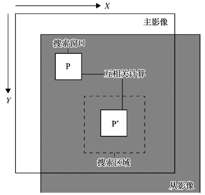
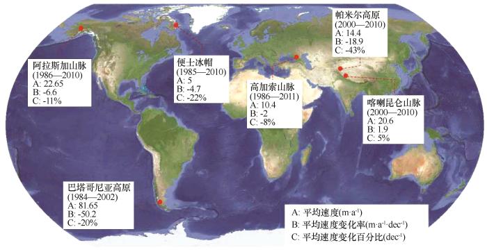
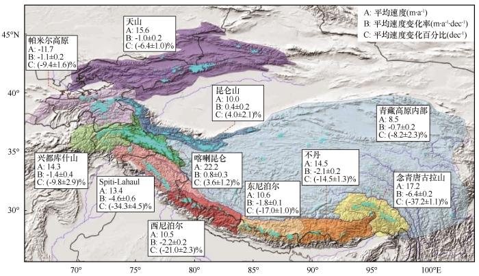

 甘公网安备 62010202000676号