Ecological characteristics of mountains and research issues of mountain ecology
2
2004
... 高寒山区是内陆河流域重要的水源涵养区,山区生态系统中土壤和植被的格局与演化将导致出山径流发生变化,对中下游农田和荒漠绿洲区的生态安全造成影响.高寒山区的生态系统本身较为脆弱且对气候变化响应敏感,在气候变暖和人类活动的影响下土壤和植被可能发生退化,进而导致生态系统功能减弱或丧失.然而,高寒山区下垫面复杂,水热梯度巨大,地形因子主导下的水热格局对山区生态系统中土壤和植被空间异质性的影响依然不清.定量描述地形梯度上土壤和植被属性的变化规律,有助于理解山区复杂地形条件下土壤和植被的空间异质性,进而确定生态恢复的高保护价值区,明确生态退化区的土壤及植被恢复潜力,对制定气候变化条件下有效生态保护和恢复措施具有重要意义[1-2]. ...
... 地形是塑造山区土壤和植被格局的重要环境因子,特别是海拔,通过改变垂直方向上的温度及降水格局,使土壤和植被类型呈明显的垂直地带性分布[1].在同一海拔带内,坡向和坡位通过改变坡面接收的太阳辐射量和水文过程,形成影响山区小尺度上土壤及植被格局的重要微地形因子[3-4].研究发现,阴坡因水热组合优于阳坡,其植被生物量和土壤碳、氮含量通常高于阳坡[4-7].而从山顶到山谷,在土壤侵蚀程度逐渐加重的情况下,植被和土壤养分的变化趋势与之相反[8-9].坡向和坡位在小尺度上对成土过程和植被生长的重塑,是同一海拔带内土壤和植被属性空间异质性的主要来源.准确理解这种异质性,对山区生态退化区土壤和植被的重建具有重要的参考价值. ...
试论山地的生态特征及山地生态学的研究内容
2
2004
... 高寒山区是内陆河流域重要的水源涵养区,山区生态系统中土壤和植被的格局与演化将导致出山径流发生变化,对中下游农田和荒漠绿洲区的生态安全造成影响.高寒山区的生态系统本身较为脆弱且对气候变化响应敏感,在气候变暖和人类活动的影响下土壤和植被可能发生退化,进而导致生态系统功能减弱或丧失.然而,高寒山区下垫面复杂,水热梯度巨大,地形因子主导下的水热格局对山区生态系统中土壤和植被空间异质性的影响依然不清.定量描述地形梯度上土壤和植被属性的变化规律,有助于理解山区复杂地形条件下土壤和植被的空间异质性,进而确定生态恢复的高保护价值区,明确生态退化区的土壤及植被恢复潜力,对制定气候变化条件下有效生态保护和恢复措施具有重要意义[1-2]. ...
... 地形是塑造山区土壤和植被格局的重要环境因子,特别是海拔,通过改变垂直方向上的温度及降水格局,使土壤和植被类型呈明显的垂直地带性分布[1].在同一海拔带内,坡向和坡位通过改变坡面接收的太阳辐射量和水文过程,形成影响山区小尺度上土壤及植被格局的重要微地形因子[3-4].研究发现,阴坡因水热组合优于阳坡,其植被生物量和土壤碳、氮含量通常高于阳坡[4-7].而从山顶到山谷,在土壤侵蚀程度逐渐加重的情况下,植被和土壤养分的变化趋势与之相反[8-9].坡向和坡位在小尺度上对成土过程和植被生长的重塑,是同一海拔带内土壤和植被属性空间异质性的主要来源.准确理解这种异质性,对山区生态退化区土壤和植被的重建具有重要的参考价值. ...
Soil water content and temperature of the active layer dynamics on the slope of the Fenghuoshan basin, Tibetan Plateau
2
2020
... 高寒山区是内陆河流域重要的水源涵养区,山区生态系统中土壤和植被的格局与演化将导致出山径流发生变化,对中下游农田和荒漠绿洲区的生态安全造成影响.高寒山区的生态系统本身较为脆弱且对气候变化响应敏感,在气候变暖和人类活动的影响下土壤和植被可能发生退化,进而导致生态系统功能减弱或丧失.然而,高寒山区下垫面复杂,水热梯度巨大,地形因子主导下的水热格局对山区生态系统中土壤和植被空间异质性的影响依然不清.定量描述地形梯度上土壤和植被属性的变化规律,有助于理解山区复杂地形条件下土壤和植被的空间异质性,进而确定生态恢复的高保护价值区,明确生态退化区的土壤及植被恢复潜力,对制定气候变化条件下有效生态保护和恢复措施具有重要意义[1-2]. ...
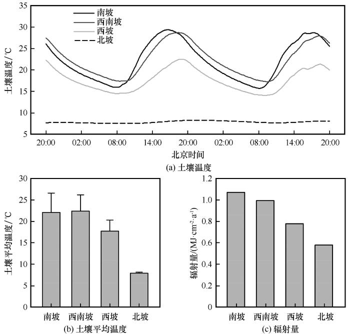
... 本研究中各样方海拔接近,考虑到研究区年平均降水和温度是海拔的函数,因此各样方大的气候背景接近,但受坡向和坡位的影响,土壤温湿度在同一海拔带内发生显著变化,不同地形部位土壤属性和植被生物量差异巨大[2,4,17].本研究中土壤温度、含水量和年潜在直接入射辐射量从南坡到北坡变化显著,这与刘旻霞等[18]、Rorison等[19]学者关于不同坡向土壤水热分布的研究结果类似.但祁连山森林草原带南北坡的土壤温差更大,达14.2 ℃,这主要与坡向塑造下的植被格局有关.祁连山森林草原带内,随着坡向由南转北,植被类型从以冰草为主的山地草原(南-西南坡)过渡到以嵩草和苔草为主的山地草甸(西坡),在西北-北坡时已完全转变为青海云杉林,形成了半干旱山区特有的“南草北树”景观[4].青海云杉林冠层的遮蔽效应大大减少了土壤表层接受的辐射量,因此北坡林内土壤温度远低于南坡.本研究中,南北坡土壤水分相差巨大,北坡约南坡的2.07倍,原因在于北坡森林对水源涵养的能力要高于南坡草地,降雨多截留在土壤中.另外,山谷土壤含水量显著高于山坡和山顶,这主要是因为山坡上地表径流和壤中流在山谷汇聚,使得山谷获得额外的水分,土壤含水量也相应增加[20]. ...
青藏高原风火山流域坡面尺度活动层土壤水热时空变化特征
2
2020
... 高寒山区是内陆河流域重要的水源涵养区,山区生态系统中土壤和植被的格局与演化将导致出山径流发生变化,对中下游农田和荒漠绿洲区的生态安全造成影响.高寒山区的生态系统本身较为脆弱且对气候变化响应敏感,在气候变暖和人类活动的影响下土壤和植被可能发生退化,进而导致生态系统功能减弱或丧失.然而,高寒山区下垫面复杂,水热梯度巨大,地形因子主导下的水热格局对山区生态系统中土壤和植被空间异质性的影响依然不清.定量描述地形梯度上土壤和植被属性的变化规律,有助于理解山区复杂地形条件下土壤和植被的空间异质性,进而确定生态恢复的高保护价值区,明确生态退化区的土壤及植被恢复潜力,对制定气候变化条件下有效生态保护和恢复措施具有重要意义[1-2]. ...
... 本研究中各样方海拔接近,考虑到研究区年平均降水和温度是海拔的函数,因此各样方大的气候背景接近,但受坡向和坡位的影响,土壤温湿度在同一海拔带内发生显著变化,不同地形部位土壤属性和植被生物量差异巨大[2,4,17].本研究中土壤温度、含水量和年潜在直接入射辐射量从南坡到北坡变化显著,这与刘旻霞等[18]、Rorison等[19]学者关于不同坡向土壤水热分布的研究结果类似.但祁连山森林草原带南北坡的土壤温差更大,达14.2 ℃,这主要与坡向塑造下的植被格局有关.祁连山森林草原带内,随着坡向由南转北,植被类型从以冰草为主的山地草原(南-西南坡)过渡到以嵩草和苔草为主的山地草甸(西坡),在西北-北坡时已完全转变为青海云杉林,形成了半干旱山区特有的“南草北树”景观[4].青海云杉林冠层的遮蔽效应大大减少了土壤表层接受的辐射量,因此北坡林内土壤温度远低于南坡.本研究中,南北坡土壤水分相差巨大,北坡约南坡的2.07倍,原因在于北坡森林对水源涵养的能力要高于南坡草地,降雨多截留在土壤中.另外,山谷土壤含水量显著高于山坡和山顶,这主要是因为山坡上地表径流和壤中流在山谷汇聚,使得山谷获得额外的水分,土壤含水量也相应增加[20]. ...
Soil nutrient of evergreen broad-leaved forests in different slope aspects and slope positions in Nabanhe Nature Reserve
1
2016
... 地形是塑造山区土壤和植被格局的重要环境因子,特别是海拔,通过改变垂直方向上的温度及降水格局,使土壤和植被类型呈明显的垂直地带性分布[1].在同一海拔带内,坡向和坡位通过改变坡面接收的太阳辐射量和水文过程,形成影响山区小尺度上土壤及植被格局的重要微地形因子[3-4].研究发现,阴坡因水热组合优于阳坡,其植被生物量和土壤碳、氮含量通常高于阳坡[4-7].而从山顶到山谷,在土壤侵蚀程度逐渐加重的情况下,植被和土壤养分的变化趋势与之相反[8-9].坡向和坡位在小尺度上对成土过程和植被生长的重塑,是同一海拔带内土壤和植被属性空间异质性的主要来源.准确理解这种异质性,对山区生态退化区土壤和植被的重建具有重要的参考价值. ...
纳板河自然保护区不同坡向和坡位的常绿阔叶林土壤养分
1
2016
... 地形是塑造山区土壤和植被格局的重要环境因子,特别是海拔,通过改变垂直方向上的温度及降水格局,使土壤和植被类型呈明显的垂直地带性分布[1].在同一海拔带内,坡向和坡位通过改变坡面接收的太阳辐射量和水文过程,形成影响山区小尺度上土壤及植被格局的重要微地形因子[3-4].研究发现,阴坡因水热组合优于阳坡,其植被生物量和土壤碳、氮含量通常高于阳坡[4-7].而从山顶到山谷,在土壤侵蚀程度逐渐加重的情况下,植被和土壤养分的变化趋势与之相反[8-9].坡向和坡位在小尺度上对成土过程和植被生长的重塑,是同一海拔带内土壤和植被属性空间异质性的主要来源.准确理解这种异质性,对山区生态退化区土壤和植被的重建具有重要的参考价值. ...
Variation in soil organic carbon by slope aspect in the middle of the Qilian Mountains in the upper Heihe River Basin, China
4
2016
... 地形是塑造山区土壤和植被格局的重要环境因子,特别是海拔,通过改变垂直方向上的温度及降水格局,使土壤和植被类型呈明显的垂直地带性分布[1].在同一海拔带内,坡向和坡位通过改变坡面接收的太阳辐射量和水文过程,形成影响山区小尺度上土壤及植被格局的重要微地形因子[3-4].研究发现,阴坡因水热组合优于阳坡,其植被生物量和土壤碳、氮含量通常高于阳坡[4-7].而从山顶到山谷,在土壤侵蚀程度逐渐加重的情况下,植被和土壤养分的变化趋势与之相反[8-9].坡向和坡位在小尺度上对成土过程和植被生长的重塑,是同一海拔带内土壤和植被属性空间异质性的主要来源.准确理解这种异质性,对山区生态退化区土壤和植被的重建具有重要的参考价值. ...
... [4-7].而从山顶到山谷,在土壤侵蚀程度逐渐加重的情况下,植被和土壤养分的变化趋势与之相反[8-9].坡向和坡位在小尺度上对成土过程和植被生长的重塑,是同一海拔带内土壤和植被属性空间异质性的主要来源.准确理解这种异质性,对山区生态退化区土壤和植被的重建具有重要的参考价值. ...
... 本研究中各样方海拔接近,考虑到研究区年平均降水和温度是海拔的函数,因此各样方大的气候背景接近,但受坡向和坡位的影响,土壤温湿度在同一海拔带内发生显著变化,不同地形部位土壤属性和植被生物量差异巨大[2,4,17].本研究中土壤温度、含水量和年潜在直接入射辐射量从南坡到北坡变化显著,这与刘旻霞等[18]、Rorison等[19]学者关于不同坡向土壤水热分布的研究结果类似.但祁连山森林草原带南北坡的土壤温差更大,达14.2 ℃,这主要与坡向塑造下的植被格局有关.祁连山森林草原带内,随着坡向由南转北,植被类型从以冰草为主的山地草原(南-西南坡)过渡到以嵩草和苔草为主的山地草甸(西坡),在西北-北坡时已完全转变为青海云杉林,形成了半干旱山区特有的“南草北树”景观[4].青海云杉林冠层的遮蔽效应大大减少了土壤表层接受的辐射量,因此北坡林内土壤温度远低于南坡.本研究中,南北坡土壤水分相差巨大,北坡约南坡的2.07倍,原因在于北坡森林对水源涵养的能力要高于南坡草地,降雨多截留在土壤中.另外,山谷土壤含水量显著高于山坡和山顶,这主要是因为山坡上地表径流和壤中流在山谷汇聚,使得山谷获得额外的水分,土壤含水量也相应增加[20]. ...
... [4].青海云杉林冠层的遮蔽效应大大减少了土壤表层接受的辐射量,因此北坡林内土壤温度远低于南坡.本研究中,南北坡土壤水分相差巨大,北坡约南坡的2.07倍,原因在于北坡森林对水源涵养的能力要高于南坡草地,降雨多截留在土壤中.另外,山谷土壤含水量显著高于山坡和山顶,这主要是因为山坡上地表径流和壤中流在山谷汇聚,使得山谷获得额外的水分,土壤含水量也相应增加[20]. ...
Spatial distribution of soil carbon in pastures with cow-calf operation: effects of slope aspect and slope position
0
2010
Soil organic carbon as a function of land use and topography on the Loess Plateau of China
1
2015
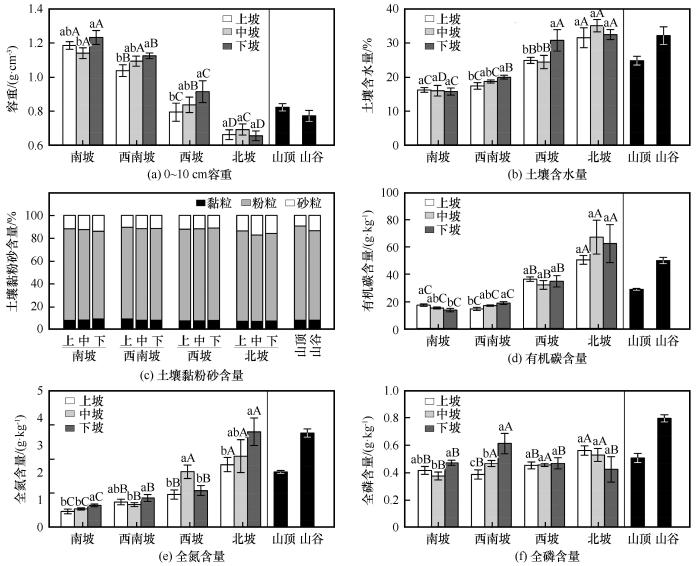
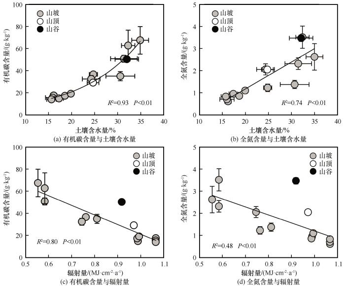
... 本研究中土壤容重为:北坡<西坡<西南坡<南坡,山谷和山顶与西坡中坡位接近.这是因为北坡为青海云杉林,林下阴湿寒冷,地表腐殖质累积多,土壤疏松;西坡、山谷和山顶表层地下生物量显著高于西南坡和南坡,草根密集,土壤较为疏松,因此容重较小.全山范围内砂、黏、粉含量接近,土壤质地为粉壤土.孙文义等在黄土高原的研究发现[6],由于土壤侵蚀作用,土壤细颗粒被搬运到沟底,使得沟底黏粒含量显著高于峁顶和峁坡.本研究各坡位黏粒含量接近,无显著差异,这可能是因为森林草原带内植被覆盖度较高且极端降水事件较少,土壤侵蚀强度较低,尤其是在阴坡青海云杉林内,由于林冠截留作用及土壤表层苔藓对水分的涵养作用,林区内无土壤侵蚀发生[21].土壤有机碳和全氮含量的变化趋势均为:北坡>西坡>西南坡>南坡,山谷与北坡下坡接近,山顶与西坡中坡接近.回归分析表明,土壤有机碳和全氮含量随着土壤含水量的增加呈指数和线性增加趋势.其原因在于水分条件好的坡面植被生物量高,进入土壤中的凋落物多,土壤有机碳和全氮含量更高[22].此外,坡向梯度上土壤全磷含量差异不显著,土壤全磷与水热因子也未表现出显著的相关性.这主要是因为土壤中磷除小部分来自干湿沉降外,大多数来自土壤母质[23].山谷较高的全磷含量可能与磷随地表径流的迁移有关,山坡上的磷随地表径流流失,并在山谷汇集,使山谷土壤全磷含量显著增加. ...
Research on the spatial variation characteristics of soil moisture and temperature in Dayekou basin of the Qilian Mountains
1
2015
... 地形是塑造山区土壤和植被格局的重要环境因子,特别是海拔,通过改变垂直方向上的温度及降水格局,使土壤和植被类型呈明显的垂直地带性分布[1].在同一海拔带内,坡向和坡位通过改变坡面接收的太阳辐射量和水文过程,形成影响山区小尺度上土壤及植被格局的重要微地形因子[3-4].研究发现,阴坡因水热组合优于阳坡,其植被生物量和土壤碳、氮含量通常高于阳坡[4-7].而从山顶到山谷,在土壤侵蚀程度逐渐加重的情况下,植被和土壤养分的变化趋势与之相反[8-9].坡向和坡位在小尺度上对成土过程和植被生长的重塑,是同一海拔带内土壤和植被属性空间异质性的主要来源.准确理解这种异质性,对山区生态退化区土壤和植被的重建具有重要的参考价值. ...
祁连山大野口流域土壤水热空间变化特征研究
1
2015
... 地形是塑造山区土壤和植被格局的重要环境因子,特别是海拔,通过改变垂直方向上的温度及降水格局,使土壤和植被类型呈明显的垂直地带性分布[1].在同一海拔带内,坡向和坡位通过改变坡面接收的太阳辐射量和水文过程,形成影响山区小尺度上土壤及植被格局的重要微地形因子[3-4].研究发现,阴坡因水热组合优于阳坡,其植被生物量和土壤碳、氮含量通常高于阳坡[4-7].而从山顶到山谷,在土壤侵蚀程度逐渐加重的情况下,植被和土壤养分的变化趋势与之相反[8-9].坡向和坡位在小尺度上对成土过程和植被生长的重塑,是同一海拔带内土壤和植被属性空间异质性的主要来源.准确理解这种异质性,对山区生态退化区土壤和植被的重建具有重要的参考价值. ...
Effect of slope position on soil physicochemical properties, enzyme activities and microbial properties in Pinus massoniana plantation
1
2010
... 地形是塑造山区土壤和植被格局的重要环境因子,特别是海拔,通过改变垂直方向上的温度及降水格局,使土壤和植被类型呈明显的垂直地带性分布[1].在同一海拔带内,坡向和坡位通过改变坡面接收的太阳辐射量和水文过程,形成影响山区小尺度上土壤及植被格局的重要微地形因子[3-4].研究发现,阴坡因水热组合优于阳坡,其植被生物量和土壤碳、氮含量通常高于阳坡[4-7].而从山顶到山谷,在土壤侵蚀程度逐渐加重的情况下,植被和土壤养分的变化趋势与之相反[8-9].坡向和坡位在小尺度上对成土过程和植被生长的重塑,是同一海拔带内土壤和植被属性空间异质性的主要来源.准确理解这种异质性,对山区生态退化区土壤和植被的重建具有重要的参考价值. ...
坡位对马尾松林下土壤理化性质、酶活性及微生物特性影响
1
2010
... 地形是塑造山区土壤和植被格局的重要环境因子,特别是海拔,通过改变垂直方向上的温度及降水格局,使土壤和植被类型呈明显的垂直地带性分布[1].在同一海拔带内,坡向和坡位通过改变坡面接收的太阳辐射量和水文过程,形成影响山区小尺度上土壤及植被格局的重要微地形因子[3-4].研究发现,阴坡因水热组合优于阳坡,其植被生物量和土壤碳、氮含量通常高于阳坡[4-7].而从山顶到山谷,在土壤侵蚀程度逐渐加重的情况下,植被和土壤养分的变化趋势与之相反[8-9].坡向和坡位在小尺度上对成土过程和植被生长的重塑,是同一海拔带内土壤和植被属性空间异质性的主要来源.准确理解这种异质性,对山区生态退化区土壤和植被的重建具有重要的参考价值. ...
Combined effect of geomorphic and pedogenic processes on the distribution of soil organic carbon quality along an eroding hillslope on loess soil
1
2014
... 地形是塑造山区土壤和植被格局的重要环境因子,特别是海拔,通过改变垂直方向上的温度及降水格局,使土壤和植被类型呈明显的垂直地带性分布[1].在同一海拔带内,坡向和坡位通过改变坡面接收的太阳辐射量和水文过程,形成影响山区小尺度上土壤及植被格局的重要微地形因子[3-4].研究发现,阴坡因水热组合优于阳坡,其植被生物量和土壤碳、氮含量通常高于阳坡[4-7].而从山顶到山谷,在土壤侵蚀程度逐渐加重的情况下,植被和土壤养分的变化趋势与之相反[8-9].坡向和坡位在小尺度上对成土过程和植被生长的重塑,是同一海拔带内土壤和植被属性空间异质性的主要来源.准确理解这种异质性,对山区生态退化区土壤和植被的重建具有重要的参考价值. ...
Distribution features of permafrost organic carbon density on different vegetation types in the upper reaches of Heihe River, Qilian Mountains
1
2018
... 祁连山是我国西北典型的高寒山区,是黑河、石羊河、疏勒河的水源地[10-11],对内陆河流域的生态安全和经济社会的可持续发展具有重要意义.山区海拔2 500~3 300 m为典型的森林和草原镶嵌景观,山地森林呈斑块状分布在阴坡及半阴坡,草地则主要分布在阳坡、半阳坡及较为平坦的山顶、山谷和台地.这种特殊的景观格局使得该区土壤和植被属性的空间格局与地形因子密切相关,为研究高寒山区小尺度上地形-土壤-植被关系提供了理想场所.本研究通过选取典型的森林草原景观进行野外调查和室内分析,对祁连山森林草原带土壤主要属性和植被生物量随坡向和坡位的变化规律及其与水热因子的关系进行了研究,旨在加深对高寒山区小尺度上土壤属性及植被生产力空间异质性的理解,进而为祁连山森林草原带内生态退化区的土壤恢复与植被重建提供基础数据参考. ...
祁连山黑河上游多年冻土区不同植被类型土壤有机碳密度分布特征
1
2018
... 祁连山是我国西北典型的高寒山区,是黑河、石羊河、疏勒河的水源地[10-11],对内陆河流域的生态安全和经济社会的可持续发展具有重要意义.山区海拔2 500~3 300 m为典型的森林和草原镶嵌景观,山地森林呈斑块状分布在阴坡及半阴坡,草地则主要分布在阳坡、半阳坡及较为平坦的山顶、山谷和台地.这种特殊的景观格局使得该区土壤和植被属性的空间格局与地形因子密切相关,为研究高寒山区小尺度上地形-土壤-植被关系提供了理想场所.本研究通过选取典型的森林草原景观进行野外调查和室内分析,对祁连山森林草原带土壤主要属性和植被生物量随坡向和坡位的变化规律及其与水热因子的关系进行了研究,旨在加深对高寒山区小尺度上土壤属性及植被生产力空间异质性的理解,进而为祁连山森林草原带内生态退化区的土壤恢复与植被重建提供基础数据参考. ...
Status and suggestions on ecological protection and restoration of Qilian Mountains
1
2017
... 祁连山是我国西北典型的高寒山区,是黑河、石羊河、疏勒河的水源地[10-11],对内陆河流域的生态安全和经济社会的可持续发展具有重要意义.山区海拔2 500~3 300 m为典型的森林和草原镶嵌景观,山地森林呈斑块状分布在阴坡及半阴坡,草地则主要分布在阳坡、半阳坡及较为平坦的山顶、山谷和台地.这种特殊的景观格局使得该区土壤和植被属性的空间格局与地形因子密切相关,为研究高寒山区小尺度上地形-土壤-植被关系提供了理想场所.本研究通过选取典型的森林草原景观进行野外调查和室内分析,对祁连山森林草原带土壤主要属性和植被生物量随坡向和坡位的变化规律及其与水热因子的关系进行了研究,旨在加深对高寒山区小尺度上土壤属性及植被生产力空间异质性的理解,进而为祁连山森林草原带内生态退化区的土壤恢复与植被重建提供基础数据参考. ...
祁连山生态保护与修复的现状问题与建议
1
2017
... 祁连山是我国西北典型的高寒山区,是黑河、石羊河、疏勒河的水源地[10-11],对内陆河流域的生态安全和经济社会的可持续发展具有重要意义.山区海拔2 500~3 300 m为典型的森林和草原镶嵌景观,山地森林呈斑块状分布在阴坡及半阴坡,草地则主要分布在阳坡、半阳坡及较为平坦的山顶、山谷和台地.这种特殊的景观格局使得该区土壤和植被属性的空间格局与地形因子密切相关,为研究高寒山区小尺度上地形-土壤-植被关系提供了理想场所.本研究通过选取典型的森林草原景观进行野外调查和室内分析,对祁连山森林草原带土壤主要属性和植被生物量随坡向和坡位的变化规律及其与水热因子的关系进行了研究,旨在加深对高寒山区小尺度上土壤属性及植被生产力空间异质性的理解,进而为祁连山森林草原带内生态退化区的土壤恢复与植被重建提供基础数据参考. ...
The climate features and regionalization of vertical climatic zones in the northern slope of Qilian Mountains
1
2001
... 研究区位于祁连山自然保护区的西水林区(38°23′~38°48′ N,100°03′~100°23′ E),属于甘肃省肃南裕固族自治县,该区气候为高寒半干旱气候,年平均气温-1.5~2.0 ℃,年降水量330~540 mm,90%的降水集中在6—9月,年均蒸发量为1 488 mm[12-13].景观格局为山地森林草原,其中草地面积约55%,主要分布在阳坡、半阳坡及地势平缓的山顶和谷地,林地面积约38%,主要分布在阴坡和半阴坡. ...
祁连山北坡中部气候特征及垂直气候带的划分
1
2001
... 研究区位于祁连山自然保护区的西水林区(38°23′~38°48′ N,100°03′~100°23′ E),属于甘肃省肃南裕固族自治县,该区气候为高寒半干旱气候,年平均气温-1.5~2.0 ℃,年降水量330~540 mm,90%的降水集中在6—9月,年均蒸发量为1 488 mm[12-13].景观格局为山地森林草原,其中草地面积约55%,主要分布在阳坡、半阳坡及地势平缓的山顶和谷地,林地面积约38%,主要分布在阴坡和半阴坡. ...
Soil cation exchange capacity and exchangeable base cation content in the profiles of four typical soils in the Xi-Shui Forest Zone of the Qilian Mountains
1
2012
... 研究区位于祁连山自然保护区的西水林区(38°23′~38°48′ N,100°03′~100°23′ E),属于甘肃省肃南裕固族自治县,该区气候为高寒半干旱气候,年平均气温-1.5~2.0 ℃,年降水量330~540 mm,90%的降水集中在6—9月,年均蒸发量为1 488 mm[12-13].景观格局为山地森林草原,其中草地面积约55%,主要分布在阳坡、半阳坡及地势平缓的山顶和谷地,林地面积约38%,主要分布在阴坡和半阴坡. ...
祁连山西水林区土壤阳离子交换量及盐基离子的剖面分布
1
2012
... 研究区位于祁连山自然保护区的西水林区(38°23′~38°48′ N,100°03′~100°23′ E),属于甘肃省肃南裕固族自治县,该区气候为高寒半干旱气候,年平均气温-1.5~2.0 ℃,年降水量330~540 mm,90%的降水集中在6—9月,年均蒸发量为1 488 mm[12-13].景观格局为山地森林草原,其中草地面积约55%,主要分布在阳坡、半阳坡及地势平缓的山顶和谷地,林地面积约38%,主要分布在阴坡和半阴坡. ...
A study on carbon balance of Picea crassifolia in Qilian Mountains
1
2000
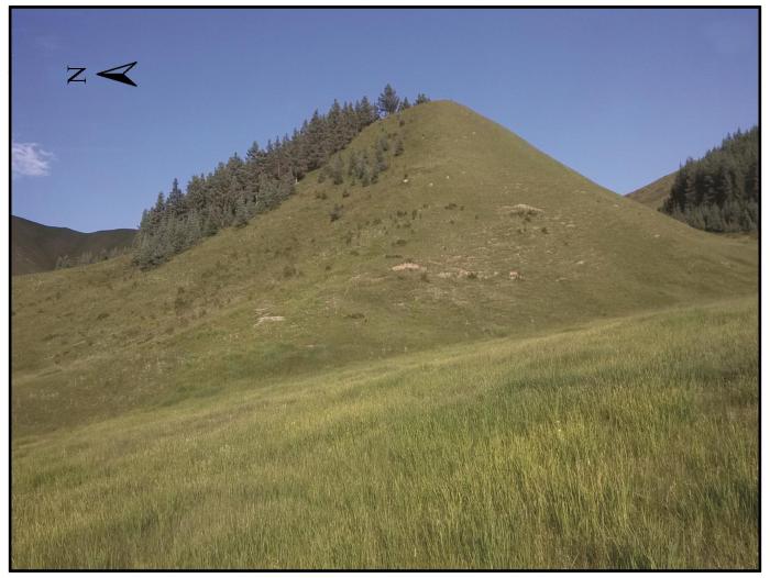
... 在南(180°)、西南(225°)、西(270°)和北坡(360°)的上坡(坡面上部1/3)、中坡(坡面中部1/3)、下坡(坡面下部1/3)及山坡底端的山谷(距离山坡底端约20~50 m)各设置一个10 m×30 m的样地,每个样地内设置3个5 m×5 m(在北坡青海云杉林,样方大小改为10 m×10 m)的样方.另外,在山顶设置3个5 m×5 m的样方(图1).调查样方内所有青海云杉的高度、冠幅和胸径,根据文献中的公式,估算林地地上和地下生物量[14].草地地上生物量的获取采用收获法,根生物量的获取采取根钻法,每个坡位3个重复.在每个样方内用直径5 cm的土钻沿对角线在0~10 cm、10~20 cm、20~40 cm和40~60 cm取样,分深度混合后得到4个混合样,用于土壤化学性质分析.另外,再挖开一个剖面,用环刀法在5、15、30和50 cm处取土,用于分析土壤容重及土壤含水量.土壤温度通过在各坡面中坡土壤5 cm深处埋设地温计获取,记录间隔为5 min.选择2015年7月29日20:00至7月31日20:00(北京时间)考察晴朗无云的天气条件下各坡面土壤温度的日变化. ...
祁连山青海云杉林碳平衡研究
1
2000
... 在南(180°)、西南(225°)、西(270°)和北坡(360°)的上坡(坡面上部1/3)、中坡(坡面中部1/3)、下坡(坡面下部1/3)及山坡底端的山谷(距离山坡底端约20~50 m)各设置一个10 m×30 m的样地,每个样地内设置3个5 m×5 m(在北坡青海云杉林,样方大小改为10 m×10 m)的样方.另外,在山顶设置3个5 m×5 m的样方(图1).调查样方内所有青海云杉的高度、冠幅和胸径,根据文献中的公式,估算林地地上和地下生物量[14].草地地上生物量的获取采用收获法,根生物量的获取采取根钻法,每个坡位3个重复.在每个样方内用直径5 cm的土钻沿对角线在0~10 cm、10~20 cm、20~40 cm和40~60 cm取样,分深度混合后得到4个混合样,用于土壤化学性质分析.另外,再挖开一个剖面,用环刀法在5、15、30和50 cm处取土,用于分析土壤容重及土壤含水量.土壤温度通过在各坡面中坡土壤5 cm深处埋设地温计获取,记录间隔为5 min.选择2015年7月29日20:00至7月31日20:00(北京时间)考察晴朗无云的天气条件下各坡面土壤温度的日变化. ...
1
1999
... 环刀采集的样品当天在野外台站用天平(精确到0.01 g)称量鲜重,然后采用烘干法获得土壤容重和含水量数据.土钻采集的样品带回实验室风干后过筛研磨,用于土壤理化性质分析,其中,土壤有机碳含量采用重铬酸钾外加热法测定,全氮含量采用半微量凯氏定氮法测定,全磷含量采用钼锑抗比色法测定[15],土壤机械组成采用激光粒度仪测定(Mastersizer 2000,英国Malvern公司).由于采样山地缺乏实测气象数据,热量条件通过计算各样地年潜在直接太阳辐射量来评估[16]. ...
1
1999
... 环刀采集的样品当天在野外台站用天平(精确到0.01 g)称量鲜重,然后采用烘干法获得土壤容重和含水量数据.土钻采集的样品带回实验室风干后过筛研磨,用于土壤理化性质分析,其中,土壤有机碳含量采用重铬酸钾外加热法测定,全氮含量采用半微量凯氏定氮法测定,全磷含量采用钼锑抗比色法测定[15],土壤机械组成采用激光粒度仪测定(Mastersizer 2000,英国Malvern公司).由于采样山地缺乏实测气象数据,热量条件通过计算各样地年潜在直接太阳辐射量来评估[16]. ...
Equations for potential annual direct incident radiation and heat load
1
2002
... 环刀采集的样品当天在野外台站用天平(精确到0.01 g)称量鲜重,然后采用烘干法获得土壤容重和含水量数据.土钻采集的样品带回实验室风干后过筛研磨,用于土壤理化性质分析,其中,土壤有机碳含量采用重铬酸钾外加热法测定,全氮含量采用半微量凯氏定氮法测定,全磷含量采用钼锑抗比色法测定[15],土壤机械组成采用激光粒度仪测定(Mastersizer 2000,英国Malvern公司).由于采样山地缺乏实测气象数据,热量条件通过计算各样地年潜在直接太阳辐射量来评估[16]. ...
Soil organic carbon as functions of slope aspects and soil depths in a semiarid alpine region of Northwest China
1
2017
... 本研究中各样方海拔接近,考虑到研究区年平均降水和温度是海拔的函数,因此各样方大的气候背景接近,但受坡向和坡位的影响,土壤温湿度在同一海拔带内发生显著变化,不同地形部位土壤属性和植被生物量差异巨大[2,4,17].本研究中土壤温度、含水量和年潜在直接入射辐射量从南坡到北坡变化显著,这与刘旻霞等[18]、Rorison等[19]学者关于不同坡向土壤水热分布的研究结果类似.但祁连山森林草原带南北坡的土壤温差更大,达14.2 ℃,这主要与坡向塑造下的植被格局有关.祁连山森林草原带内,随着坡向由南转北,植被类型从以冰草为主的山地草原(南-西南坡)过渡到以嵩草和苔草为主的山地草甸(西坡),在西北-北坡时已完全转变为青海云杉林,形成了半干旱山区特有的“南草北树”景观[4].青海云杉林冠层的遮蔽效应大大减少了土壤表层接受的辐射量,因此北坡林内土壤温度远低于南坡.本研究中,南北坡土壤水分相差巨大,北坡约南坡的2.07倍,原因在于北坡森林对水源涵养的能力要高于南坡草地,降雨多截留在土壤中.另外,山谷土壤含水量显著高于山坡和山顶,这主要是因为山坡上地表径流和壤中流在山谷汇聚,使得山谷获得额外的水分,土壤含水量也相应增加[20]. ...
Responses of plant community diversity and soil factors to slope aspect in alpine meadow
1
2013
... 本研究中各样方海拔接近,考虑到研究区年平均降水和温度是海拔的函数,因此各样方大的气候背景接近,但受坡向和坡位的影响,土壤温湿度在同一海拔带内发生显著变化,不同地形部位土壤属性和植被生物量差异巨大[2,4,17].本研究中土壤温度、含水量和年潜在直接入射辐射量从南坡到北坡变化显著,这与刘旻霞等[18]、Rorison等[19]学者关于不同坡向土壤水热分布的研究结果类似.但祁连山森林草原带南北坡的土壤温差更大,达14.2 ℃,这主要与坡向塑造下的植被格局有关.祁连山森林草原带内,随着坡向由南转北,植被类型从以冰草为主的山地草原(南-西南坡)过渡到以嵩草和苔草为主的山地草甸(西坡),在西北-北坡时已完全转变为青海云杉林,形成了半干旱山区特有的“南草北树”景观[4].青海云杉林冠层的遮蔽效应大大减少了土壤表层接受的辐射量,因此北坡林内土壤温度远低于南坡.本研究中,南北坡土壤水分相差巨大,北坡约南坡的2.07倍,原因在于北坡森林对水源涵养的能力要高于南坡草地,降雨多截留在土壤中.另外,山谷土壤含水量显著高于山坡和山顶,这主要是因为山坡上地表径流和壤中流在山谷汇聚,使得山谷获得额外的水分,土壤含水量也相应增加[20]. ...
高寒草甸植物群落多样性及土壤因子对坡向的响应
1
2013
... 本研究中各样方海拔接近,考虑到研究区年平均降水和温度是海拔的函数,因此各样方大的气候背景接近,但受坡向和坡位的影响,土壤温湿度在同一海拔带内发生显著变化,不同地形部位土壤属性和植被生物量差异巨大[2,4,17].本研究中土壤温度、含水量和年潜在直接入射辐射量从南坡到北坡变化显著,这与刘旻霞等[18]、Rorison等[19]学者关于不同坡向土壤水热分布的研究结果类似.但祁连山森林草原带南北坡的土壤温差更大,达14.2 ℃,这主要与坡向塑造下的植被格局有关.祁连山森林草原带内,随着坡向由南转北,植被类型从以冰草为主的山地草原(南-西南坡)过渡到以嵩草和苔草为主的山地草甸(西坡),在西北-北坡时已完全转变为青海云杉林,形成了半干旱山区特有的“南草北树”景观[4].青海云杉林冠层的遮蔽效应大大减少了土壤表层接受的辐射量,因此北坡林内土壤温度远低于南坡.本研究中,南北坡土壤水分相差巨大,北坡约南坡的2.07倍,原因在于北坡森林对水源涵养的能力要高于南坡草地,降雨多截留在土壤中.另外,山谷土壤含水量显著高于山坡和山顶,这主要是因为山坡上地表径流和壤中流在山谷汇聚,使得山谷获得额外的水分,土壤含水量也相应增加[20]. ...
Local climate, topography and plant growth in Lathkill Dale NNR. I. A twelve-year summary of solar radiation and temperature
1
1986
... 本研究中各样方海拔接近,考虑到研究区年平均降水和温度是海拔的函数,因此各样方大的气候背景接近,但受坡向和坡位的影响,土壤温湿度在同一海拔带内发生显著变化,不同地形部位土壤属性和植被生物量差异巨大[2,4,17].本研究中土壤温度、含水量和年潜在直接入射辐射量从南坡到北坡变化显著,这与刘旻霞等[18]、Rorison等[19]学者关于不同坡向土壤水热分布的研究结果类似.但祁连山森林草原带南北坡的土壤温差更大,达14.2 ℃,这主要与坡向塑造下的植被格局有关.祁连山森林草原带内,随着坡向由南转北,植被类型从以冰草为主的山地草原(南-西南坡)过渡到以嵩草和苔草为主的山地草甸(西坡),在西北-北坡时已完全转变为青海云杉林,形成了半干旱山区特有的“南草北树”景观[4].青海云杉林冠层的遮蔽效应大大减少了土壤表层接受的辐射量,因此北坡林内土壤温度远低于南坡.本研究中,南北坡土壤水分相差巨大,北坡约南坡的2.07倍,原因在于北坡森林对水源涵养的能力要高于南坡草地,降雨多截留在土壤中.另外,山谷土壤含水量显著高于山坡和山顶,这主要是因为山坡上地表径流和壤中流在山谷汇聚,使得山谷获得额外的水分,土壤含水量也相应增加[20]. ...
Soil physical properties and nutrient properties under different utilization styles and slope position
1
2005
... 本研究中各样方海拔接近,考虑到研究区年平均降水和温度是海拔的函数,因此各样方大的气候背景接近,但受坡向和坡位的影响,土壤温湿度在同一海拔带内发生显著变化,不同地形部位土壤属性和植被生物量差异巨大[2,4,17].本研究中土壤温度、含水量和年潜在直接入射辐射量从南坡到北坡变化显著,这与刘旻霞等[18]、Rorison等[19]学者关于不同坡向土壤水热分布的研究结果类似.但祁连山森林草原带南北坡的土壤温差更大,达14.2 ℃,这主要与坡向塑造下的植被格局有关.祁连山森林草原带内,随着坡向由南转北,植被类型从以冰草为主的山地草原(南-西南坡)过渡到以嵩草和苔草为主的山地草甸(西坡),在西北-北坡时已完全转变为青海云杉林,形成了半干旱山区特有的“南草北树”景观[4].青海云杉林冠层的遮蔽效应大大减少了土壤表层接受的辐射量,因此北坡林内土壤温度远低于南坡.本研究中,南北坡土壤水分相差巨大,北坡约南坡的2.07倍,原因在于北坡森林对水源涵养的能力要高于南坡草地,降雨多截留在土壤中.另外,山谷土壤含水量显著高于山坡和山顶,这主要是因为山坡上地表径流和壤中流在山谷汇聚,使得山谷获得额外的水分,土壤含水量也相应增加[20]. ...
不同利用方式与坡位土壤物理性质及养分特征分析
1
2005
... 本研究中各样方海拔接近,考虑到研究区年平均降水和温度是海拔的函数,因此各样方大的气候背景接近,但受坡向和坡位的影响,土壤温湿度在同一海拔带内发生显著变化,不同地形部位土壤属性和植被生物量差异巨大[2,4,17].本研究中土壤温度、含水量和年潜在直接入射辐射量从南坡到北坡变化显著,这与刘旻霞等[18]、Rorison等[19]学者关于不同坡向土壤水热分布的研究结果类似.但祁连山森林草原带南北坡的土壤温差更大,达14.2 ℃,这主要与坡向塑造下的植被格局有关.祁连山森林草原带内,随着坡向由南转北,植被类型从以冰草为主的山地草原(南-西南坡)过渡到以嵩草和苔草为主的山地草甸(西坡),在西北-北坡时已完全转变为青海云杉林,形成了半干旱山区特有的“南草北树”景观[4].青海云杉林冠层的遮蔽效应大大减少了土壤表层接受的辐射量,因此北坡林内土壤温度远低于南坡.本研究中,南北坡土壤水分相差巨大,北坡约南坡的2.07倍,原因在于北坡森林对水源涵养的能力要高于南坡草地,降雨多截留在土壤中.另外,山谷土壤含水量显著高于山坡和山顶,这主要是因为山坡上地表径流和壤中流在山谷汇聚,使得山谷获得额外的水分,土壤含水量也相应增加[20]. ...
A preliminary study of water and soil erosion conditions in Sidalong Forest region in the Qilian Mountain Areas
1
1992
... 本研究中土壤容重为:北坡<西坡<西南坡<南坡,山谷和山顶与西坡中坡位接近.这是因为北坡为青海云杉林,林下阴湿寒冷,地表腐殖质累积多,土壤疏松;西坡、山谷和山顶表层地下生物量显著高于西南坡和南坡,草根密集,土壤较为疏松,因此容重较小.全山范围内砂、黏、粉含量接近,土壤质地为粉壤土.孙文义等在黄土高原的研究发现[6],由于土壤侵蚀作用,土壤细颗粒被搬运到沟底,使得沟底黏粒含量显著高于峁顶和峁坡.本研究各坡位黏粒含量接近,无显著差异,这可能是因为森林草原带内植被覆盖度较高且极端降水事件较少,土壤侵蚀强度较低,尤其是在阴坡青海云杉林内,由于林冠截留作用及土壤表层苔藓对水分的涵养作用,林区内无土壤侵蚀发生[21].土壤有机碳和全氮含量的变化趋势均为:北坡>西坡>西南坡>南坡,山谷与北坡下坡接近,山顶与西坡中坡接近.回归分析表明,土壤有机碳和全氮含量随着土壤含水量的增加呈指数和线性增加趋势.其原因在于水分条件好的坡面植被生物量高,进入土壤中的凋落物多,土壤有机碳和全氮含量更高[22].此外,坡向梯度上土壤全磷含量差异不显著,土壤全磷与水热因子也未表现出显著的相关性.这主要是因为土壤中磷除小部分来自干湿沉降外,大多数来自土壤母质[23].山谷较高的全磷含量可能与磷随地表径流的迁移有关,山坡上的磷随地表径流流失,并在山谷汇集,使山谷土壤全磷含量显著增加. ...
祁连山寺大隆林区水土流失状况的初步研究
1
1992
... 本研究中土壤容重为:北坡<西坡<西南坡<南坡,山谷和山顶与西坡中坡位接近.这是因为北坡为青海云杉林,林下阴湿寒冷,地表腐殖质累积多,土壤疏松;西坡、山谷和山顶表层地下生物量显著高于西南坡和南坡,草根密集,土壤较为疏松,因此容重较小.全山范围内砂、黏、粉含量接近,土壤质地为粉壤土.孙文义等在黄土高原的研究发现[6],由于土壤侵蚀作用,土壤细颗粒被搬运到沟底,使得沟底黏粒含量显著高于峁顶和峁坡.本研究各坡位黏粒含量接近,无显著差异,这可能是因为森林草原带内植被覆盖度较高且极端降水事件较少,土壤侵蚀强度较低,尤其是在阴坡青海云杉林内,由于林冠截留作用及土壤表层苔藓对水分的涵养作用,林区内无土壤侵蚀发生[21].土壤有机碳和全氮含量的变化趋势均为:北坡>西坡>西南坡>南坡,山谷与北坡下坡接近,山顶与西坡中坡接近.回归分析表明,土壤有机碳和全氮含量随着土壤含水量的增加呈指数和线性增加趋势.其原因在于水分条件好的坡面植被生物量高,进入土壤中的凋落物多,土壤有机碳和全氮含量更高[22].此外,坡向梯度上土壤全磷含量差异不显著,土壤全磷与水热因子也未表现出显著的相关性.这主要是因为土壤中磷除小部分来自干湿沉降外,大多数来自土壤母质[23].山谷较高的全磷含量可能与磷随地表径流的迁移有关,山坡上的磷随地表径流流失,并在山谷汇集,使山谷土壤全磷含量显著增加. ...
Impacts of climate warming on soil organic carbon pools in permafrost regions
1
2020
... 本研究中土壤容重为:北坡<西坡<西南坡<南坡,山谷和山顶与西坡中坡位接近.这是因为北坡为青海云杉林,林下阴湿寒冷,地表腐殖质累积多,土壤疏松;西坡、山谷和山顶表层地下生物量显著高于西南坡和南坡,草根密集,土壤较为疏松,因此容重较小.全山范围内砂、黏、粉含量接近,土壤质地为粉壤土.孙文义等在黄土高原的研究发现[6],由于土壤侵蚀作用,土壤细颗粒被搬运到沟底,使得沟底黏粒含量显著高于峁顶和峁坡.本研究各坡位黏粒含量接近,无显著差异,这可能是因为森林草原带内植被覆盖度较高且极端降水事件较少,土壤侵蚀强度较低,尤其是在阴坡青海云杉林内,由于林冠截留作用及土壤表层苔藓对水分的涵养作用,林区内无土壤侵蚀发生[21].土壤有机碳和全氮含量的变化趋势均为:北坡>西坡>西南坡>南坡,山谷与北坡下坡接近,山顶与西坡中坡接近.回归分析表明,土壤有机碳和全氮含量随着土壤含水量的增加呈指数和线性增加趋势.其原因在于水分条件好的坡面植被生物量高,进入土壤中的凋落物多,土壤有机碳和全氮含量更高[22].此外,坡向梯度上土壤全磷含量差异不显著,土壤全磷与水热因子也未表现出显著的相关性.这主要是因为土壤中磷除小部分来自干湿沉降外,大多数来自土壤母质[23].山谷较高的全磷含量可能与磷随地表径流的迁移有关,山坡上的磷随地表径流流失,并在山谷汇集,使山谷土壤全磷含量显著增加. ...
气候变暖对多年冻土区土壤有机碳库的影响
1
2020
... 本研究中土壤容重为:北坡<西坡<西南坡<南坡,山谷和山顶与西坡中坡位接近.这是因为北坡为青海云杉林,林下阴湿寒冷,地表腐殖质累积多,土壤疏松;西坡、山谷和山顶表层地下生物量显著高于西南坡和南坡,草根密集,土壤较为疏松,因此容重较小.全山范围内砂、黏、粉含量接近,土壤质地为粉壤土.孙文义等在黄土高原的研究发现[6],由于土壤侵蚀作用,土壤细颗粒被搬运到沟底,使得沟底黏粒含量显著高于峁顶和峁坡.本研究各坡位黏粒含量接近,无显著差异,这可能是因为森林草原带内植被覆盖度较高且极端降水事件较少,土壤侵蚀强度较低,尤其是在阴坡青海云杉林内,由于林冠截留作用及土壤表层苔藓对水分的涵养作用,林区内无土壤侵蚀发生[21].土壤有机碳和全氮含量的变化趋势均为:北坡>西坡>西南坡>南坡,山谷与北坡下坡接近,山顶与西坡中坡接近.回归分析表明,土壤有机碳和全氮含量随着土壤含水量的增加呈指数和线性增加趋势.其原因在于水分条件好的坡面植被生物量高,进入土壤中的凋落物多,土壤有机碳和全氮含量更高[22].此外,坡向梯度上土壤全磷含量差异不显著,土壤全磷与水热因子也未表现出显著的相关性.这主要是因为土壤中磷除小部分来自干湿沉降外,大多数来自土壤母质[23].山谷较高的全磷含量可能与磷随地表径流的迁移有关,山坡上的磷随地表径流流失,并在山谷汇集,使山谷土壤全磷含量显著增加. ...
Influences of grassland desertification on soil particles composition and soil phosphorus and potassium nutrients in northwestern Sichuan
1
2015
... 本研究中土壤容重为:北坡<西坡<西南坡<南坡,山谷和山顶与西坡中坡位接近.这是因为北坡为青海云杉林,林下阴湿寒冷,地表腐殖质累积多,土壤疏松;西坡、山谷和山顶表层地下生物量显著高于西南坡和南坡,草根密集,土壤较为疏松,因此容重较小.全山范围内砂、黏、粉含量接近,土壤质地为粉壤土.孙文义等在黄土高原的研究发现[6],由于土壤侵蚀作用,土壤细颗粒被搬运到沟底,使得沟底黏粒含量显著高于峁顶和峁坡.本研究各坡位黏粒含量接近,无显著差异,这可能是因为森林草原带内植被覆盖度较高且极端降水事件较少,土壤侵蚀强度较低,尤其是在阴坡青海云杉林内,由于林冠截留作用及土壤表层苔藓对水分的涵养作用,林区内无土壤侵蚀发生[21].土壤有机碳和全氮含量的变化趋势均为:北坡>西坡>西南坡>南坡,山谷与北坡下坡接近,山顶与西坡中坡接近.回归分析表明,土壤有机碳和全氮含量随着土壤含水量的增加呈指数和线性增加趋势.其原因在于水分条件好的坡面植被生物量高,进入土壤中的凋落物多,土壤有机碳和全氮含量更高[22].此外,坡向梯度上土壤全磷含量差异不显著,土壤全磷与水热因子也未表现出显著的相关性.这主要是因为土壤中磷除小部分来自干湿沉降外,大多数来自土壤母质[23].山谷较高的全磷含量可能与磷随地表径流的迁移有关,山坡上的磷随地表径流流失,并在山谷汇集,使山谷土壤全磷含量显著增加. ...
川西北草地沙化对土壤颗粒组成和土壤磷钾养分的影响
1
2015
... 本研究中土壤容重为:北坡<西坡<西南坡<南坡,山谷和山顶与西坡中坡位接近.这是因为北坡为青海云杉林,林下阴湿寒冷,地表腐殖质累积多,土壤疏松;西坡、山谷和山顶表层地下生物量显著高于西南坡和南坡,草根密集,土壤较为疏松,因此容重较小.全山范围内砂、黏、粉含量接近,土壤质地为粉壤土.孙文义等在黄土高原的研究发现[6],由于土壤侵蚀作用,土壤细颗粒被搬运到沟底,使得沟底黏粒含量显著高于峁顶和峁坡.本研究各坡位黏粒含量接近,无显著差异,这可能是因为森林草原带内植被覆盖度较高且极端降水事件较少,土壤侵蚀强度较低,尤其是在阴坡青海云杉林内,由于林冠截留作用及土壤表层苔藓对水分的涵养作用,林区内无土壤侵蚀发生[21].土壤有机碳和全氮含量的变化趋势均为:北坡>西坡>西南坡>南坡,山谷与北坡下坡接近,山顶与西坡中坡接近.回归分析表明,土壤有机碳和全氮含量随着土壤含水量的增加呈指数和线性增加趋势.其原因在于水分条件好的坡面植被生物量高,进入土壤中的凋落物多,土壤有机碳和全氮含量更高[22].此外,坡向梯度上土壤全磷含量差异不显著,土壤全磷与水热因子也未表现出显著的相关性.这主要是因为土壤中磷除小部分来自干湿沉降外,大多数来自土壤母质[23].山谷较高的全磷含量可能与磷随地表径流的迁移有关,山坡上的磷随地表径流流失,并在山谷汇集,使山谷土壤全磷含量显著增加. ...
Influence of climatic and geographic factors on the spatial distribution of Qinghai spruce forests in the dryland Qilian Mountains of Northwest China
1
2018
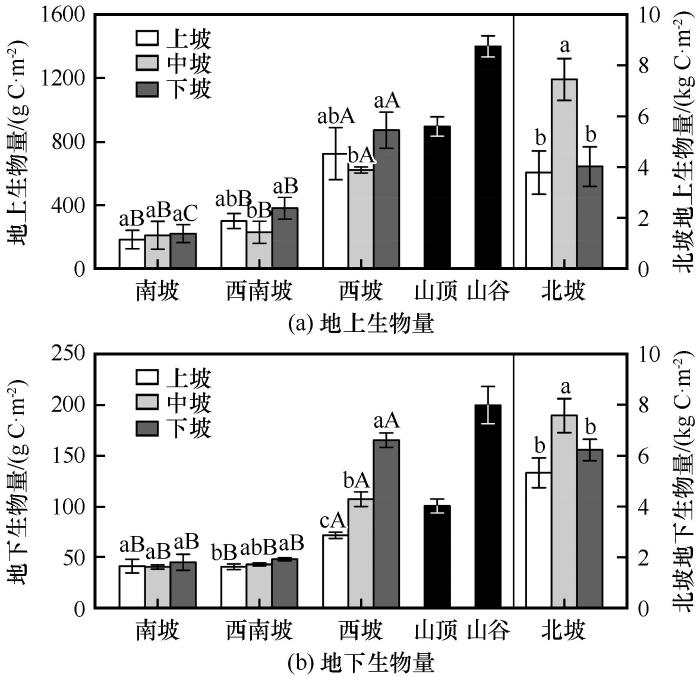
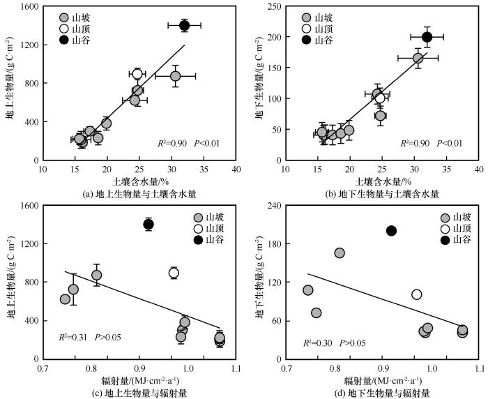
... 研究结果显示,生物量随坡向和坡位变化显著.坡向梯度上,地上和地下生物量为:西坡>西南坡>南坡,山谷最大,山顶次之,山坡最小.这与坡向和坡位影响下的土壤水分分布有关.回归分析显示,地上地下生物量随土壤含水量的增加呈线性增加趋势,土壤含水量可以解释地上地下生物量变异的90%,说明土壤水分是限制植被生物量空间分布的主要限制因子.西坡水分条件好于南坡和西南坡,山谷好于山坡和山顶,因此在这两个区域,草地地上地下生物量最大.研究区北坡为林地,中坡位生物量最大,这可能是因为中坡位于林斑内部,一方面受人类活动干扰较小,另一方面生境条件较好.研究区青海云杉多为天然次生林,阴坡中部是青海云杉适宜生长区域,森林郁闭度较高,生物量较其他坡位更大[24]. ...


 甘公网安备 62010202000676号