0 引言
摄影测量学是通过不同角度拍摄物体表面相片来还原点的空间位置,然后利用足够多的空间点重构物体形状的一门信息科学[7]。其发展经历了模拟摄影测量、解析摄影测量和数字摄影测量三个阶段。摄影测量作为一种有效的地表过程观测手段,适用于不同时空尺度的监测研究:时间上从秒到年内和年际变化;空间上可以从亚毫米到千米尺度变化[8]。这种监测手段不仅为地表过程提供精确的监测数据,还可以为模型的开发验证提供更为可靠的验证数据。同时摄影测量可以实现远程控制、无接触测量,省时省力。因此,摄影测量方法的应用研究非常广泛[9]。其中,摄影测量在积雪研究中的应用包括:获取积雪空间分布[10-15]、积雪历时[16]、雪深[17-22]、积雪截留量[23-24]、反照率参数化[25-26]、风吹雪[27-28]、粗糙度[29-30]等诸多信息。研究获取的积雪数据从2D[17-18]扩展到目前的4D(时间+空间)信息[22,31-33],预计在未来积雪研究中的应用前景广泛[34]。
相比国际,国内积雪摄影测量应用研究起步较晚,研究范围也仅限于小尺度积雪空间分布信息[35-37]和雪深提取[38]。由于缺乏成熟的4D监测设备,国内仍缺乏积雪4D监测研究。国际上,积雪4D监测研究主要利用3台以上相机,从不同角度拍摄2D相片,基于运动结构重建算法(Structure from motion,SfM),还原出相片中的三维场景,监测积雪相关特性的变化。本研究尝试利用单台相机,结合延时摄影、自动控制等技术,长时序、多角度拍摄积雪相片,利用SfM算法获取包括积雪面积、雪深等信息和空间分布的动态变化过程,从而提高积雪相关特性和动态变化监测能力,为积雪观测及其相关融雪洪水等相关灾害预报预警提供可靠的监测方法和手段。
1 积雪4D摄影测量试验方法
1.1 4D摄影测量原理
4D摄影测量利用单台相机或多台相机,长时序、多角度的拍摄被测区域,以获取重叠的影像数据,结合传统摄影测量算法或SfM算法重建长时间序列的3D信息[31-33,39]。SfM算法是直接将摄影测量与计算机视觉算法结合,对具有时间序列的多角度、多位置、有重叠的影像自动提取共有特征点,利用影像明显的特征点进行空间点位置解算和提取,进而得到空间点云以重建物体的3D模型。同时,通过特征点信息反推相机位置和角度、相机的焦距和每张影像的畸变参数[40-41]。基于SfM算法的3D建模软件包括Pix4D,Agisoft PhotoScan,LiMapper,Bundler,Visual SFM等。相比较传统摄影测量和激光雷达等测量手段,基于SfM的摄影测量方法具有操作简单,快速、便捷、成本低,而且精度与激光雷达相当或更优的特点[9,42]。本研究采用单台相机以固定频率、多角度延时拍摄重叠的照片组,结合SfM算法获取积雪信息。
1.2 测量装置
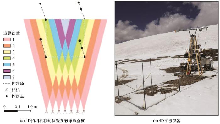
测量装置示意图见图1。相机和滑轨安装在距离地面一定高度的梯形支架上,其中相机固定在1.5 m轨道的滑块上。利用控制器模块控制轨道电机,以此精确控制滑块在轨道上移动的距离和方向,当负载有相机的滑块移动到预设的位置,利用定时快门控制相机在该位置拍摄相片。依次循环往复,设定相机在滑轨的7个等距位置分别拍摄7张相片[图1(a)]。拍摄采用佳能EOS1100D相机,相片分辨率设定为3 456×5 184 像元,快门速度同为1/160 s-1。相机焦距及光圈设定根据试验场地不同略有差异:试验点一位于黑河上游站峡谷,拍摄面积较大,因此焦距用胶带固定设置为20 mm。由于该实验点反照率低,光线较暗,光圈设定为f8。试验点二位于祁连山八一冰川,拍摄范围小,焦距固定在30 mm。鉴于雪面反照率高,光照条件好,积雪期可达11个月,所以光圈设定为f29。相机供电根据试验点条件不同有所差异:试验点一有市电,因此将220 V交流电转化为24 V直流电为轨道及相机供电;试验点二则采用太阳能+120 AH胶体电池供电。
图1
图1
测量装置示意图
Fig. 1
Schematic diagram of measuring device: 4D SfM photogrammetry camera location and image overlap (a); the 4D SfM photogrammetry device (b)
1.3 试验场地
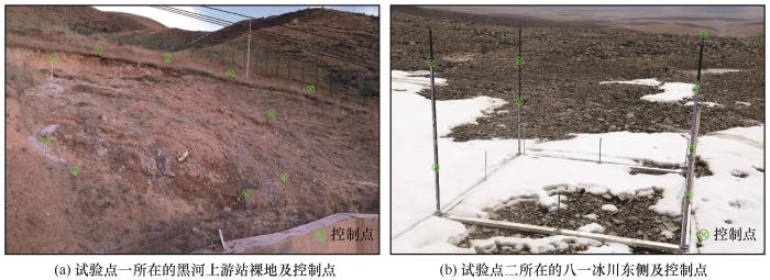
本次研究选取两个试验点:试验点一位于祁连山黑河上游生态-水文试验研究站院内山坡裸地处(99.88° E,38.27° N,2 998 m),监测范围约21 m×30 m,监测时段为2020年11月21日至30日,每日16:00拍摄(北京时间,下同)。试验点一地表有稀疏的禾本植被,在拍摄相片时候,这些植被极易受风吹、降雨等天气影响,进而影响后期获取影像和DEM的精度。为此,试验前对草地进行了刈割。由于监测面积较大,本次试验布设了10个控制点分布在其周边[图2(a)]。试验点二位于祁连山八一冰川东侧,地势平坦,无植被覆盖(98.88° E,39.02° N,4 700 m),监测范围为1.5 m×1.5 m斑块尺度的积雪动态变化过程,监测时段从2019年9月1日至2020年8月31日,监测频次为每日4次。由于试验点二雪深季节波动大,为此选用分别位于被测区域的四个角的1 m长测杆作为控制杆,8个控制点分别位于4根测杆0.05 m到1.00 m高度上[图2(b)]。
图2
图2
两个不同现场研究地点及其控制点的位置
Fig. 2
Locations of the two different field study sites and its control points: the first field test site is located at the bare slope of Qilian Alpine Ecology and Hydrology Research Station (a); the second field test site is located at the east part of the August-one ice cap (b)
1.4 技术流程
积雪4D监测技术流程主要包括:(1)地面控制点布设及定标。本次研究采用Leica D110激光测距仪测算了试验点一的10个控制点的相对坐标;试验点二则利用卷尺测算了每个控制点的相对坐标。(2)照片质量控制。由于雪面纹理特征相对单一,特别是曝光过度以及模糊的照片组对齐难度很大,所以要剔除此类照片。(3)将筛选的照片组进行控制点定位,利用PhotoScan软件进行空间解算计算稀疏点云。(4)计算密集点云,并进行质量控制,剔除奇异点。(5)利用点云数据生成数字高程模型(Digital elevation model,DEM)和正射影像数据。(6)利用正射影像数据,计算积雪面积。(7)利用积雪期DEM减去无雪期DEM,生成雪深数据DOD(Difference of DEM),据此计算并得到试验点平均雪深。
2 结果
2.1 4D摄影测量精度
2.1.1 试验点一雪深监测精度
图3
图3
利用DOD获取的2020年11月21日积雪分布及雪深分布频率
Fig. 3
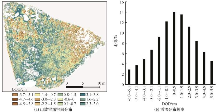
The spatial distribution of snow depth and distribution frequency of snow depth calculated based on DOD data, on November 21, 2020: spatial distribution of snow depth (a); distribution frequency of snow depth (b)
2.1.2 试验点二监测精度
试验点二积雪量大,雪面反照率较高,雪面特征点少,给影像自动对齐带来挑战。本研究总共获取了1 090个照片组(7 630张照片)。利用Photoscan软件进行了自动对齐后,168组由于雪面曝光过度、凝结或凝华遮挡相机镜头视线造成对齐失败。922组照片成功对齐并获取了点云数据。从逐月对齐的成功率来看,2019年9月1日至9月11日试验点为裸地,对齐成功率100%。9月12日至10月中旬,试验点降雪增多,消融减弱,雪面特征点少,对齐成功率随之降低到92.5%。10月中旬后期到次年3月,降雪稀少,加之风吹雪造成雪面特征点和纹理丰富,对齐成功率较高,达到97%以上。2020年4至6月,试验点降雪频次增加,新雪表面特征点少导致对齐成功率逐渐降低至58%(表1)。进入7月后,试验点积雪差异化消融造成雪表面特征和纹理增加,照片组对齐成功率相对6月略有增加,达到64%。
表1 不同月份照片组对齐比例变化
Table 1
| 时间(年-月) | 2019-09 | 2019-10 | 2019-11 | 2019-12 | 2020-01 | 2020-02 | 2020-03 | 2020-04 | 2020-05 | 2020-06 | 2020-07 | 2020-08 |
|---|---|---|---|---|---|---|---|---|---|---|---|---|
| 地表类型 | 裸地 | 雪面 | 雪面 | 雪面 | 雪面 | 雪面 | 雪面 | 雪面 | 雪面 | 雪面 | 雪面 | 雪面 |
| 照片组数 | 29 | 93 | 90 | 93 | 93 | 87 | 93 | 90 | 93 | 90 | 115 | 124 |
| 配准组数 | 29 | 86 | 90 | 93 | 91 | 87 | 90 | 83 | 69 | 51 | 74 | 79 |
| 比例/% | 100 | 92.5 | 100 | 100 | 97.8 | 100 | 96.8 | 92.2 | 74.2 | 56.7 | 64.3 | 63.7 |
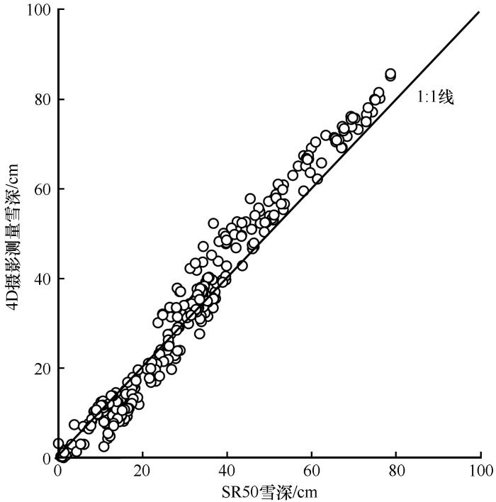
利用SR50超声探头观测雪深验证试验点二4D摄影测量观测雪深精度。研究表明:4D摄影测量获取的雪深与SR50测量的雪深有很好的一致性(图4,R=0.98,P<0.01)。不同时段分析4D摄影测量误差表明:1月到3月雪面纹理清晰,降雪较少,试验点二的老雪有利于摄影测量方法获取高精度的雪深数据,相对误差为-3.8 cm。4至6月份,由于降雪增多,雪面纹理和特征点减少,4D摄影测量获取的雪深数据误差增加至8.1 cm。夏季7—9月试验点二降雪频繁,但雪面快速消融增加了雪面纹理和特征点,相对误差降低到0.5 cm。冬季10到12月份,试验点二整体降雪少,距离地面2 m高处的观测平均风速可达5.0 m·s-1,强风引起风吹雪过程和雪面纹理增加,从而提高了4D摄影测量雪深观测精度,其相对误差为1.4 cm(表2)。总体而言,全年相对误差为1.4 cm,绝对误差为3.4 cm,均方根误差为3.1 cm。以上结果说明4D摄影测量方法在斑块尺度积雪观测精度很高;在不同季节受降水、风和消融影响,观测误差有差异,其中积累期(4—6月)最差,无降雪期(冬季11月—次年2月)以及消融期(7—9月)观测精度相对较高。
图4
图4
SR50观测的与4D摄影测量获取的雪深数据对比
Fig. 4
Consistency between observations of snow depth derived by SR 50 and the 4D SfM photogrammetry method
表2 4D摄影测量获取的雪深精度统计数据
Table 2
| 时段 | 1—3月 | 4—6月 | 7—9月 | 10—12月 | 全年 |
|---|---|---|---|---|---|
| 相对误差/cm | -3.8 | -8.1 | 0.5 | -1.5 | 1.4 |
| 绝对误差/cm | 3.8 | 8.1 | 2.5 | 2.8 | 3.4 |
| 均方根误差/cm | 3.9 | 8.3 | 3.1 | 3.2 | 3.1 |
2.2 积雪4D监测结果
2.2.1 试验点一积雪动态变化
图5
图5
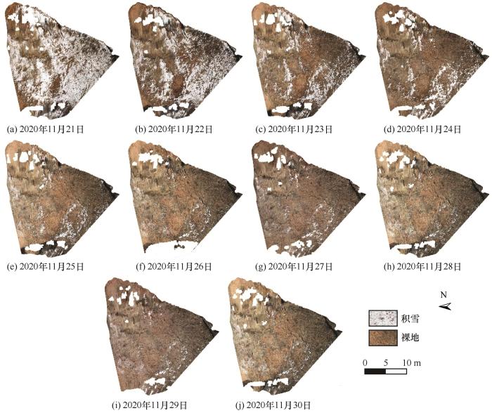
4D摄影测量正射影像捕捉的坡面尺度逐日积雪空间分布
Fig. 5
4D SfM photogrammetry captured daily snow cover distribution over slop scale
图6
图6
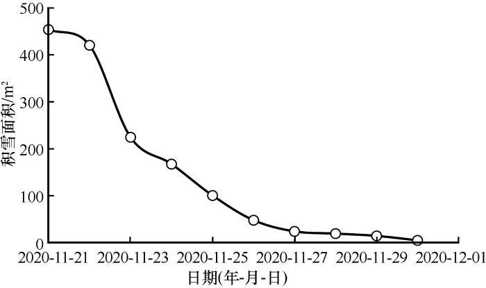
利用4D摄影测量获取的坡面尺度积雪面积变化
Fig. 6
Variation of snow covered area derived by 4D SfM photogrammetry
2.2.2 试验点二积雪动态变化
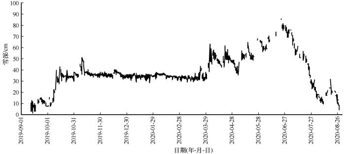
利用积雪期逐日DEM数据减去无雪期的DEM得到逐日DOD,算术平均DOD得到逐日平均雪深(图7)。从雪深变化可以看出,4D摄影测量能够很好地反映冬季积雪平稳期、春季积累期以及夏季消融期的雪深变化。但在积累期4—6月成功对齐的照片组比例较低,导致雪深缺测比例最高。
图7
图7
利用4D摄影测量获取试验点二2019-09-01—2020-08-31雪深变化
Fig. 7
Snow depth derived by 4D SfM photogrammetry in the second study site from September 1, 2019 to August 31, 2020
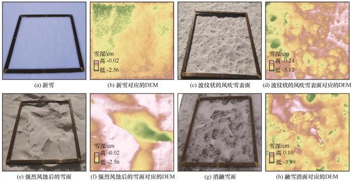
此外,利用获取的DEM数据,还可以获取斑块尺度积雪表面高程信息,分析积雪表面的形态特征。图8给出了新雪、风吹雪和差异化消雪面的基本形态特征。利用这些DEM数据不仅可以计算雪面积累、消融和雪面粗糙度等多种信息,还可以用于风吹雪和雪表粗糙度演化等过程的研究。
图8
图8
利用摄影测量获取斑块雪面表面高程数据
Fig. 8
The snow surface features and their corresponding DEM derived by 4D SfM photogrammetry: wavy wind blown snow surface (a); fresh snow surface DEM (b); snow waves formed after blowing snow event (c); DEM corresponding to wavy wind blown snow waves (d); blowing snow erosion formed snow bedforms (e); DEM of snow bedforms (f); melting snow surface (g); DEM of melting snow surface (h)
3 结论
(1)两个试验点的研究结果表明:在山坡尺度,4D摄影测量可以准确获取积雪的空间分布及积雪面积信息。而在斑块尺度,4D摄影测量还可获取包括雪深在内的动态变化过程。
(2)不同月份照片组摄影测量对齐成功率不同:裸地成功率最高,风吹雪表面对齐成功率次之,新雪表面的对齐成功率最低。DEM精度在无降雪期和消融期相对较高,积累期精度较差。
(3)尽管受拍摄视角和范围影响,地面积雪4D摄影测量范围有限,但是单台相机4D摄影测量具备高精度多目标的积雪监测能力,优于目前的诸多地面积雪监测仪器设备。为增加监测范围和提高监测精度,可以尝试利用多台相机从不同角度开展4D摄影测量研究。
参考文献
Spatial distribution and temporal variation of snow water resources in China during 1993—2002
[J].
1993—2002年中国积雪水资源时空分布与变化特征
[J].
Influence of climate change on the runoff of melting snow in the arid mountainous areas in China
[J].
气候变化对中国内陆干旱区山区融雪径流的影响
[J].
Progress and issues on key technologies in forecasting of snowmelt flood disaster in arid areas, northwest China
[J].
西北干旱区融雪洪水灾害预报预警技术: 进展与展望
[J].
Research and application situation of avalanche prevention and control engineering
[J].
雪崩防治工程研究与应用现状
[J].
Investigation on snow characteristics and their distribution in China
[J].
中国积雪特性及分布调查
[J].
Opportunities and challenges for development of digital photogrammetry
[J].
数字摄影测量发展的机遇与挑战
[J].
Image-based surface reconstruction in geomorphometry-merits, limits and developments
[J].
Applications of UAV digital aerial photogrammetry and LiDAR in geomorphology and land cover research
[J].
无人机数字摄影测量与激光雷达在地形地貌与地表覆盖研究中的应用及比较
[J].
Distributed snowmelt simulations in an alpine catchment: 1. model evaluation on the basis of snow cover patterns
[J].
Land-based remote sensing of snow for the validation of a snow transport model
[J].
Testing a distributed snowpack simulation model against spatial observations
[J].
Snow accumulation distribution inferred from time-lapse photography and simple modelling
[J].
Potential of time-lapse photography of snow for hydrological purposes at the small catchment scale
[J].
Backward snow depth reconstruction at high spatial resolution based on time-lapse photography
[J].
Evaluating observational methods to quantify snow duration under diverse forest canopies
[J].
Snow process monitoring in montane forests with time-lapse photography
[J].
Fully automated snow depth measurements from time-lapse images applying a convolutional neural network
[J].
Mapping snow depth from manned aircraft on landscape scales at centimeter resolution using structure-from-motion photogrammetry
[J].
Mapping snow depth in alpine terrain with unmanned aerial systems (UASs): Potential and limitations
[J].
Assessing the ability of structure from motion to map high-resolution snow surface elevations in complex terrain: a case study from senator beck basin, CO
[J].
Time-lapse photogrammetry of distributed snow depth during snowmelt
[J].
From observation to the quantification of snow processes with a time-lapse camera network
[J].
Snow surface albedo estimation using terrestrial photography
[J].
Acquisition of bidirectional reflectance factor dataset using a micro unmanned aerial vehicle and a consumer camera
[J].
Statistical classification of self-organized snow surfaces
[J].
The evolution of snow bedforms in the Colorado Front Range and the processes that shape them
[J].
Measuring glacier surface roughness using plot-scale, close-range digital photogrammetry
[J].
Spatial and temporal variations in glacier aerodynamic surface roughness during the melting season, as estimated at the August-one ice cap, Qilian mountains, China
[J].
Fully automated snow depth measurements from time-lapse images applying a convolutional neural network
[J].
An integrated Structure-from-Motion and time-lapse technique for quantifying ice-margin dynamics
[J].
Monitoring the snowpack volume in a sinkhole on mount Lebanon using time lapse photogrammetry
[J].
Quantifying uncertainties in snow depth mapping from structure from motion photogrammetry in an alpine area
[J].
European in situ snow measurements: Practices and purposes
[J].
Mapping snow cover based on digital photogrammetry
[J].
基于数字摄影测量的雪盖制图方法探讨
[J].
Observation and analysis of the process of snowmelting at Tianshan station using the images by digital camera
[J].
基于数字相机拍摄影像的山区积雪消融动态观测研究——以天山积雪站为例
[J].
Method of monitoring snow cover in the Antarctic great wall station based on CCD camera
[J].
利用CCD相机进行南极站积雪覆盖监测的方法
[J].
3D identification and digital photogrammetry of snow depths
[J].
积雪深度3D识别与数字摄影测量
[J].
Snow process monitoring using time-lapse structure-from-motion photogrammetry with a single camera
[J].
Straightforward reconstruction of 3D surfaces and topography with a camera: Accuracy and geoscience application
[J].
Ground-based and UAV-Based photogrammetry: A multi-scale, high-resolution mapping tool for structural geology and paleoseismology
[J].
Assessing the performance of structure-from-motion photogrammetry and terrestrial LiDAR for reconstructing soil surface microtopography of naturally vegetated plots
[J].



 甘公网安备 62010202000676号