冰川冻土, 2022, 44(4): 1270-1282 doi: 10.7522/j.issn.1000-0240.2022.0115

第四纪与行星冰冻圈

岗日嘎布玉东曲末次冰消期冰川演化及其10Be暴露测年研究

董国成,1,2, 王友琪3, 付云翀1,2, 毋宇斌1,2,4

1.中国科学院 地球环境研究所 黄土与第四纪地质国家重点实验室, 陕西 西安 710061

2.西安加速器质谱中心, 陕西 西安 710061

3.陕西省土地工程建设集团有限责任公司, 陕西 西安 710075

4.中国科学院大学, 北京 100049

Cosmogenic 10Be constraints on the last deglacial glacier behaviors in the Yudongqu Valley, Gangrigabu Range, southeast Tibetan Plateau

DONG Guocheng,1,2, WANG Youqi3, FU Yunchong1,2, WU Yubin1,2,4

1.State Key Laboratory of Loess and Quaternary Geology,Institute of Earth Environment,Chinese Academy of Sciences,Xi’an 710061,China

2.Shaanxi Key Laboratory of Accelerator Mass Spectrometry Technology and Application,Xi’an AMS Center,Xi’an 710061,China

3.Shaanxi Provincial Land Engineering Construction Group,Xi’an 710075,China

4.University of Chinese Academy of Sciences,Beijing 100049,China

收稿日期: 2022-07-15   修回日期: 2022-08-14  

基金资助: 中国科学院“西部之光”人才培养引进计划.  XAB2021YN02
中国科学院战略性先导科技专项.  XDB40000000
国家自然科学基金项目.  42071019

Received: 2022-07-15   Revised: 2022-08-14  

作者简介 About authors

董国成,副研究员,主要从事第四纪冰川与宇宙成因核素10Be和26Al暴露测年研究.E-mail:donggc@ieecas.cn , E-mail:donggc@ieecas.cn

摘要

末次冰盛期(Last Glacial Maximum, LGM)结束后,全球经历末次冰消期进入全新世,这代表了过去十万年以来最为显著的气候转型事件。末次冰消期的开始在全球范围内近乎同步,但其背后的气候驱动机制仍不明确。中低纬度,如青藏高原及其周边地区的山地冰川对气候变化响应敏感,准确限定LGM结束前后冰川地貌的时代可为上述问题的解决提供可靠的古冰川信息。然而,目前青藏高原仍缺乏足够有针对性的研究。本文选取位于青藏高原东南部的岗日嘎布作为研究区,对该区格泥峰东侧的玉东曲谷口分布的冰碛垄序列进行了详细的地貌调查和宇宙成因核素10Be暴露测年研究。采自玉东曲谷口附近6道冰碛垄中地貌相对年代较老的4道冰碛垄的14个冰川漂砾10Be暴露年龄介于(13.3±1.0)~(19.3±1.4) ka。利用累积概率密度和简化卡方等统计分析方法排除异常值后,将这4道冰碛垄中地貌相对年代较年轻两道的形成时代限定为(17.0±0.5) ka和(18.4±1.0) ka,分别对应末次冰消期和LGM后期。与气候记录进行对比后,我们认为这两次冰川波动响应可能受控于印度洋-太平洋暖池海表温度的夏季气温变化。

关键词: 10Be暴露测年 ; 末次冰消期 ; 太阳辐射 ; 印度夏季风

Abstract

The Last Glacial Termination marks the transition from the global Last Glacial Maximum (LGM) to the interglacial Holocene. This transition is the most striking climate reorganization on Earth, over the past 100 ka. The global LGM termination has been widely regarded as nearly synchronous around the world, yet, proposed mechanisms behind this synchroneity remain contentious. Mountain glaciers in the mid-latitude regions, such as those in the Tibetan Plateau (TP), are highly sensitive to climate change, and hence can provide invaluable information for clarifying this conundrum. However, glacial chronologies as regards the LGM termination remain extremely limited in the TP and its surrounding mountains. This impedes a full understanding of potential climatic mechanisms forcing glacial fluctuations in the vast TP. In this study, we examined the lateral moraine remnants formed near the valley-mouth of the Yudongqu valley, Gangrigabu Range, southeast TP, using 10Be surface exposure dating. Apparent 10Be exposure-ages (n=14) obtained from four out of six lateral moraine relics there range from (13.3±1.0) ka to (19.3±1.4) ka. On the basis of statistical test, we identified six potential outliers with the aid of probability density function plots. We then examined whether the clustering of remaining 10Be exposure-ages were merely caused by measurements or not using the reduced chi-square test and P value. After excluding the potential outliers, the two geomorphologically younger moraines were robustly dated to (17.0±0.5) ka and (18.4±1.0) ka, representing two glacial culminations that correspond well to the LGM termination. We then compared the 10Be-based moraine chronologies with climatic proxies, such as Northern Hemisphere summer solar insolation, ice-volume equivalent sea level, stalagmite δ18O record, chironomid-inferred mean July temperature record, sea surface temperature (SST), and atmospheric CO2 concentrations. We conclude that the two glacial events identified in the Yudongqu Valley were in response to changes in summer air temperature connected with SSTs in the Indo-Pacific Warm Pool (IPWP).

Keywords: 10Be surface exposure dating ; last deglaciation ; summer solar insolation ; Indian summer monsoon

PDF (9451KB) 元数据 多维度评价 相关文章 导出 EndNote| Ris| Bibtex  收藏本文

本文引用格式

董国成, 王友琪, 付云翀, 毋宇斌. 岗日嘎布玉东曲末次冰消期冰川演化及其10Be暴露测年研究[J]. 冰川冻土, 2022, 44(4): 1270-1282 doi:10.7522/j.issn.1000-0240.2022.0115

DONG Guocheng, WANG Youqi, FU Yunchong, WU Yubin. Cosmogenic 10Be constraints on the last deglacial glacier behaviors in the Yudongqu Valley, Gangrigabu Range, southeast Tibetan Plateau[J]. Journal of Glaciology and Geocryology, 2022, 44(4): 1270-1282 doi:10.7522/j.issn.1000-0240.2022.0115
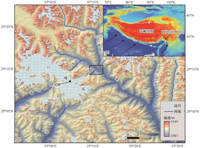
0 引言

末次冰盛期(Last Glacial Maximum, LGM, 19.0~26.5 ka)1的结束,即末次冰消期的开始,代表过去十万年以来最为显著的气候转型事件2-3。该次气候转型在全球范围内大致同步4。然而,究竟是哪些气候过程以怎样的内在联系驱动了末次冰消期在全球范围内近乎同步的开始尚无定论5-7。该问题也因此成为当今地球科学领域的研究热点和难点之一。

山地冰川作为气候变化的灵敏指示器8,对气候突变事件响应敏感9。有可靠年龄限定的冰川地貌(如冰碛垄)是古气候研究良好的素材10。过去几十年间,宇宙成因核素10Be暴露测年技术快速发展11-12,末次冰消期冰川年代学研究取得长足进展4-513-17。日渐增多的暴露测年数据表明,南北半球许多地区的山地冰川在末次冰盛期结束后约18 ka时发生了较大规模的退缩17,与南极冰芯所记录的大气CO2浓度快速升高的时间大致对应。众多研究者据此推断,温室气体(主要是CO2)在18 ka时浓度的快速增加是LGM在南北半球同步结束的主要原因4-617。近期的研究则表明,在大气CO2浓度快速升高之前,南北半球多个地点的山地冰川便已发生阶段性退缩514-1618-19。这意味着可能存在其他驱动该时期冰川变化的气候因素,例如北半球高纬夏季太阳辐射和冰盖范围的变化都可能引起全球气温的变化17

青藏高原是研究上述问题的理想地点之一:该区既远离北大西洋和北半球大陆冰盖,又远离大气CO2的释放地——南大洋20;更为重要的是,青藏高原及其周边地区的冰川对气候变化响应敏感,该区冰川地貌能够记录千年和亚千年尺度的气候突变事件21-22。大量研究已充分证明,该区LGM期间冰川规模相较末次冰期早期虽然受限,除个别地点外23-24,几乎所有山地都存在LGM冰进的证据25。但该区冰川是否在LGM结束前后发生过阶段性退缩,目前仍不清楚。

本文选取地处青藏高原东南部的岗日噶布作为研究区,针对该区玉东曲谷口所保存的冰川地貌进行详细的调查和宇宙成因核素10Be暴露测年。在此基础上,探讨玉东曲末次冰消期冰川变化的气候驱动机制,以期为青藏高原地区乃至全球末次冰消期气候驱动机制研究提供可靠的年代学证据。

1 研究区概况

岗日嘎布西接喜马拉雅山脉,东邻横断山脉的伯舒拉岭,北抵念青唐古拉山东段[图1(a)]。岗日嘎布山群呈北西-东南走向,延绵近300 km。南侧地势相对低矮,海拔一般在2 000~3 000 m,主山脊海拔超过4 000 m。因此,岗日嘎布是青藏高原受印度夏季风影响较强烈的山脉之一。如岗日嘎布南部的察隅河朝南开口的谷地,是印度夏季风向青藏高原输送水汽的重要通道之一;距离玉东曲东南约60 km的察隅县年均降水量超过800 mm,年均温接近12 ℃26

图1

图1   研究区地理位置:岗日嘎布山群(a)、玉东曲地理位置(b)[(a)中黑色的箭头代表印度夏季风,白色的箭头代表中纬度西风]

Fig. 1   Map showing the location of the study area: an inset map indicating the location of Gangrigabu mountain range (a); a shaded map showing the specific location of study area, the Yudongqu Valley, in the Gangrigabu mountain range (b) [Arrows indicate the two major climate circulations, with white denoting the northern mid-latitude westerlies, and black representing the Indian summer monsoon (a)]
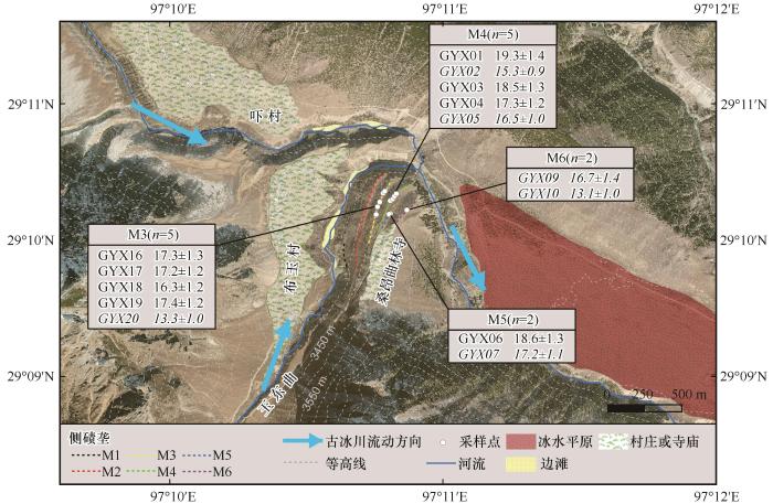

在印度夏季风影响下,该区成为我国除横断山脉之外海洋型冰川最为发育的地区27。冰川平衡线高度上年降水量可达1 000~3 000 mm,夏季平均气温超过1 ℃,冰川具有运动速度快,变幅大的特点,对气候变化的响应较为敏感28。岗日噶布发育有现代冰川1 320条,冰川面积2 655.2 km2,冰川总储量260.3 km3[29。自20世纪初至1980年,岗日嘎布地区的冰川面积减少了13.8%,总储量减少了9.8%,相当于249.2×10⁸ m3水当量30

岗日嘎布最高峰若尼峰海拔6 882 m,其周围有海拔超过6 000 m的山峰20多座,如本文研究点玉东曲东侧的格泥峰[图1(b)]。玉东曲海拔介于3 300~3 800 m,向东北方向流动约5 km后,汇入察隅河东支桑曲。

2 方法

2.1 地貌调查与制图

利用谷歌、微软和天地图等高清影像,对玉东曲谷口及其附近的冰川和其他地貌(如河流和冲积地貌等)进行判别和区分,从宏观角度整体把握研究地点附近的地貌分布特征。在此基础上,于2018年10月对玉东曲沟口附近所识别出的冰川地貌进行考察,根据地貌所处海拔、接触关系、相对位置和表面冰碛物风化程度等确定其新老关系。将所识别的冰碛垄、冰水平原以及河流地貌等在高精度影像(ArcGIS影像)上进行展示(图2)。在制图过程中,利用谷歌进行三维可视化辅助,制图标准按照已发表冰川地貌制图相关研究执行31-36

图2

图2   玉东曲谷口侧碛垄及其他地貌分布图[底图为ArcGIS影像;4道侧碛垄M3~M6的漂砾暴露年龄(ka)及样品数量在灰色方框中展示,其中异常值用斜体标记]

Fig. 2   Detailed map illustrating moraine remnants and other landforms identified near the valley-mouth of Yudongqu Valley [The apparent 10Be exposure-ages (in ka) are reported in the grey boxes with one sigma external uncertainties. The potential outliers are shown by italics. The base map is sourced from an oblique ArcGIS imagery]
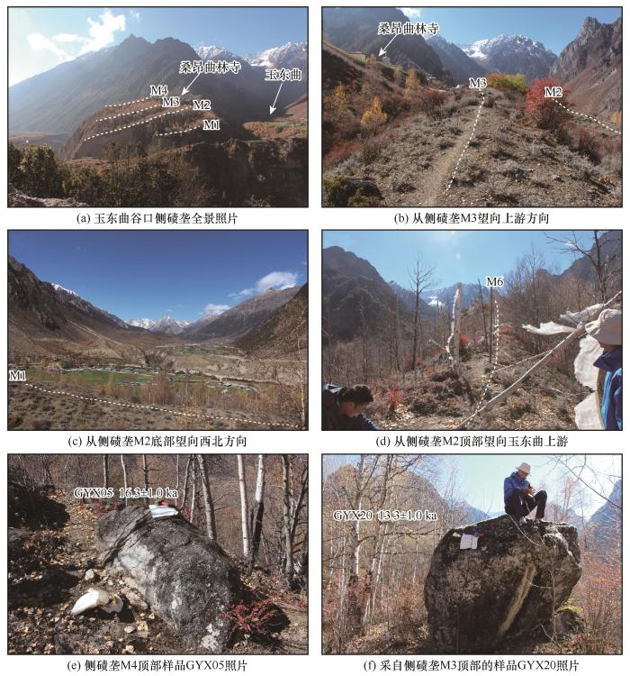

2.2 10Be暴露测年

本研究共采集14个花岗岩漂砾样品,样品选择时遵循以下原则和标准:(1)沿冰碛垄顶部选取多个具有一定埋深,出露地表高度不低于50 cm,且直径较大的漂砾,以减少后期地质地貌过程造成的漂砾倾倒或翻滚的可能37;(2)避免选择具有明显崩解或已有开裂现象的漂砾;(3)使用锤子和凿子从漂砾顶部较为平坦的部位凿取不少于500 g富含石英的岩石样品。采样时,从多个角度拍摄漂砾照片。利用手持GPS记录漂砾的地理位置信息和海拔高程,同时测量漂砾样品的尺寸。以上具体信息详见表1

表1   玉东曲样品详细信息(包括样品地理信息、尺寸、10Be加速器测量数据、10Be浓度和暴露年龄等)

Table 1  Sample details, 10Be data, and exposure-ages of granitic glacial boulders dated in the Yudongqu Valley

冰碛垄编号

样品

编号

纬度/N经度/E海拔/m漂砾尺寸(长/宽/高)/cm样品厚度/cm屏蔽系数a石英质量/gBe载体质量b/g10Be/9Be(10-15c10Be浓度/(105原子/每克石英)10Be暴露年龄与外部误差d/ka内部误差/ka
M3GYX1629.169533°97.179699°3 457110/100/901.30.989540.02030.3315994.52±40.575.47±0.2317.3±1.30.7
GYX1729.169645°97.179803°3 45370/55/501.50.983642.63680.32871 052.92±36.745.39±0.2017.2±1.20.6
GYX1829.168997°97.179496°3 463220/100/706.40.987449.38270.32811 116.40±41.184.93±0.1916.3±1.20.6
GYX1929.168692°97.179361°3 464128/96/551.10.985747.72450.32901 205.72±40.915.52±0.2017.4±1.20.6
GYX2029.168232°97.179280°3 465414/265/2523.40.987345.93090.3275845.14±39.773.99±0.1913.3±1.00.6
M4GYX0129.169075°97.180134°3 462190/90/752.60.991145.91020.32811 296.11±46.196.16±0.2319.3±1.40.7
GYX0229.169162°97.180279°3 461201/132/821.90.991850.72380.32651 119.55±13.474.79±0.0815.3±0.90.2
GYX0329.169162°97.180279°3 461133/106/723.90.991842.39930.32691 132.51±36.175.80±0.2018.5±1.30.6
GYX0429.169350°97.180388°3 465175/100/607.50.990649.31760.32821 184.85±38.155.24±0.1817.3±1.20.6
GYX0529.169490°97.180504°3 459210/130/1102.30.987154.54550.32651 262.17±15.415.02±0.0816.5±1.00.3
M5GYX0629.168282°97.180143°3 493210/170/2108.00.993043.78160.32971 151.99±37.365.76±0.2018.6±1.30.7
GYX0729.168237°97.180060°3 48655/50/503.10.993151.46380.32791 290.84±14.435.47±0.0817.2±1.10.3
M6GYX0929.168503°97.181150°3 474160/90/606.50.984226.20300.3325607.41±32.695.09±0.2816.7±1.40.9
GYX1029.168509°97.181154°3 474210/120/704.20.984246.51470.3207854.24±37.273.90±0.1813.1±1.00.6
Blank (空白样)0.32666.73±1.21

注:a 屏蔽系数利用Li45开发的Python程序在ArcGIS中计算所得,计算所采用的方位角和仰角均为5°。b9Be载体浓度为1 mg⋅g-1c 样品10Be与9Be比值为进行本底校正之前的数值。d 暴露年龄为CRONUS-Earth在线计算程序43中的LSDn产率模式44的计算结果。

新窗口打开| 下载CSV


样品前处理实验和加速器测试均在中国科学院地球环境研究所西安加速器质谱中心完成。样品切割粉碎后,筛取粒径为250~750 μm的组分,利用改进过的Kohl等38的前处理流程进行石英提纯39-40。此后,按照西安加速器质谱中心的化学处理流程41,从提纯的石英中提取Be并制备成BeO靶标。采用07KNSTD标准(10Be/9Be比值为2.851×10-1242进行加速器测试,并将所测得的10Be与9Be比值转化为石英中的10Be浓度,用于10Be暴露年龄的计算。

本文采用CRONUS-Earth在线计算程序v343http://hess.ess.washington.edu/)计算漂砾的暴露年龄。在后文的讨论中采用LSDn产率模型44提供的计算结果。计算所采用的岩石密度为2.65 g·cm-3,并假定侵蚀速率为0。对于来自周围地形遮蔽,利用屏蔽系数进行校正。屏蔽系数利用Li45开发的Python程序和30 m精度DEM在ArcGIS软件中计算所得。利用该程序计算屏蔽系数时所设定的方位角和仰角均为5°。计算时,未进行积雪覆盖和植被遮挡校正,因此所获得漂砾的暴露年龄为最小暴露年龄。

进行暴露测年的冰川漂砾可能受后期地质地貌过程影响,从而使所获得的暴露年龄小于其真实暴露年龄,也可能具有核素继承性从而使所获暴露年龄偏老46。为了减少前述所引起的异常值对定年的影响,对于采样数量不少于3个的冰碛垄,将在1σ内部误差范围内与其他年龄数据不重叠的作为异常值排除47-51。对于采样数量小于3的冰碛垄,以地貌相对新老关系为参考,对所获暴露年龄进行讨论。同时,利用累积概率密度曲线来判断每组暴露年龄的集中程度,辅以判断异常值的排除是否准确452-55。排除异常值后,通过简化卡方分析判断剩余年龄数据的集中程度是否仅仅取决于前处理实验和加速器测试:当P值大于0.05时,可认为暴露年龄之间的差异只来自于实验和加速器测试56-57

3 结果

3.1 冰碛垄序列

玉东曲谷口往上游方向至桑昂曲林寺1 km的范围内,共保存有6道近乎平行分布的残破侧碛垄[图2,图3(a)、3(d)]。按照地貌相对新老关系,我们将其从新到老依次命名为M1~M6(图2)。这些侧碛垄高度约为2~5 m,距离现代冰川末端约5~8 km。其中,长度最短(不到200 m)的侧碛垄M1海拔也最低,介于3 600~3 900 m,高出现代河面约30 m。冰碛垄顶部散布高度不超过1 m的灌木,其坡面至现代河床处则生长高约3米的乔木。该冰碛垄表面较难寻直径超过50 cm的冰川漂砾。侧碛垄M2高出M1约40 m,长约700 m,其顶部密布灌木和乔木等植被。该道侧碛垄同M1相似,表面几乎难以见到直径较大的冰川漂砾。冰碛垄M3比M2高约20 m,长度短约100 m。该侧碛垄顶部的灌木和乔木之间,随处可见直径超过1 m的花岗岩漂砾。其中,最大的漂砾直径可达4 m。漂砾表面通常发育有直径超过30 cm的苔藓,部分漂砾表面可见灰褐色岩漆面[图3(f)]。比冰碛垄M3高近10 m的M4,长度与其相近,而且冰碛垄表面的植被覆盖程度以及冰川漂砾的分布状况也非常相似。但是,漂砾表面发育的苔藓直径明显更大。

图3

图3   冰川地貌及部分漂砾样品照片

Fig. 3   Selective photographs showing glacial and associated landforms (a)~(d) as well as examples of sampled boulders for 10Be surface exposure dating (e) and (f): a panoramic photograph showing the lateral moraines identified near the valley-mouth (a); view upstream from the M3 moraine. White dashed line illustrates the M2 and M3 moraine. White arrow indicates the Sangangqulin temple (b); looking southwards from the lowest part of the M2 moraine. Shown in the foreground is the M1 moraine (c); looking upstream from the M6 moraine(d); boulder GYX05 presenting rock varnish on the surface (e); boulder (GYX20) that is sampled from the M3 moraine (f)
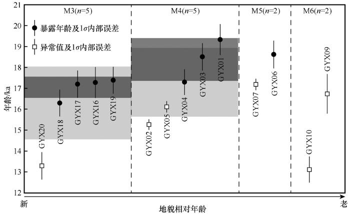

侧碛垄M5和M6高出M4约3~5 m,长度分别约为130 m和180 m。这两道冰碛垄表面人类后期活动和改造痕迹更为明显,随处可见经幡[图3(d)]。虽然植被覆盖情况与M4相似,但漂砾风化程度明显更为严重。

3.2 暴露测年结果及分析

采自4道侧碛垄(M3~M6)的14个冰川漂砾的10Be暴露年龄介于(13.3±1.0)~(19.3±1.4) ka(图2表1)。这些暴露年龄几乎全部对应末次冰消期,说明进行暴露测年研究的4道侧碛垄很可能反映了末次冰消期期间的冰川进退活动。其中,地貌上相对年轻的两道侧碛垄M3和M4的暴露年龄与其地貌相对年龄大致相符(图4)。下文对暴露测年结果做详细说明和解释。

图4

图4   冰碛垄M3~M6暴露年龄分布图(依据地貌从新到老关系依次排列,黑色圆圈代表10Be暴露年龄和1σ内部误差,白色长方形表示异常值;浅灰色横条带为排除异常值前的平均年龄,深灰色带为排除异常值后的平均年龄)

Fig. 4   Apparent 10Be exposure-ages plotted by relative moraine ages for the Yudongqu Valley [Exposure-ages are illustrated by black circles and open rectangles (potential outliers), next to which the sample ID is listed. The number of samples is shown for each moraine. The light grey-shaded boxes represent the mean age for moraine M3 and M4 (including the potential outliers). The dark grey-shaded boxes are the mean age without potential outliers]


采自冰碛垄M3的5个漂砾的暴露年龄分别为(13.3±1.0) ka、(16.3±1.2) ka、(17.2±1.2) ka、(17.3±1.3) ka和(17.4±1.2) ka。其中,最为年轻的暴露年龄与其他暴露年龄在1σ内部误差范围内不重叠(图4)。此外,累积概率密度曲线显示其余4个暴露年龄均紧密集中于17.2 ka左右[图5(a)]。因此,我们认为该组年代数据中的最小暴露年龄为异常值。就冰期测年研究而言,所获暴露年龄小于其真实暴露年龄的现象相较核素继承性更为普遍46。引发该现象的因素有很多,主要包括以下地质地貌过程:漂砾表面的侵蚀风化,冰碛垄沉积后演化过程中漂砾的翻滚、倾倒和后期暴露,以及积雪、沉积物和植被等的覆盖374658-64。考虑该漂砾(GYX20)直径和出露地表高度均较大,后期暴露的可能性很小;且该样品具有一定埋深,我们推测侵蚀风化可能是造成所测暴露年龄偏小的原因。将对应暴露年龄作为异常值排除后,剩余4个数据的平均值为(17.0±0.5) ka,简化卡方为0.6(P>0.05)。

图5

图5   冰碛垄M3~M6暴露年龄概率密度图(红色细线代表单个暴露年龄的概率密度;黑色粗线为排除异常值后剩余暴露年龄的累积概率密度)

Fig. 5   
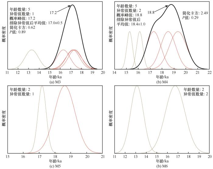
Probability distribution function (PDF) plots of 10Be exposure-ages for the M3~M6 moraines in the Yudongqu Valley (Thin red lines represent each individual exposure-age. Thin light grey lines indicate potential outliers. Thick black line is the summed probability of all exposure-ages after rejecting potential outliers)


从冰碛垄M4顶部所采集5个漂砾样品的10Be暴露年龄介于(15.3±0.9)~(19.3±1.4) ka(图2图4)。累积概率密度曲线显示其中3个样品(GYX01、GYX03和GYX04)的暴露年龄相对集中,而另外两个暴露年龄(GYX02和GYX05)相对年轻[图5(b)]。这两个暴露年龄在1σ内部误差范围内与其余暴露年龄不重叠。且从地貌相对新老关系考虑,冰碛垄M4沉积时代应早于M3,这进一步证明这两个暴露年轻样品可能受到后期地质地貌过程的影响。因此,我们将这两个样品作为异常值排除,剩余3个年龄数据的平均值为(18.4±1.0) ka,简化卡方为2.49(P>0.05)。

从地貌相对新老关系上判断,冰碛垄M5和M6具有更早的沉积时代。从这两道冰碛垄上共获得了4个冰川漂砾样品。这些样品的暴露年龄相较在M3和M4所获得的漂砾而言,时代偏年轻(图2图4)。即,M5和M6所测4个暴露年龄极有可能小于它们的真实暴露年龄。冰碛垄M5上样品GYX06的暴露年龄(18.6±1.3) ka与暂定的M4的形成时代[(18.4±1.0) ka]在误差范围内相重叠。考虑南北半球多个地点的山地冰川在LGM结束前后曾发生过多次千-百年时间尺度的进退活动14-16,本文中未将该年龄数据作为异常值排除。然而,仅剩的1个暴露年龄无法达到准确限定冰碛垄形成时代的要求11-1265-66,因此目前无法确定冰碛垄M5的沉积时代。

综上所述,虽然部分10Be暴露年龄较为分散,且地貌上最老的两道冰碛垄(M5和M6)的形成时代无法确定,但是冰碛垄M3和M4的形成时代被分别限定为于(17.0±0.5) ka和(18.4±1.0) ka。

4 讨论

4.1 玉东曲千-百年尺度冰川波动

地貌调查、制图和暴露测年结果显示:LGM结束时,布噶岗日玉东曲流域内的冰川至少发生过两次进退活动,其时代分别为(17.0±0.5) ka和(18.4±1.0) ka。换言之,该地点在LGM结束前后曾发生过至少两次千-百年尺度冰川波动:其中,M4所对应的冰川进退可能发生于LGM后期或LGM结束后,而M3对应的冰川波动则对应于末次冰消期。这两次冰川进退事件的时代可与青藏高原其他地点相比较。

全球LGM的结束,即末次冰消期的开始早已成为第四纪冰川研究的重点内容之一4,且南北半球中低纬度山地冰川在该时期的进退均已有相关报道515-1667。就青藏高原及其周边山地而言,针对末次冰消期起始时间而开展的暴露测年研究并不多见。但冰川对于海因里希(Heinrich)事件1(H1)的响应已在不同气候区的多个地点得到证实:如,与玉东曲同处亚洲夏季风影响区的海子山68和巴松措69,地处中纬度西风控制区的慕士塔格70和罕萨山谷71,以及位于这两种大气环流交互作用区的青藏高原中部的甲岗峰21等。这些地点已报道的冰川进退时代大致在17~18 ka,可与玉东曲冰碛垄M3的时代相对应。

LGM结束前后,即19 ka左右青藏高原冰川作用时代较为确切的研究亦不是很多。但不同气候区多个地点均有该时期冰川波动的报道:如,亚洲夏季风区的帕隆藏布谷地内,距离玉东曲西北约190 km的白玉冰期冰碛垄最老10Be暴露年龄为18.5 ka72;西风作用区的塔什库尔干地区多道冰碛垄的年代为18~24 ka4873;亚洲夏季风和西风交互作用区的念青唐古拉山西段琼木曲谷口附近的内侧冰碛垄时代为(20.4±0.7) ka52。虽然上述地点没有更多有绝对年龄限定的冰川作用序列可作参考,但这些冰川活动的时代可与本文玉东曲M4的时代大致对应。这表明青藏高原不同气候区的冰川在LGM结束前后均曾发生过进退活动。

虽然未能对M1和M2进行暴露测年,且M5和M6的暴露年龄多为异常值,但是这几道冰碛垄的形态特征与M3和M4高度相似,起伏不大。从地貌上看,应同为玉东曲内的冰川对短尺度(如千-百年尺度)气候突变事件响应的结果。由此可推断玉东曲末次冰消期还可能发生过两次千-百年尺度冰川波动。这一推测与Xu等74在念青唐古拉山西段帕戈勒沟报道的多道末次冰消期冰碛垄类似。

4.2 玉东曲末次冰消期冰川变化的气候驱动机制

众所周知,冰川的进退主要受控于气温和降水75。这两个因素对冰川进退的贡献在不同时空尺度下又是变化的76,因此确定哪一因素在冰川进退中起决定性作用一直是第四纪冰川研究的难题之一。青藏高原及其周边地区冰川变化的气候驱动机制研究主要针对北半球高纬夏季太阳辐射和亚洲夏季风降水来展开讨论25。在此,我们针对这两大气候要素与玉东曲两次冰川波动的关系来进行讨论。

米兰科维奇理论认为第四纪冰期-间冰期旋回由北半球高纬夏季太阳辐射所驱动。因此,北半球高纬夏季太阳辐射强度变化通常也被认为是青藏高原冰川变化的主要诱因。就LGM而言,北半球夏季太阳辐射强度在23 ka左右达到最低值,此后便逐渐增强77图6(c)]。而由海平面变化78所反映的全球冰量变化也的确与之相对应[图6(b)]。然而仅仅是北半球夏季太阳辐射强度这一因素,显然难以解释玉东曲流域内的千-百年尺度冰川波动。

图6

图6   玉东曲末次冰消期冰川变化与气候记录对比

Fig. 6   
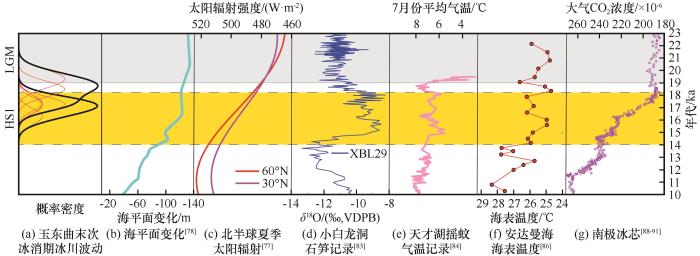
Climatic records relative to 10Be-based moraine chronologies in the Yudongqu Valley. The yellow band corresponds with Heinrich Stadial 1 (HS1). The light grey band indicates part of the global LGM: probability density function (PDF) plot of the glacial culminations in the Yudongqu Valley. Thin red lines show PDF for individual samples with potential outliers excluded. Thick black lines represent the cumulative probability distribution of the boulder age population (a); ice-volume equivalent sea level78 (b); Northern Hemisphere summer solar insolation intensity at high and local latitudes77 (c); the stalagmite δ18O record from Xiaobailong Cave, southern HDM83 (d); chironomid-inferred mean July temperature record from Lake Tiancai84 (e); SSTs reconstructed from Andaman Sea core RC12-34486 (f); synthesized atmospheric CO2 concentrations in Antarctic ice cores88-91 (g)


亚洲夏季风降水驱动青藏高原冰川变化的观点,大致始于本世纪初深海氧同位素3阶段(marine isotope stage 3, MIS3)冰进的发现79-80。此后,MIS3冰进在青藏高原多个地点被频繁报道81-82。MIS3较为丰富的降水配合该时期相对较低的气温致使冰川规模大于气候更为干冷的LGM时期。玉东曲降水主要来自于印度夏季风,小白龙洞石笋δ18O记录显示:19~15 ka期间印度夏季风强度虽然存在多次波动,但总体呈现逐渐减弱的趋势,且强度弱于LGM时期83图6(d)],不可能是该时期冰川波动的主因。天才湖摇蚊记录显示横断山脉7月份平均气温在19~16 ka存在两次幅度约为1.0~1.5 ℃的冷暖交替事件84图6(e)]。考虑玉东曲及其附近的冰川属于海洋型冰川,积累和消融均发生在夏季85。这两次明显的降温事件应该是该时期玉东曲冰川发生短暂停顿的原因,从而形成了冰碛垄M3和M4。

该区夏季气温84与印度洋-太平洋暖池(Indo-Pacific Warm Pool, IPWP)海表温度(sea surface temperature, SST)86具有很好的相关性[图6(d), 6(e)]。说明IPWP中SST变化的信号可以通过西风带传递到青藏高原87,从而引发岗日嘎布玉东曲的冰川进退。IPWP中SST的变化被认为取决于大西洋经向翻转环流的(Atlantic meridional overturning circulation, AMOC)强弱,AMOC又与北半球冰盖的消长息息相关3:23 ka时北半球冰盖开始部分消融,浮冰和淡水注入北大西洋引发AMOC减弱;减弱的AMOC使洋流从低纬向高纬传输热量减少,从而引发IPWP的SST升高;18 ka时北半球冰盖大量消融,上述过程加强,AMOC中断,大量CO2从深海释放,大气CO2浓度急剧升高88-91图6(g)],加强了上述过程。但对于其触发因子却存在两种主要观点:一种认为北半球高纬夏季太阳辐射23 ka时升高驱动冰盖消融3,另一种观点则认为南半球中纬度西风带位置的移动导致海-气热量传递的改变从而引发冰盖消融5。无论是哪一种机制触发了北半球冰盖的消融,由此引发的海-陆-气相互作用都会引起青藏高原山地冰川在该时期发生进退。

5 结论

本文通过对青藏高原东南部岗日嘎布玉东曲谷口沉积的6道侧碛垄中地貌相对年龄较老的4道进行宇宙成因核素10Be暴露测年,首次专门针对青藏高原末次冰消期千-百年尺度冰川演化进行了精细化定年研究。采自这4道冰碛垄的14个冰川漂砾样品的10Be暴露年龄介于(13.3±1.0)~(19.3±1.4) ka。本研究为该区和整个青藏高原第四纪冰期年代学增添了新的精确定年数据。经过统计分析排除异常值后,地貌相对年龄较新的两道侧碛垄的形成时代被分别被限定为(17.0±0.5) ka和(18.4±1.0) ka。这说明这两道冰碛垄对应的冰川活动发生在末次冰消期或LGM晚期。通过与气候记录对比发现,这两次冰川进退事件与该区受控于IPWP的SST变化的夏季气温紧密相关。

参考文献

Clark P UDyke A SShakun J Det al.

The Last Glacial Maximum

[J]. Science, 20093255941): 710-714.

[本文引用: 1]

Cheng HaiEdwards R LBroecker W Set al.

Ice age terminations

[J]. Science, 20093265950): 248-252.

[本文引用: 1]

Denton G HAnderson R FToggweiler J Ret al.

The last glacial termination

[J]. Science, 20103285986): 1652-1656.

[本文引用: 3]

Schaefer J MDenton G HBarrell D J Aet al.

Near-synchronous interhemispheric termination of the Last Glacial Maximum in mid-latitudes

[J]. Science, 20063125779): 1510-1513.

[本文引用: 5]

Denton G HPutnam A ERussell J Let al.

The Zealandia Switch: Ice age climate shifts viewed from Southern Hemisphere moraines

[J]. Quaternary Science Reviews, 2021257106771.

[本文引用: 5]

He FengShakun J DClark P Uet al.

Northern Hemisphere forcing of Southern Hemisphere climate during the last deglaciation

[J]. Nature, 20134947435): 81-85.

[本文引用: 1]

Wolff E WFischer HFundel Fet al.

Southern Ocean sea-ice extent, productivity and iron flux over the past eight glacial cycles

[J]. Nature, 20064407083): 491-496.

[本文引用: 1]

Shi Yafeng. Glaciers and Their Environments in China[M]. BeijingScience Press2000.

[本文引用: 1]

施雅风. 中国冰川与环境: 现在、过去和未来[M]. 北京科学出版社2000.

[本文引用: 1]

Oerlemans J.

Extracting a climate signal from 169 glacier records

[J]. Science, 20053085722): 675-677.

[本文引用: 1]

Benn DEvans D J A. Glaciers and Glaciation[M]. 2nd edition. LondonRoutledge2014.

[本文引用: 1]

Balco G.

Contributions and unrealized potential contributions of cosmogenic-nuclide exposure dating to glacier chronology, 1990—2010

[J]. Quaternary Science Reviews, 2011301/2): 3-27.

[本文引用: 2]

Balco G.

Glacier change and paleoclimate applications of cosmogenic-nuclide exposure dating

[J]. Annual Review of Earth and Planetary Sciences, 20204821-48.

[本文引用: 2]

Jackson M SKelly M ARussell J Met al.

High-latitude warming initiated the onset of the last deglaciation in the tropics

[J]. Science Advances, 2019512): eaaw2610.

[本文引用: 1]

Palacios DStokes C RPhillips F Met al.

The deglaciation of the Americas during the Last Glacial Termination

[J]. Earth-Science Reviews, 2020203103113.

[本文引用: 2]

Strand P DPutnam A ESambuu Oet al.

A 10Be Moraine Chronology of the last glaciation and termination at 49° N in the Mongolian Altai of Central Asia

[J]. Paleoceanography and Paleoclimatology, 2022375): e2022PA004423.

[本文引用: 1]

Strand P DSchaefer J MPutnam A Eet al.

Millennial-scale pulsebeat of glaciation in the Southern Alps of New Zealand

[J]. Quaternary Science Reviews, 2019220165-177.

[本文引用: 3]

Shakun J DClark P UHe Fenget al.

Regional and global forcing of glacier retreat during the last deglaciation

[J]. Nature Communications, 201568059.

[本文引用: 4]

Peltier CKaplan M RBirkel S Det al.

The large MIS 4 and long MIS 2 glacier maxima on the southern tip of South America

[J]. Quaternary Science Reviews, 2021262106858.

[本文引用: 1]

Tulenko J PBriner J PYoung N Eet al.

Beryllium-10 chronology of early and late Wisconsinan moraines in the Revelation Mountains, Alaska: Insights into the forcing of Wisconsinan glaciation in Beringia

[J]. Quaternary Science Reviews, 2018197129-141.

[本文引用: 1]

Anderson R FAli SBradtmiller L Iet al.

Wind-driven upwelling in the Southern Ocean and the deglacial rise in atmospheric CO2

[J]. Science, 20093235920): 1443-1448.

[本文引用: 1]

Dong GuochengZhou WeijianYi Chaoluet al.

The timing and cause of glacial activity during the last glacial in central Tibet based on 10Be surface exposure dating east of Mount Jaggang, the Xainza range

[J]. Quaternary Science Reviews, 2018186284-297.

[本文引用: 2]

Saha SOwen L AOrr E Net al.

High-frequency Holocene glacier fluctuations in the Himalayan-Tibetan orogen

[J]. Quaternary Science Reviews, 2019220372-400.

[本文引用: 1]

Heyman JStroeven A PCaffee M Wet al.

Palaeoglaciology of Bayan Har Shan, NE Tibetan Plateau: exposure ages reveal a missing LGM expansion

[J]. Quaternary Science Reviews, 20113015/16): 1988-2001.

[本文引用: 1]

Dong GuochengYi ChaoluZhou Weijianet al.

Late Quaternary glacial history of the Altyn Tagh Range, northern Tibetan Plateau

[J]. Palaeogeography, Palaeoclimatology, Palaeoecology, 2021577110561.

[本文引用: 1]

Owen L ADortch J M.

Nature and timing of Quaternary glaciation in the Himalayan-Tibetan orogen

[J]. Quaternary Science Reviews, 20148814-54.

[本文引用: 2]

Xu ZongxueZhang LingHuang Junxionget al.

Long-term trend of temperature, precipitation and relative humidity in the Tibetan region

[J]. Meteorological Monthly, 2007337): 82-88.

[本文引用: 1]

徐宗学张玲黄俊雄.

西藏地区气温、降水及相对湿度的趋势分析

[J]. 气象, 2007337): 82-88.

[本文引用: 1]

Shi YafengLiu Shiyin.

Estimation on the response of glaciers in China to the global warming in the 21st century

[J]. Chinese Science Bulletin, 2000457): 668-672.

[本文引用: 1]

Li JijunZheng BenxingYang Xijinet al. Glaciers in Tibet[M]. BeijingScience Press1986140-148.

[本文引用: 1]

李吉均郑本兴杨锡金. 西藏冰川[M]. 北京科学出版社1986140-148.

[本文引用: 1]

Mi DeshengXie ZichuFeng Qinghuaet al. Glacier inventory of China, XI, the Gangga drainage basin[M]. Xi’anXi’an Cartographic Publishing House2002.

[本文引用: 1]

米德生谢自楚冯清华. 中国冰川编目XI, 恒河水西[M]. 西安西安地图出版社2002.

[本文引用: 1]

Liu ShiyinShangguan DonghuiDing Yongjianet al.

Glacier variations since the early 20th century in the Gangrigabu Range, southeast Tibetan Plateau

[J]. Journal of Glaciology and Geocryology, 2005271): 55-63.

[本文引用: 1]

刘时银上官冬辉丁永建.

20世纪初以来青藏高原东南部岗日嘎布山的冰川变化

[J]. 冰川冻土, 2005271): 55-63.

[本文引用: 1]

Blomdin RHeyman JStroeven A Pet al.

Glacial geomorphology of the Altai and Western Sayan Mountains, Central Asia

[J]. Journal of Maps, 2016121): 123-136.

[本文引用: 1]

Fu PingHeyman JHättestrand Cet al.

Glacial geomorphology of the Shaluli Shan area, southeastern Tibetan Plateau

[J]. Journal of Maps, 201281): 48-55.

Fu PingStroeven A PHarbor J Met al.

Paleoglaciation of Shaluli Shan, southeastern Tibetan Plateau

[J]. Quaternary Science Reviews, 201364121-135.

Heyman JHättestrand CStroeven A P.

Glacial geomorphology of the Bayan Har sector of the NE Tibetan Plateau

[J]. Journal of Maps, 200841): 42-62.

Morén BHeyman JStroeven A P.

Glacial geomorphology of the central Tibetan Plateau

[J]. Journal of Maps, 201171): 115-125.

Stroeven A PHättestrand CHeyman Jet al.

Glacial geomorphology of the Tian Shan

[J]. Journal of Maps, 201394): 505-512.

[本文引用: 1]

Heyman JApplegate P JBlomdin Ret al.

Boulder height - exposure age relationships from a global glacial 10Be compilation

[J]. Quaternary Geochronology, 2016341-11.

[本文引用: 2]

Kohl C PNishiizumi K.

Chemical isolation of quartz for measurement of in-situ-produced cosmogenic nuclides

[J]. Geochimica et Cosmochimica Acta, 1992569): 3583-3587.

[本文引用: 1]

Dong GuochengYi ChaoluCaffee M.

~10Be dating of boulders on moraines from the last glacial period in the Nyainqentanglha mountains, Tibet

[J]. Science China Earth Sciences, 2014572): 221-231.

[本文引用: 1]

Dortch J MOwen L AHaneberg W Cet al.

Nature and timing of large landslides in the Himalaya and Transhimalaya of northern India

[J]. Quaternary Science Reviews, 20092811/12): 1037-1054.

[本文引用: 1]

Zhang LiWu ZhenkunChang Honget al.

A case study using 10Be-26Al exposure dating at the Xi’an AMS center

[J]. Radiocarbon, 2016581): 193-203.

[本文引用: 1]

Nishiizumi KImamura MCaffee M Wet al.

Absolute calibration of 10Be AMS standards

[J]. Nuclear Instruments and Methods in Physics Research Section B: Beam Interactions with Materials and Atoms, 20072582): 403-413.

[本文引用: 1]

Balco GStone J OLifton N Aet al.

A complete and easily accessible means of calculating surface exposure ages or erosion rates from 10Be and 26Al measurements

[J]. Quaternary Geochronology, 200833): 174-195.

[本文引用: 2]

Lifton NSato TDunai T J.

Scaling in situ cosmogenic nuclide production rates using analytical approximations to atmospheric cosmic-ray fluxes

[J]. Earth and Planetary Science Letters, 2014386149-160.

[本文引用: 2]

Li Yingkui.

Determining topographic shielding from digital elevation models for cosmogenic nuclide analysis: a GIS approach and field validation

[J]. Journal of Mountain Science, 2013103): 355-362.

[本文引用: 2]

Heyman JStroeven A PHarbor J Met al.

Too young or too old: evaluating cosmogenic exposure dating based on an analysis of compiled boulder exposure ages

[J]. Earth and Planetary Science Letters, 20113021/2): 71-80.

[本文引用: 3]

Chevalier M LHilley GTapponnier Pet al.

Constraints on the late Quaternary glaciations in Tibet from cosmogenic exposure ages of moraine surfaces

[J]. Quaternary Science Reviews, 2011305/6): 528-554.

[本文引用: 1]

Xu XiangkeHu GangQiao Baojin.

Last glacial maximum climate based on cosmogenic 10Be exposure ages and glacier modeling for the head of Tashkurgan Valley, northwest Tibetan Plateau

[J]. Quaternary Science Reviews, 20138091-101.

[本文引用: 1]

Xu XiangkeYi Chaolu.

Little Ice Age on the Tibetan Plateau and its bordering mountains: evidence from moraine chronologies

[J]. Global and Planetary Change, 201411641-53.

Zhang QianYi ChaoluDong Guochenget al.

Quaternary glaciations in the Lopu Kangri area, central Gangdise Mountains, southern Tibetan Plateau

[J]. Quaternary Science Reviews, 2018201470-482.

Peng XuChen YixinLi Yingkuiet al.

Late Holocene glacier fluctuations in the Bhutanese Himalaya

[J]. Global and Planetary Change, 2020187103137.

[本文引用: 1]

Dong GuochengXu XiangkeZhou Weijianet al.

Cosmogenic 10Be surface exposure dating and glacier reconstruction for the Last Glacial Maximum in the Quemuqu Valley, western Nyainqentanglha Mountains, south Tibet

[J]. Journal of Quaternary Science, 2017325): 639-652.

[本文引用: 2]

Dong GZhou WeijianYi Cet al.

Cosmogenic 10Be surface exposure dating of ‘Little Ice Age’ glacial events in the Mount Jaggang area, central Tibet

[J]. The Holocene, 2017271516-1525.

Peng XuChen YixinLiu Gengnianet al.

Late quaternary glaciations in the Cogarbu valley, Bhutanese Himalaya

[J]. Journal of Quaternary Science, 2019341): 40-50.

Schaefer J MDenton G HKaplan Met al.

High-frequency Holocene glacier fluctuations in New Zealand differ from the northern signature

[J]. Science, 20093245927): 622-625.

[本文引用: 1]

Chen YixinLi YingkuiWang Yueyanet al.

Late Quaternary glacial history of the Karlik Range, easternmost Tian Shan, derived from 10Be surface exposure and optically stimulated luminescence datings

[J]. Quaternary Science Reviews, 201511517-27.

[本文引用: 1]

Li YingkuiLiu GengnianChen Yixinet al.

Timing and extent of Quaternary glaciations in the Tianger Range, eastern Tian Shan, China, investigated using 10Be surface exposure dating

[J]. Quaternary Science Reviews, 2014987-23.

[本文引用: 1]

Applegate P JUrban N MKeller Ket al.

Improved moraine age interpretations through explicit matching of geomorphic process models to cosmogenic nuclide measurements from single landforms

[J]. Quaternary Research, 2012772): 293-304.

[本文引用: 1]

Applegate P JUrban N MLaabs B J Cet al.

Modeling the statistical distributions of cosmogenic exposure dates from moraines

[J]. Geoscientific Model Development, 201031): 293-307.

Dortch J MOwen L ACaffee M W.

Timing and climatic drivers for glaciation across semi-arid western Himalayan-Tibetan orogen

[J]. Quaternary Science Reviews, 201378188-208.

Hallet BPutkonen J.

Surface dating of dynamic landforms: Young boulders on aging moraines

[J]. Science, 19942655174): 937-940.

Putkonen JO’Neal M.

Degradation of unconsolidated quaternary landforms in the western North America

[J]. Geomorphology, 2006753/4): 408-419.

Putkonen JSwanson T.

Accuracy of cosmogenic ages for moraines

[J]. Quaternary Research, 2003592): 255-261.

Zech RGlaser BSosin Pet al.

Evidence for long-lasting landform surface instability on hummocky moraines in the Pamir Mountains (Tajikistan) from 10Be surface exposure dating

[J]. Earth and Planetary Science Letters, 20052373/4): 453-461.

[本文引用: 1]

Blomdin RStroeven A PHarbor J Met al.

Timing and dynamics of glaciation in the Ikh Turgen Mountains, Altai region, High Asia

[J]. Quaternary Geochronology, 20184754-71.

[本文引用: 1]

Heyman J.

Paleoglaciation of the Tibetan Plateau and surrounding mountains based on exposure ages and ELA depression estimates

[J]. Quaternary Science Reviews, 20149130-41.

[本文引用: 1]

Putnam A ESchaefer J MDenton G Het al.

Warming and glacier recession in the Rakaia valley, Southern Alps of New Zealand, during Heinrich Stadial 1

[J]. Earth and Planetary Science Letters, 201338298-110.

[本文引用: 1]

Schäfer J MTschudi SZhao Zhizhonget al.

The limited influence of glaciations in Tibet on global climate over the past 170 000 yr

[J]. Earth and Planetary Science Letters, 20021943/4): 287-297.

[本文引用: 1]

Hu GangYi ChaoluZhang Jiafuet al.

Extensive glacial advances during the Last Glacial Maximum near the eastern Himalayan syntaxis

[J]. Quaternary International, 20174431-12.

[本文引用: 1]

Seong Y BOwen L AYi Chaoluet al.

Quaternary glaciation of Muztag Ata and Kongur Shan: Evidence for glacier response to rapid climate changes throughout the Late Glacial and Holocene in westernmost Tibet

[J]. Geological Society of America Bulletin, 20091213/4): 348-365.

[本文引用: 1]

Owen L AFinkel R CCaffee M Wet al.

Timing of multiple late Quaternary glaciations in the Hunza Valley, Karakoram Mountains, northern Pakistan: defined by cosmogenic radionuclide dating of moraines

[J]. Geological Society of America Bulletin, 20021145): 593-604.

[本文引用: 1]

Zhou ShangzheXu LiubingColgan P Met al.

Cosmogenic ~10Be dating of Guxiang and Baiyu glaciations

[J]. Chinese Science Bulletin, 20075210): 1387-1393.

[本文引用: 1]

Owen L AChen JieHedrick K Aet al.

Quaternary glaciation of the Tashkurgan valley, southeast Pamir

[J]. Quaternary Science Reviews, 20124756-72.

[本文引用: 1]

Xu XiangkeYao TandongXu Baiqinget al.

Glacial events during the last glacial termination in the Pagele valley, Qiongmu Gangri peak, southern Tibetan Plateau, and their links to oceanic and atmospheric circulation

[J]. Quaternary Research, 202095129-141.

[本文引用: 1]

Rupper SRoe GGillespie A.

Spatial patterns of Holocene glacier advance and retreat in Central Asia

[J]. Quaternary Research, 2009723): 337-346.

[本文引用: 1]

Benn D IOwen L A.

The role of the Indian summer monsoon and the mid-latitude westerlies in Himalayan glaciation: review and speculative discussion

[J]. Journal of the Geological Society, 19981552): 353-363.

[本文引用: 1]

Berger ALoutre M F.

Insolation values for the climate of the last 10 million years

[J]. Quaternary Science Reviews, 1991104): 297-317.

[本文引用: 2]

Lambeck KRouby HPurcell Aet al.

Sea level and global ice volumes from the Last Glacial Maximum to the Holocene

[J]. Proceedings of the National Academy of Sciences of the United States of America, 201411143): 15296-15303.

[本文引用: 2]

Owen L AFinkel R CCaffee M W.

A note on the extent of glaciation throughout the Himalaya during the global Last Glacial Maximum

[J]. Quaternary Science Reviews, 2002211/2/3): 147-157.

[本文引用: 1]

Shi YafengYao Tandong.

MIS 3b (54-44 ka BP) cold period and glacial advance in middle and low latitudes

[J]. Journal of Glaciolgy and Geocryology, 2002241): 1-9.

[本文引用: 1]

施雅风姚檀栋.

中低纬度MIS 3b(54~44 ka BP)冷期与冰川前进

[J]. 冰川冻土, 2002241): 1-9.

[本文引用: 1]

Wang Jie.

Glacial advance in the Qinghai-Tibet Plateau and peripheral mountains during the mid-MIS 3

[J]. Quaternary Sciences, 2010305): 1055-1065.

[本文引用: 1]

王杰.

青藏高原及周边地区MIS 3中期冰进探讨

[J]. 第四纪研究, 2010305): 1055-1065.

[本文引用: 1]

Zhao JingdongZhou ShangzheLiu Shiyinet al.

A preliminary study of the glacier advance in MIS3b in the western regions of China

[J]. Journal of Glaciology and Geocryology, 2007292): 233-241.

[本文引用: 1]

赵井东周尚哲刘时银.

中国西部山岳冰川MIS3b冰进的初步探讨

[J]. 冰川冻土, 2007292): 233-241.

[本文引用: 1]

Cai YanjunFung I YEdwards R Let al.

Variability of stalagmite-inferred Indian monsoon precipitation over the past 252, 000 y

[J]. Proceedings of the National Academy of Sciences of the United States of America, 201511210): 2954-2959.

[本文引用: 2]

Zhang EnlouChang JieShulmeister Jet al.

Summer temperature fluctuations in Southwestern China during the end of the LGM and the last deglaciation

[J]. Earth and Planetary Science Letters, 201950978-87.

[本文引用: 3]

Wang WeicaiYao TandongYang Xiaoxin.

Variations of glacial lakes and glaciers in the Boshula Mountain range, southeast Tibet, from the 1970s to 2009

[J]. Annals of Glaciology, 20115258): 9-17.

[本文引用: 1]

Rashid HFlower B PPoore R Zet al.

A ∼25 ka Indian Ocean monsoon variability record from the Andaman Sea

[J]. Quaternary Science Reviews, 20072619/20/21): 2586-2597.

[本文引用: 2]

Wang ChenghaiYu LianHuang Bo.

The impact of warm pool SST and general circulation on increased temperature over the Tibetan Plateau

[J]. Advances in Atmospheric Sciences, 2012292): 274-284.

[本文引用: 1]

Ahn JBrook E J.

Atmospheric CO2 and climate on millennial time scales during the last glacial period

[J]. Science, 20083225898): 83-85.

[本文引用: 2]

Indermühle AStocker T FJoos Fet al.

Holocene carbon-cycle dynamics based on CO2 trapped in ice at Taylor Dome, Antarctica

[J]. Nature, 19993986723): 121-126.

Indermühle AMonnin EStauffer Bet al.

Atmospheric CO2 concentration from 60 to 20 kyr BP from the Taylor Dome ice core, Antarctica

[J]. Geophysical Research Letters, 2000275): 735-738.

Monnin EIndermühle ADallenbach Aet al.

Atmospheric CO2 concentrations over the last glacial termination

[J]. Science, 20012915501): 112-114.

[本文引用: 2]

/