State of the global climate 2020
1
... 全球气候变化是当今世界各国关注的焦点问题,世界气象组织(World Meteorological Organization, WMO)在《2020年全球气候状况报告》中指出,2020年全球气候变化进一步恶化,随着全球气温的升高、冰川融化退缩、海平面上升,对社会经济发展及生态系统造成严重影响[1].冰川作为其重要指标器,是全球气候变化的研究热点[2].冰川消融不仅会造成海平面上升,而且会在内陆引起冰崩、冰湖溃决等灾害,这对区域生态环境以及人类社会生活均会造成巨大影响[3],因而实时监测冰川范围变化具有重要意义[4].冰川范围监测的传统研究方法需要进行野外考察,外业调查的方法对冰川局部范围变化的精确分析具有一定优势,但存在监测范围较小、耗时费力等问题.遥感数据具有时间连续,空间覆盖广,数据获取方便等特点,基于遥感数据监测冰川一定程度上弥补了传统方法的不足[5]. ...
Data reduction using statistical and regression approaches for ice velocity derived by Landsat-8, Sentinel-1 and Sentinel-2
1
2020
... 全球气候变化是当今世界各国关注的焦点问题,世界气象组织(World Meteorological Organization, WMO)在《2020年全球气候状况报告》中指出,2020年全球气候变化进一步恶化,随着全球气温的升高、冰川融化退缩、海平面上升,对社会经济发展及生态系统造成严重影响[1].冰川作为其重要指标器,是全球气候变化的研究热点[2].冰川消融不仅会造成海平面上升,而且会在内陆引起冰崩、冰湖溃决等灾害,这对区域生态环境以及人类社会生活均会造成巨大影响[3],因而实时监测冰川范围变化具有重要意义[4].冰川范围监测的传统研究方法需要进行野外考察,外业调查的方法对冰川局部范围变化的精确分析具有一定优势,但存在监测范围较小、耗时费力等问题.遥感数据具有时间连续,空间覆盖广,数据获取方便等特点,基于遥感数据监测冰川一定程度上弥补了传统方法的不足[5]. ...
Analysis of runoff change and its influencing factors in Yanggong River basin of Yulong Snow Mountain under the background of climate change
1
2019
... 全球气候变化是当今世界各国关注的焦点问题,世界气象组织(World Meteorological Organization, WMO)在《2020年全球气候状况报告》中指出,2020年全球气候变化进一步恶化,随着全球气温的升高、冰川融化退缩、海平面上升,对社会经济发展及生态系统造成严重影响[1].冰川作为其重要指标器,是全球气候变化的研究热点[2].冰川消融不仅会造成海平面上升,而且会在内陆引起冰崩、冰湖溃决等灾害,这对区域生态环境以及人类社会生活均会造成巨大影响[3],因而实时监测冰川范围变化具有重要意义[4].冰川范围监测的传统研究方法需要进行野外考察,外业调查的方法对冰川局部范围变化的精确分析具有一定优势,但存在监测范围较小、耗时费力等问题.遥感数据具有时间连续,空间覆盖广,数据获取方便等特点,基于遥感数据监测冰川一定程度上弥补了传统方法的不足[5]. ...
气候变化背景下玉龙雪山漾弓江流域径流变化及其影响因素分析
1
2019
... 全球气候变化是当今世界各国关注的焦点问题,世界气象组织(World Meteorological Organization, WMO)在《2020年全球气候状况报告》中指出,2020年全球气候变化进一步恶化,随着全球气温的升高、冰川融化退缩、海平面上升,对社会经济发展及生态系统造成严重影响[1].冰川作为其重要指标器,是全球气候变化的研究热点[2].冰川消融不仅会造成海平面上升,而且会在内陆引起冰崩、冰湖溃决等灾害,这对区域生态环境以及人类社会生活均会造成巨大影响[3],因而实时监测冰川范围变化具有重要意义[4].冰川范围监测的传统研究方法需要进行野外考察,外业调查的方法对冰川局部范围变化的精确分析具有一定优势,但存在监测范围较小、耗时费力等问题.遥感数据具有时间连续,空间覆盖广,数据获取方便等特点,基于遥感数据监测冰川一定程度上弥补了传统方法的不足[5]. ...
An inventory of glacier changes for the Geladandong Mountain area, China
1
2015
... 全球气候变化是当今世界各国关注的焦点问题,世界气象组织(World Meteorological Organization, WMO)在《2020年全球气候状况报告》中指出,2020年全球气候变化进一步恶化,随着全球气温的升高、冰川融化退缩、海平面上升,对社会经济发展及生态系统造成严重影响[1].冰川作为其重要指标器,是全球气候变化的研究热点[2].冰川消融不仅会造成海平面上升,而且会在内陆引起冰崩、冰湖溃决等灾害,这对区域生态环境以及人类社会生活均会造成巨大影响[3],因而实时监测冰川范围变化具有重要意义[4].冰川范围监测的传统研究方法需要进行野外考察,外业调查的方法对冰川局部范围变化的精确分析具有一定优势,但存在监测范围较小、耗时费力等问题.遥感数据具有时间连续,空间覆盖广,数据获取方便等特点,基于遥感数据监测冰川一定程度上弥补了传统方法的不足[5]. ...
各拉丹冬区域冰川变化研究
1
2015
... 全球气候变化是当今世界各国关注的焦点问题,世界气象组织(World Meteorological Organization, WMO)在《2020年全球气候状况报告》中指出,2020年全球气候变化进一步恶化,随着全球气温的升高、冰川融化退缩、海平面上升,对社会经济发展及生态系统造成严重影响[1].冰川作为其重要指标器,是全球气候变化的研究热点[2].冰川消融不仅会造成海平面上升,而且会在内陆引起冰崩、冰湖溃决等灾害,这对区域生态环境以及人类社会生活均会造成巨大影响[3],因而实时监测冰川范围变化具有重要意义[4].冰川范围监测的传统研究方法需要进行野外考察,外业调查的方法对冰川局部范围变化的精确分析具有一定优势,但存在监测范围较小、耗时费力等问题.遥感数据具有时间连续,空间覆盖广,数据获取方便等特点,基于遥感数据监测冰川一定程度上弥补了传统方法的不足[5]. ...
Glacial lake expansion in the central Himalayas by Landsat images, 1990—2010
1
2013
... 全球气候变化是当今世界各国关注的焦点问题,世界气象组织(World Meteorological Organization, WMO)在《2020年全球气候状况报告》中指出,2020年全球气候变化进一步恶化,随着全球气温的升高、冰川融化退缩、海平面上升,对社会经济发展及生态系统造成严重影响[1].冰川作为其重要指标器,是全球气候变化的研究热点[2].冰川消融不仅会造成海平面上升,而且会在内陆引起冰崩、冰湖溃决等灾害,这对区域生态环境以及人类社会生活均会造成巨大影响[3],因而实时监测冰川范围变化具有重要意义[4].冰川范围监测的传统研究方法需要进行野外考察,外业调查的方法对冰川局部范围变化的精确分析具有一定优势,但存在监测范围较小、耗时费力等问题.遥感数据具有时间连续,空间覆盖广,数据获取方便等特点,基于遥感数据监测冰川一定程度上弥补了传统方法的不足[5]. ...
Climate trends and glacier retreat in the Cordillera Blanca, Peru, revisited
1
2014
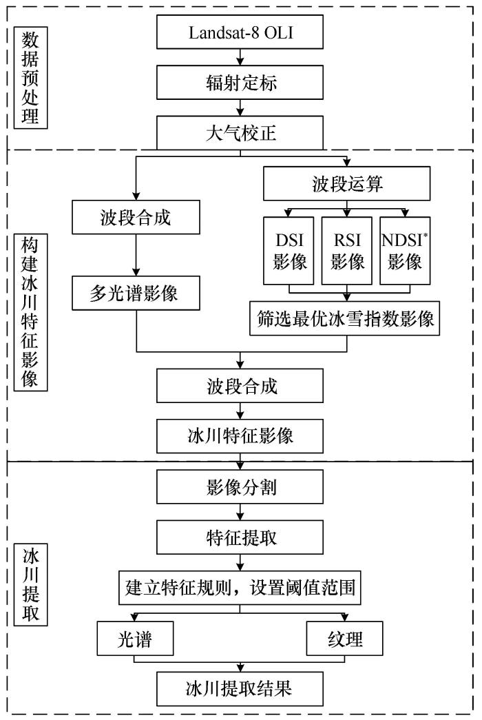
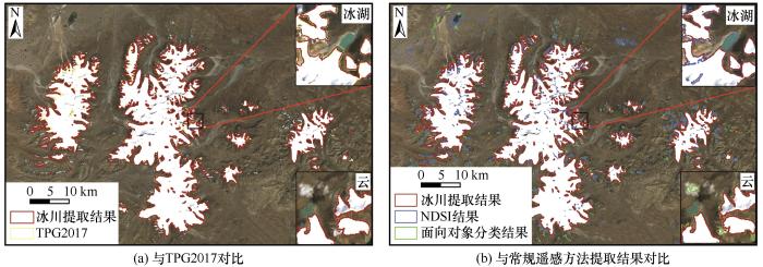
... 基于光学影像的常规遥感监测方法主要包括冰雪指数阈值法[6]以及特征分类法[7].冰雪指数阈值法基于冰雪在可见光波段的高反射率和近红外波段的低反射率,进行波段组合以及阈值设定获取冰川范围信息,具有简易、快速、相对准确的优势,在冰川监测中得到广泛应用[8].Huang等[9]使用“多时态最小NDSI复合法”实现了清洁冰川和非季节性积雪的提取,对于NDSI指数阈值法无法直接区分冰川与冰湖的问题,使用湖泊边界数据集对研究区影像进行湖泊掩膜处理,从而消除了冰湖对提取结果的影响;季漩等[10]提出增强型雪被指数(ENDSI)提取了岗加曲巴冰川山体阴影区的冰川范围;刘凯等[11]通过比值阈值法和目视解译法提取冰川边界,分析了1993—2015年喀喇昆仑山努布拉流域的冰川变化特征.以上冰雪指数阈值法的应用,从结果而言均实现了冰川范围提取,但未能从根本上解决冰雪指数阈值法无法直接区分冰川与冰湖的问题.特征分类法主要包括监督分类、非监督分类、面向对象分类、机器学习分类.Aniya等[12]通过非监督分类方法提取Patagonia冰原的冰川信息;彦立利等[13]基于面向对象的分类方法对玛纳斯河上游区域的冰川及常年积雪进行边界提取;王忠武等[14]提出一种上下文感知深度学习语义分割网络法消除了冰湖及山体阴影的影响完成了冰川范围提取.以上特征分类法的应用,同样实现了冰川范围提取,但仍普遍存在同谱异物现象.为解决以上常规遥感监测方法存在的问题,本文以Landsat-8数据为基础,根据冰雪的光敏波段以及OLI(operational land imager)传感器的波段特征构建可区分冰川、冰湖的改进冰雪指数,然后在此基础上将改进冰雪指数融入面向对象分类法中提出面向对象-改进冰雪指数法.以各拉丹冬冰川作为试验区,运用此方法识别冰川边界,并将此区域的青藏高原冰川数据产品及常规遥感监测方法提取结果作为参考数据,验证方法的有效性和稳健性. ...
Information extraction method of debris-covered glaciers in Bomi County
1
2017
... 基于光学影像的常规遥感监测方法主要包括冰雪指数阈值法[6]以及特征分类法[7].冰雪指数阈值法基于冰雪在可见光波段的高反射率和近红外波段的低反射率,进行波段组合以及阈值设定获取冰川范围信息,具有简易、快速、相对准确的优势,在冰川监测中得到广泛应用[8].Huang等[9]使用“多时态最小NDSI复合法”实现了清洁冰川和非季节性积雪的提取,对于NDSI指数阈值法无法直接区分冰川与冰湖的问题,使用湖泊边界数据集对研究区影像进行湖泊掩膜处理,从而消除了冰湖对提取结果的影响;季漩等[10]提出增强型雪被指数(ENDSI)提取了岗加曲巴冰川山体阴影区的冰川范围;刘凯等[11]通过比值阈值法和目视解译法提取冰川边界,分析了1993—2015年喀喇昆仑山努布拉流域的冰川变化特征.以上冰雪指数阈值法的应用,从结果而言均实现了冰川范围提取,但未能从根本上解决冰雪指数阈值法无法直接区分冰川与冰湖的问题.特征分类法主要包括监督分类、非监督分类、面向对象分类、机器学习分类.Aniya等[12]通过非监督分类方法提取Patagonia冰原的冰川信息;彦立利等[13]基于面向对象的分类方法对玛纳斯河上游区域的冰川及常年积雪进行边界提取;王忠武等[14]提出一种上下文感知深度学习语义分割网络法消除了冰湖及山体阴影的影响完成了冰川范围提取.以上特征分类法的应用,同样实现了冰川范围提取,但仍普遍存在同谱异物现象.为解决以上常规遥感监测方法存在的问题,本文以Landsat-8数据为基础,根据冰雪的光敏波段以及OLI(operational land imager)传感器的波段特征构建可区分冰川、冰湖的改进冰雪指数,然后在此基础上将改进冰雪指数融入面向对象分类法中提出面向对象-改进冰雪指数法.以各拉丹冬冰川作为试验区,运用此方法识别冰川边界,并将此区域的青藏高原冰川数据产品及常规遥感监测方法提取结果作为参考数据,验证方法的有效性和稳健性. ...
表碛覆盖冰川信息提取方法: 以波密县为例
1
2017
... 基于光学影像的常规遥感监测方法主要包括冰雪指数阈值法[6]以及特征分类法[7].冰雪指数阈值法基于冰雪在可见光波段的高反射率和近红外波段的低反射率,进行波段组合以及阈值设定获取冰川范围信息,具有简易、快速、相对准确的优势,在冰川监测中得到广泛应用[8].Huang等[9]使用“多时态最小NDSI复合法”实现了清洁冰川和非季节性积雪的提取,对于NDSI指数阈值法无法直接区分冰川与冰湖的问题,使用湖泊边界数据集对研究区影像进行湖泊掩膜处理,从而消除了冰湖对提取结果的影响;季漩等[10]提出增强型雪被指数(ENDSI)提取了岗加曲巴冰川山体阴影区的冰川范围;刘凯等[11]通过比值阈值法和目视解译法提取冰川边界,分析了1993—2015年喀喇昆仑山努布拉流域的冰川变化特征.以上冰雪指数阈值法的应用,从结果而言均实现了冰川范围提取,但未能从根本上解决冰雪指数阈值法无法直接区分冰川与冰湖的问题.特征分类法主要包括监督分类、非监督分类、面向对象分类、机器学习分类.Aniya等[12]通过非监督分类方法提取Patagonia冰原的冰川信息;彦立利等[13]基于面向对象的分类方法对玛纳斯河上游区域的冰川及常年积雪进行边界提取;王忠武等[14]提出一种上下文感知深度学习语义分割网络法消除了冰湖及山体阴影的影响完成了冰川范围提取.以上特征分类法的应用,同样实现了冰川范围提取,但仍普遍存在同谱异物现象.为解决以上常规遥感监测方法存在的问题,本文以Landsat-8数据为基础,根据冰雪的光敏波段以及OLI(operational land imager)传感器的波段特征构建可区分冰川、冰湖的改进冰雪指数,然后在此基础上将改进冰雪指数融入面向对象分类法中提出面向对象-改进冰雪指数法.以各拉丹冬冰川作为试验区,运用此方法识别冰川边界,并将此区域的青藏高原冰川数据产品及常规遥感监测方法提取结果作为参考数据,验证方法的有效性和稳健性. ...
Remote sensing monitoring of the change of glacier and snow cover and its influencing factors in Mount Bogda
1
2019
... 基于光学影像的常规遥感监测方法主要包括冰雪指数阈值法[6]以及特征分类法[7].冰雪指数阈值法基于冰雪在可见光波段的高反射率和近红外波段的低反射率,进行波段组合以及阈值设定获取冰川范围信息,具有简易、快速、相对准确的优势,在冰川监测中得到广泛应用[8].Huang等[9]使用“多时态最小NDSI复合法”实现了清洁冰川和非季节性积雪的提取,对于NDSI指数阈值法无法直接区分冰川与冰湖的问题,使用湖泊边界数据集对研究区影像进行湖泊掩膜处理,从而消除了冰湖对提取结果的影响;季漩等[10]提出增强型雪被指数(ENDSI)提取了岗加曲巴冰川山体阴影区的冰川范围;刘凯等[11]通过比值阈值法和目视解译法提取冰川边界,分析了1993—2015年喀喇昆仑山努布拉流域的冰川变化特征.以上冰雪指数阈值法的应用,从结果而言均实现了冰川范围提取,但未能从根本上解决冰雪指数阈值法无法直接区分冰川与冰湖的问题.特征分类法主要包括监督分类、非监督分类、面向对象分类、机器学习分类.Aniya等[12]通过非监督分类方法提取Patagonia冰原的冰川信息;彦立利等[13]基于面向对象的分类方法对玛纳斯河上游区域的冰川及常年积雪进行边界提取;王忠武等[14]提出一种上下文感知深度学习语义分割网络法消除了冰湖及山体阴影的影响完成了冰川范围提取.以上特征分类法的应用,同样实现了冰川范围提取,但仍普遍存在同谱异物现象.为解决以上常规遥感监测方法存在的问题,本文以Landsat-8数据为基础,根据冰雪的光敏波段以及OLI(operational land imager)传感器的波段特征构建可区分冰川、冰湖的改进冰雪指数,然后在此基础上将改进冰雪指数融入面向对象分类法中提出面向对象-改进冰雪指数法.以各拉丹冬冰川作为试验区,运用此方法识别冰川边界,并将此区域的青藏高原冰川数据产品及常规遥感监测方法提取结果作为参考数据,验证方法的有效性和稳健性. ...
博格达峰地区冰川和积雪变化遥感监测及影响因素分析
1
2019
... 基于光学影像的常规遥感监测方法主要包括冰雪指数阈值法[6]以及特征分类法[7].冰雪指数阈值法基于冰雪在可见光波段的高反射率和近红外波段的低反射率,进行波段组合以及阈值设定获取冰川范围信息,具有简易、快速、相对准确的优势,在冰川监测中得到广泛应用[8].Huang等[9]使用“多时态最小NDSI复合法”实现了清洁冰川和非季节性积雪的提取,对于NDSI指数阈值法无法直接区分冰川与冰湖的问题,使用湖泊边界数据集对研究区影像进行湖泊掩膜处理,从而消除了冰湖对提取结果的影响;季漩等[10]提出增强型雪被指数(ENDSI)提取了岗加曲巴冰川山体阴影区的冰川范围;刘凯等[11]通过比值阈值法和目视解译法提取冰川边界,分析了1993—2015年喀喇昆仑山努布拉流域的冰川变化特征.以上冰雪指数阈值法的应用,从结果而言均实现了冰川范围提取,但未能从根本上解决冰雪指数阈值法无法直接区分冰川与冰湖的问题.特征分类法主要包括监督分类、非监督分类、面向对象分类、机器学习分类.Aniya等[12]通过非监督分类方法提取Patagonia冰原的冰川信息;彦立利等[13]基于面向对象的分类方法对玛纳斯河上游区域的冰川及常年积雪进行边界提取;王忠武等[14]提出一种上下文感知深度学习语义分割网络法消除了冰湖及山体阴影的影响完成了冰川范围提取.以上特征分类法的应用,同样实现了冰川范围提取,但仍普遍存在同谱异物现象.为解决以上常规遥感监测方法存在的问题,本文以Landsat-8数据为基础,根据冰雪的光敏波段以及OLI(operational land imager)传感器的波段特征构建可区分冰川、冰湖的改进冰雪指数,然后在此基础上将改进冰雪指数融入面向对象分类法中提出面向对象-改进冰雪指数法.以各拉丹冬冰川作为试验区,运用此方法识别冰川边界,并将此区域的青藏高原冰川数据产品及常规遥感监测方法提取结果作为参考数据,验证方法的有效性和稳健性. ...
An automatic method for clean glacier and nonseasonal snow area change estimation in High Mountain Asia from 1990 to 2018
1
2021
... 基于光学影像的常规遥感监测方法主要包括冰雪指数阈值法[6]以及特征分类法[7].冰雪指数阈值法基于冰雪在可见光波段的高反射率和近红外波段的低反射率,进行波段组合以及阈值设定获取冰川范围信息,具有简易、快速、相对准确的优势,在冰川监测中得到广泛应用[8].Huang等[9]使用“多时态最小NDSI复合法”实现了清洁冰川和非季节性积雪的提取,对于NDSI指数阈值法无法直接区分冰川与冰湖的问题,使用湖泊边界数据集对研究区影像进行湖泊掩膜处理,从而消除了冰湖对提取结果的影响;季漩等[10]提出增强型雪被指数(ENDSI)提取了岗加曲巴冰川山体阴影区的冰川范围;刘凯等[11]通过比值阈值法和目视解译法提取冰川边界,分析了1993—2015年喀喇昆仑山努布拉流域的冰川变化特征.以上冰雪指数阈值法的应用,从结果而言均实现了冰川范围提取,但未能从根本上解决冰雪指数阈值法无法直接区分冰川与冰湖的问题.特征分类法主要包括监督分类、非监督分类、面向对象分类、机器学习分类.Aniya等[12]通过非监督分类方法提取Patagonia冰原的冰川信息;彦立利等[13]基于面向对象的分类方法对玛纳斯河上游区域的冰川及常年积雪进行边界提取;王忠武等[14]提出一种上下文感知深度学习语义分割网络法消除了冰湖及山体阴影的影响完成了冰川范围提取.以上特征分类法的应用,同样实现了冰川范围提取,但仍普遍存在同谱异物现象.为解决以上常规遥感监测方法存在的问题,本文以Landsat-8数据为基础,根据冰雪的光敏波段以及OLI(operational land imager)传感器的波段特征构建可区分冰川、冰湖的改进冰雪指数,然后在此基础上将改进冰雪指数融入面向对象分类法中提出面向对象-改进冰雪指数法.以各拉丹冬冰川作为试验区,运用此方法识别冰川边界,并将此区域的青藏高原冰川数据产品及常规遥感监测方法提取结果作为参考数据,验证方法的有效性和稳健性. ...
Study on the identification method of glacier in mountain shadows based on Landsat 8 OLI image
1
2018
... 基于光学影像的常规遥感监测方法主要包括冰雪指数阈值法[6]以及特征分类法[7].冰雪指数阈值法基于冰雪在可见光波段的高反射率和近红外波段的低反射率,进行波段组合以及阈值设定获取冰川范围信息,具有简易、快速、相对准确的优势,在冰川监测中得到广泛应用[8].Huang等[9]使用“多时态最小NDSI复合法”实现了清洁冰川和非季节性积雪的提取,对于NDSI指数阈值法无法直接区分冰川与冰湖的问题,使用湖泊边界数据集对研究区影像进行湖泊掩膜处理,从而消除了冰湖对提取结果的影响;季漩等[10]提出增强型雪被指数(ENDSI)提取了岗加曲巴冰川山体阴影区的冰川范围;刘凯等[11]通过比值阈值法和目视解译法提取冰川边界,分析了1993—2015年喀喇昆仑山努布拉流域的冰川变化特征.以上冰雪指数阈值法的应用,从结果而言均实现了冰川范围提取,但未能从根本上解决冰雪指数阈值法无法直接区分冰川与冰湖的问题.特征分类法主要包括监督分类、非监督分类、面向对象分类、机器学习分类.Aniya等[12]通过非监督分类方法提取Patagonia冰原的冰川信息;彦立利等[13]基于面向对象的分类方法对玛纳斯河上游区域的冰川及常年积雪进行边界提取;王忠武等[14]提出一种上下文感知深度学习语义分割网络法消除了冰湖及山体阴影的影响完成了冰川范围提取.以上特征分类法的应用,同样实现了冰川范围提取,但仍普遍存在同谱异物现象.为解决以上常规遥感监测方法存在的问题,本文以Landsat-8数据为基础,根据冰雪的光敏波段以及OLI(operational land imager)传感器的波段特征构建可区分冰川、冰湖的改进冰雪指数,然后在此基础上将改进冰雪指数融入面向对象分类法中提出面向对象-改进冰雪指数法.以各拉丹冬冰川作为试验区,运用此方法识别冰川边界,并将此区域的青藏高原冰川数据产品及常规遥感监测方法提取结果作为参考数据,验证方法的有效性和稳健性. ...
Landsat 8 OLI影像的高原山地阴影区冰川识别方法
1
2018
... 基于光学影像的常规遥感监测方法主要包括冰雪指数阈值法[6]以及特征分类法[7].冰雪指数阈值法基于冰雪在可见光波段的高反射率和近红外波段的低反射率,进行波段组合以及阈值设定获取冰川范围信息,具有简易、快速、相对准确的优势,在冰川监测中得到广泛应用[8].Huang等[9]使用“多时态最小NDSI复合法”实现了清洁冰川和非季节性积雪的提取,对于NDSI指数阈值法无法直接区分冰川与冰湖的问题,使用湖泊边界数据集对研究区影像进行湖泊掩膜处理,从而消除了冰湖对提取结果的影响;季漩等[10]提出增强型雪被指数(ENDSI)提取了岗加曲巴冰川山体阴影区的冰川范围;刘凯等[11]通过比值阈值法和目视解译法提取冰川边界,分析了1993—2015年喀喇昆仑山努布拉流域的冰川变化特征.以上冰雪指数阈值法的应用,从结果而言均实现了冰川范围提取,但未能从根本上解决冰雪指数阈值法无法直接区分冰川与冰湖的问题.特征分类法主要包括监督分类、非监督分类、面向对象分类、机器学习分类.Aniya等[12]通过非监督分类方法提取Patagonia冰原的冰川信息;彦立利等[13]基于面向对象的分类方法对玛纳斯河上游区域的冰川及常年积雪进行边界提取;王忠武等[14]提出一种上下文感知深度学习语义分割网络法消除了冰湖及山体阴影的影响完成了冰川范围提取.以上特征分类法的应用,同样实现了冰川范围提取,但仍普遍存在同谱异物现象.为解决以上常规遥感监测方法存在的问题,本文以Landsat-8数据为基础,根据冰雪的光敏波段以及OLI(operational land imager)传感器的波段特征构建可区分冰川、冰湖的改进冰雪指数,然后在此基础上将改进冰雪指数融入面向对象分类法中提出面向对象-改进冰雪指数法.以各拉丹冬冰川作为试验区,运用此方法识别冰川边界,并将此区域的青藏高原冰川数据产品及常规遥感监测方法提取结果作为参考数据,验证方法的有效性和稳健性. ...
Variation of glaciers in the Nubra basin, Karakoram Mountains, revealed by remote sensing images during 1993—2015
1
2017
... 基于光学影像的常规遥感监测方法主要包括冰雪指数阈值法[6]以及特征分类法[7].冰雪指数阈值法基于冰雪在可见光波段的高反射率和近红外波段的低反射率,进行波段组合以及阈值设定获取冰川范围信息,具有简易、快速、相对准确的优势,在冰川监测中得到广泛应用[8].Huang等[9]使用“多时态最小NDSI复合法”实现了清洁冰川和非季节性积雪的提取,对于NDSI指数阈值法无法直接区分冰川与冰湖的问题,使用湖泊边界数据集对研究区影像进行湖泊掩膜处理,从而消除了冰湖对提取结果的影响;季漩等[10]提出增强型雪被指数(ENDSI)提取了岗加曲巴冰川山体阴影区的冰川范围;刘凯等[11]通过比值阈值法和目视解译法提取冰川边界,分析了1993—2015年喀喇昆仑山努布拉流域的冰川变化特征.以上冰雪指数阈值法的应用,从结果而言均实现了冰川范围提取,但未能从根本上解决冰雪指数阈值法无法直接区分冰川与冰湖的问题.特征分类法主要包括监督分类、非监督分类、面向对象分类、机器学习分类.Aniya等[12]通过非监督分类方法提取Patagonia冰原的冰川信息;彦立利等[13]基于面向对象的分类方法对玛纳斯河上游区域的冰川及常年积雪进行边界提取;王忠武等[14]提出一种上下文感知深度学习语义分割网络法消除了冰湖及山体阴影的影响完成了冰川范围提取.以上特征分类法的应用,同样实现了冰川范围提取,但仍普遍存在同谱异物现象.为解决以上常规遥感监测方法存在的问题,本文以Landsat-8数据为基础,根据冰雪的光敏波段以及OLI(operational land imager)传感器的波段特征构建可区分冰川、冰湖的改进冰雪指数,然后在此基础上将改进冰雪指数融入面向对象分类法中提出面向对象-改进冰雪指数法.以各拉丹冬冰川作为试验区,运用此方法识别冰川边界,并将此区域的青藏高原冰川数据产品及常规遥感监测方法提取结果作为参考数据,验证方法的有效性和稳健性. ...
1993—2015年喀喇昆仑山努布拉流域冰川变化遥感监测
1
2017
... 基于光学影像的常规遥感监测方法主要包括冰雪指数阈值法[6]以及特征分类法[7].冰雪指数阈值法基于冰雪在可见光波段的高反射率和近红外波段的低反射率,进行波段组合以及阈值设定获取冰川范围信息,具有简易、快速、相对准确的优势,在冰川监测中得到广泛应用[8].Huang等[9]使用“多时态最小NDSI复合法”实现了清洁冰川和非季节性积雪的提取,对于NDSI指数阈值法无法直接区分冰川与冰湖的问题,使用湖泊边界数据集对研究区影像进行湖泊掩膜处理,从而消除了冰湖对提取结果的影响;季漩等[10]提出增强型雪被指数(ENDSI)提取了岗加曲巴冰川山体阴影区的冰川范围;刘凯等[11]通过比值阈值法和目视解译法提取冰川边界,分析了1993—2015年喀喇昆仑山努布拉流域的冰川变化特征.以上冰雪指数阈值法的应用,从结果而言均实现了冰川范围提取,但未能从根本上解决冰雪指数阈值法无法直接区分冰川与冰湖的问题.特征分类法主要包括监督分类、非监督分类、面向对象分类、机器学习分类.Aniya等[12]通过非监督分类方法提取Patagonia冰原的冰川信息;彦立利等[13]基于面向对象的分类方法对玛纳斯河上游区域的冰川及常年积雪进行边界提取;王忠武等[14]提出一种上下文感知深度学习语义分割网络法消除了冰湖及山体阴影的影响完成了冰川范围提取.以上特征分类法的应用,同样实现了冰川范围提取,但仍普遍存在同谱异物现象.为解决以上常规遥感监测方法存在的问题,本文以Landsat-8数据为基础,根据冰雪的光敏波段以及OLI(operational land imager)传感器的波段特征构建可区分冰川、冰湖的改进冰雪指数,然后在此基础上将改进冰雪指数融入面向对象分类法中提出面向对象-改进冰雪指数法.以各拉丹冬冰川作为试验区,运用此方法识别冰川边界,并将此区域的青藏高原冰川数据产品及常规遥感监测方法提取结果作为参考数据,验证方法的有效性和稳健性. ...
The use of satellite and airborne imagery to inventory outlet glaciers of the Southern Patagonia Icefield, South America
1
1996
... 基于光学影像的常规遥感监测方法主要包括冰雪指数阈值法[6]以及特征分类法[7].冰雪指数阈值法基于冰雪在可见光波段的高反射率和近红外波段的低反射率,进行波段组合以及阈值设定获取冰川范围信息,具有简易、快速、相对准确的优势,在冰川监测中得到广泛应用[8].Huang等[9]使用“多时态最小NDSI复合法”实现了清洁冰川和非季节性积雪的提取,对于NDSI指数阈值法无法直接区分冰川与冰湖的问题,使用湖泊边界数据集对研究区影像进行湖泊掩膜处理,从而消除了冰湖对提取结果的影响;季漩等[10]提出增强型雪被指数(ENDSI)提取了岗加曲巴冰川山体阴影区的冰川范围;刘凯等[11]通过比值阈值法和目视解译法提取冰川边界,分析了1993—2015年喀喇昆仑山努布拉流域的冰川变化特征.以上冰雪指数阈值法的应用,从结果而言均实现了冰川范围提取,但未能从根本上解决冰雪指数阈值法无法直接区分冰川与冰湖的问题.特征分类法主要包括监督分类、非监督分类、面向对象分类、机器学习分类.Aniya等[12]通过非监督分类方法提取Patagonia冰原的冰川信息;彦立利等[13]基于面向对象的分类方法对玛纳斯河上游区域的冰川及常年积雪进行边界提取;王忠武等[14]提出一种上下文感知深度学习语义分割网络法消除了冰湖及山体阴影的影响完成了冰川范围提取.以上特征分类法的应用,同样实现了冰川范围提取,但仍普遍存在同谱异物现象.为解决以上常规遥感监测方法存在的问题,本文以Landsat-8数据为基础,根据冰雪的光敏波段以及OLI(operational land imager)传感器的波段特征构建可区分冰川、冰湖的改进冰雪指数,然后在此基础上将改进冰雪指数融入面向对象分类法中提出面向对象-改进冰雪指数法.以各拉丹冬冰川作为试验区,运用此方法识别冰川边界,并将此区域的青藏高原冰川数据产品及常规遥感监测方法提取结果作为参考数据,验证方法的有效性和稳健性. ...
Glacier boundary recognition based on GF-1 satellite remote sensing
1
2020
... 基于光学影像的常规遥感监测方法主要包括冰雪指数阈值法[6]以及特征分类法[7].冰雪指数阈值法基于冰雪在可见光波段的高反射率和近红外波段的低反射率,进行波段组合以及阈值设定获取冰川范围信息,具有简易、快速、相对准确的优势,在冰川监测中得到广泛应用[8].Huang等[9]使用“多时态最小NDSI复合法”实现了清洁冰川和非季节性积雪的提取,对于NDSI指数阈值法无法直接区分冰川与冰湖的问题,使用湖泊边界数据集对研究区影像进行湖泊掩膜处理,从而消除了冰湖对提取结果的影响;季漩等[10]提出增强型雪被指数(ENDSI)提取了岗加曲巴冰川山体阴影区的冰川范围;刘凯等[11]通过比值阈值法和目视解译法提取冰川边界,分析了1993—2015年喀喇昆仑山努布拉流域的冰川变化特征.以上冰雪指数阈值法的应用,从结果而言均实现了冰川范围提取,但未能从根本上解决冰雪指数阈值法无法直接区分冰川与冰湖的问题.特征分类法主要包括监督分类、非监督分类、面向对象分类、机器学习分类.Aniya等[12]通过非监督分类方法提取Patagonia冰原的冰川信息;彦立利等[13]基于面向对象的分类方法对玛纳斯河上游区域的冰川及常年积雪进行边界提取;王忠武等[14]提出一种上下文感知深度学习语义分割网络法消除了冰湖及山体阴影的影响完成了冰川范围提取.以上特征分类法的应用,同样实现了冰川范围提取,但仍普遍存在同谱异物现象.为解决以上常规遥感监测方法存在的问题,本文以Landsat-8数据为基础,根据冰雪的光敏波段以及OLI(operational land imager)传感器的波段特征构建可区分冰川、冰湖的改进冰雪指数,然后在此基础上将改进冰雪指数融入面向对象分类法中提出面向对象-改进冰雪指数法.以各拉丹冬冰川作为试验区,运用此方法识别冰川边界,并将此区域的青藏高原冰川数据产品及常规遥感监测方法提取结果作为参考数据,验证方法的有效性和稳健性. ...
基于GF-1卫星遥感的冰川边界识别
1
2020
... 基于光学影像的常规遥感监测方法主要包括冰雪指数阈值法[6]以及特征分类法[7].冰雪指数阈值法基于冰雪在可见光波段的高反射率和近红外波段的低反射率,进行波段组合以及阈值设定获取冰川范围信息,具有简易、快速、相对准确的优势,在冰川监测中得到广泛应用[8].Huang等[9]使用“多时态最小NDSI复合法”实现了清洁冰川和非季节性积雪的提取,对于NDSI指数阈值法无法直接区分冰川与冰湖的问题,使用湖泊边界数据集对研究区影像进行湖泊掩膜处理,从而消除了冰湖对提取结果的影响;季漩等[10]提出增强型雪被指数(ENDSI)提取了岗加曲巴冰川山体阴影区的冰川范围;刘凯等[11]通过比值阈值法和目视解译法提取冰川边界,分析了1993—2015年喀喇昆仑山努布拉流域的冰川变化特征.以上冰雪指数阈值法的应用,从结果而言均实现了冰川范围提取,但未能从根本上解决冰雪指数阈值法无法直接区分冰川与冰湖的问题.特征分类法主要包括监督分类、非监督分类、面向对象分类、机器学习分类.Aniya等[12]通过非监督分类方法提取Patagonia冰原的冰川信息;彦立利等[13]基于面向对象的分类方法对玛纳斯河上游区域的冰川及常年积雪进行边界提取;王忠武等[14]提出一种上下文感知深度学习语义分割网络法消除了冰湖及山体阴影的影响完成了冰川范围提取.以上特征分类法的应用,同样实现了冰川范围提取,但仍普遍存在同谱异物现象.为解决以上常规遥感监测方法存在的问题,本文以Landsat-8数据为基础,根据冰雪的光敏波段以及OLI(operational land imager)传感器的波段特征构建可区分冰川、冰湖的改进冰雪指数,然后在此基础上将改进冰雪指数融入面向对象分类法中提出面向对象-改进冰雪指数法.以各拉丹冬冰川作为试验区,运用此方法识别冰川边界,并将此区域的青藏高原冰川数据产品及常规遥感监测方法提取结果作为参考数据,验证方法的有效性和稳健性. ...
Context-aware semantic segmentation network method for glacier extraction from Landsat images
1
2020
... 基于光学影像的常规遥感监测方法主要包括冰雪指数阈值法[6]以及特征分类法[7].冰雪指数阈值法基于冰雪在可见光波段的高反射率和近红外波段的低反射率,进行波段组合以及阈值设定获取冰川范围信息,具有简易、快速、相对准确的优势,在冰川监测中得到广泛应用[8].Huang等[9]使用“多时态最小NDSI复合法”实现了清洁冰川和非季节性积雪的提取,对于NDSI指数阈值法无法直接区分冰川与冰湖的问题,使用湖泊边界数据集对研究区影像进行湖泊掩膜处理,从而消除了冰湖对提取结果的影响;季漩等[10]提出增强型雪被指数(ENDSI)提取了岗加曲巴冰川山体阴影区的冰川范围;刘凯等[11]通过比值阈值法和目视解译法提取冰川边界,分析了1993—2015年喀喇昆仑山努布拉流域的冰川变化特征.以上冰雪指数阈值法的应用,从结果而言均实现了冰川范围提取,但未能从根本上解决冰雪指数阈值法无法直接区分冰川与冰湖的问题.特征分类法主要包括监督分类、非监督分类、面向对象分类、机器学习分类.Aniya等[12]通过非监督分类方法提取Patagonia冰原的冰川信息;彦立利等[13]基于面向对象的分类方法对玛纳斯河上游区域的冰川及常年积雪进行边界提取;王忠武等[14]提出一种上下文感知深度学习语义分割网络法消除了冰湖及山体阴影的影响完成了冰川范围提取.以上特征分类法的应用,同样实现了冰川范围提取,但仍普遍存在同谱异物现象.为解决以上常规遥感监测方法存在的问题,本文以Landsat-8数据为基础,根据冰雪的光敏波段以及OLI(operational land imager)传感器的波段特征构建可区分冰川、冰湖的改进冰雪指数,然后在此基础上将改进冰雪指数融入面向对象分类法中提出面向对象-改进冰雪指数法.以各拉丹冬冰川作为试验区,运用此方法识别冰川边界,并将此区域的青藏高原冰川数据产品及常规遥感监测方法提取结果作为参考数据,验证方法的有效性和稳健性. ...
Landsat影像冰川提取的上下文感知语义分割网络法
1
2020
... 基于光学影像的常规遥感监测方法主要包括冰雪指数阈值法[6]以及特征分类法[7].冰雪指数阈值法基于冰雪在可见光波段的高反射率和近红外波段的低反射率,进行波段组合以及阈值设定获取冰川范围信息,具有简易、快速、相对准确的优势,在冰川监测中得到广泛应用[8].Huang等[9]使用“多时态最小NDSI复合法”实现了清洁冰川和非季节性积雪的提取,对于NDSI指数阈值法无法直接区分冰川与冰湖的问题,使用湖泊边界数据集对研究区影像进行湖泊掩膜处理,从而消除了冰湖对提取结果的影响;季漩等[10]提出增强型雪被指数(ENDSI)提取了岗加曲巴冰川山体阴影区的冰川范围;刘凯等[11]通过比值阈值法和目视解译法提取冰川边界,分析了1993—2015年喀喇昆仑山努布拉流域的冰川变化特征.以上冰雪指数阈值法的应用,从结果而言均实现了冰川范围提取,但未能从根本上解决冰雪指数阈值法无法直接区分冰川与冰湖的问题.特征分类法主要包括监督分类、非监督分类、面向对象分类、机器学习分类.Aniya等[12]通过非监督分类方法提取Patagonia冰原的冰川信息;彦立利等[13]基于面向对象的分类方法对玛纳斯河上游区域的冰川及常年积雪进行边界提取;王忠武等[14]提出一种上下文感知深度学习语义分割网络法消除了冰湖及山体阴影的影响完成了冰川范围提取.以上特征分类法的应用,同样实现了冰川范围提取,但仍普遍存在同谱异物现象.为解决以上常规遥感监测方法存在的问题,本文以Landsat-8数据为基础,根据冰雪的光敏波段以及OLI(operational land imager)传感器的波段特征构建可区分冰川、冰湖的改进冰雪指数,然后在此基础上将改进冰雪指数融入面向对象分类法中提出面向对象-改进冰雪指数法.以各拉丹冬冰川作为试验区,运用此方法识别冰川边界,并将此区域的青藏高原冰川数据产品及常规遥感监测方法提取结果作为参考数据,验证方法的有效性和稳健性. ...
Changes of Geladandong Glacier at the source of the Yangtze River in recent 20 years and its response to climate change
1
2014
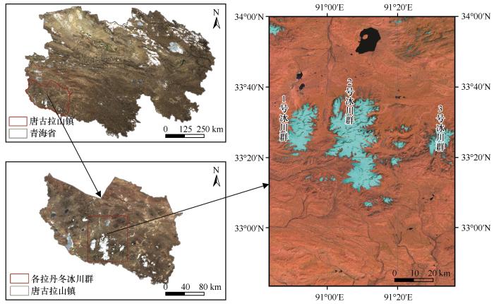
... 各拉丹冬冰川位于青海省格尔木市唐古拉山镇,属于内陆高寒地区,地理位置为33°00′~33°40′ N、90°45′~91°20′ E[15],东西宽约30 km,南北长约50 km.该地区常年气温在0 ℃以下,年降水量仅200 mm,且90%集中在5—9月[16].唐古拉山境内有现代冰川1 530条,总面积约2 313 km[17],各拉丹冬冰川群是其中最大的冰川群.各拉丹冬冰川群中有三个较大冰川群[18](图1),其冰川融水是长江源头重要的补给来源,本研究以这三个冰川群为研究对象. ...
近20年长江源头各拉丹冬冰川变化及其对气候变化的响应
1
2014
... 各拉丹冬冰川位于青海省格尔木市唐古拉山镇,属于内陆高寒地区,地理位置为33°00′~33°40′ N、90°45′~91°20′ E[15],东西宽约30 km,南北长约50 km.该地区常年气温在0 ℃以下,年降水量仅200 mm,且90%集中在5—9月[16].唐古拉山境内有现代冰川1 530条,总面积约2 313 km[17],各拉丹冬冰川群是其中最大的冰川群.各拉丹冬冰川群中有三个较大冰川群[18](图1),其冰川融水是长江源头重要的补给来源,本研究以这三个冰川群为研究对象. ...
Remote sensing monitoring on glacier change in Geladandong area from 1992 to 2015, a source area of Yangtze River
1
2018
... 各拉丹冬冰川位于青海省格尔木市唐古拉山镇,属于内陆高寒地区,地理位置为33°00′~33°40′ N、90°45′~91°20′ E[15],东西宽约30 km,南北长约50 km.该地区常年气温在0 ℃以下,年降水量仅200 mm,且90%集中在5—9月[16].唐古拉山境内有现代冰川1 530条,总面积约2 313 km[17],各拉丹冬冰川群是其中最大的冰川群.各拉丹冬冰川群中有三个较大冰川群[18](图1),其冰川融水是长江源头重要的补给来源,本研究以这三个冰川群为研究对象. ...
长江源各拉丹冬地区冰川变化遥感监测分析
1
2018
... 各拉丹冬冰川位于青海省格尔木市唐古拉山镇,属于内陆高寒地区,地理位置为33°00′~33°40′ N、90°45′~91°20′ E[15],东西宽约30 km,南北长约50 km.该地区常年气温在0 ℃以下,年降水量仅200 mm,且90%集中在5—9月[16].唐古拉山境内有现代冰川1 530条,总面积约2 313 km[17],各拉丹冬冰川群是其中最大的冰川群.各拉丹冬冰川群中有三个较大冰川群[18](图1),其冰川融水是长江源头重要的补给来源,本研究以这三个冰川群为研究对象. ...
The Quaternary glaciations and glacier properties in the Tanggula Range
1
2003
... 各拉丹冬冰川位于青海省格尔木市唐古拉山镇,属于内陆高寒地区,地理位置为33°00′~33°40′ N、90°45′~91°20′ E[15],东西宽约30 km,南北长约50 km.该地区常年气温在0 ℃以下,年降水量仅200 mm,且90%集中在5—9月[16].唐古拉山境内有现代冰川1 530条,总面积约2 313 km[17],各拉丹冬冰川群是其中最大的冰川群.各拉丹冬冰川群中有三个较大冰川群[18](图1),其冰川融水是长江源头重要的补给来源,本研究以这三个冰川群为研究对象. ...
唐古拉山地区第四纪冰川作用与冰川特征
1
2003
... 各拉丹冬冰川位于青海省格尔木市唐古拉山镇,属于内陆高寒地区,地理位置为33°00′~33°40′ N、90°45′~91°20′ E[15],东西宽约30 km,南北长约50 km.该地区常年气温在0 ℃以下,年降水量仅200 mm,且90%集中在5—9月[16].唐古拉山境内有现代冰川1 530条,总面积约2 313 km[17],各拉丹冬冰川群是其中最大的冰川群.各拉丹冬冰川群中有三个较大冰川群[18](图1),其冰川融水是长江源头重要的补给来源,本研究以这三个冰川群为研究对象. ...
Geladandong information extraction based on the texture features of SAR image
1
2015
... 各拉丹冬冰川位于青海省格尔木市唐古拉山镇,属于内陆高寒地区,地理位置为33°00′~33°40′ N、90°45′~91°20′ E[15],东西宽约30 km,南北长约50 km.该地区常年气温在0 ℃以下,年降水量仅200 mm,且90%集中在5—9月[16].唐古拉山境内有现代冰川1 530条,总面积约2 313 km[17],各拉丹冬冰川群是其中最大的冰川群.各拉丹冬冰川群中有三个较大冰川群[18](图1),其冰川融水是长江源头重要的补给来源,本研究以这三个冰川群为研究对象. ...
基于纹理特征的SAR影像各拉丹冬冰川信息提取
1
2015
... 各拉丹冬冰川位于青海省格尔木市唐古拉山镇,属于内陆高寒地区,地理位置为33°00′~33°40′ N、90°45′~91°20′ E[15],东西宽约30 km,南北长约50 km.该地区常年气温在0 ℃以下,年降水量仅200 mm,且90%集中在5—9月[16].唐古拉山境内有现代冰川1 530条,总面积约2 313 km[17],各拉丹冬冰川群是其中最大的冰川群.各拉丹冬冰川群中有三个较大冰川群[18](图1),其冰川融水是长江源头重要的补给来源,本研究以这三个冰川群为研究对象. ...
Malan Ice Cap change and climate response based on object-oriented classification
1
2017
... 基于规则的面向对象分类法是通过影像分割将影像分为若干同质性像元组成的影像对象,然后将影像对象作为分析单元,综合分析其光谱特征、纹理特征形成对象特征知识库,最后在此基础上进行目标信息的提取.此方法在高海拔区域的冰川识别方面较传统分类方法精度更高[19].采用基于规则的面向对象分类法对冰雪指数阈值法进行优化和综合即面向对象-改进冰雪指数法,进一步明确冰湖和冰川的边界,精确提取冰川范围. ...
基于面向对象分类的马兰冰帽变化与气候响应
1
2017
... 基于规则的面向对象分类法是通过影像分割将影像分为若干同质性像元组成的影像对象,然后将影像对象作为分析单元,综合分析其光谱特征、纹理特征形成对象特征知识库,最后在此基础上进行目标信息的提取.此方法在高海拔区域的冰川识别方面较传统分类方法精度更高[19].采用基于规则的面向对象分类法对冰雪指数阈值法进行优化和综合即面向对象-改进冰雪指数法,进一步明确冰湖和冰川的边界,精确提取冰川范围. ...
Object-oriented research on GF-1 remote sensing classification of desertified land
1
2015
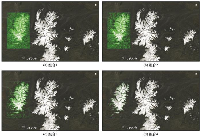
... 创建影像对象的过程包括影像分割和合并.冰川在遥感影像中与其背景环境差异显著,因而采用边缘检测分割算法,基于影像中相邻区域像元的光谱、纹理特征,调整分割参数实现不同尺度影像对象边界的分割,从而产生由细到粗的多尺度分割结果.影像分割时,一个特征对象可能会被分成很多个部分,合并算法可解决这个问题,冰川像元具有连续性、纹理性较强的特征,所以采用Full Lambda Schedule算法[20]进行合并.分割合并参数阈值的设定,对冰川对象内部的差异性以及冰川对象与其他地物类别之间的异质性均存在较大影响[21],如表3所示进行多次试验,结果如图5所示.当冰川对象边界清晰,影像对象不破碎且不包括其他类别地物时,确定最优组合分割合并阈值组合(70,98). ...
面向对象的沙化土地GF-1遥感分类技术研究
1
2015
... 创建影像对象的过程包括影像分割和合并.冰川在遥感影像中与其背景环境差异显著,因而采用边缘检测分割算法,基于影像中相邻区域像元的光谱、纹理特征,调整分割参数实现不同尺度影像对象边界的分割,从而产生由细到粗的多尺度分割结果.影像分割时,一个特征对象可能会被分成很多个部分,合并算法可解决这个问题,冰川像元具有连续性、纹理性较强的特征,所以采用Full Lambda Schedule算法[20]进行合并.分割合并参数阈值的设定,对冰川对象内部的差异性以及冰川对象与其他地物类别之间的异质性均存在较大影响[21],如表3所示进行多次试验,结果如图5所示.当冰川对象边界清晰,影像对象不破碎且不包括其他类别地物时,确定最优组合分割合并阈值组合(70,98). ...
Summary of optimal scale selection methods in multi-scale segmentation of high-resolution remote sensing images
1
2015
... 创建影像对象的过程包括影像分割和合并.冰川在遥感影像中与其背景环境差异显著,因而采用边缘检测分割算法,基于影像中相邻区域像元的光谱、纹理特征,调整分割参数实现不同尺度影像对象边界的分割,从而产生由细到粗的多尺度分割结果.影像分割时,一个特征对象可能会被分成很多个部分,合并算法可解决这个问题,冰川像元具有连续性、纹理性较强的特征,所以采用Full Lambda Schedule算法[20]进行合并.分割合并参数阈值的设定,对冰川对象内部的差异性以及冰川对象与其他地物类别之间的异质性均存在较大影响[21],如表3所示进行多次试验,结果如图5所示.当冰川对象边界清晰,影像对象不破碎且不包括其他类别地物时,确定最优组合分割合并阈值组合(70,98). ...
高分辨率遥感影像多尺度分割中最优尺度选取方法综述
1
2015
... 创建影像对象的过程包括影像分割和合并.冰川在遥感影像中与其背景环境差异显著,因而采用边缘检测分割算法,基于影像中相邻区域像元的光谱、纹理特征,调整分割参数实现不同尺度影像对象边界的分割,从而产生由细到粗的多尺度分割结果.影像分割时,一个特征对象可能会被分成很多个部分,合并算法可解决这个问题,冰川像元具有连续性、纹理性较强的特征,所以采用Full Lambda Schedule算法[20]进行合并.分割合并参数阈值的设定,对冰川对象内部的差异性以及冰川对象与其他地物类别之间的异质性均存在较大影响[21],如表3所示进行多次试验,结果如图5所示.当冰川对象边界清晰,影像对象不破碎且不包括其他类别地物时,确定最优组合分割合并阈值组合(70,98). ...
Object oriented tree species classification method based on rough set rule extraction
1
2013
... 根据特征影像的波段特征,在不同的规则下建立规则属性[22],多光谱影像数据集中的蓝波段在Texture规则下构建Texture Range属性,DSI冰雪指数波段在Spectral规则下构建Spectral Mean规则属性,然后在此基础上各自设置合适的阈值范围(表4),从而获得最优的冰川提取结果. ...
基于粗糙集规则提取的面向对象树种分类方法
1
2013
... 根据特征影像的波段特征,在不同的规则下建立规则属性[22],多光谱影像数据集中的蓝波段在Texture规则下构建Texture Range属性,DSI冰雪指数波段在Spectral规则下构建Spectral Mean规则属性,然后在此基础上各自设置合适的阈值范围(表4),从而获得最优的冰川提取结果. ...


 甘公网安备 62010202000676号