Water volume changes and assessment of potential outburst triggers for glacial lakes in the Nidu Zangbo basin, southeastern Tibet: a case study of Tanong Co
QI Miaomiao,1,2, LIU Shiyin,1,2,3, GAO Yongpeng1,2, XIE Fuming1,2, PAN Xiran1,2, ZHANG Zifan1,2, YAO Xiaojun4, ZHANG Chenyang1,2, ZHU Yu1,2
1.Institute of International Rivers and Eco-security,Yunnan University,Kunming 650091,China
2.Yunnan Key Laboratory of International Rivers and Transboundary Eco-security,Kunming 650091,China
3.State Key Laboratory of Cryospheric Science,Northwest Institute of Eco-Environment and Resources,Chinese Academy of Sciences,Lanzhou 730000,China
4.College of Geography and Environmental Science,Northwest Normal University,Lanzhou 730070,China
The Nidu Zangbo basin is prone to mountain hazards, such as snow avalanches, landslides, and debris flows. In October 2021, we conducted a water depth measurement and a survey of the surrounding terrain in Tanong Co located in the basin. Using the short baseline synthetic aperture radar interferometry (SBAS-InSAR) technique, we also monitored the surface deformation rate of the Nidu Zangbu basin to identify potential trigger factors for disasters, such as landslides and collapses, around the glacial lake. Finally, we evaluated the risk of glacier lake outburst floods (GLOFs) using the numerical models RAMMS and wave propagation model under different scenarios, taking into account the impact of landslide entry into the lake and water volume changes. The results show that the maximum depth of Tanong Co is 29.45 m, with an average depth of 15.21 m and water volume of 1 820 842 m3. The average deformation rate of the five unstable slopes around Tanong Co is significantly higher than that of other regions, which may become an external trigger for dam failure. The model simulations indicate that increasing landslide mass or water volume will result in a significant increase in the peak discharge, breach depth, and pressure on the dam crest of Tanong Co. Therefore, we recommend giving special attention to glacial lakes with potential collapsing points in their surroundings and continuously increasing water volume during the risk assessment of GLOFs. We also suggest monitoring the dynamic changes in the collapsing area and providing early warning information about GLOFs to downstream villages.
Keywords:glacial lake
;
bathymetry
;
water volume change
;
landslide entry into the lake
;
impulse wave
;
Nidu Zangbo basin
QI Miaomiao, LIU Shiyin, GAO Yongpeng, XIE Fuming, PAN Xiran, ZHANG Zifan, YAO Xiaojun, ZHANG Chenyang, ZHU Yu. Water volume changes and assessment of potential outburst triggers for glacial lakes in the Nidu Zangbo basin, southeastern Tibet: a case study of Tanong Co[J]. Journal of Glaciology and Geocryology, 2023, 45(4): 1205-1219 doi:10.7522/j.issn.1000-0240.2023.0092
0 引言
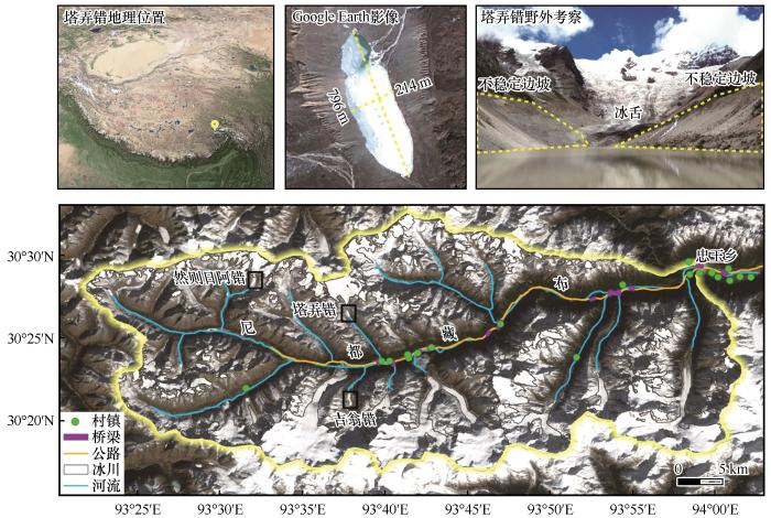
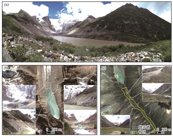
冰碛阻塞湖(简称冰碛湖)指以现代冰川融水为主要补给源,受冰碛垄阻塞在终碛垄与冰舌之间形成的湖泊[1]。随着全球气候变暖,冰川融水增加,为冰碛湖的扩张和发育提供了充足的空间和水源补给[2-4]。冰湖不仅是高山区重要的水资源,也是许多冰川灾害的孕育者和发源地[5-6]。冰湖溃决洪水(glacial lake outburst flood,GLOF)指冰湖中储存的大量水由于坝体垮塌或湖水漫顶、瞬间泄洪形成的突发性洪水[7]。已有记录表明大部分冰湖溃决洪水源自于冰碛湖,此类洪水具有突发性强、洪峰流量高、破坏性强、波及范围广等特点[8-10]。不仅可以直接破坏下游地区的基础设施,而且可能引发滑坡或泥石流等一系列次生灾害链[5-6,11]。青藏高原东南部自1935年以来记录已发生了近20次冰湖溃决洪水[10,12-13]。冰湖溃决洪水严重影响着承灾区居民的生命财产安全及寒区基础设施,现已成为制约山区可持续发展的重要因素之一[5,14]。
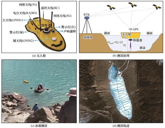
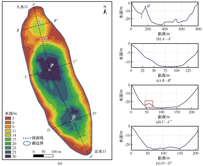
Fig. 3
Principles of glacial lake sounding and field water depth measurement: unmanned ship (a), principles of sounding (b), glacial lake sounding (c) and sounding track (d)
2.2 方法
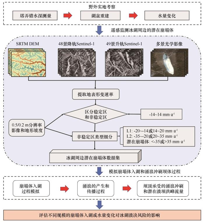
本研究主要基于塔弄错的野外水深测量数据重建了水量,根据地形地貌调查情况和SBAS-InSAR方法提取的流域地表形变速率,识别了冰湖周边的潜在崩塌体等诱灾因素。最后,基于数值模型RAMMS(rapid mass movement simulation)和波浪传播模型,评估了不同情景下崩塌体入湖和水量变化对冰湖溃决风险的影响。塔弄错的潜在溃决风险评估流程如图4所示。
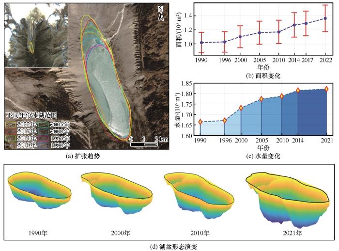
Fig. 6
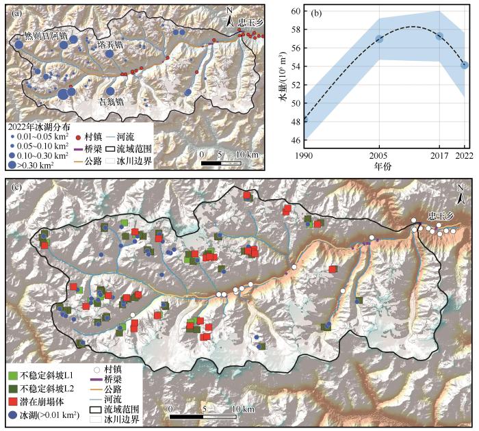
Dynamic evolution process of Tanong Co from 1990 to 2022: lake expansion trend (a), changes in lake area (b), changes in water volume (c) and lake basin morphological changes (d)
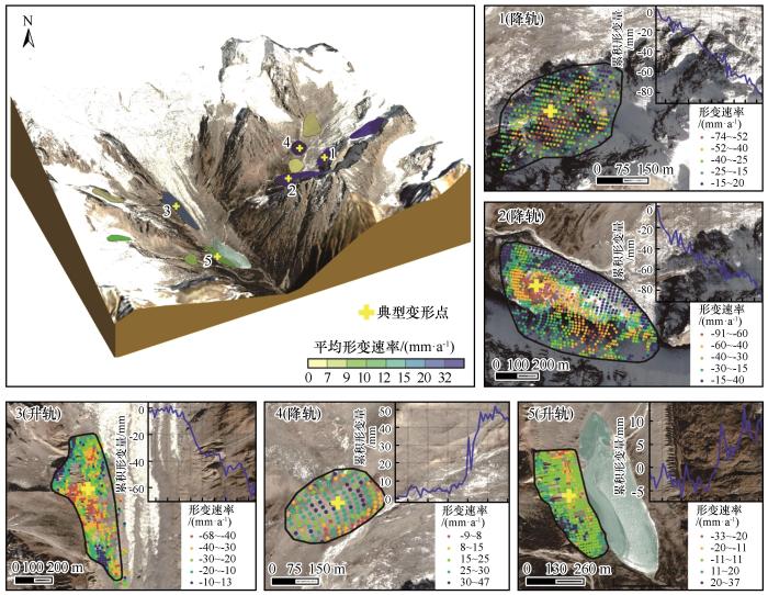
Fig. 7
Distribution of the potential collapse areas around Tanong Co (Regions 1, 2, and 4 are the descent data, and regions 3 and 5 are the ascent data) (The base images are from Google Earth imagery)
Table 2
表2
表2塔弄错周边潜在崩塌区的基本信息
Table 2 Basic information of the potential collapse areas around Tanong Co
编号
海拔/m
面积/m2
体积/m3
平均形变速率/
(mm·a-1)
最大形变速率/
(mm·a-1)
累积形变量/mm
离湖的直线距离/m
1
5 178
78 977
256 943
32
-75
-86
1 600
2
5 133
193 463
643 099
32
-92
-87
958
3
4 884
202 030
672 276
28
-67
-67
160
4
5 186
48 040
154 441
21
47
43
1 600
5
4 775
818 338
2 816 079
18
37
7.4
0
注:平均形变速率为绝对值。
Note:The average deformation rate is an absolute value.
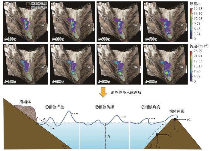
Fig. 8
Movement process of the debris flow entering Tanong Co and the propagation of an impulse wave (Fh1 represents the static water pressure experienced by the horizontal direction of the dam, Fh2 represents the total impact force of waves and static water pressure, and the schematic diagram is modified from Reference [33]; The base images are from Google Earth imagery)
Fig. 9
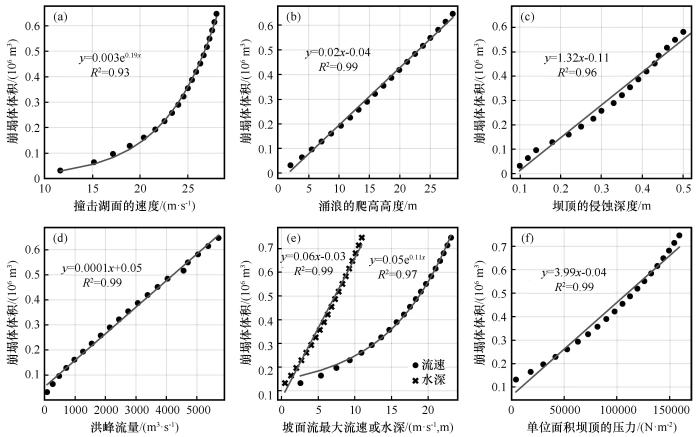
Relationships between collapse bodies of different size and important parameters of impulse wave propagation and dam erosion: collapse volume and impact velocity of the lake surface (a), collapse volume and impulse wave height (b), collapse volume and erosion depth of the dam top (c), collapse volume and peak discharge (d), collapse volume and maximum water depth of the overland flow (e), collapse volume and pressure of the dam top (f)
Fig. 10
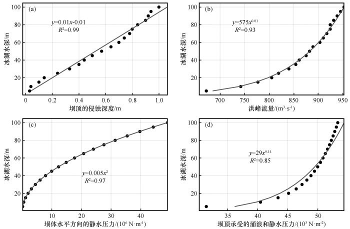
Relationships between different water depth and important parameters of impulse wave propagation and dam erosion: glacial lake depth and erosion depth of the dam crest (a), glacial lake depth and peak discharge (b), glacial lake depth and hydrostatic pressure of the dam crest (c), glacial lake depth and total pressure of the dam crest (d)
Fig. 11
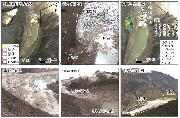
Cause of the Ranzeria Co dam breach and distribution of paraglacial slope failures around the lake: lake change (a), avalanche remains (b), unstable areas (c), glacier tongue disintegration (d), lake surface after GLOF (e) and the GLOF effects (f) (All the photos were taken by Professor Yao Xiaojun in 2017, and the base images are from Google Earth imagery)
Fig. 12
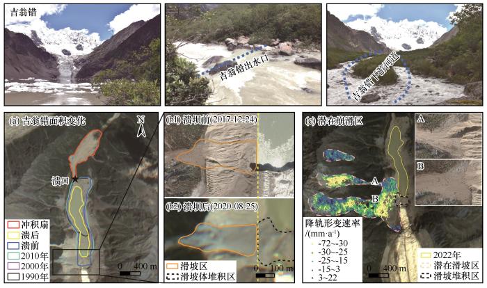
Cause of the Jiweng Co dam breach and distribution of paraglacial slope failures around the lake: changes in lake area (a), before and after dam failure (b1, b2) and potential lakeside collapse areas (c) (All the photos were taken by Professor Yao Xiaojun in 2017, and the base images are from Google Earth and ZY-3 satellite imagery)
Lake water and glacier mass gains in the northwestern Tibetan Plateau observed from multi-sensor remote sensing data: implication of an enhanced hydrological cycle
[J]. Remote Sensing of Environment, 2020, 237: 111554.
WangXin, LiuShiyin, DingYongjian. Study on evaluation method and application of moraine lake outburst disaster in Himalayan Mountains of China[M]. Beijing: Science Press, 2016.
Definition and classification systems of glacial lake for inventory and hazards study
1
2017
... 冰碛阻塞湖(简称冰碛湖)指以现代冰川融水为主要补给源,受冰碛垄阻塞在终碛垄与冰舌之间形成的湖泊[1].随着全球气候变暖,冰川融水增加,为冰碛湖的扩张和发育提供了充足的空间和水源补给[2-4].冰湖不仅是高山区重要的水资源,也是许多冰川灾害的孕育者和发源地[5-6].冰湖溃决洪水(glacial lake outburst flood,GLOF)指冰湖中储存的大量水由于坝体垮塌或湖水漫顶、瞬间泄洪形成的突发性洪水[7].已有记录表明大部分冰湖溃决洪水源自于冰碛湖,此类洪水具有突发性强、洪峰流量高、破坏性强、波及范围广等特点[8-10].不仅可以直接破坏下游地区的基础设施,而且可能引发滑坡或泥石流等一系列次生灾害链[5-6,11].青藏高原东南部自1935年以来记录已发生了近20次冰湖溃决洪水[10,12-13].冰湖溃决洪水严重影响着承灾区居民的生命财产安全及寒区基础设施,现已成为制约山区可持续发展的重要因素之一[5,14]. ...
冰湖的界定与分类体系: 面向冰湖编目和冰湖灾害研究
1
2017
... 冰碛阻塞湖(简称冰碛湖)指以现代冰川融水为主要补给源,受冰碛垄阻塞在终碛垄与冰舌之间形成的湖泊[1].随着全球气候变暖,冰川融水增加,为冰碛湖的扩张和发育提供了充足的空间和水源补给[2-4].冰湖不仅是高山区重要的水资源,也是许多冰川灾害的孕育者和发源地[5-6].冰湖溃决洪水(glacial lake outburst flood,GLOF)指冰湖中储存的大量水由于坝体垮塌或湖水漫顶、瞬间泄洪形成的突发性洪水[7].已有记录表明大部分冰湖溃决洪水源自于冰碛湖,此类洪水具有突发性强、洪峰流量高、破坏性强、波及范围广等特点[8-10].不仅可以直接破坏下游地区的基础设施,而且可能引发滑坡或泥石流等一系列次生灾害链[5-6,11].青藏高原东南部自1935年以来记录已发生了近20次冰湖溃决洪水[10,12-13].冰湖溃决洪水严重影响着承灾区居民的生命财产安全及寒区基础设施,现已成为制约山区可持续发展的重要因素之一[5,14]. ...
Lake water and glacier mass gains in the northwestern Tibetan Plateau observed from multi-sensor remote sensing data: implication of an enhanced hydrological cycle
1
2020
... 冰碛阻塞湖(简称冰碛湖)指以现代冰川融水为主要补给源,受冰碛垄阻塞在终碛垄与冰舌之间形成的湖泊[1].随着全球气候变暖,冰川融水增加,为冰碛湖的扩张和发育提供了充足的空间和水源补给[2-4].冰湖不仅是高山区重要的水资源,也是许多冰川灾害的孕育者和发源地[5-6].冰湖溃决洪水(glacial lake outburst flood,GLOF)指冰湖中储存的大量水由于坝体垮塌或湖水漫顶、瞬间泄洪形成的突发性洪水[7].已有记录表明大部分冰湖溃决洪水源自于冰碛湖,此类洪水具有突发性强、洪峰流量高、破坏性强、波及范围广等特点[8-10].不仅可以直接破坏下游地区的基础设施,而且可能引发滑坡或泥石流等一系列次生灾害链[5-6,11].青藏高原东南部自1935年以来记录已发生了近20次冰湖溃决洪水[10,12-13].冰湖溃决洪水严重影响着承灾区居民的生命财产安全及寒区基础设施,现已成为制约山区可持续发展的重要因素之一[5,14]. ...
Rapid worldwide growth of glacial lakes since 1990
Movement process of the debris flow entering Tanong Co and the propagation of an impulse wave (<i>F<sub>h</sub></i><sub>1</sub> represents the static water pressure experienced by the horizontal direction of the dam, <i>F<sub>h</sub></i><sub>2</sub> represents the total impact force of waves and static water pressure, and the schematic diagram is modified from Reference [<xref ref-type="bibr" rid="R33">33</xref>]; The base images are from Google Earth imagery)Fig. 8
... represents the total impact force of waves and static water pressure, and the schematic diagram is modified from Reference [33]; The base images are from Google Earth imagery)Fig. 8


 甘公网安备 62010202000676号