


0 引言
随着高寒地区重点工程的修建,降雨引发的多年冻土地区斜坡稳定性问题受到了广泛关注,已有学者通过模型试验、数值分析和现场监测等手段开展了降雨对冻土斜坡稳定性影响的研究。Vidie等[9]通过模型试验研究不同降雨强度对冻土斜坡失稳的影响,提出中等降雨会引起冻胀蠕变和小规模滑坡,强降雨会诱发规模大、速度快的滑坡和泥流;段东明等[10]采用数值模拟对多年冻土斜坡路基进行降雨入渗分析,得出降雨导致斜坡稳定性的减小存在一定滞后;Niu等[11]基于无限斜坡模型评估多年冻土斜坡稳定性,计算夏季降雨触发冻土浅层滑坡的临界地下水位;赵文等[12]开展模型试验研究冻土斜坡在反复降雨-日晒-冻融循环条件下的演化特征,认为冻融循环引起坡面土体密实度降低,松散土体在降雨过程中流失导致斜坡逐年后退。
1 青海省祁连县冻土浅层滑坡
1.1 地质环境特征
基于多源遥感数据调查青海省多年冻土区热融灾害分布,共解译冻土浅层滑坡灾害290处,在青海省祁连县、治多县和曲麻莱县广泛分布,结合现场调查验证,祁连县共发育有冻土浅层滑坡灾害54处,占青海省该类型灾害总数的18.6%。采用无人机航拍、动力触探和钻探等方式对祁连县冻土浅层滑坡开展了现场调查。
青海省祁连县位于祁连山中段腹地,地形呈北高南低、西高东低的特点,地貌类型较丰富。经统计,祁连县冻土浅层滑坡发育的海拔范围为3 550~3 850 m,主要集中在3 750 m;发育位置多为汇水沟中上部,斜坡坡度集中在10°~20°,整体上陡下缓,发育坡向多为阴坡;斜坡表层植被以异针茅和高山蒿草为主,上部植被较下部稀疏,植被总体覆盖率约50%~80%,滑体表层植被破坏严重;滑体表面由第四纪上更新统坡(洪)积物(Q3dl+pl)组成,下伏基岩主要为三叠系(T)砂岩,活动层土体主要为细粒黏土和泥炭,受冻融循环影响土体力学性质较差;后缘往往发育小型不规则陡坎,底部常有地下水汇集或地下冰出露;滑体向沟口流动堆积,前缘多发育有鱼鳞状草皮。
1.2 气候条件
青海省祁连县属于典型的高原大陆性气候,地形条件复杂和海拔梯度悬殊导致水热条件呈显著的区域性差异和垂直差异。东部降雨多、气温较高,西部降雨少、气温较低,低海拔地区的气温较高海拔地区高;年内气温变化符合正弦函数分布,1月平均气温达到最低值-11 ℃,7月平均气温达到最高值15 ℃;研究表明当地多年平均气温呈波动上升趋势,气温倾向率达0.33 ℃·(10a)-1[16]。
根据当地气象站资料可得:从祁连县降雨量月际分配来看,5—9月多年平均降雨量达到324 mm,占全年总量的84.6%,7月往往达到降雨量最大值;从祁连县降雨量的季节分配来看,夏季多年平均降雨量为234 mm,占全年降雨量的57.8%,秋季和春季平均降雨量分别占20.9%和17.8%,冬季仅占3.5%。研究表明近年来青海省祁连山地区降雨量呈波动上升趋势,尤其进入21世纪后,降雨量呈快速增大趋势,降雨量倾向率为46.3 mm·(10a)-1[17]。
1.3 滑坡概况
2018年8月末青海省祁连县默勒镇海浪村(100°49′58″ E, 37°43′47″ N)发生冻土浅层滑坡(图1)。现场调查表明,滑坡高程范围为3 763~3 800 m,平面呈不规则舌状,位于阴坡中下部,斜坡整体坡度约15°。根据运动及堆积特征将滑坡分为滑源区和流动堆积区,滑源区长32 m,流动堆积区长58 m。根据2020年10月10日钻孔资料获取滑坡地层信息(图2),地表以下0~1.6 m为活动层,由粉质黏土、砂质黏土和泥炭组成,其中0~1.4 m土层较松散,1.4~1.6 m土层相对致密;1.6~12.7 m为多年冻土层,由黏土和泥岩组成,含有大量冰晶;12.7~15.0 m为基岩层,主要为砂砾岩。结合现场调查和钻孔资料获取主滑方向地质剖面如图3所示。
图1
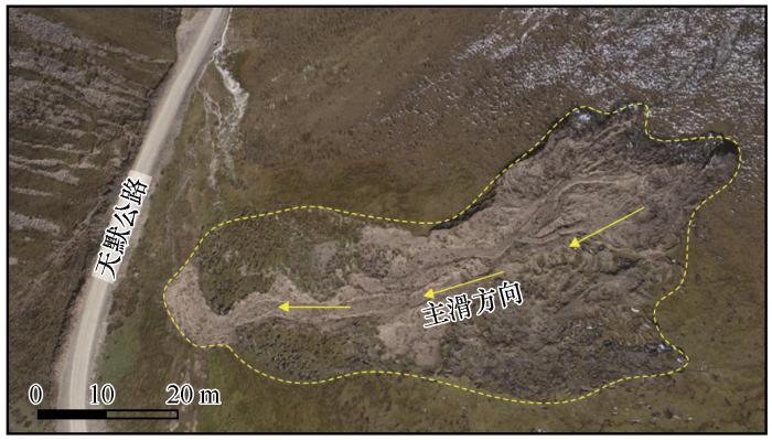
图2
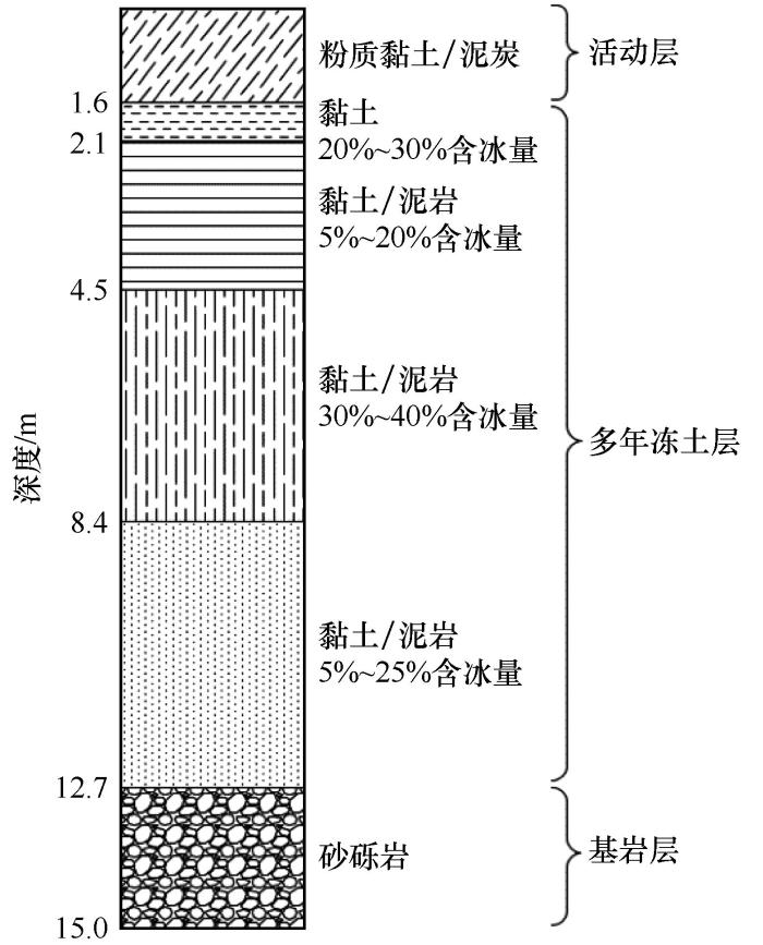
图3
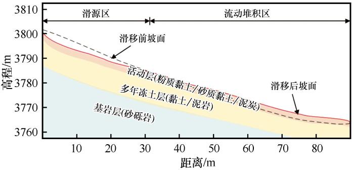
图4
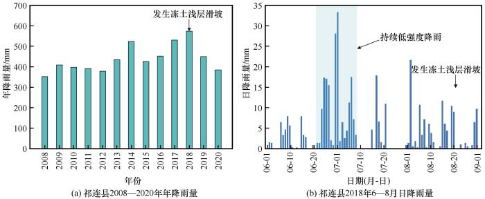
图4
青海省祁连县降雨概况
Fig. 4
Rainfall situation of Qilian, Qinghai Province: annual rainfall in Qilian from 2008 to 2020 (a); daily rainfall in Qilian from June to August in 2018 (b)
2 水热力耦合数值模拟
2.1 计算原理
基于有限元软件COMSOL Multiphysics求解多物理场偏微分方程,实现多年冻土斜坡气温变化和降雨过程中的水热力演化数值仿真,并用强度折减法计算斜坡稳定性[18]。鉴于气温变化和降雨对冻土浅层滑坡的影响是复杂的水热力动态耦合过程,为简化这一过程,假设入渗雨水温度与地表温度一致,温度场变化受热传递、水分运移和冰水相变影响;水分场变化由基质吸力驱动,并由孔隙冰阻隔作用控制;水热过程单向影响土体应力和位移。相应物理场控制方程如下:
(1)温度场方程
冻土二维传热中,忽略对流传热、考虑相变的温度场方程可写为[19]
式中:
(2)水分场方程
冻土中水分迁移规律与非饱和土中水的运移相似,用Richards方程描述[19]
式中:
(3)应力场方程
土体任意微元的平衡微分方程和土体位移-应变关系表达式可写为[21]
式中:
2.2 网格模型和计算参数
图5
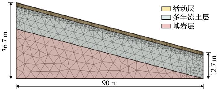
表1 地层物理力学参数
Table 1
| 参数 | 活动层 | 多年冻土 | 基岩 |
|---|---|---|---|
| 重度/(kN·m-3) | 18 | 20 | 25 |
| 弹性模量/MPa | 40 | 30 | 5 000 |
| 泊松比 | 0.25 | 0.3 | 0.15 |
| 饱和渗透系数/(m·s-1) | 2×10⁻⁶/4×10-9 | 8×10⁻¹⁰ | 0 |
| 黏聚力/kPa | 12 | 35 | / |
| 内摩擦角/(°) | 22 | 20 | / |
| 初始体积含水率 | 0.22 | 0.43 | 0.1 |
2.3 计算方案及约束条件
建立不考虑降雨的模型一和考虑降雨的模型二,对照分析降雨对冻土浅层滑坡的影响:模型一仅施加气温变化工况模拟斜坡10月10日至次年12月31日的水热力演化;模型二以模型一7月1日的水热力计算结果为初始状态,在气温变化的基础上施加强度9 mm·d-1、历时18 d的降雨工况,模拟斜坡7月1日至7月18日降雨过程中和7月19日至7月30日降雨停止后12 d内的水热力演化。
3 模拟结果与分析
3.1 降雨对温度场的影响
图6
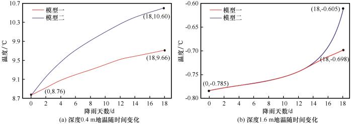
图6
降雨导致不同深度地温随时间变化
Fig. 6
Ground temperature at different depths varies with time caused by rainfall: ground temperature at a depth of 0.4 m varies with time (a); ground temperature at a depth of 1.6 m varies with time (b)
3.2 降雨对水分场的影响
图7为7月18日和7月30日模型一和模型二的含冰量云图,结果表明:7月18日模型一融深位于1.35 m,模型二融深位于1.49 m,降雨18 d导致模型二融深下降14 cm,多年冻土上限位置含冰量较模型一减小2.94%;7月30日模型一融深位于1.43 m,模型二活动层已完全融化,融深位于1.60 m,可见雨水渗流对土体含冰量产生持续影响,降雨停止后12 d模型二融深下降17 cm,模型二多年冻土上限位置含冰量较模型一减小40.74%。
图7
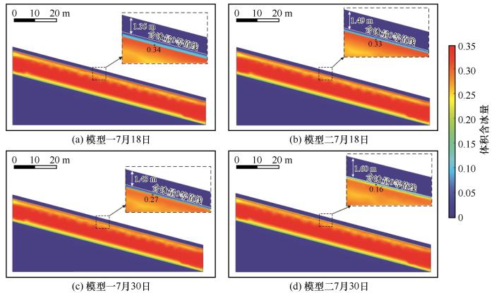
图7
7月18日和7月30日模型一和模型二含冰量
Fig. 7
Ice content of model 1 and model 2 on July 18th and July 30th
图8为7月18日和7月30日模型一和模型二的饱和度云图。7月18日模型一0~1.4 m为饱和度约0.58的融土层,活动层底部20 cm为饱和度约0.45的冻土层;7月30日模型一融深增大,冻土层厚度减小为10 cm,饱和度增至0.48。雨水入渗导致活动层饱和度大大增加,7月18日模型二融土层的饱和度约0.88,活动层底部13 cm为饱和度约0.45的冻土层;由于水分下渗和冻土进一步融化,7月30日活动层完全融化,饱和度约0.85,活动层基底以下形成10 cm厚饱和度约0.90的富水层。
图8
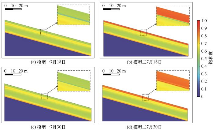
图8
7月18日和7月30日模型一和模型二饱和度
Fig. 8
Saturation of model 1 and model 2 on July 18th and July 30th
根据不同深度渗流速度随时间变化曲线[图9(a)]和降雨过程中流速分布[图9(b)],分析降雨条件下渗流速度变化规律如下:7月1日1.2 m深度内土体已完全融化,渗流速度随深度减小,此时融水沿坡面法向迁移,降雨0~3 d雨水入渗导致流速迅速增加,此时雨水渗透深度有限,流速增大速率随深度增大而减小;随着雨水继续下渗,自降雨3 d起,流速增大速率随深度增大而增大;1.4 m深度土体的孔隙冰在降雨9 d融化,流速开始增大;降雨9 d雨水沿重力方向竖直下渗,在孔隙冰的阻隔作用下,降雨18 d随土层深度增加,渗流方向愈发接近顺坡;降雨停止后,1.4 m深度范围内土体流速下降,此时流速随深度增大而增大;由于1.4~1.6 m深度为渗透性较差的相对致密层,1.6 m深度处流速在降雨停止后2 d才逐渐增大,且流速增量很小;降雨停止后12 d,渗流方向完全转变为顺坡。
图9
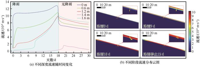
图9
降雨条件下渗流速度变化规律
Fig. 9
Variation of seepage velocity under rainfall condition: seepage velocity at different depths varies with time (a); distribution of seepage velocity at different stages (b)
3.3 降雨对斜坡稳定性的影响
图10(a)为模型一年内的安全系数变化曲线,可以得出斜坡稳定性与气温均呈正弦函数变化,且两者呈负相关,稳定性相对气温具有一定滞后,最高气温和最低气温出现在7月和1月,而8月和9月斜坡稳定性最差,2月稳定性最好,年内气温升高导致安全系数下降约12.1%。
图10
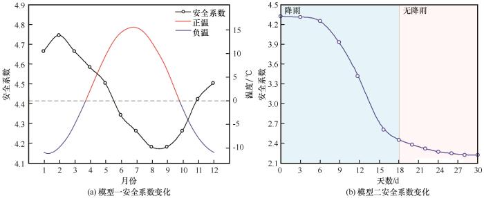
图10
模型一和模型二稳定性变化规律
Fig. 10
Variation of slope stability of model 1 and model 2: variation of safety factor of model 1 (a); variation of safety factor of model 2 (b)
图10(b)为模型二7月1日至7月30日安全系数变化曲线,结果表明:降雨导致安全系数下降约49.1%。降雨0~6 d安全系数缓慢下降,6~15 d安全系数下降趋势显著增大,安全系数从4.30下降至2.61,降雨15 d安全系数下降趋势逐渐减小,于降雨停止后10 d达到最小值2.22,此时斜坡仍处于稳定状态。
图11
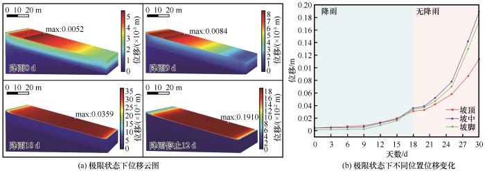
图11
极限状态下模型二位移变化规律
Fig. 11
Variation of displacement of model 2 under limit state: distribution of slope displacement under limit state (a); variation of slope displacement at different positions under limit state (b)
4 讨论
降雨18 d导致0.4 m深度地温升高0.94 ℃、1.6 m深度地温升高0.093 ℃,可见雨水入渗导致斜坡浅层地温升高,降雨对地温的影响随深度增加而减小。地温升高促进冻土融化,同一时刻降雨条件下活动层融深较大,降雨停止后12 d多年冻土上限附近含冰量减小40.74%。雨水入渗和冻土融化导致活动层饱和度提高77%~95%,降雨停止后12 d活动层以下出现了10 cm厚富水层。分析认为,降雨导致活动层融土含水量增加、容重增大,水分聚集对土颗粒产生动态浮托力[31],土体力学性质下降;7月1日至18日地表温度达到最大值,地温随深度增加而降低,雨水下渗过程中内能向温度较低的土体转移,且活动层饱和度上升提高了土的导热性,有利于大气与土体之间的热传导;降雨条件下融深可能进一步增大,活动层以下细粒富冰冻土层融化产生富水层,孔隙水压难以消散,土体有液化的可能[32],且水分的润滑作用削弱了冻融交界面的抗滑力[33],发生冻土浅层滑坡的风险大大增加。
极限状态下斜坡的位移集中在活动层,潜在滑面位于活动层和多年冻土交界面,符合冻土浅层滑坡变形特征。降雨初期水分沿重力方向下渗,此时位移缓慢增大;当雨水入渗量较大时,地下冰起隔水作用,导致渗流方向逐渐转变为顺坡,流速随深度增大而增大,同一深度斜坡中部流速最大,此时位移显著增大,最大位移所在位置由坡顶附近转移至坡中和坡脚之间。由此可见,降雨条件下融土达到一定饱和度后,活动层形成顺坡方向的渗流场,产生顺坡方向的渗透力[34],增大了上覆融土的下滑力,此时土体饱和度较高,力学性质降低,导致斜表变形加剧,增大了活动层沿多年冻土层滑脱的可能性。
斜坡稳定性与气温均以正弦函数形式变化,两者呈负相关,相关研究表明,气温对多年冻土斜坡稳定性的影响需要进一步考虑短时间尺度下的极端高温[35-36]和长时间尺度下的冻融循环作用[8]。施加降雨工况后,斜坡安全系数从4.30下降至2.22,下降幅度达48.4%,降雨入渗前3 d安全系数下降速率缓慢,3~15 d安全系数迅速下降,第15 d起安全系数下降速率逐渐降低,于降雨停止后10 d达到最小值,此时斜坡仍处于稳定状态,推测后续的降雨将进一步降低斜坡安全系数导致斜坡在8月末失稳。综上所述,降雨对多年冻土斜坡浅层稳定的影响显著,雨水入渗对多年冻土斜坡浅层水热力产生持续性的影响,在低强度、长时间的降雨工况下,斜坡最小安全系数出现时间滞后于降雨数天,斜坡可能在降雨停止后的数天失稳,推测此时斜坡的破坏形式为坡脚附近活动层最先沿冻融交界面薄弱层破坏,从而牵引上部土体下滑引起冻土浅层滑坡。
5 结论
通过COMSOL Multiphysics建立了多年冻土斜坡模型,在气温变化的基础上模拟了9 mm·d-1、持续18 d降雨条件下多年冻土斜坡水热力演化过程,基于模拟结果探讨了气温变化条件下青藏地区低强度、长持时降雨对冻土浅层滑坡失稳的影响,得出以下结论:
(1)夏季降雨扰动斜坡浅层温度场,影响了活动层的冻融过程,可能导致活动层以下含冰量较高的细粒土融化形成富水层,增大了斜坡因活动层基底孔隙水压力积累而失稳的风险。
(2)雨水入渗导致活动层饱和度大幅提高,增大了土体容重、削弱了土体力学性质,在多年冻土层隔水作用下水分沿顺坡方向迁移,产生顺坡方向的渗透力,加剧活动层变形,对多年冻土斜坡浅层稳定性产生威胁。
(3)降雨对多年冻土斜坡浅层稳定性产生的不利影响较明显,雨水入渗一段时间后斜坡稳定性迅速下降,且雨水入渗对活动层水热力的演化产生持续影响,安全系数最小值滞后于降雨数天。
(4)极限状态下斜坡位移演化规律印证了冻土浅层滑坡是活动层沿多年冻土层滑脱的过程,土体位移变化与雨水入渗形成的渗流场关系密切,低强度的持续降雨导致坡体中下部变形最显著。
参考文献
Relationships between climate warming and engineering stability of permafrost on Qinghai-Tibet plateau
[J].
青藏高原气候转暖与冻土工程的关系
[J].
Development of thawing hazards and thermal influence on permafrost along Qinghai-Tibet engineering corridor
[J].
青藏工程走廊典型热融灾害现象及其热影响研究
[J].
Review on climate change on the Tibetan Plateau during the last half century
[J].
Influence factors involving rainfall-induced shallow slope failure: Numerical study
[J].
7.31 hillslope processes in cold environments: An illustration of high-latitude mountain and hillslope processes and forms
[M]//
Permafrost and landslide activity: Case studies from southwestern Yukon territory
[J].
The distribution characteristics of permafrost along the Qinghai-Tibet Railway and their response to environmental change
[J].
青藏铁路沿线多年冻土分布特征及其对环境变化的响应
[J].
Frequency and magnitude of active-layer detachment failures in discontinuous and continuous permafrost, northern Canada
[J].
Physical modelling of rainfall- and snowmelt-induced erosion of stony slope underlain by permafrost
[J].
Stability analysis of Qinghai-Tibet Railway slope embankment in the event of rainstorm at the southern boundary region of the permafrost zone
[J].
暖季强降雨对多年冻土南界斜坡路基稳定性影响分析
[J].
Thaw-induced slope failures and stability analyses in permafrost regions of the Qinghai-Tibet Plateau, China
[J].
Experimental study on natural evolution characteristics of coarse-grained soil slope in seasonal frozen soil region
[J].
季节性冻土区粗颗粒土边坡自然演化特征试验研究
[J].
Mechanism of climate warming on thermal-moisture dynamics of active permafrost layer considering effect of rainfall
[J].
考虑降雨作用的气温升高对多年冻土活动层水热影响机制
[J].
A coupled model for liquid water, water vapor and heat transport of saturated–unsaturated soil in cold regions: Model formulation and verification
[J].
Quantitative evaluation of characteristic precipitation event (CPE)’s effect on hydro-thermal state of active layer in Beiluhe area
[J].
Spatiotemporal variation of air temperature in the middle and eastern parts of the Qilian Mountains and the nearby regions during the period of 1960—2014
[J].
1960—2014年祁连山中东段及其附近地区气温时空变化特征
[J].
Characteristics of precipitation change in Qilian Mountains during 1961—2019
[J].
1961—2019年祁连山地区降水变化特征分析
[J].
Stability analysis of slope based on dynamic and whole strength reduction methods
[J].
基于动态和整体强度折减法的边坡稳定性分析
[J].
Numerical study on moisture-heat-mechanics coupled process of Jiangluling Tunnel construction in permafrost region
[J].
多年冻土区姜路岭隧道施工水热力数值研究
[J].
Temperature distribution in roadbed of high-speed railway in seasonally frozen regions
[J].
季节性冻土地区高速铁路路基地温分布规律研究
[J].
A calculation method of thermal conductivity of soils
[J].
土体导热系数的评价与计算
[J].
Study on long-term stability of Qinghai-Tibet Railway embankment
[J].
A closed-form equation for predicting the hydraulic conductivity of unsaturated soils
[J].
Influence of slope seepage on thermal regime of Qinghai-Tibet highway in permafrost regions
[J].
斜坡渗流对青藏公路多年冻土路基温度场的影响
[J].
Temporal and spatial variation of air temperature in the middle Qilian Mountains in recent 58 years
[J].
近58年来祁连山中段气温时空变化
[J].
Study of the adherent layer on different types of ground in permafrost regions on the Qinghai-Xizang plateau
[J].
高原冻土区不同下垫面的附面层研究
[J].
Influence of lower boundary conditions on the numerical simulation of permafrost temperature field changes
[J].
下边界条件对多年冻土温度场变化数值模拟的影响
[J].
Analysis of sliding mechanism of accumulation horizon landslide under rainfall condition
[J].
降雨条件下堆积层滑坡体滑动机制分析
[J].
Geotechnical field observations of landslides in fine-grained permafrost soils in the Mackenzie Valley
[J].
Discussion on landslides hazard mechanism of two kinds of low angle slope in permafrost region of Qinghai-Tibet Plateau
[J].
青藏高原多年冻土区两类低角度滑坡灾害形成机理探讨
[J].
Reply to discussion on “On soil skeleton and seepage force”
[J].
对“论土骨架与渗透力”讨论的答复
[J].
Fluvial impact of extensive active layer detachments, cape bounty, Melville Island, Canada
[J].
An analysis of the stability of thawing slopes, Ellesmere Island, Nunavut, Canada
[J].

 甘公网安备 62010202000676号