

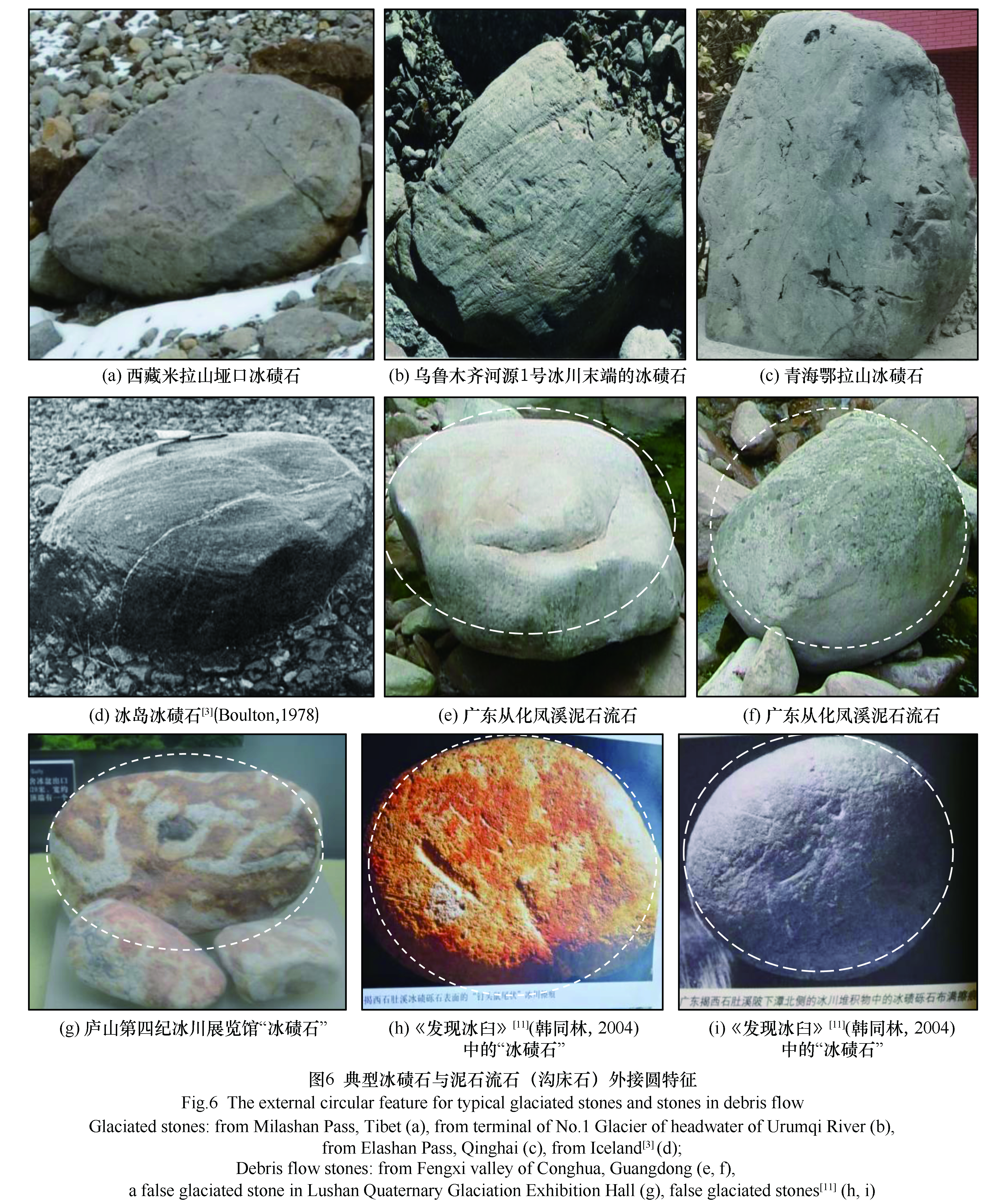
The sphericity and roundness of clasts have been used to distinguish glacigenic stones and other diamicton deposits for a long time, however, it is not enough to describe the subtle features among them. Therefore, it is necessary to further excavate the more discriminative indicator. Aiming to identify the glaciated stones and debris flow stones, several concepts are presented in this paper, including external circular feature, roughness feature, roundness-volume feature and their multimodal mixing characteristics in the diamicton deposits. These features, combining with other micro-morphological features, such as the glacial striations, glacial chatter marks, can be used to determine the origin of contentious deposition, especially in the eastern China. Meanwhile, the author hope that these suggestions will be corrected and improved in practice.
Based on evidences of periglacial landforms and deposits along Golmud and Yadong, and age constraint, this paper discusses the environmental characteristics of periglacial evolution on the North-South section of the central Qinghai-Tibet Plateau since the Last Glacial period. The evidences at Golmud show in LGM, the permafrost reaches at least 2 900 m above sea level, the annual average temperature drops to < -4 ℃, which was at least 9 ℃ lower than the present, and the climate is cold and dry; there are extremely dry and cold climate events in the deglaciation period and Holocene, and there may be a rapid cooling climate period in winter when the ground temperature was less than -10 ℃. The Ice wedge pseudophorms at Qumar River, Gulu (Naqu), and Nam Co recorded permafrost expansion during the Last Glacial period. The relict ice wedge at Yadong recorded early Holocene cold events. Palynological and dating evidences of the peat section at Yangbajing indicate that the area has experienced four climatic stages since the Younger Dryas event: severe cold (12.8~9.8 ka), warm and humid (9.8~5.0 ka), dry and cold (5.0 ka to present). The widely developed involutions, stratified slope deposits and eolian deposits in the study area are important evidences have the value of depicting temperature and precipitation variation for paleoenvironment reconstruction.
The evolution of cryosphere in the Tibetan Plateau (TP), which is closely related to the changes of water cycle, surface erosion, weathering and desertification, has exerted a profound influence on the Asian monsoon system and global climate. The grain size distribution of glacial deposits can provide important information on the formation and development of cryosphere in the TP. Up to date, however, the grain size composition and formation mechanism of moraines in the TP and their relationship with periglacial loess and fluviolacustrine sediments remain unclear. For this reason, a detailed grain-size analysis of the tills and glaciofluvial deposits in the Guliya ice cap, the largest ice cap on the TP, was carried out. It was found that the samples from the terminal moraine to the glacial outwash fan and a set of glaciofluvial deposits in the downstream rivers all show a characteristic bimodal size distribution, i.e. a 1~3 Φ medium-fine sand peak (500~125 μm) and a 6~8 Φ (16~4 μm) fine silt peak. The former may be produced by glacial crushing, frost weathering and breaking; the latter is mainly due to glacial abrasion. The lithology and grain size of the bedrocks in the source area exert also unignored influence. The contents of fine silt component of sediments from the moraine, outwash fan to the river beach generally show a decreasing trend. From the moraine, through glacial outwash fan, river to the lake beach at the entrance of the lake, the characteristic fine silt component of glacial abrasion shows a general decreasing trend. The lake dynamic sorting produces obvious enrichment of coarse and fine silts in the open lake, but they are almost completely blown away by the wind in the lake beach sediments, which directly become the dust source of the downstream loess and become the characteristic component of loess, The composition and source of silt, whether it is from the glacier-related tail lake deposits or from the near- or far-source loess deposits in the TP and its surrounding areas, can provide important information for revealing the formation and evolution of the plateau cryosphere.
Glacial troughs are one of the most typical glacial landforms distributed in glaciation areas. The study on their morphological characteristics and influencing factors helps to reveal the dynamic process of glacier development. Based on the V-index model and Matlab semi-automatic extraction method, this paper analyzed and discussed the developmental characteristics of glacier trough and valley morphology and the influencing factors of trough and valley morphology differences in the middle section of Tenasserim Mountains. The results show that there are 206 glacier troughs in the study area, most of which are U-shaped or slightly U-shaped, with a length of 4.5~26 km, an average width of 1.8 km, a depth of 200~500 m, and an altitude of 5 730~3 274 m.The transverse distribution of trough valley morphology is as follows: the V-index is more in the range of 0.2~0.3, and the valley with V-index greater than 0.3 developed in the northeast direction is more than that in the southwest direction, indicating that the erosion degree of trough valley in the eastern slope is stronger than that in the western slope. There are two trends of V-index along the longitudinal direction of the glacier trough. With the increase of V-index, the “U” shape of the cross-section of the glacier trough is gradually enhanced. V-index decreases, and the “U” shaped development of glacier trough and valley section weakens. The development of glacial troughs in the study area is dominated by lateral erosion, and the difference in morphology is due to the interaction of many factors, such as the characteristics of the glacier itself, the topography of the glaciation area and the lithology of the bedrock. Among them, the average slope of glaciation area, the average relief of topography and the area of palaeogeoliation area are the main factors causing the difference of distribution.
The Guxiang Glaciation is one of the most typical glaciations on the Tibetan Plateau during the Quaternary and has been widely used to represent the penultimate glaciation on the plateau. It was named from the frontal-lateral moraine at Guxiang, over 100 km down valley from the source area around the Guanxing Glacier, in the Bodui Zangbo River catchment in southeastern Tibet. Existing cosmogenic radionuclide 10Be surface exposure ages (~130 ka) show that the Guxiang Glaciation occurred during marine oxygen isotope stage 6, however, key information, such as ice volume, ice extent, and equilibrium line altitude (ELA) in the Bodui Zangbo River catchment during the Guxiang Glaciation, is an open question. In this study, we reconstruct the ice extent of the Guxiang Glaciation for the whole catchment on the basis of repeated field investigations, existing numerical dating results of moraines, and high-definition remote sensing images/satellite photos; estimate the ice volume and ice thickness using a glacier surface profile model run in Excel and ArcGIS software; and estimate the ELA of the catchment during the Guxiang Glaciation using the accumulation area ratio (AAR) and toe-to-headwall altitude ratio (THAR) methods. Our results show that during the Guxiang Glaciation, the total glacier area was 2 648 km2, the average glacier thickness was nearly 360 m, and the ice volume around 953 km3. The ice-cover rate has decreased from 63% in the Guxiang Glaciation to the present cover rate of 22.4%. Based on the paleo-glacier surface elevation interpolated with the inverse distance weighting method, the Guxiang Glaciation ELA is estimated to be 3 871 m, which is 584 m lower than the present ELA of 4 455 m. Our ELA estimation result is consistent with existing values.
The “Guxiang Glaciation” and “Baiyu Glaciation”, originated from Bodui Zangbo Valley, southern slope of eastern Nyainqêntanglha Range in southeastern Tibet, are the representative periods of Quaternary glaciations in Tibetan Plateau. Among them, Baiyu Glaciation (Last Glaciation) can be divided into early and late stages, and their corresponding glacial sediments are widely distributed in Bodui Zangbo Valley. Numerical dating of glacial deposits has suggested that the glacier advance during the late stage occurred in marine oxygen isotope stage 2 (MIS 2). However, the earlier glacial event has been lacking of effective chronology. Furthermore, whether this glaciation happened during MIS 4 or MIS 3 remains an open question. Based on previous researches and detailed field investigation, this study used optically stimulated luminescence (OSL) technique to date the moraines which have been suspected to construct during the early stage of Last Glaciation. The OSL ages range from (56.4±4.2) to (65.9±3.9) ka, corresponding to MIS 4. The ages could compare to other dated glacial advances in Tibetan Plateau and its surrounding mountains, suggesting this glacial event ever commonly occurred. Compared with summer insolation at 30° N and paleo-temperature and precipitation proxy records from regions dominated by India summer monsoon, it is likely that the reduced summer insolation at 30° N and decreased temperature caused the glacier expansion during MIS 4 in southeastern Tibet, not related to the summer monsoon and moisture.
Xiate River valley originates on the northeastern slope of Tumur-Hantengri Peak, the largest center of modern glaciation in the Tianshan Mountains, Central Asia. Four sets of glacial deposits are well preserved in this drainage. Dating these landforms allows for reconstruction of the spatial and temporal variations of glaciers in this valley. Five glaciofluvial samples (sand lenses sandwiched within the third moraine complex) were dated using optically stimulated luminescence with a single aliquot regenerative-dose protocol. The ages [(13.3±0.8)~(20.1±1.3) ka] show general agreement with the geological setting and field investigations. Based on the ages, geomorphic and stratigraphic investigation as well as the Quaternary glacial sequence in the adjoining valleys and available literatures of the whole Tianshan Mountains and western China (west of 105° E), we conclude that the first and second sets of moraines were formed during the Little Ice Age (the large glacial advances that occurred during cold periods since the 16th century) and Neoglaciation (glacial advances during the last 3~4 ka), respectively. The OSL ages demonstrate that the third moraine complex was deposited during the late period of the Last Glaciation, corresponding to marine oxygen isotope stage (MIS) 2. The deposits at the mouth of the Xiate River, the well-developed glacial trough indicate that a large compound valley glacier developed in this drainage, predate the Last Glacial Cycle. It is reasonable to infer that the fourth set of glacial complex was formed during MIS 6 glaciation. Since then, a pattern of restricted glaciations occurred after Penultimate Glacial Cycle in this valley and in the whole Tianshan Mountains.
As one of the few dating techniques which able to date glacial landforms directly, luminescence dating has been widely applied on glacial sediments, which in turn promoted great development of Quaternary glaciation. However, so far there is not a standardized protocol for glacial sediment luminescence dating, and thus lots of investigations are required in practical application. The most concerned issue is incomplete bleaching or partial bleaching of luminescence signal, i.e., the signal was not completely zeroed due to insufficient exposure prior to burial. For glacial sediments, the degree of bleaching of luminescence signal is closely related to geomorphological position and sedimentary environment. When sample glacial sediments for luminescence dating, several issues should be paid attention to: 1) Detailed geomorphological and sedimentological surveys, and selection of sampling sites; 2) Melt water deposits and periglacial eolian deposits, which are more suitable for luminescence dating than tills, but their relationship with glaciation has to be considered firstly; 3) Selection of glaciofluvial lens in moraines, which are currently considered as the best choice for determining chronology of Quaternary glaciation; 4) Vertical and horizontal distance consideration when sampling on moraines; 5) thanks to the development of rock luminescence dating, cobble is now one of the options for sampling for dating glacial landforms. There are also several key choices for laboratory luminescence (equivalent dose) measurement: 1) Sand size (coarse grain) quartz OSL dating is currently the preferred method for determining chronology of glaciation since the Last Glacial. 2) If the sample is older than the upper dating limit of quartz, or quartz is not suitable for measurement, K-feldspar elevated temperature post-IR infrared stimulated luminescence (post-IR IRSL) would be a good choice. 3) Single grain, small aliquot and rock luminescence burial dating technique have the potential to identify the bleaching condition, thus are most recommended options for glacial sediments at present. 4) If possible, try to use different minerals, different grain size, different methods for comparison and cross checking. Combination of geomorphology, sedimentology and chronology is strongly suggested to achieve the best luminescence ages of Quaternary glaciation.
Since the 1980s, with the development of high-energy accelerator mass spectrometry and the improvement of its analysis accuracy, terrestrial in situ cosmogenic nuclides (TCN) dating techniques has been rapidly developed and applied, and geochronology frameworks have been established in many disciplines. More and more facts demonstrate that the TCN dating techniques have revolutionized the development of geoscience. TCN dating techniques consist of dating target preparation, accelerator mass spectrometry (AMS) measurement, data analysis and others. The quality of dating targets preparation will directly affects the AMS measurement, and then affects the reliable chronological framework establishment and palaeo-environment reconstruction. The first step of dating target preparation is the high-quality sample collection; the second is the quartz extraction and purification; the third is the 10Be and 26Al separation and extraction; and final is the dating targets suppression. Here, we will take TCN radionuclides 10Be and 26Al, which are widely used in the Quaternary glaciations research as an example, combining with the distribution and characteristics of glacial erosional and depositional landforms, sample collection, quartz extraction and purification, 10Be and 26Al separation and extraction and dating targets suppression to discuss its application in the Quaternary glaciations research. This paper can provide theoretical guidance for the TCN dating target preparation for the new scholars to study the Quaternary glaciations, and can also provide reference for the scholars in other geoscience fields to apply this dating techniques.
The late Miocene-Pliocene ecological evolution has been a hot topic in discussing the interaction of tectonic, climate and ecological environment. However, whether the C4 plants in middle and low latitudes expanded on a large scale and how the ecology evolved on the time-space dimension are still debated. In this paper, based on the organic carbon isotope, the plant ecotype during the interval of 6.7~3.6 Ma covered on Xiaoshuizi area in the northeastern Tibetan Plateau were reconstructed and combined with the surrounding regions, the ecotype and its evolution were discussed. Our results show that the Xiaoshuizi area is dominated by C3 vegetation during the late Miocene-Pliocene (with an average abundance of 95%), accompanied by a small part of C4 vegetation. In space, the abundance of C4 vegetation in the eastern Liupan mountain is higher than that in the western, and in the north-south direction the C4 plant abundance reached the at about 37°~38° N. In terms of time series, ecological evolution of Xiaoshuizi planation surface is roughly consistent with that of the Chinese Loess Plateau before 4 Ma. It shows during the late Miocene C4 vegetation content is relatively high and C3 vegetation content is low, while C4 vegetation reduced and C3 vegetation increased in early Pliocene. The variations of atmospheric CO2 concentration and regional aridification may be the main influence factor for the vegetation evolution. The tectonic activities in the planation surface area may lead to the differential evolution of C4 vegetation in the Xiaoshuizi area.
In recent years, with the development of DNA sequencing technology, biogeography research on the Tibetan Plateau and surrounding areas has provided us with biological evidence for understanding the plateau uplift and its climatic effects. Based on recent advances in geology and biogeography, the origin of alpine biota in the plateau and surrounding areas suggests that alpine ecosystems existed in parts of the Tibetan Plateau as early as the Oligocene, and the geomorphology and climate of the Tibetan Plateau have undergone major changes since the late Miocene. The ancestors of these alpine species migrated to the rapidly rising plateau or evolved in situ endemic species adaptation to high-elevation habitats. The accelerated differentiation and formation of species since the late Pliocene may result from glacial action and geographical isolation, which caused by the formation of the huge plateau mountain and river system. The alpine biota of the Tibetan Plateau and surrounding areas are closely related to the high latitudes of the Northern Hemisphere. Biogeography research also indicated that no large ice sheet covered the entire Tibetan Plateau and there are still nature refuges on the plateau during the Quaternary. Geology, paleontology, and evolutionary biology should be integrated in a holistic way in order to fully understand the history of the uplift of the Tibetan Plateau and its climatic effects.
As the critical stage from the Pliocene to the Quaternary, the Pliocene-Pleistocene transition during the interval of 3.0~2.2 Ma obviously experienced climate change from warm climate to the Pleistocene glacial-interglacial cycles. Meanwhile, the Tibetan Plateau also experienced intensive tectonic uplift, the ecological environment and geomorphologic pattern of the Tibetan Plateau and its surrounding areas have been significantly shaped. So the detailed research on the paleoenvironment evolution during the Pliocene-Pleistocene transition can shed new lights on the coupled relationships among the atmosphere, biosphere and lithosphere. The Lanzhou Basin is the ideal place to discuss the interactions between the tectonic uplift, global cooling and regional ecosystem. Here the Gaolanshan red clay-loess sequence from the Lanzhou Basin were detailed analyzed via the n-alkanes distribution and organic geochemistry (total organic carbon and long-chain n-alkanes carbon isotopes) methods. Particularly, the C3/C4 relative abundance evolution history during the interval of 3.0~2.2 Ma in Lanzhou Basin were reconstructed. In detail, the n-alkanes of Gaolanshan red clay-loess sequence during the interval of 3.0~2.2 Ma mainly be characterized with unimodal pattern and the C31 main peak, which implicates the contribution of grassland vegetation. In addition, the n-alkanes distribution of typical loess L32 and L33 show the existence of double bulge, obviously implicating the microbial activities. After the integration of total organic carbon isotope, long-chain n-alkanes carbon isotope and grain sizes, we proposed that organic carbon isotope could be affected by exogenous input via the mixing n-alkanes by the wind. Therefore, we suggested that the total organic carbon isotopes should not be used to reconstruct the C3/C4 relative abundance during the Pliocene-Pleistocene transition in the Lanzhou Basin. Based on the integrated evidence of classical proxies and leaf wax compound-specific carbon isotope, the Gaolanshan paleoecology during the interval of 3.0~2.2 Ma was dominated by the C3 vegetation except the short C4 expansion before 2.9 Ma. It is obvious that the C4 vegetation sharply decreased near 3.0 Ma, possibly correlated with global cooling.
The chronology of Xijin loess section on the southern bank of the Yellow River in Lanzhou Basin was already founded reliably, thus, which was selected as a carrier to deeply study the Quaternary climatic evolution in the western Chinese Loess Plateau. The 417 samples at the same intervals were measured with a Minolta CM-700D spectrochromometer, and the record sequence of chromatic proxy in the Xijin section was obtained since 2.2 Ma ago. The results show that the climate evolution has undergone an overall trend of gradually drying and cooling since 2.2 Ma, with the published records of other paleoclimate proxies, the surrounding area and global stacked deep-sea δ18O, and which may indicate the impact of the global climate cooling during the Quaternary. Moreover, two significant climatic events were also found at about 1.24 Ma and 0.43 Ma. The winter and summer monsoons were synchronously strengthened after the event at 1.24 Ma, which was consistent with the beginning time of Kun-Huang Movement. This event may be driven by the uplift of the Tibetan Plateau. However, the event at 0.43 Ma in Lanzhou area is sensitively responsible for the global Mid-Brunhes Event (MBE). It is also shown that Quaternary climate evolution in Lanzhou area may have been regulated by both the uplift of the Tibetan Plateau and global cooling, and both impacts to different climate events may be different.
Two typical loess-paleosol sequences (KS16 and LJW10), located in the Tianshan region of Xinjiang in the eastern Arid Central Asia (ACA), were selected to reconstruct the climatic and environmental evolution during the Holocene. The susceptibility parameters (χARM/SIRM), lightness (L*), organic carbon/nitrogen isotope (δ13Corg and δ15N) of the KS16 section (43°25′56″ N, 83°56′35″ E, 1 314 m a.s.l.) in the Ili Basin were analyzed comprehensively. In addition, we combined the δ15N of LJW10 section (43°58′29″ N, 85°20′10″ E, 1 462 m a.s.l.), located in the northern Tianshan Mountains, and the proxies (χARM/SIRM, L*, δ13Corg, δ15N,) of KS16 section to reconstruct regional climatic and environmental evolution during the Holocene, which is helpful to understanding the synergistic effects of climate change and ecological environment in the eastern Arid Central Asia. The results show that: During the early Holocene, the χARM/SIRM and L* both indicated the pedogenesis was relatively weak and the organic matter content was low in the loess, with positive δ13Corg showed regional precipitation was limited, which reflected the low vegetation coverage and relatively arid climate environment during this period. During the middle and late Holocene, the variations of χARM/SIRM, L* and δ13Corg showed the moisture gradually increased, and the δ15N record presented more positive, which all indicated that the climatic optimum occurred at this period. The climatic and environmental characteristics of the eastern Arid Central Asia during the Holocene are closely related to the variations of the high latitude ice sheet and the intensity of insolation in northern hemisphere.
The Longzhong Basin is the front of the Tibetan Plateau expanding to the northeastern. The study of its landscape evolution plays a significance role for understanding the process and mechanism of the Tibetan Plateau uplift. In this paper, we date several different main planation surfaces in the Longzhong Basin and its surrounding area through in-depth summary of lots of previous researches and our new data. Moreover, we quantitatively evaluate the uplift of the main planation surfaces using reconstruction of relict landscape channel profiles. Our results suggest that these low-relief, high-elevation surfaces in the Longzhong Basin and its surrounding area are identified as elevated, preexisting low-relief planation surfaces, not in situ formation of low-relief landscape patches. The main planation surfaces have been developed synchronously. They began to develop since the Late Oligocene, and disintegrated at 8~6 Ma. The simulation results show that the Meiwu planation surface has been uplifted about 1 400~1 600 m relative to the Longzhong Basin since the Late Miocene. And the uplifting rate since Early Pleistocene is significantly higher than that during the interval of Late Miocene-Early Pleistocene.
Multi-layered interaction of the Tibetan Plateau is elusive and becoming a hotspot of geosciences. The key issue is to make clear the coupling of external/internal forces in each terrane. The West Qing orogenic belt is regarded as the northeasternmost spreading frontier of the plateau growth during the Cenozoic era, and the planation surfaces are well preserved in the mountain tops and argued as the precious coupling records of external/internal forces which related to the plateau formation and evolution. Therefore, to study the planation surfaces of West Qinling can provide the boundary conditions for our understanding the whole growth process of Tibetan Plateau. Mainly based on the geomorphologic factors and visual interpretation techniques, combining with the field investigation and existed geological and morphological information, we first quantitative analyze the levels, distributions and characters of the relict planation surfaces and finally illustrated in a map. The higher level of relict landscapes exists in the mountain summits with altitudes at 4 100 m in the west portion and then gradually changed to 3 600 m in the northeast parts. And the lower level of relict landscapes distributes on the mainly body of West Qinling, with altitudes from 3 600 m in the west portion to 2 700 m in the northeast. The northeastward tilt of these surfaces implying that the uplift amplitude of the Tibetan Plateau is gradually lower from center to margin. Compiling the previous study of low-temperature thermochronology and other morphotectonic evidences, we speculate that the higher and lower landscape remnants developed at low elevation during quiescent periods of orogenic building-up (which mainly occurred at 66~47 Ma, 38~22 Ma and ≤13 Ma), at the age ranges of middle Eocene and early-middle Miocene, respectively. By synthesis the yielded data here and the existed records of deformation and paleoaltimetry, a regional up-to-date morphotectonic scenario through the Cenozoic is finally reconstructed. Our study demonstrates that far-field stress due to the India-Asia collision propagated to the modern northeasternmost boundary as early as Paleocene. Subsequently, the topography of West Qinling developed through discrete steps of tectonic uplift activity/quiescence or enhanced erosion until the late Miocene, when the modern morphology of northeasternmost plateau finally formed. Typically, the formation of higher and lower planation surfaces occurred at about 47 Ma and 22 Ma, respectively. They should be firstly eroded to low altitude (<1 500 m) during the quiescence time intervals, and finally involved into the present Tibetan morphology by the Qingzang Movement. Our study supports the ideas that the growth of the Tibetan Plateau is synchronously with multiple-stages.
The challenge to understanding fluvial response to climate change and surface uplift is a thorough distinguishing between their roles within terrace formation, which can provide an excellent insight to the landform and drainage evolution in catchment scale. Previous studies tend to correlate terrace development with climate change or surface uplift separately, attributing deposition-lateral erosion and incision to glacial-interglacial climate, or regarding fluvial terrace even as a direct evidence of surface uplift. A preliminary explanation for the terrace development of the middle reaches of Yellow River is proposed by linking its upper and lower reaches. In comparison with the past work, river terrace here is considered as a combination result of fluvial response to climate change and relative surface uplift. Intermittent downcutting by the middle reaches of Yellow River on the uplifted Ordos Block and Emei Platform relative to the subsiding Fenwei Basin has created 7 terrace staircases and a sequence of 6 aggradational terraces, respectively,during the past 1.2 Ma. The analysis of loess stratigraphy combined with geochronology revealed that these terraces were overlaid directly by a basal paleosol layer on the fluvial sediments, indicating that the abandonment of these treads due to incision by the Yellow River occurred at the transition from glacial to interglacial climates. This suggests that the glacial-interglacial climate cycle probably has a temporal control on the terrace generation by determining the fluvial behavior alternation between deposition-lateral erosion and incision, even though the Yellow River develops in the subsiding Fenwei Basin. Remarkably, terrace records however are absent at some transitions from glacial to interglacial climate, indicating that climate cycle may not be the only decisive factor for terrace occurrence. The terrace generation may be sporadic and in the form of unusual stacked pattern before the Emei Platform was uplifted within the eastern Fenwei Basin. And when the Ordos block were uplifted slowly relative to the Fenwei basin, terraces seem to only be created by the middle reaches of Yellow River at these transitions from extremely dry glacial to interglacial. In contrast, the terrace staircases almost occurred in synchrony with glacial-interglacial climate cycles as they were uplifted fast enough relative to the Fenwei Basin. This contrastive pattern indicates that surface uplift may be necessary in large terrace staircase genesis. It can force river to downcut deeply enough during climatic transitions to separate terrace levels adequately, favoring the generation and subsequent preservation of the terrace tread. Based on above analysis, the terrace sequences created by the middle reaches of Yellow River can therefore be regarded as a combined archive of climate change and relative surface uplift.
The research of glacier mass balance has important guiding significance for the allocation and utilization of water resources in the basin. Glacier meltwater originating from the Qilian Mountains is an important source of fresh water in the Hexi Corridor and Qaidam Basin. In recent years, the glaciers in the Qilian Mountains retreated in varying degrees, and retreat rate was relatively high in the eastern section. We observed the mass balance of Ningchan No.1 (NC01) Glacier for 10 consecutive years in Lenglongling region of the eastern Qilian Mountains since 2010. Combining with high-resolution historical Google Earth imagery, ZiYuan-3 and Sentinel-2 satellite imagery, and weather data, we found that the front position of NC01 Glacier retreated from 2008 to 2020 with a rate of 7.54 m·a-1. The area of NC01 Glacier decreased with a rate of 0.075×10⁵ m2·a-1 from 2008 to 2020, and decreased to 3.32×10⁵ m2 in 2020. The NC01 Glacier remained negative mass balance from 2010 to 2020, with an average annual mass balance of -0.98 m w.e. According to the calculation, the average thickness of the glacier decreased to 17.52 m and the ice volume decreased to about 6.83×10⁶ m3 in 2020. The NC01 Glacier thinned continuously since 1972, and the mass loss rate during 2010—2020 is higher than that during 1972—2010, showing a relatively obvious acceleration trend, which may also be related to the significant increase in air temperature in recent years.
Cryoconite is black or brown spherical aggregates on the surface of glacier ablation areas, which is an important sink for microbe and dissolved organic matter (DOM) accumulated in supraglacial environments. Therefore, cryoconite plays an important role in glacier mass and energy balance, and biogeochemical cycle (especially the carbon cycle). During the ablation season, the concentration and characteristics of supraglacial DOM changes dynamically which are influenced by the environmental conditions and microbial activity. This study characterized the evolution of DOM from cryoconite throughout a 18-day in situ incubation experiment in the ablation zone of Laohugou Glacier No.12 and applying comprehensive analyze method as follows: dissolved organic carbon (DOC) analysis, UV-visible spectroscopy (UV-vis) analysis and electrospray ionization coupled with Fourier transform ion cyclotron resonance mass spectrometry (ESI FT-ICR MS) analysis. The results show that the concentration of DOC in cryoconite water decreased significantly from 13.41 mg?L-1 to 4.47 mg?L-1 during the early incubation (from day 0 to day 6), but then gradually increased to 6.71 mg C?L-1 during the late incubation (from day 6 to day 18). The value of SUVA254, which was used to analyze the effect of the coupled ‘photo-biological’ influence on the light absorption of DOC during the incubation period, was also decreased firstly and then increased significantly, indicating both of the concentration of DOM and the content of light absorbing compounds increased during the long-term incubation due to the light and microbial affect. The changes of DOM composition analyzed through ESI FT-ICR MS suggested that during the whole incubation period (from day 0 to day 18) the contents of peptides and lipids were reduced, while the contents of unsaturated, aromatics and condensed aromatics were increased. The changes of unique DOM composition in day 0, day 6, day 9 and day18 revealed that the composition of DOM in cryoconite continuously transformed from aliphatics and peptides to unsaturated, aromatics and condensed aromatics by the coupled ‘photo-biological’ transformation.
Under the background of global change, the cryosphere and atmosphere over the Tibetan Plateau (TP) are changing rapidly, which seriously affects the ecological environment of “Asian Water Tower” and “the Third Pole”. This paper reviews some issues in the research on climate change over the TP in recent years, including the change of extreme climate events over the TP and its relationship with the atmospheric circulation, the amplified warming and the physical mechanism of elevation dependent warming, applicability of modern reanalysis data, the bias and inaccuracy of climate models in the areas with scarce data over the TP, and the projection and risk study of climate change over the TP under the different warming threshold. Finally, some important issues and associated scientific challenges in the study of climate change over the TP are identified and their prospects are discussed. Addressing these will support the implementation of the Belt and Road Initiative.
The Arctic has a unique geographical location and strategic position, and it has become a hotspot for global change. The Arctic warming is more than twice than the global mean, which is called Arctic amplification. Under the background of rapid warming, the Arctic cryosphere has undergone strong changes, which have profound impacts on the Arctic climate and even the mid-latitude climate. This study summarizes the spatial and temporal characteristics and future projections of the main elements of the cryosphere (including sea ice, Greenland Ice Sheet, glaciers, snow and permafrost) under the background of rapid Arctic warming. At the same time, the impacts of cryospheric changes on the Arctic climate system (atmosphere, hydrosphere, lithosphere and biosphere) and extreme weather and climate events in mid-latitudes are reviewed. It is pointed out that the current research on the Arctic climate system still suffers from the insufficient observational data and the uncertainty of model simulations. Mechanisms responsible for the Arctic climate system and the ways in which the Arctic cryosphere influences the mid-latitudes are still controversial. This study motivates further effort to further develop the monitoring system for the Arctic, improve models’ ability to realistically represent the components and physical processes of the Arctic climate system, and conduct integrated research based on multi-data, multi-methods, and multi-models.
Tree cores of Sabina saltuaria individuals in Haizi Mountain, Daocheng, Sichuan province were obtained and cross-dated. Consequently, standard ring width (STD) chronology in the upper tree line of Sabina saltuaria were established by using ARSTAN program. It was indicated that tree growths in this area were restricted by the temperature of early growing season. The correlation between mean temperature from last September to current February (MTp9-c2) and the STD chronology was statistically significant (R=0.56, P<0.01), and the correlation was consistent with the biological characteristics of tree growth. Thereby, the 170-year (MTp9-c2) variation in this area from 1850—2019 was reconstructed and the percentage of explained variance of transform function was 31.7%. The reconstruction was closely matched with the temperature variation recorded by neighboring tree ring records. The reconstruction sequence showed that the colder periods experienced in this area were 1870—1890 and 1960—1980 respectively; the warmer periods were 1884—1892, 1680—1700, 1919—1925, 1940—1960 and 1980—2019. The period of 1940—1960 was the warmest period in the 20th century and the temperature has been declined since 1960s. Afterwards, the temperature kept rising from 1980 and decreased mildly after 2010. The reconstructed temperature series was coinciding with the sunspot’s number and the AMO index (Atlantic Multidecadal Oscillation), which revealed that some factors such as solar activity and sea surface temperature might exert an important influence on local temperature change.
Significant spatial heterogeneity exists in the trade-offs and synergies among ecosystem services (ESs). Rare studies have analyzed it from the aspect of socio-ecological environment, thus failed to integrate ESs into ecosystem management. Using Qilian Mountains as the study area, we have quantified six critical ESs (carbon storage, carbon sequestration, water yield, soil retention, nutrient retention and habitat quality) through InVEST model and CASA model, then explored the spatial heterogeneity of ES trade-offs and their response to socio-ecological environment through multivariate regression tree. The results suggested that synergies exist among these six ESs at regional scale, which were mostly impacted by land use pattern, precipitation and vegetation coverage. ESs in regions covered by vegetation were higher than the one without vegetation coverage. The whole region can be divided into five ES bundles, while the interactions among ESs differed in different bundles. Specially, significant synergies among six ESs in ES bundle 1 (areas without vegetation coverage and annual precipitation lower than 440.2 mm) and ES bundle 5 (non-cropland areas with higher vegetation coverage than 0.559). Increased precipitation would drive the trade-offs between the two ESs of water yield and soil retention and other four ESs in areas without vegetation coverage, while ES relationships tended to weaken in areas with lower vegetation coverage or in cropland. The results could provide useful suggestions for ecological management and decision making.
