State of the art and prospect of Geocryology in China
1
1988
... 冻土是地球五大圈层之一的冰冻圈系统的主要组成部分.它的存在、 分布以及水热状态对地气能水交换、 碳循环、 流域生态水文过程和工程建筑等产生重要的影响[1-8].在气候变化的背景下, 冻土温度和冻土分布的时空变化受到了广泛的关注[9-13], 它们既是寒区生态环境与碳循环研究[14-16]、 工程选址与设计的基础[17-21], 也是区域工程运行和资源综合规划管理的依据[22-23], 对我国生态文明建设与经济规划的实施具有重要的现实意义. ...
中国冻土学的现状和展望
1
1988
... 冻土是地球五大圈层之一的冰冻圈系统的主要组成部分.它的存在、 分布以及水热状态对地气能水交换、 碳循环、 流域生态水文过程和工程建筑等产生重要的影响[1-8].在气候变化的背景下, 冻土温度和冻土分布的时空变化受到了广泛的关注[9-13], 它们既是寒区生态环境与碳循环研究[14-16]、 工程选址与设计的基础[17-21], 也是区域工程运行和资源综合规划管理的依据[22-23], 对我国生态文明建设与经济规划的实施具有重要的现实意义. ...
Climate change and the permafrost carbon feedback
0
2015
Crystallization deformation of a saline soil during freezing and thawing processes
0
2017
Impacts of climate warming on the frozen ground and eco-hydrology in the yellow river source region, china
0
2017
Impacts of permafrost on above- and belowground biomass on the northern Qinghai-Tibetan Plateau
0
2018
Soil organic carbon and total nitrogen pools in permafrost zones of the Qinghai-Tibetan Plateau
0
2018
Effects of freezing thawing cycles on mechanical properties of loess solidified by sodium silicate
0
2018
冻融循环对硅酸钠固化黄土力学性质的影响
0
2018
Recent advances in frozen ground engineering geology survey along the China-Russia crude oil pipeline route (Mo’he-Daqing Section)
1
2008
... 冻土是地球五大圈层之一的冰冻圈系统的主要组成部分.它的存在、 分布以及水热状态对地气能水交换、 碳循环、 流域生态水文过程和工程建筑等产生重要的影响[1-8].在气候变化的背景下, 冻土温度和冻土分布的时空变化受到了广泛的关注[9-13], 它们既是寒区生态环境与碳循环研究[14-16]、 工程选址与设计的基础[17-21], 也是区域工程运行和资源综合规划管理的依据[22-23], 对我国生态文明建设与经济规划的实施具有重要的现实意义. ...
中国 - 俄罗斯原油管道工程(漠河 - 大庆段)冻土工程地质考察与研究进展
1
2008
... 冻土是地球五大圈层之一的冰冻圈系统的主要组成部分.它的存在、 分布以及水热状态对地气能水交换、 碳循环、 流域生态水文过程和工程建筑等产生重要的影响[1-8].在气候变化的背景下, 冻土温度和冻土分布的时空变化受到了广泛的关注[9-13], 它们既是寒区生态环境与碳循环研究[14-16]、 工程选址与设计的基础[17-21], 也是区域工程运行和资源综合规划管理的依据[22-23], 对我国生态文明建设与经济规划的实施具有重要的现实意义. ...
Climate warming over the past half century has led to thermal degradation of permafrost on the Qinghai-Tibet Plateau
1
2018
... 冻土是地球五大圈层之一的冰冻圈系统的主要组成部分.它的存在、 分布以及水热状态对地气能水交换、 碳循环、 流域生态水文过程和工程建筑等产生重要的影响[1-8].在气候变化的背景下, 冻土温度和冻土分布的时空变化受到了广泛的关注[9-13], 它们既是寒区生态环境与碳循环研究[14-16]、 工程选址与设计的基础[17-21], 也是区域工程运行和资源综合规划管理的依据[22-23], 对我国生态文明建设与经济规划的实施具有重要的现实意义. ...
Assessing permafrost degradation and land cover changes (1986 - 2009) using remote sensing data over Umiujaq, sub-arctic Québec
0
2015
Global distribution of cryosols with mountain permafrost: an overview
0
2015
Numerical mapping and modeling permafrost thermal dynamics across the Qinghai-Tibet Engineering Corridor, China integrated with remote sensing
0
2018
Data-driven mapping of the spatial distribution and potential changes of frozen ground over the Tibetan Plateau
1
2019
... 冻土是地球五大圈层之一的冰冻圈系统的主要组成部分.它的存在、 分布以及水热状态对地气能水交换、 碳循环、 流域生态水文过程和工程建筑等产生重要的影响[1-8].在气候变化的背景下, 冻土温度和冻土分布的时空变化受到了广泛的关注[9-13], 它们既是寒区生态环境与碳循环研究[14-16]、 工程选址与设计的基础[17-21], 也是区域工程运行和资源综合规划管理的依据[22-23], 对我国生态文明建设与经济规划的实施具有重要的现实意义. ...
The seasonal variation of ecosystem respiration in different vegetation types in the permafrost regions of Qinghai Tibet Plateau
1
2018
... 冻土是地球五大圈层之一的冰冻圈系统的主要组成部分.它的存在、 分布以及水热状态对地气能水交换、 碳循环、 流域生态水文过程和工程建筑等产生重要的影响[1-8].在气候变化的背景下, 冻土温度和冻土分布的时空变化受到了广泛的关注[9-13], 它们既是寒区生态环境与碳循环研究[14-16]、 工程选址与设计的基础[17-21], 也是区域工程运行和资源综合规划管理的依据[22-23], 对我国生态文明建设与经济规划的实施具有重要的现实意义. ...
青藏高原多年冻土区不同草地类型生态系统呼吸季节差异性
1
2018
... 冻土是地球五大圈层之一的冰冻圈系统的主要组成部分.它的存在、 分布以及水热状态对地气能水交换、 碳循环、 流域生态水文过程和工程建筑等产生重要的影响[1-8].在气候变化的背景下, 冻土温度和冻土分布的时空变化受到了广泛的关注[9-13], 它们既是寒区生态环境与碳循环研究[14-16]、 工程选址与设计的基础[17-21], 也是区域工程运行和资源综合规划管理的依据[22-23], 对我国生态文明建设与经济规划的实施具有重要的现实意义. ...
A study of CO2 fluxes from the high cold swap meadows with different degradation on the hinterland of Tibetan Plateau during growing season
0
2008
青藏高原腹地不同退化程度高寒沼泽草甸生长季节CO2排放量及其主要环境控制因子研究
0
2008
Seasonal patterns of carbon dioxide and water fluxes in three representative tundra ecosystems in northern Alaska
1
2012
... 冻土是地球五大圈层之一的冰冻圈系统的主要组成部分.它的存在、 分布以及水热状态对地气能水交换、 碳循环、 流域生态水文过程和工程建筑等产生重要的影响[1-8].在气候变化的背景下, 冻土温度和冻土分布的时空变化受到了广泛的关注[9-13], 它们既是寒区生态环境与碳循环研究[14-16]、 工程选址与设计的基础[17-21], 也是区域工程运行和资源综合规划管理的依据[22-23], 对我国生态文明建设与经济规划的实施具有重要的现实意义. ...
Mechanics related with frozen ground in construction of Qinghai-Tibet Railway
1
2006
... 冻土是地球五大圈层之一的冰冻圈系统的主要组成部分.它的存在、 分布以及水热状态对地气能水交换、 碳循环、 流域生态水文过程和工程建筑等产生重要的影响[1-8].在气候变化的背景下, 冻土温度和冻土分布的时空变化受到了广泛的关注[9-13], 它们既是寒区生态环境与碳循环研究[14-16]、 工程选址与设计的基础[17-21], 也是区域工程运行和资源综合规划管理的依据[22-23], 对我国生态文明建设与经济规划的实施具有重要的现实意义. ...
青藏铁路建设中冻土力学问题
1
2006
... 冻土是地球五大圈层之一的冰冻圈系统的主要组成部分.它的存在、 分布以及水热状态对地气能水交换、 碳循环、 流域生态水文过程和工程建筑等产生重要的影响[1-8].在气候变化的背景下, 冻土温度和冻土分布的时空变化受到了广泛的关注[9-13], 它们既是寒区生态环境与碳循环研究[14-16]、 工程选址与设计的基础[17-21], 也是区域工程运行和资源综合规划管理的依据[22-23], 对我国生态文明建设与经济规划的实施具有重要的现实意义. ...
Analyses of the thawing consolidation of fill embankments in warm permafrost regions
0
2014
Experimental study on the reinforcement of herbaceous plant roots under freezing thawing cycles
0
2018
冻融作用下草本植物根系加固土体试验研究
0
2018
Quantifying the contribution of grapevine roots to soil mechanical reinforcement in an area susceptible to shallow landslides
0
2016
Quantification of mechanical and hydric components of soil reinforcement
1
2015
... 冻土是地球五大圈层之一的冰冻圈系统的主要组成部分.它的存在、 分布以及水热状态对地气能水交换、 碳循环、 流域生态水文过程和工程建筑等产生重要的影响[1-8].在气候变化的背景下, 冻土温度和冻土分布的时空变化受到了广泛的关注[9-13], 它们既是寒区生态环境与碳循环研究[14-16]、 工程选址与设计的基础[17-21], 也是区域工程运行和资源综合规划管理的依据[22-23], 对我国生态文明建设与经济规划的实施具有重要的现实意义. ...
The limit state of pipeline based on strain design in cold regions
1
2016
... 冻土是地球五大圈层之一的冰冻圈系统的主要组成部分.它的存在、 分布以及水热状态对地气能水交换、 碳循环、 流域生态水文过程和工程建筑等产生重要的影响[1-8].在气候变化的背景下, 冻土温度和冻土分布的时空变化受到了广泛的关注[9-13], 它们既是寒区生态环境与碳循环研究[14-16]、 工程选址与设计的基础[17-21], 也是区域工程运行和资源综合规划管理的依据[22-23], 对我国生态文明建设与经济规划的实施具有重要的现实意义. ...
寒区输油管道基于应变设计的极限状态研究
1
2016
... 冻土是地球五大圈层之一的冰冻圈系统的主要组成部分.它的存在、 分布以及水热状态对地气能水交换、 碳循环、 流域生态水文过程和工程建筑等产生重要的影响[1-8].在气候变化的背景下, 冻土温度和冻土分布的时空变化受到了广泛的关注[9-13], 它们既是寒区生态环境与碳循环研究[14-16]、 工程选址与设计的基础[17-21], 也是区域工程运行和资源综合规划管理的依据[22-23], 对我国生态文明建设与经济规划的实施具有重要的现实意义. ...
5
2000
... 冻土是地球五大圈层之一的冰冻圈系统的主要组成部分.它的存在、 分布以及水热状态对地气能水交换、 碳循环、 流域生态水文过程和工程建筑等产生重要的影响[1-8].在气候变化的背景下, 冻土温度和冻土分布的时空变化受到了广泛的关注[9-13], 它们既是寒区生态环境与碳循环研究[14-16]、 工程选址与设计的基础[17-21], 也是区域工程运行和资源综合规划管理的依据[22-23], 对我国生态文明建设与经济规划的实施具有重要的现实意义. ...
... 东北地区是我国唯一的高纬度多年冻土区, 也是我国第二大多年冻土区, 多年冻土面积近40万平方公里[23-25].兴安岭北部(牙克石以北)以高纬度冻土为主, 而其南部则以山地冻土为主, 从多年冻土南界往北, 冻土面积由10.5% ~ 20%, 增加到70% ~ 80%; 冻土温度由0 ~ 1.0 ℃下降到-1.0 ~ -2.0 ℃, 最低达-4.2 ℃; 冻土厚度由5 ~ 20 m增厚到60 ~ 70 m, 局部超过120 m; 多年冻土分布面积上的连续率也由零星岛状, 过渡为岛状融区到最北部呈大片分布[26-28].在兴安岭北部, 广袤无垠的森林和积雪是最具特色的下垫面, 对季节冻土和多年冻土的地温以及冻融作用有着十分重要的影响.在我国东北的兴安岭和俄罗斯的外贝加尔地区, 积雪、 植被、 水分、 地形和大气逆温等局地因素导致的温度位移十分显著, 因而形成与极地和高海拔冻土截然不同的兴安-贝加尔型多年冻土[29].此类冻土的形成、 发展和保存更多受制于局地因子, 例如盆地中部、 洼地的沼泽湿地的冻土比高处的山顶和中上部冻土更为发育(温度低、 厚度大, 热稳定性强)[29-31], 与其他环境因子相互作用复杂.有研究表明冻融过程对植物群落生态特征和物种多样性有显著的影响[32-33], 反过来林型不同也会制约多年冻土活动层和季节冻土的冻融速率[34-38].值得指出的是, 由于多年冻土特殊的物理属性, 使得冻土对地表植被类型变化和工程活动等的响应具有一定的滞后性[39-43], 冻土环境的破坏往往具有不可逆和灾难性后果[44-45]. ...
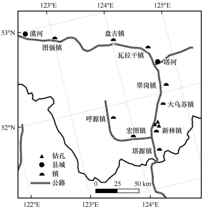
... 新林区地处大兴安岭东部, 伊勒呼里山的北坡, 地理坐标为东经123°41′ ~ 125°25′ E, 北纬51°20′ ~ 52°10′ N, 区内以低山为主, 中山较少, 平均海拔约600 m.这里地处寒温带, 属大陆性季风气候.冬季严寒而漫长, 夏季短促而炎热, 年平均气温为-3 ℃.年平均降水量为480 ~ 510 mm, 主要集中在6 - 9月份, 占全年总降水量的70%左右[23].区内植被属于大兴安岭山地寒温针叶林带, 是西伯利亚山地针叶林的南延部分.主要有兴安落叶松、 樟子松、 云杉、 白桦、 黑桦、 柴桦、 杜香、 忍冬、 塔头、 大叶樟、 鹿蹄草、 笃斯、 越橘、 莎草、 苔藓等[46].土壤主要为棕色针叶林土, 占总面积的90%以上, 分布在大兴安岭落叶松、 樟子松和次生白桦林下[47].从多年冻土分区上看, 该区属于岛状融区多年冻土区[48]. ...
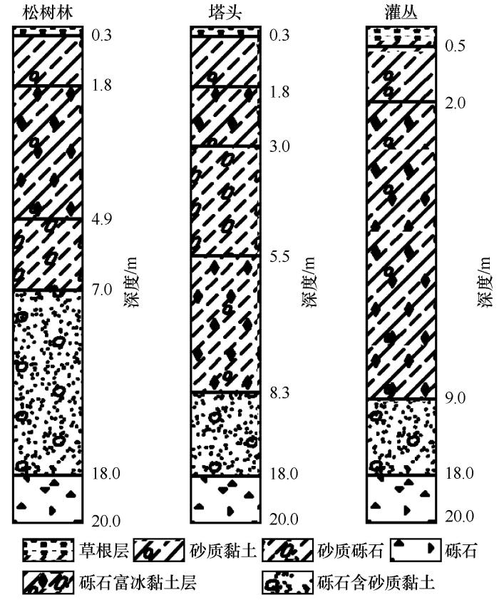
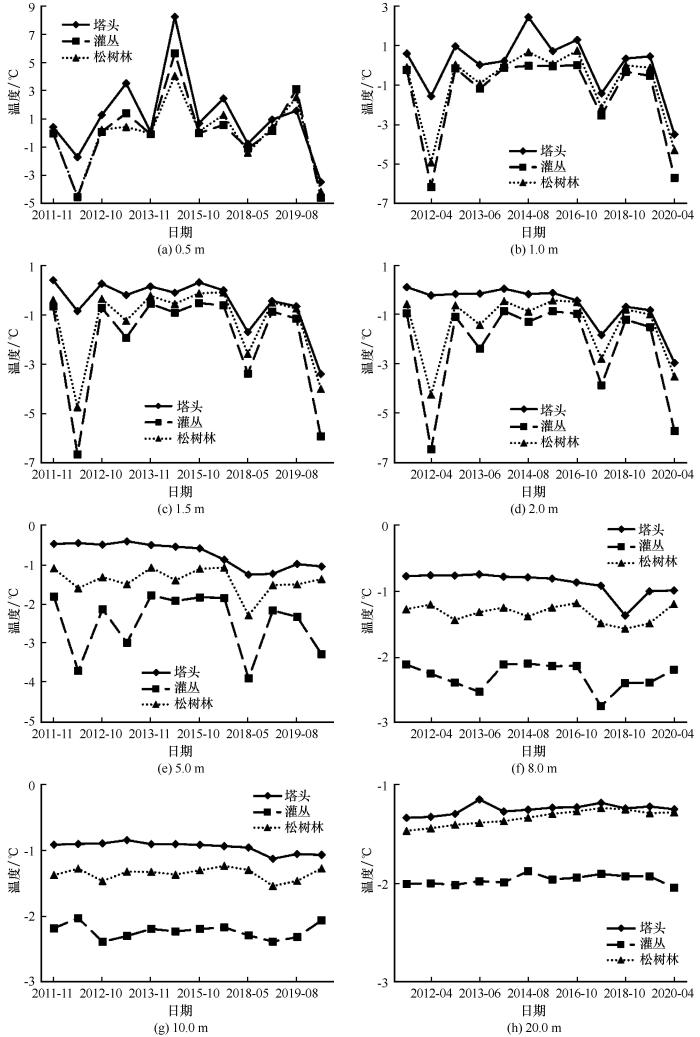
... 目前, 一般是根据钻孔测温结果来确认多年冻土层的厚度.从新林观测资料来看, 松树林-塔头-灌丛的年变化深度(即年较差等于零的深度)[23]基本为11 m, 年变化深度处年平均地温分别为-1.34、 -0.98、 -2.19 ℃, 年变化深度以下各个钻孔测得的地温梯度如表1. ...
... 从推算结果看, 塔头下的多年冻土最薄, 其次是松树林, 灌丛最厚.但无论是哪种推算方式, 新林林区的多年冻土厚度均不超过100 m, 这与原苏联科学院冻土研究所在与研究区相邻的研究结果相符[23].程氏推算和童氏推算均比地温梯度计算值小, 估计是前二者经验公式均由青藏高原高海拔多年冻土地区资料获得, 而青藏高原和西部地区地温梯度和地中热流比大兴安岭高造成的, 说明两个公式在大兴安岭地区不太适用.因此本文根据研究区钻孔自由地温梯度的推算, 松树林、 塔头、 灌丛的多年冻土厚度分别为63.8、 60.3、 84.6 m. ...
5
2000
... 冻土是地球五大圈层之一的冰冻圈系统的主要组成部分.它的存在、 分布以及水热状态对地气能水交换、 碳循环、 流域生态水文过程和工程建筑等产生重要的影响[1-8].在气候变化的背景下, 冻土温度和冻土分布的时空变化受到了广泛的关注[9-13], 它们既是寒区生态环境与碳循环研究[14-16]、 工程选址与设计的基础[17-21], 也是区域工程运行和资源综合规划管理的依据[22-23], 对我国生态文明建设与经济规划的实施具有重要的现实意义. ...
... 东北地区是我国唯一的高纬度多年冻土区, 也是我国第二大多年冻土区, 多年冻土面积近40万平方公里[23-25].兴安岭北部(牙克石以北)以高纬度冻土为主, 而其南部则以山地冻土为主, 从多年冻土南界往北, 冻土面积由10.5% ~ 20%, 增加到70% ~ 80%; 冻土温度由0 ~ 1.0 ℃下降到-1.0 ~ -2.0 ℃, 最低达-4.2 ℃; 冻土厚度由5 ~ 20 m增厚到60 ~ 70 m, 局部超过120 m; 多年冻土分布面积上的连续率也由零星岛状, 过渡为岛状融区到最北部呈大片分布[26-28].在兴安岭北部, 广袤无垠的森林和积雪是最具特色的下垫面, 对季节冻土和多年冻土的地温以及冻融作用有着十分重要的影响.在我国东北的兴安岭和俄罗斯的外贝加尔地区, 积雪、 植被、 水分、 地形和大气逆温等局地因素导致的温度位移十分显著, 因而形成与极地和高海拔冻土截然不同的兴安-贝加尔型多年冻土[29].此类冻土的形成、 发展和保存更多受制于局地因子, 例如盆地中部、 洼地的沼泽湿地的冻土比高处的山顶和中上部冻土更为发育(温度低、 厚度大, 热稳定性强)[29-31], 与其他环境因子相互作用复杂.有研究表明冻融过程对植物群落生态特征和物种多样性有显著的影响[32-33], 反过来林型不同也会制约多年冻土活动层和季节冻土的冻融速率[34-38].值得指出的是, 由于多年冻土特殊的物理属性, 使得冻土对地表植被类型变化和工程活动等的响应具有一定的滞后性[39-43], 冻土环境的破坏往往具有不可逆和灾难性后果[44-45]. ...
... 新林区地处大兴安岭东部, 伊勒呼里山的北坡, 地理坐标为东经123°41′ ~ 125°25′ E, 北纬51°20′ ~ 52°10′ N, 区内以低山为主, 中山较少, 平均海拔约600 m.这里地处寒温带, 属大陆性季风气候.冬季严寒而漫长, 夏季短促而炎热, 年平均气温为-3 ℃.年平均降水量为480 ~ 510 mm, 主要集中在6 - 9月份, 占全年总降水量的70%左右[23].区内植被属于大兴安岭山地寒温针叶林带, 是西伯利亚山地针叶林的南延部分.主要有兴安落叶松、 樟子松、 云杉、 白桦、 黑桦、 柴桦、 杜香、 忍冬、 塔头、 大叶樟、 鹿蹄草、 笃斯、 越橘、 莎草、 苔藓等[46].土壤主要为棕色针叶林土, 占总面积的90%以上, 分布在大兴安岭落叶松、 樟子松和次生白桦林下[47].从多年冻土分区上看, 该区属于岛状融区多年冻土区[48]. ...
... 目前, 一般是根据钻孔测温结果来确认多年冻土层的厚度.从新林观测资料来看, 松树林-塔头-灌丛的年变化深度(即年较差等于零的深度)[23]基本为11 m, 年变化深度处年平均地温分别为-1.34、 -0.98、 -2.19 ℃, 年变化深度以下各个钻孔测得的地温梯度如表1. ...
... 从推算结果看, 塔头下的多年冻土最薄, 其次是松树林, 灌丛最厚.但无论是哪种推算方式, 新林林区的多年冻土厚度均不超过100 m, 这与原苏联科学院冻土研究所在与研究区相邻的研究结果相符[23].程氏推算和童氏推算均比地温梯度计算值小, 估计是前二者经验公式均由青藏高原高海拔多年冻土地区资料获得, 而青藏高原和西部地区地温梯度和地中热流比大兴安岭高造成的, 说明两个公式在大兴安岭地区不太适用.因此本文根据研究区钻孔自由地温梯度的推算, 松树林、 塔头、 灌丛的多年冻土厚度分别为63.8、 60.3、 84.6 m. ...
Permafrost and climatic change in China
0
2000
1
2010
... 东北地区是我国唯一的高纬度多年冻土区, 也是我国第二大多年冻土区, 多年冻土面积近40万平方公里[23-25].兴安岭北部(牙克石以北)以高纬度冻土为主, 而其南部则以山地冻土为主, 从多年冻土南界往北, 冻土面积由10.5% ~ 20%, 增加到70% ~ 80%; 冻土温度由0 ~ 1.0 ℃下降到-1.0 ~ -2.0 ℃, 最低达-4.2 ℃; 冻土厚度由5 ~ 20 m增厚到60 ~ 70 m, 局部超过120 m; 多年冻土分布面积上的连续率也由零星岛状, 过渡为岛状融区到最北部呈大片分布[26-28].在兴安岭北部, 广袤无垠的森林和积雪是最具特色的下垫面, 对季节冻土和多年冻土的地温以及冻融作用有着十分重要的影响.在我国东北的兴安岭和俄罗斯的外贝加尔地区, 积雪、 植被、 水分、 地形和大气逆温等局地因素导致的温度位移十分显著, 因而形成与极地和高海拔冻土截然不同的兴安-贝加尔型多年冻土[29].此类冻土的形成、 发展和保存更多受制于局地因子, 例如盆地中部、 洼地的沼泽湿地的冻土比高处的山顶和中上部冻土更为发育(温度低、 厚度大, 热稳定性强)[29-31], 与其他环境因子相互作用复杂.有研究表明冻融过程对植物群落生态特征和物种多样性有显著的影响[32-33], 反过来林型不同也会制约多年冻土活动层和季节冻土的冻融速率[34-38].值得指出的是, 由于多年冻土特殊的物理属性, 使得冻土对地表植被类型变化和工程活动等的响应具有一定的滞后性[39-43], 冻土环境的破坏往往具有不可逆和灾难性后果[44-45]. ...
Major features of permafrost in China
1
1982
... 东北地区是我国唯一的高纬度多年冻土区, 也是我国第二大多年冻土区, 多年冻土面积近40万平方公里[23-25].兴安岭北部(牙克石以北)以高纬度冻土为主, 而其南部则以山地冻土为主, 从多年冻土南界往北, 冻土面积由10.5% ~ 20%, 增加到70% ~ 80%; 冻土温度由0 ~ 1.0 ℃下降到-1.0 ~ -2.0 ℃, 最低达-4.2 ℃; 冻土厚度由5 ~ 20 m增厚到60 ~ 70 m, 局部超过120 m; 多年冻土分布面积上的连续率也由零星岛状, 过渡为岛状融区到最北部呈大片分布[26-28].在兴安岭北部, 广袤无垠的森林和积雪是最具特色的下垫面, 对季节冻土和多年冻土的地温以及冻融作用有着十分重要的影响.在我国东北的兴安岭和俄罗斯的外贝加尔地区, 积雪、 植被、 水分、 地形和大气逆温等局地因素导致的温度位移十分显著, 因而形成与极地和高海拔冻土截然不同的兴安-贝加尔型多年冻土[29].此类冻土的形成、 发展和保存更多受制于局地因子, 例如盆地中部、 洼地的沼泽湿地的冻土比高处的山顶和中上部冻土更为发育(温度低、 厚度大, 热稳定性强)[29-31], 与其他环境因子相互作用复杂.有研究表明冻融过程对植物群落生态特征和物种多样性有显著的影响[32-33], 反过来林型不同也会制约多年冻土活动层和季节冻土的冻融速率[34-38].值得指出的是, 由于多年冻土特殊的物理属性, 使得冻土对地表植被类型变化和工程活动等的响应具有一定的滞后性[39-43], 冻土环境的破坏往往具有不可逆和灾难性后果[44-45]. ...
我国多年冻土的主要特征
1
1982
... 东北地区是我国唯一的高纬度多年冻土区, 也是我国第二大多年冻土区, 多年冻土面积近40万平方公里[23-25].兴安岭北部(牙克石以北)以高纬度冻土为主, 而其南部则以山地冻土为主, 从多年冻土南界往北, 冻土面积由10.5% ~ 20%, 增加到70% ~ 80%; 冻土温度由0 ~ 1.0 ℃下降到-1.0 ~ -2.0 ℃, 最低达-4.2 ℃; 冻土厚度由5 ~ 20 m增厚到60 ~ 70 m, 局部超过120 m; 多年冻土分布面积上的连续率也由零星岛状, 过渡为岛状融区到最北部呈大片分布[26-28].在兴安岭北部, 广袤无垠的森林和积雪是最具特色的下垫面, 对季节冻土和多年冻土的地温以及冻融作用有着十分重要的影响.在我国东北的兴安岭和俄罗斯的外贝加尔地区, 积雪、 植被、 水分、 地形和大气逆温等局地因素导致的温度位移十分显著, 因而形成与极地和高海拔冻土截然不同的兴安-贝加尔型多年冻土[29].此类冻土的形成、 发展和保存更多受制于局地因子, 例如盆地中部、 洼地的沼泽湿地的冻土比高处的山顶和中上部冻土更为发育(温度低、 厚度大, 热稳定性强)[29-31], 与其他环境因子相互作用复杂.有研究表明冻融过程对植物群落生态特征和物种多样性有显著的影响[32-33], 反过来林型不同也会制约多年冻土活动层和季节冻土的冻融速率[34-38].值得指出的是, 由于多年冻土特殊的物理属性, 使得冻土对地表植被类型变化和工程活动等的响应具有一定的滞后性[39-43], 冻土环境的破坏往往具有不可逆和灾难性后果[44-45]. ...
Geographical southern limit of permafrost in northeastern China
0
1993
Temperatures and distribution of permafrost in northeastern China under a warming climate
1
1996
... 东北地区是我国唯一的高纬度多年冻土区, 也是我国第二大多年冻土区, 多年冻土面积近40万平方公里[23-25].兴安岭北部(牙克石以北)以高纬度冻土为主, 而其南部则以山地冻土为主, 从多年冻土南界往北, 冻土面积由10.5% ~ 20%, 增加到70% ~ 80%; 冻土温度由0 ~ 1.0 ℃下降到-1.0 ~ -2.0 ℃, 最低达-4.2 ℃; 冻土厚度由5 ~ 20 m增厚到60 ~ 70 m, 局部超过120 m; 多年冻土分布面积上的连续率也由零星岛状, 过渡为岛状融区到最北部呈大片分布[26-28].在兴安岭北部, 广袤无垠的森林和积雪是最具特色的下垫面, 对季节冻土和多年冻土的地温以及冻融作用有着十分重要的影响.在我国东北的兴安岭和俄罗斯的外贝加尔地区, 积雪、 植被、 水分、 地形和大气逆温等局地因素导致的温度位移十分显著, 因而形成与极地和高海拔冻土截然不同的兴安-贝加尔型多年冻土[29].此类冻土的形成、 发展和保存更多受制于局地因子, 例如盆地中部、 洼地的沼泽湿地的冻土比高处的山顶和中上部冻土更为发育(温度低、 厚度大, 热稳定性强)[29-31], 与其他环境因子相互作用复杂.有研究表明冻融过程对植物群落生态特征和物种多样性有显著的影响[32-33], 反过来林型不同也会制约多年冻土活动层和季节冻土的冻融速率[34-38].值得指出的是, 由于多年冻土特殊的物理属性, 使得冻土对地表植被类型变化和工程活动等的响应具有一定的滞后性[39-43], 冻土环境的破坏往往具有不可逆和灾难性后果[44-45]. ...
我国东北部冻土温度和分布与气候变暖
1
1996
... 东北地区是我国唯一的高纬度多年冻土区, 也是我国第二大多年冻土区, 多年冻土面积近40万平方公里[23-25].兴安岭北部(牙克石以北)以高纬度冻土为主, 而其南部则以山地冻土为主, 从多年冻土南界往北, 冻土面积由10.5% ~ 20%, 增加到70% ~ 80%; 冻土温度由0 ~ 1.0 ℃下降到-1.0 ~ -2.0 ℃, 最低达-4.2 ℃; 冻土厚度由5 ~ 20 m增厚到60 ~ 70 m, 局部超过120 m; 多年冻土分布面积上的连续率也由零星岛状, 过渡为岛状融区到最北部呈大片分布[26-28].在兴安岭北部, 广袤无垠的森林和积雪是最具特色的下垫面, 对季节冻土和多年冻土的地温以及冻融作用有着十分重要的影响.在我国东北的兴安岭和俄罗斯的外贝加尔地区, 积雪、 植被、 水分、 地形和大气逆温等局地因素导致的温度位移十分显著, 因而形成与极地和高海拔冻土截然不同的兴安-贝加尔型多年冻土[29].此类冻土的形成、 发展和保存更多受制于局地因子, 例如盆地中部、 洼地的沼泽湿地的冻土比高处的山顶和中上部冻土更为发育(温度低、 厚度大, 热稳定性强)[29-31], 与其他环境因子相互作用复杂.有研究表明冻融过程对植物群落生态特征和物种多样性有显著的影响[32-33], 反过来林型不同也会制约多年冻土活动层和季节冻土的冻融速率[34-38].值得指出的是, 由于多年冻土特殊的物理属性, 使得冻土对地表植被类型变化和工程活动等的响应具有一定的滞后性[39-43], 冻土环境的破坏往往具有不可逆和灾难性后果[44-45]. ...
2
1990
... 东北地区是我国唯一的高纬度多年冻土区, 也是我国第二大多年冻土区, 多年冻土面积近40万平方公里[23-25].兴安岭北部(牙克石以北)以高纬度冻土为主, 而其南部则以山地冻土为主, 从多年冻土南界往北, 冻土面积由10.5% ~ 20%, 增加到70% ~ 80%; 冻土温度由0 ~ 1.0 ℃下降到-1.0 ~ -2.0 ℃, 最低达-4.2 ℃; 冻土厚度由5 ~ 20 m增厚到60 ~ 70 m, 局部超过120 m; 多年冻土分布面积上的连续率也由零星岛状, 过渡为岛状融区到最北部呈大片分布[26-28].在兴安岭北部, 广袤无垠的森林和积雪是最具特色的下垫面, 对季节冻土和多年冻土的地温以及冻融作用有着十分重要的影响.在我国东北的兴安岭和俄罗斯的外贝加尔地区, 积雪、 植被、 水分、 地形和大气逆温等局地因素导致的温度位移十分显著, 因而形成与极地和高海拔冻土截然不同的兴安-贝加尔型多年冻土[29].此类冻土的形成、 发展和保存更多受制于局地因子, 例如盆地中部、 洼地的沼泽湿地的冻土比高处的山顶和中上部冻土更为发育(温度低、 厚度大, 热稳定性强)[29-31], 与其他环境因子相互作用复杂.有研究表明冻融过程对植物群落生态特征和物种多样性有显著的影响[32-33], 反过来林型不同也会制约多年冻土活动层和季节冻土的冻融速率[34-38].值得指出的是, 由于多年冻土特殊的物理属性, 使得冻土对地表植被类型变化和工程活动等的响应具有一定的滞后性[39-43], 冻土环境的破坏往往具有不可逆和灾难性后果[44-45]. ...
... [29-31], 与其他环境因子相互作用复杂.有研究表明冻融过程对植物群落生态特征和物种多样性有显著的影响[32-33], 反过来林型不同也会制约多年冻土活动层和季节冻土的冻融速率[34-38].值得指出的是, 由于多年冻土特殊的物理属性, 使得冻土对地表植被类型变化和工程活动等的响应具有一定的滞后性[39-43], 冻土环境的破坏往往具有不可逆和灾难性后果[44-45]. ...
Advances in permafrost and cold regions environments studies in the Da Hinggan Mountains, Northeastern China
0
2008
中国东北大兴安岭多年冻土与寒区环境考察和研究进展
0
2008
Features of permafrost degradation in Hinggan Mountains, Northeastern China
1
2009
... 东北地区是我国唯一的高纬度多年冻土区, 也是我国第二大多年冻土区, 多年冻土面积近40万平方公里[23-25].兴安岭北部(牙克石以北)以高纬度冻土为主, 而其南部则以山地冻土为主, 从多年冻土南界往北, 冻土面积由10.5% ~ 20%, 增加到70% ~ 80%; 冻土温度由0 ~ 1.0 ℃下降到-1.0 ~ -2.0 ℃, 最低达-4.2 ℃; 冻土厚度由5 ~ 20 m增厚到60 ~ 70 m, 局部超过120 m; 多年冻土分布面积上的连续率也由零星岛状, 过渡为岛状融区到最北部呈大片分布[26-28].在兴安岭北部, 广袤无垠的森林和积雪是最具特色的下垫面, 对季节冻土和多年冻土的地温以及冻融作用有着十分重要的影响.在我国东北的兴安岭和俄罗斯的外贝加尔地区, 积雪、 植被、 水分、 地形和大气逆温等局地因素导致的温度位移十分显著, 因而形成与极地和高海拔冻土截然不同的兴安-贝加尔型多年冻土[29].此类冻土的形成、 发展和保存更多受制于局地因子, 例如盆地中部、 洼地的沼泽湿地的冻土比高处的山顶和中上部冻土更为发育(温度低、 厚度大, 热稳定性强)[29-31], 与其他环境因子相互作用复杂.有研究表明冻融过程对植物群落生态特征和物种多样性有显著的影响[32-33], 反过来林型不同也会制约多年冻土活动层和季节冻土的冻融速率[34-38].值得指出的是, 由于多年冻土特殊的物理属性, 使得冻土对地表植被类型变化和工程活动等的响应具有一定的滞后性[39-43], 冻土环境的破坏往往具有不可逆和灾难性后果[44-45]. ...
兴安岭多年冻土退化特征
1
2009
... 东北地区是我国唯一的高纬度多年冻土区, 也是我国第二大多年冻土区, 多年冻土面积近40万平方公里[23-25].兴安岭北部(牙克石以北)以高纬度冻土为主, 而其南部则以山地冻土为主, 从多年冻土南界往北, 冻土面积由10.5% ~ 20%, 增加到70% ~ 80%; 冻土温度由0 ~ 1.0 ℃下降到-1.0 ~ -2.0 ℃, 最低达-4.2 ℃; 冻土厚度由5 ~ 20 m增厚到60 ~ 70 m, 局部超过120 m; 多年冻土分布面积上的连续率也由零星岛状, 过渡为岛状融区到最北部呈大片分布[26-28].在兴安岭北部, 广袤无垠的森林和积雪是最具特色的下垫面, 对季节冻土和多年冻土的地温以及冻融作用有着十分重要的影响.在我国东北的兴安岭和俄罗斯的外贝加尔地区, 积雪、 植被、 水分、 地形和大气逆温等局地因素导致的温度位移十分显著, 因而形成与极地和高海拔冻土截然不同的兴安-贝加尔型多年冻土[29].此类冻土的形成、 发展和保存更多受制于局地因子, 例如盆地中部、 洼地的沼泽湿地的冻土比高处的山顶和中上部冻土更为发育(温度低、 厚度大, 热稳定性强)[29-31], 与其他环境因子相互作用复杂.有研究表明冻融过程对植物群落生态特征和物种多样性有显著的影响[32-33], 反过来林型不同也会制约多年冻土活动层和季节冻土的冻融速率[34-38].值得指出的是, 由于多年冻土特殊的物理属性, 使得冻土对地表植被类型变化和工程活动等的响应具有一定的滞后性[39-43], 冻土环境的破坏往往具有不可逆和灾难性后果[44-45]. ...
Ecological characteristics of vegetation and their responses to permafrost degradation in the north slope of Great Khingan Mountain valley of northeast China
1
2017
... 东北地区是我国唯一的高纬度多年冻土区, 也是我国第二大多年冻土区, 多年冻土面积近40万平方公里[23-25].兴安岭北部(牙克石以北)以高纬度冻土为主, 而其南部则以山地冻土为主, 从多年冻土南界往北, 冻土面积由10.5% ~ 20%, 增加到70% ~ 80%; 冻土温度由0 ~ 1.0 ℃下降到-1.0 ~ -2.0 ℃, 最低达-4.2 ℃; 冻土厚度由5 ~ 20 m增厚到60 ~ 70 m, 局部超过120 m; 多年冻土分布面积上的连续率也由零星岛状, 过渡为岛状融区到最北部呈大片分布[26-28].在兴安岭北部, 广袤无垠的森林和积雪是最具特色的下垫面, 对季节冻土和多年冻土的地温以及冻融作用有着十分重要的影响.在我国东北的兴安岭和俄罗斯的外贝加尔地区, 积雪、 植被、 水分、 地形和大气逆温等局地因素导致的温度位移十分显著, 因而形成与极地和高海拔冻土截然不同的兴安-贝加尔型多年冻土[29].此类冻土的形成、 发展和保存更多受制于局地因子, 例如盆地中部、 洼地的沼泽湿地的冻土比高处的山顶和中上部冻土更为发育(温度低、 厚度大, 热稳定性强)[29-31], 与其他环境因子相互作用复杂.有研究表明冻融过程对植物群落生态特征和物种多样性有显著的影响[32-33], 反过来林型不同也会制约多年冻土活动层和季节冻土的冻融速率[34-38].值得指出的是, 由于多年冻土特殊的物理属性, 使得冻土对地表植被类型变化和工程活动等的响应具有一定的滞后性[39-43], 冻土环境的破坏往往具有不可逆和灾难性后果[44-45]. ...
大兴安岭北坡多年冻土区植物生态特征及其对冻土退化的响应
1
2017
... 东北地区是我国唯一的高纬度多年冻土区, 也是我国第二大多年冻土区, 多年冻土面积近40万平方公里[23-25].兴安岭北部(牙克石以北)以高纬度冻土为主, 而其南部则以山地冻土为主, 从多年冻土南界往北, 冻土面积由10.5% ~ 20%, 增加到70% ~ 80%; 冻土温度由0 ~ 1.0 ℃下降到-1.0 ~ -2.0 ℃, 最低达-4.2 ℃; 冻土厚度由5 ~ 20 m增厚到60 ~ 70 m, 局部超过120 m; 多年冻土分布面积上的连续率也由零星岛状, 过渡为岛状融区到最北部呈大片分布[26-28].在兴安岭北部, 广袤无垠的森林和积雪是最具特色的下垫面, 对季节冻土和多年冻土的地温以及冻融作用有着十分重要的影响.在我国东北的兴安岭和俄罗斯的外贝加尔地区, 积雪、 植被、 水分、 地形和大气逆温等局地因素导致的温度位移十分显著, 因而形成与极地和高海拔冻土截然不同的兴安-贝加尔型多年冻土[29].此类冻土的形成、 发展和保存更多受制于局地因子, 例如盆地中部、 洼地的沼泽湿地的冻土比高处的山顶和中上部冻土更为发育(温度低、 厚度大, 热稳定性强)[29-31], 与其他环境因子相互作用复杂.有研究表明冻融过程对植物群落生态特征和物种多样性有显著的影响[32-33], 反过来林型不同也会制约多年冻土活动层和季节冻土的冻融速率[34-38].值得指出的是, 由于多年冻土特殊的物理属性, 使得冻土对地表植被类型变化和工程活动等的响应具有一定的滞后性[39-43], 冻土环境的破坏往往具有不可逆和灾难性后果[44-45]. ...
Classification of plant communities and species diversity responses to changes in permafrost depths of the north slope of the Great Khingan Mountain valley of Northeast China
1
2016
... 东北地区是我国唯一的高纬度多年冻土区, 也是我国第二大多年冻土区, 多年冻土面积近40万平方公里[23-25].兴安岭北部(牙克石以北)以高纬度冻土为主, 而其南部则以山地冻土为主, 从多年冻土南界往北, 冻土面积由10.5% ~ 20%, 增加到70% ~ 80%; 冻土温度由0 ~ 1.0 ℃下降到-1.0 ~ -2.0 ℃, 最低达-4.2 ℃; 冻土厚度由5 ~ 20 m增厚到60 ~ 70 m, 局部超过120 m; 多年冻土分布面积上的连续率也由零星岛状, 过渡为岛状融区到最北部呈大片分布[26-28].在兴安岭北部, 广袤无垠的森林和积雪是最具特色的下垫面, 对季节冻土和多年冻土的地温以及冻融作用有着十分重要的影响.在我国东北的兴安岭和俄罗斯的外贝加尔地区, 积雪、 植被、 水分、 地形和大气逆温等局地因素导致的温度位移十分显著, 因而形成与极地和高海拔冻土截然不同的兴安-贝加尔型多年冻土[29].此类冻土的形成、 发展和保存更多受制于局地因子, 例如盆地中部、 洼地的沼泽湿地的冻土比高处的山顶和中上部冻土更为发育(温度低、 厚度大, 热稳定性强)[29-31], 与其他环境因子相互作用复杂.有研究表明冻融过程对植物群落生态特征和物种多样性有显著的影响[32-33], 反过来林型不同也会制约多年冻土活动层和季节冻土的冻融速率[34-38].值得指出的是, 由于多年冻土特殊的物理属性, 使得冻土对地表植被类型变化和工程活动等的响应具有一定的滞后性[39-43], 冻土环境的破坏往往具有不可逆和灾难性后果[44-45]. ...
大兴安岭北坡多年冻土区植物群落分类及其物种多样性对冻土融深变化的响应
1
2016
... 东北地区是我国唯一的高纬度多年冻土区, 也是我国第二大多年冻土区, 多年冻土面积近40万平方公里[23-25].兴安岭北部(牙克石以北)以高纬度冻土为主, 而其南部则以山地冻土为主, 从多年冻土南界往北, 冻土面积由10.5% ~ 20%, 增加到70% ~ 80%; 冻土温度由0 ~ 1.0 ℃下降到-1.0 ~ -2.0 ℃, 最低达-4.2 ℃; 冻土厚度由5 ~ 20 m增厚到60 ~ 70 m, 局部超过120 m; 多年冻土分布面积上的连续率也由零星岛状, 过渡为岛状融区到最北部呈大片分布[26-28].在兴安岭北部, 广袤无垠的森林和积雪是最具特色的下垫面, 对季节冻土和多年冻土的地温以及冻融作用有着十分重要的影响.在我国东北的兴安岭和俄罗斯的外贝加尔地区, 积雪、 植被、 水分、 地形和大气逆温等局地因素导致的温度位移十分显著, 因而形成与极地和高海拔冻土截然不同的兴安-贝加尔型多年冻土[29].此类冻土的形成、 发展和保存更多受制于局地因子, 例如盆地中部、 洼地的沼泽湿地的冻土比高处的山顶和中上部冻土更为发育(温度低、 厚度大, 热稳定性强)[29-31], 与其他环境因子相互作用复杂.有研究表明冻融过程对植物群落生态特征和物种多样性有显著的影响[32-33], 反过来林型不同也会制约多年冻土活动层和季节冻土的冻融速率[34-38].值得指出的是, 由于多年冻土特殊的物理属性, 使得冻土对地表植被类型变化和工程活动等的响应具有一定的滞后性[39-43], 冻土环境的破坏往往具有不可逆和灾难性后果[44-45]. ...
Influence of vegetation on frozen ground temperatures the forested area in the Da Xing'anling Mountains, Northeastern China
2
2011
... 东北地区是我国唯一的高纬度多年冻土区, 也是我国第二大多年冻土区, 多年冻土面积近40万平方公里[23-25].兴安岭北部(牙克石以北)以高纬度冻土为主, 而其南部则以山地冻土为主, 从多年冻土南界往北, 冻土面积由10.5% ~ 20%, 增加到70% ~ 80%; 冻土温度由0 ~ 1.0 ℃下降到-1.0 ~ -2.0 ℃, 最低达-4.2 ℃; 冻土厚度由5 ~ 20 m增厚到60 ~ 70 m, 局部超过120 m; 多年冻土分布面积上的连续率也由零星岛状, 过渡为岛状融区到最北部呈大片分布[26-28].在兴安岭北部, 广袤无垠的森林和积雪是最具特色的下垫面, 对季节冻土和多年冻土的地温以及冻融作用有着十分重要的影响.在我国东北的兴安岭和俄罗斯的外贝加尔地区, 积雪、 植被、 水分、 地形和大气逆温等局地因素导致的温度位移十分显著, 因而形成与极地和高海拔冻土截然不同的兴安-贝加尔型多年冻土[29].此类冻土的形成、 发展和保存更多受制于局地因子, 例如盆地中部、 洼地的沼泽湿地的冻土比高处的山顶和中上部冻土更为发育(温度低、 厚度大, 热稳定性强)[29-31], 与其他环境因子相互作用复杂.有研究表明冻融过程对植物群落生态特征和物种多样性有显著的影响[32-33], 反过来林型不同也会制约多年冻土活动层和季节冻土的冻融速率[34-38].值得指出的是, 由于多年冻土特殊的物理属性, 使得冻土对地表植被类型变化和工程活动等的响应具有一定的滞后性[39-43], 冻土环境的破坏往往具有不可逆和灾难性后果[44-45]. ...
... 这与大兴安岭西坡根河生态站的观测情况正好相反[34], 主要是因为生态站属于原始林, 未有人类和动物的任何破坏, 生态环境及其湿地功能完好, 塔头有良好的吸水保水能力, 避免地面升温降温幅度过高.而位于新林研究区内的塔头由于放牧以及人类活动(如中俄输油管线工程施工、 加漠公路从旁边穿过)影响, 地表植被破坏, 土壤孔隙度减小, 密实度增大[56-57], 地表积水和蒸发增大, 导热能力增加[58], 地温偏高.这里的松树林冠层大, 能够有效阻挡到达地面的直接太阳辐射, 并且形成阴影降低地面温度, 使得松树林地温较低.灌丛密度大, 同样可以有效阻挡太阳辐射, 又有大量的原始塔头草覆被地表, 吸水保水能力增强, 灌丛钻孔岩芯富冰层厚达9 m, 这样既能阻碍夏季地温升高, 又使地层冬季散失较多热量, 因此尽管表层温度略高于松树林, 其他深度处的地温还是很低. ...
大兴安岭林区不同植被对冻土地温的影响
2
2011
... 东北地区是我国唯一的高纬度多年冻土区, 也是我国第二大多年冻土区, 多年冻土面积近40万平方公里[23-25].兴安岭北部(牙克石以北)以高纬度冻土为主, 而其南部则以山地冻土为主, 从多年冻土南界往北, 冻土面积由10.5% ~ 20%, 增加到70% ~ 80%; 冻土温度由0 ~ 1.0 ℃下降到-1.0 ~ -2.0 ℃, 最低达-4.2 ℃; 冻土厚度由5 ~ 20 m增厚到60 ~ 70 m, 局部超过120 m; 多年冻土分布面积上的连续率也由零星岛状, 过渡为岛状融区到最北部呈大片分布[26-28].在兴安岭北部, 广袤无垠的森林和积雪是最具特色的下垫面, 对季节冻土和多年冻土的地温以及冻融作用有着十分重要的影响.在我国东北的兴安岭和俄罗斯的外贝加尔地区, 积雪、 植被、 水分、 地形和大气逆温等局地因素导致的温度位移十分显著, 因而形成与极地和高海拔冻土截然不同的兴安-贝加尔型多年冻土[29].此类冻土的形成、 发展和保存更多受制于局地因子, 例如盆地中部、 洼地的沼泽湿地的冻土比高处的山顶和中上部冻土更为发育(温度低、 厚度大, 热稳定性强)[29-31], 与其他环境因子相互作用复杂.有研究表明冻融过程对植物群落生态特征和物种多样性有显著的影响[32-33], 反过来林型不同也会制约多年冻土活动层和季节冻土的冻融速率[34-38].值得指出的是, 由于多年冻土特殊的物理属性, 使得冻土对地表植被类型变化和工程活动等的响应具有一定的滞后性[39-43], 冻土环境的破坏往往具有不可逆和灾难性后果[44-45]. ...
... 这与大兴安岭西坡根河生态站的观测情况正好相反[34], 主要是因为生态站属于原始林, 未有人类和动物的任何破坏, 生态环境及其湿地功能完好, 塔头有良好的吸水保水能力, 避免地面升温降温幅度过高.而位于新林研究区内的塔头由于放牧以及人类活动(如中俄输油管线工程施工、 加漠公路从旁边穿过)影响, 地表植被破坏, 土壤孔隙度减小, 密实度增大[56-57], 地表积水和蒸发增大, 导热能力增加[58], 地温偏高.这里的松树林冠层大, 能够有效阻挡到达地面的直接太阳辐射, 并且形成阴影降低地面温度, 使得松树林地温较低.灌丛密度大, 同样可以有效阻挡太阳辐射, 又有大量的原始塔头草覆被地表, 吸水保水能力增强, 灌丛钻孔岩芯富冰层厚达9 m, 这样既能阻碍夏季地温升高, 又使地层冬季散失较多热量, 因此尽管表层温度略高于松树林, 其他深度处的地温还是很低. ...
The characteristics and changing tendency of permafrost in the source region of Datong River, Qilian Mountains
0
2015
Spatial and temporal variation characteristics on the onset dates of freezing and thawing of active layer and its influence factors in permafrost regions along the Qinghai-Tibet Highway
0
2018
青藏公路沿线多年冻土区活动层起始冻融时间的时空变化特征和影响因素
0
2018
Effect of freezing and thawing cycles on soil microbial activity and organic carbon density in forest swamp wetland with various drainage afforestation years
0
2017
冻融交替对不同年代排水造林湿地土壤微生物活性及有机碳密度的影响
0
2017
China
1
2008
... 东北地区是我国唯一的高纬度多年冻土区, 也是我国第二大多年冻土区, 多年冻土面积近40万平方公里[23-25].兴安岭北部(牙克石以北)以高纬度冻土为主, 而其南部则以山地冻土为主, 从多年冻土南界往北, 冻土面积由10.5% ~ 20%, 增加到70% ~ 80%; 冻土温度由0 ~ 1.0 ℃下降到-1.0 ~ -2.0 ℃, 最低达-4.2 ℃; 冻土厚度由5 ~ 20 m增厚到60 ~ 70 m, 局部超过120 m; 多年冻土分布面积上的连续率也由零星岛状, 过渡为岛状融区到最北部呈大片分布[26-28].在兴安岭北部, 广袤无垠的森林和积雪是最具特色的下垫面, 对季节冻土和多年冻土的地温以及冻融作用有着十分重要的影响.在我国东北的兴安岭和俄罗斯的外贝加尔地区, 积雪、 植被、 水分、 地形和大气逆温等局地因素导致的温度位移十分显著, 因而形成与极地和高海拔冻土截然不同的兴安-贝加尔型多年冻土[29].此类冻土的形成、 发展和保存更多受制于局地因子, 例如盆地中部、 洼地的沼泽湿地的冻土比高处的山顶和中上部冻土更为发育(温度低、 厚度大, 热稳定性强)[29-31], 与其他环境因子相互作用复杂.有研究表明冻融过程对植物群落生态特征和物种多样性有显著的影响[32-33], 反过来林型不同也会制约多年冻土活动层和季节冻土的冻融速率[34-38].值得指出的是, 由于多年冻土特殊的物理属性, 使得冻土对地表植被类型变化和工程活动等的响应具有一定的滞后性[39-43], 冻土环境的破坏往往具有不可逆和灾难性后果[44-45]. ...
黄河源区不同植被类型覆盖下季节冻土冻融过程中的土壤温湿空间变化
1
2008
... 东北地区是我国唯一的高纬度多年冻土区, 也是我国第二大多年冻土区, 多年冻土面积近40万平方公里[23-25].兴安岭北部(牙克石以北)以高纬度冻土为主, 而其南部则以山地冻土为主, 从多年冻土南界往北, 冻土面积由10.5% ~ 20%, 增加到70% ~ 80%; 冻土温度由0 ~ 1.0 ℃下降到-1.0 ~ -2.0 ℃, 最低达-4.2 ℃; 冻土厚度由5 ~ 20 m增厚到60 ~ 70 m, 局部超过120 m; 多年冻土分布面积上的连续率也由零星岛状, 过渡为岛状融区到最北部呈大片分布[26-28].在兴安岭北部, 广袤无垠的森林和积雪是最具特色的下垫面, 对季节冻土和多年冻土的地温以及冻融作用有着十分重要的影响.在我国东北的兴安岭和俄罗斯的外贝加尔地区, 积雪、 植被、 水分、 地形和大气逆温等局地因素导致的温度位移十分显著, 因而形成与极地和高海拔冻土截然不同的兴安-贝加尔型多年冻土[29].此类冻土的形成、 发展和保存更多受制于局地因子, 例如盆地中部、 洼地的沼泽湿地的冻土比高处的山顶和中上部冻土更为发育(温度低、 厚度大, 热稳定性强)[29-31], 与其他环境因子相互作用复杂.有研究表明冻融过程对植物群落生态特征和物种多样性有显著的影响[32-33], 反过来林型不同也会制约多年冻土活动层和季节冻土的冻融速率[34-38].值得指出的是, 由于多年冻土特殊的物理属性, 使得冻土对地表植被类型变化和工程活动等的响应具有一定的滞后性[39-43], 冻土环境的破坏往往具有不可逆和灾难性后果[44-45]. ...
Study of groundwater in permafrost regions of China: status and process
1
2019
... 东北地区是我国唯一的高纬度多年冻土区, 也是我国第二大多年冻土区, 多年冻土面积近40万平方公里[23-25].兴安岭北部(牙克石以北)以高纬度冻土为主, 而其南部则以山地冻土为主, 从多年冻土南界往北, 冻土面积由10.5% ~ 20%, 增加到70% ~ 80%; 冻土温度由0 ~ 1.0 ℃下降到-1.0 ~ -2.0 ℃, 最低达-4.2 ℃; 冻土厚度由5 ~ 20 m增厚到60 ~ 70 m, 局部超过120 m; 多年冻土分布面积上的连续率也由零星岛状, 过渡为岛状融区到最北部呈大片分布[26-28].在兴安岭北部, 广袤无垠的森林和积雪是最具特色的下垫面, 对季节冻土和多年冻土的地温以及冻融作用有着十分重要的影响.在我国东北的兴安岭和俄罗斯的外贝加尔地区, 积雪、 植被、 水分、 地形和大气逆温等局地因素导致的温度位移十分显著, 因而形成与极地和高海拔冻土截然不同的兴安-贝加尔型多年冻土[29].此类冻土的形成、 发展和保存更多受制于局地因子, 例如盆地中部、 洼地的沼泽湿地的冻土比高处的山顶和中上部冻土更为发育(温度低、 厚度大, 热稳定性强)[29-31], 与其他环境因子相互作用复杂.有研究表明冻融过程对植物群落生态特征和物种多样性有显著的影响[32-33], 反过来林型不同也会制约多年冻土活动层和季节冻土的冻融速率[34-38].值得指出的是, 由于多年冻土特殊的物理属性, 使得冻土对地表植被类型变化和工程活动等的响应具有一定的滞后性[39-43], 冻土环境的破坏往往具有不可逆和灾难性后果[44-45]. ...
中国冻土地下水研究现状与进展综述
1
2019
... 东北地区是我国唯一的高纬度多年冻土区, 也是我国第二大多年冻土区, 多年冻土面积近40万平方公里[23-25].兴安岭北部(牙克石以北)以高纬度冻土为主, 而其南部则以山地冻土为主, 从多年冻土南界往北, 冻土面积由10.5% ~ 20%, 增加到70% ~ 80%; 冻土温度由0 ~ 1.0 ℃下降到-1.0 ~ -2.0 ℃, 最低达-4.2 ℃; 冻土厚度由5 ~ 20 m增厚到60 ~ 70 m, 局部超过120 m; 多年冻土分布面积上的连续率也由零星岛状, 过渡为岛状融区到最北部呈大片分布[26-28].在兴安岭北部, 广袤无垠的森林和积雪是最具特色的下垫面, 对季节冻土和多年冻土的地温以及冻融作用有着十分重要的影响.在我国东北的兴安岭和俄罗斯的外贝加尔地区, 积雪、 植被、 水分、 地形和大气逆温等局地因素导致的温度位移十分显著, 因而形成与极地和高海拔冻土截然不同的兴安-贝加尔型多年冻土[29].此类冻土的形成、 发展和保存更多受制于局地因子, 例如盆地中部、 洼地的沼泽湿地的冻土比高处的山顶和中上部冻土更为发育(温度低、 厚度大, 热稳定性强)[29-31], 与其他环境因子相互作用复杂.有研究表明冻融过程对植物群落生态特征和物种多样性有显著的影响[32-33], 反过来林型不同也会制约多年冻土活动层和季节冻土的冻融速率[34-38].值得指出的是, 由于多年冻土特殊的物理属性, 使得冻土对地表植被类型变化和工程活动等的响应具有一定的滞后性[39-43], 冻土环境的破坏往往具有不可逆和灾难性后果[44-45]. ...
Permafrost degradation in Northeast China and its environmental effects: present situation and prospect
0
2018
东北多年冻土退化及环境效应研究现状与展望
0
2018
Prediction of permafrost changes in Northeastern China under changing climate
0
2011
气候变化条件下东北地区多年冻土变化预测
0
2011
Introduction to special section: permafrost and seasonally frozen ground under a changing climate
0
2007
Recent changes of permafrost and cold regions environments in the northern part of Northeastern China
1
2009
... 东北地区是我国唯一的高纬度多年冻土区, 也是我国第二大多年冻土区, 多年冻土面积近40万平方公里[23-25].兴安岭北部(牙克石以北)以高纬度冻土为主, 而其南部则以山地冻土为主, 从多年冻土南界往北, 冻土面积由10.5% ~ 20%, 增加到70% ~ 80%; 冻土温度由0 ~ 1.0 ℃下降到-1.0 ~ -2.0 ℃, 最低达-4.2 ℃; 冻土厚度由5 ~ 20 m增厚到60 ~ 70 m, 局部超过120 m; 多年冻土分布面积上的连续率也由零星岛状, 过渡为岛状融区到最北部呈大片分布[26-28].在兴安岭北部, 广袤无垠的森林和积雪是最具特色的下垫面, 对季节冻土和多年冻土的地温以及冻融作用有着十分重要的影响.在我国东北的兴安岭和俄罗斯的外贝加尔地区, 积雪、 植被、 水分、 地形和大气逆温等局地因素导致的温度位移十分显著, 因而形成与极地和高海拔冻土截然不同的兴安-贝加尔型多年冻土[29].此类冻土的形成、 发展和保存更多受制于局地因子, 例如盆地中部、 洼地的沼泽湿地的冻土比高处的山顶和中上部冻土更为发育(温度低、 厚度大, 热稳定性强)[29-31], 与其他环境因子相互作用复杂.有研究表明冻融过程对植物群落生态特征和物种多样性有显著的影响[32-33], 反过来林型不同也会制约多年冻土活动层和季节冻土的冻融速率[34-38].值得指出的是, 由于多年冻土特殊的物理属性, 使得冻土对地表植被类型变化和工程活动等的响应具有一定的滞后性[39-43], 冻土环境的破坏往往具有不可逆和灾难性后果[44-45]. ...
东北北部冻土退化与寒区生态环境变化
1
2009
... 东北地区是我国唯一的高纬度多年冻土区, 也是我国第二大多年冻土区, 多年冻土面积近40万平方公里[23-25].兴安岭北部(牙克石以北)以高纬度冻土为主, 而其南部则以山地冻土为主, 从多年冻土南界往北, 冻土面积由10.5% ~ 20%, 增加到70% ~ 80%; 冻土温度由0 ~ 1.0 ℃下降到-1.0 ~ -2.0 ℃, 最低达-4.2 ℃; 冻土厚度由5 ~ 20 m增厚到60 ~ 70 m, 局部超过120 m; 多年冻土分布面积上的连续率也由零星岛状, 过渡为岛状融区到最北部呈大片分布[26-28].在兴安岭北部, 广袤无垠的森林和积雪是最具特色的下垫面, 对季节冻土和多年冻土的地温以及冻融作用有着十分重要的影响.在我国东北的兴安岭和俄罗斯的外贝加尔地区, 积雪、 植被、 水分、 地形和大气逆温等局地因素导致的温度位移十分显著, 因而形成与极地和高海拔冻土截然不同的兴安-贝加尔型多年冻土[29].此类冻土的形成、 发展和保存更多受制于局地因子, 例如盆地中部、 洼地的沼泽湿地的冻土比高处的山顶和中上部冻土更为发育(温度低、 厚度大, 热稳定性强)[29-31], 与其他环境因子相互作用复杂.有研究表明冻融过程对植物群落生态特征和物种多样性有显著的影响[32-33], 反过来林型不同也会制约多年冻土活动层和季节冻土的冻融速率[34-38].值得指出的是, 由于多年冻土特殊的物理属性, 使得冻土对地表植被类型变化和工程活动等的响应具有一定的滞后性[39-43], 冻土环境的破坏往往具有不可逆和灾难性后果[44-45]. ...
Secondary geohazards along the operating Mohe-Jagdaqi section of China-Russia crude oil pipeline in permafrost regions: a case study on a seasonal frostmound at the Site MDX364
1
2015
... 东北地区是我国唯一的高纬度多年冻土区, 也是我国第二大多年冻土区, 多年冻土面积近40万平方公里[23-25].兴安岭北部(牙克石以北)以高纬度冻土为主, 而其南部则以山地冻土为主, 从多年冻土南界往北, 冻土面积由10.5% ~ 20%, 增加到70% ~ 80%; 冻土温度由0 ~ 1.0 ℃下降到-1.0 ~ -2.0 ℃, 最低达-4.2 ℃; 冻土厚度由5 ~ 20 m增厚到60 ~ 70 m, 局部超过120 m; 多年冻土分布面积上的连续率也由零星岛状, 过渡为岛状融区到最北部呈大片分布[26-28].在兴安岭北部, 广袤无垠的森林和积雪是最具特色的下垫面, 对季节冻土和多年冻土的地温以及冻融作用有着十分重要的影响.在我国东北的兴安岭和俄罗斯的外贝加尔地区, 积雪、 植被、 水分、 地形和大气逆温等局地因素导致的温度位移十分显著, 因而形成与极地和高海拔冻土截然不同的兴安-贝加尔型多年冻土[29].此类冻土的形成、 发展和保存更多受制于局地因子, 例如盆地中部、 洼地的沼泽湿地的冻土比高处的山顶和中上部冻土更为发育(温度低、 厚度大, 热稳定性强)[29-31], 与其他环境因子相互作用复杂.有研究表明冻融过程对植物群落生态特征和物种多样性有显著的影响[32-33], 反过来林型不同也会制约多年冻土活动层和季节冻土的冻融速率[34-38].值得指出的是, 由于多年冻土特殊的物理属性, 使得冻土对地表植被类型变化和工程活动等的响应具有一定的滞后性[39-43], 冻土环境的破坏往往具有不可逆和灾难性后果[44-45]. ...
漠河 - 加格达奇段多年冻土区中俄原油管道运营以来的次生地质灾害研究: 以MDX364处的季节性冻胀丘为例
1
2015
... 东北地区是我国唯一的高纬度多年冻土区, 也是我国第二大多年冻土区, 多年冻土面积近40万平方公里[23-25].兴安岭北部(牙克石以北)以高纬度冻土为主, 而其南部则以山地冻土为主, 从多年冻土南界往北, 冻土面积由10.5% ~ 20%, 增加到70% ~ 80%; 冻土温度由0 ~ 1.0 ℃下降到-1.0 ~ -2.0 ℃, 最低达-4.2 ℃; 冻土厚度由5 ~ 20 m增厚到60 ~ 70 m, 局部超过120 m; 多年冻土分布面积上的连续率也由零星岛状, 过渡为岛状融区到最北部呈大片分布[26-28].在兴安岭北部, 广袤无垠的森林和积雪是最具特色的下垫面, 对季节冻土和多年冻土的地温以及冻融作用有着十分重要的影响.在我国东北的兴安岭和俄罗斯的外贝加尔地区, 积雪、 植被、 水分、 地形和大气逆温等局地因素导致的温度位移十分显著, 因而形成与极地和高海拔冻土截然不同的兴安-贝加尔型多年冻土[29].此类冻土的形成、 发展和保存更多受制于局地因子, 例如盆地中部、 洼地的沼泽湿地的冻土比高处的山顶和中上部冻土更为发育(温度低、 厚度大, 热稳定性强)[29-31], 与其他环境因子相互作用复杂.有研究表明冻融过程对植物群落生态特征和物种多样性有显著的影响[32-33], 反过来林型不同也会制约多年冻土活动层和季节冻土的冻融速率[34-38].值得指出的是, 由于多年冻土特殊的物理属性, 使得冻土对地表植被类型变化和工程活动等的响应具有一定的滞后性[39-43], 冻土环境的破坏往往具有不可逆和灾难性后果[44-45]. ...
Study on thermal hazards assessment at a typical site along the Mohe-Daqing section of China-Russia crude oil pipeline
1
2017
... 东北地区是我国唯一的高纬度多年冻土区, 也是我国第二大多年冻土区, 多年冻土面积近40万平方公里[23-25].兴安岭北部(牙克石以北)以高纬度冻土为主, 而其南部则以山地冻土为主, 从多年冻土南界往北, 冻土面积由10.5% ~ 20%, 增加到70% ~ 80%; 冻土温度由0 ~ 1.0 ℃下降到-1.0 ~ -2.0 ℃, 最低达-4.2 ℃; 冻土厚度由5 ~ 20 m增厚到60 ~ 70 m, 局部超过120 m; 多年冻土分布面积上的连续率也由零星岛状, 过渡为岛状融区到最北部呈大片分布[26-28].在兴安岭北部, 广袤无垠的森林和积雪是最具特色的下垫面, 对季节冻土和多年冻土的地温以及冻融作用有着十分重要的影响.在我国东北的兴安岭和俄罗斯的外贝加尔地区, 积雪、 植被、 水分、 地形和大气逆温等局地因素导致的温度位移十分显著, 因而形成与极地和高海拔冻土截然不同的兴安-贝加尔型多年冻土[29].此类冻土的形成、 发展和保存更多受制于局地因子, 例如盆地中部、 洼地的沼泽湿地的冻土比高处的山顶和中上部冻土更为发育(温度低、 厚度大, 热稳定性强)[29-31], 与其他环境因子相互作用复杂.有研究表明冻融过程对植物群落生态特征和物种多样性有显著的影响[32-33], 反过来林型不同也会制约多年冻土活动层和季节冻土的冻融速率[34-38].值得指出的是, 由于多年冻土特殊的物理属性, 使得冻土对地表植被类型变化和工程活动等的响应具有一定的滞后性[39-43], 冻土环境的破坏往往具有不可逆和灾难性后果[44-45]. ...
中俄原油管道漠河至大庆线典型区域热融灾害评价研究
1
2017
... 东北地区是我国唯一的高纬度多年冻土区, 也是我国第二大多年冻土区, 多年冻土面积近40万平方公里[23-25].兴安岭北部(牙克石以北)以高纬度冻土为主, 而其南部则以山地冻土为主, 从多年冻土南界往北, 冻土面积由10.5% ~ 20%, 增加到70% ~ 80%; 冻土温度由0 ~ 1.0 ℃下降到-1.0 ~ -2.0 ℃, 最低达-4.2 ℃; 冻土厚度由5 ~ 20 m增厚到60 ~ 70 m, 局部超过120 m; 多年冻土分布面积上的连续率也由零星岛状, 过渡为岛状融区到最北部呈大片分布[26-28].在兴安岭北部, 广袤无垠的森林和积雪是最具特色的下垫面, 对季节冻土和多年冻土的地温以及冻融作用有着十分重要的影响.在我国东北的兴安岭和俄罗斯的外贝加尔地区, 积雪、 植被、 水分、 地形和大气逆温等局地因素导致的温度位移十分显著, 因而形成与极地和高海拔冻土截然不同的兴安-贝加尔型多年冻土[29].此类冻土的形成、 发展和保存更多受制于局地因子, 例如盆地中部、 洼地的沼泽湿地的冻土比高处的山顶和中上部冻土更为发育(温度低、 厚度大, 热稳定性强)[29-31], 与其他环境因子相互作用复杂.有研究表明冻融过程对植物群落生态特征和物种多样性有显著的影响[32-33], 反过来林型不同也会制约多年冻土活动层和季节冻土的冻融速率[34-38].值得指出的是, 由于多年冻土特殊的物理属性, 使得冻土对地表植被类型变化和工程活动等的响应具有一定的滞后性[39-43], 冻土环境的破坏往往具有不可逆和灾难性后果[44-45]. ...
1
1991
... 新林区地处大兴安岭东部, 伊勒呼里山的北坡, 地理坐标为东经123°41′ ~ 125°25′ E, 北纬51°20′ ~ 52°10′ N, 区内以低山为主, 中山较少, 平均海拔约600 m.这里地处寒温带, 属大陆性季风气候.冬季严寒而漫长, 夏季短促而炎热, 年平均气温为-3 ℃.年平均降水量为480 ~ 510 mm, 主要集中在6 - 9月份, 占全年总降水量的70%左右[23].区内植被属于大兴安岭山地寒温针叶林带, 是西伯利亚山地针叶林的南延部分.主要有兴安落叶松、 樟子松、 云杉、 白桦、 黑桦、 柴桦、 杜香、 忍冬、 塔头、 大叶樟、 鹿蹄草、 笃斯、 越橘、 莎草、 苔藓等[46].土壤主要为棕色针叶林土, 占总面积的90%以上, 分布在大兴安岭落叶松、 樟子松和次生白桦林下[47].从多年冻土分区上看, 该区属于岛状融区多年冻土区[48]. ...
1
1986
... 新林区地处大兴安岭东部, 伊勒呼里山的北坡, 地理坐标为东经123°41′ ~ 125°25′ E, 北纬51°20′ ~ 52°10′ N, 区内以低山为主, 中山较少, 平均海拔约600 m.这里地处寒温带, 属大陆性季风气候.冬季严寒而漫长, 夏季短促而炎热, 年平均气温为-3 ℃.年平均降水量为480 ~ 510 mm, 主要集中在6 - 9月份, 占全年总降水量的70%左右[23].区内植被属于大兴安岭山地寒温针叶林带, 是西伯利亚山地针叶林的南延部分.主要有兴安落叶松、 樟子松、 云杉、 白桦、 黑桦、 柴桦、 杜香、 忍冬、 塔头、 大叶樟、 鹿蹄草、 笃斯、 越橘、 莎草、 苔藓等[46].土壤主要为棕色针叶林土, 占总面积的90%以上, 分布在大兴安岭落叶松、 樟子松和次生白桦林下[47].从多年冻土分区上看, 该区属于岛状融区多年冻土区[48]. ...
Degradation of permafrost in the Da and Xiao Hinggan Mountains, Northeast China, and preliminary assessment of its trend
1
2006
... 新林区地处大兴安岭东部, 伊勒呼里山的北坡, 地理坐标为东经123°41′ ~ 125°25′ E, 北纬51°20′ ~ 52°10′ N, 区内以低山为主, 中山较少, 平均海拔约600 m.这里地处寒温带, 属大陆性季风气候.冬季严寒而漫长, 夏季短促而炎热, 年平均气温为-3 ℃.年平均降水量为480 ~ 510 mm, 主要集中在6 - 9月份, 占全年总降水量的70%左右[23].区内植被属于大兴安岭山地寒温针叶林带, 是西伯利亚山地针叶林的南延部分.主要有兴安落叶松、 樟子松、 云杉、 白桦、 黑桦、 柴桦、 杜香、 忍冬、 塔头、 大叶樟、 鹿蹄草、 笃斯、 越橘、 莎草、 苔藓等[46].土壤主要为棕色针叶林土, 占总面积的90%以上, 分布在大兴安岭落叶松、 樟子松和次生白桦林下[47].从多年冻土分区上看, 该区属于岛状融区多年冻土区[48]. ...
大小兴安岭多年冻土退化及其趋势初步评估
1
2006
... 新林区地处大兴安岭东部, 伊勒呼里山的北坡, 地理坐标为东经123°41′ ~ 125°25′ E, 北纬51°20′ ~ 52°10′ N, 区内以低山为主, 中山较少, 平均海拔约600 m.这里地处寒温带, 属大陆性季风气候.冬季严寒而漫长, 夏季短促而炎热, 年平均气温为-3 ℃.年平均降水量为480 ~ 510 mm, 主要集中在6 - 9月份, 占全年总降水量的70%左右[23].区内植被属于大兴安岭山地寒温针叶林带, 是西伯利亚山地针叶林的南延部分.主要有兴安落叶松、 樟子松、 云杉、 白桦、 黑桦、 柴桦、 杜香、 忍冬、 塔头、 大叶樟、 鹿蹄草、 笃斯、 越橘、 莎草、 苔藓等[46].土壤主要为棕色针叶林土, 占总面积的90%以上, 分布在大兴安岭落叶松、 樟子松和次生白桦林下[47].从多年冻土分区上看, 该区属于岛状融区多年冻土区[48]. ...
The applications of ground probing radar to geological investigation on ground in cold regions
1
1994
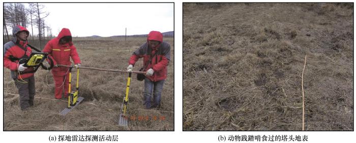
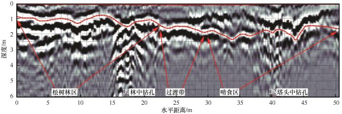
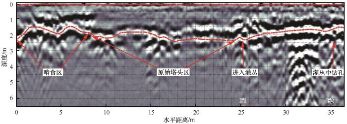
... 目前探地雷达技术是一种成熟的地球物理勘探方法, 用于探测多年冻土地下冰、 冻土结构以及冻土上限等[49-50].探地雷达工作原理为: 不同性质的地层界面处, 上下介质之间的电性(主要是介质体的介电常数值)差异会使雷达波在界面处反射, 然后利用这种反射特征反推地层分布[51].冻土与非冻土之间的电阻率及介电常数的差异很大, 当电磁波遇到冻土层时会产生一个较强的、 不同相位特性的反射波, 在雷达影像上表现为直达波后的强振幅、 同相轴连续性较好的影像层.因此, 探地雷达技术探测多年冻土活动层分布效果很好.探测分两段, 从西向东第一段松树林至塔头区共50.0 m, 第二段从塔头至茂密的灌丛共35.0 m.采用规格为100M的天线并以步长25 cm进行探测, 所获影像通过EKKO-view软件分析, 辅以钻孔资料验证. ...
测地雷达在寒区浅层地质调查中的应用
1
1994
... 目前探地雷达技术是一种成熟的地球物理勘探方法, 用于探测多年冻土地下冰、 冻土结构以及冻土上限等[49-50].探地雷达工作原理为: 不同性质的地层界面处, 上下介质之间的电性(主要是介质体的介电常数值)差异会使雷达波在界面处反射, 然后利用这种反射特征反推地层分布[51].冻土与非冻土之间的电阻率及介电常数的差异很大, 当电磁波遇到冻土层时会产生一个较强的、 不同相位特性的反射波, 在雷达影像上表现为直达波后的强振幅、 同相轴连续性较好的影像层.因此, 探地雷达技术探测多年冻土活动层分布效果很好.探测分两段, 从西向东第一段松树林至塔头区共50.0 m, 第二段从塔头至茂密的灌丛共35.0 m.采用规格为100M的天线并以步长25 cm进行探测, 所获影像通过EKKO-view软件分析, 辅以钻孔资料验证. ...
Using ground-penetrating radar to detect permafrost degradation in the northern limit of permafrost on the Tibetan Plateau
1
2005
... 目前探地雷达技术是一种成熟的地球物理勘探方法, 用于探测多年冻土地下冰、 冻土结构以及冻土上限等[49-50].探地雷达工作原理为: 不同性质的地层界面处, 上下介质之间的电性(主要是介质体的介电常数值)差异会使雷达波在界面处反射, 然后利用这种反射特征反推地层分布[51].冻土与非冻土之间的电阻率及介电常数的差异很大, 当电磁波遇到冻土层时会产生一个较强的、 不同相位特性的反射波, 在雷达影像上表现为直达波后的强振幅、 同相轴连续性较好的影像层.因此, 探地雷达技术探测多年冻土活动层分布效果很好.探测分两段, 从西向东第一段松树林至塔头区共50.0 m, 第二段从塔头至茂密的灌丛共35.0 m.采用规格为100M的天线并以步长25 cm进行探测, 所获影像通过EKKO-view软件分析, 辅以钻孔资料验证. ...
1
1994
... 目前探地雷达技术是一种成熟的地球物理勘探方法, 用于探测多年冻土地下冰、 冻土结构以及冻土上限等[49-50].探地雷达工作原理为: 不同性质的地层界面处, 上下介质之间的电性(主要是介质体的介电常数值)差异会使雷达波在界面处反射, 然后利用这种反射特征反推地层分布[51].冻土与非冻土之间的电阻率及介电常数的差异很大, 当电磁波遇到冻土层时会产生一个较强的、 不同相位特性的反射波, 在雷达影像上表现为直达波后的强振幅、 同相轴连续性较好的影像层.因此, 探地雷达技术探测多年冻土活动层分布效果很好.探测分两段, 从西向东第一段松树林至塔头区共50.0 m, 第二段从塔头至茂密的灌丛共35.0 m.采用规格为100M的天线并以步长25 cm进行探测, 所获影像通过EKKO-view软件分析, 辅以钻孔资料验证. ...
Soil degradation related to overgrazing in the semi-arid southern Caldenal area of Argentina
1
2001
... 从探测结果看, 塔头区活动层最厚, 其次是灌丛和松树林, 这与观测资料基本相符.只是柴桦灌丛较高较密, 极不利于实际过程中探地雷达贴地探测, 100M的天线难以放平稳, 人员行进也十分困难, 只进行到钻孔东侧2.0 m左右的地方, 测量结果与钻孔观测资料比较误差较大.松树林中探测到的活动层有一定波动, 除了树干树根的干扰外, 林中有无树木遮荫、 草本类植物生长的多少和水分的分配都会影响局部小环境内地面温度的高低, 进而导致最大融化深度不一致.塔头区内啃食区明显比原始塔头区活动层波动大, 一来动物的啃食会导致地面失去植被的保护和散发更多的热量, 使得活动层加厚; 二来动物的践踏作用会使土壤总孔隙度减少, 特别是大孔隙(>50 μm)和较大中等孔隙(9 ~ 50 μm)减少[52], 容重增加[53-54], 渗透阻力加大, 保水持水能力下降[55], 地面积水区域, 不利于能量向下传输, 活动层反而变薄, 无积水的地方能量散失快, 活动层相对较厚.原始塔头区土壤物理性质较为均衡, 活动层稳定, 波动不大. ...
Seasonal grazing affects soil physical properties of a montane riparian community
1
2002
... 从探测结果看, 塔头区活动层最厚, 其次是灌丛和松树林, 这与观测资料基本相符.只是柴桦灌丛较高较密, 极不利于实际过程中探地雷达贴地探测, 100M的天线难以放平稳, 人员行进也十分困难, 只进行到钻孔东侧2.0 m左右的地方, 测量结果与钻孔观测资料比较误差较大.松树林中探测到的活动层有一定波动, 除了树干树根的干扰外, 林中有无树木遮荫、 草本类植物生长的多少和水分的分配都会影响局部小环境内地面温度的高低, 进而导致最大融化深度不一致.塔头区内啃食区明显比原始塔头区活动层波动大, 一来动物的啃食会导致地面失去植被的保护和散发更多的热量, 使得活动层加厚; 二来动物的践踏作用会使土壤总孔隙度减少, 特别是大孔隙(>50 μm)和较大中等孔隙(9 ~ 50 μm)减少[52], 容重增加[53-54], 渗透阻力加大, 保水持水能力下降[55], 地面积水区域, 不利于能量向下传输, 活动层反而变薄, 无积水的地方能量散失快, 活动层相对较厚.原始塔头区土壤物理性质较为均衡, 活动层稳定, 波动不大. ...
P contents in plant-soil system
1
1998
... 从探测结果看, 塔头区活动层最厚, 其次是灌丛和松树林, 这与观测资料基本相符.只是柴桦灌丛较高较密, 极不利于实际过程中探地雷达贴地探测, 100M的天线难以放平稳, 人员行进也十分困难, 只进行到钻孔东侧2.0 m左右的地方, 测量结果与钻孔观测资料比较误差较大.松树林中探测到的活动层有一定波动, 除了树干树根的干扰外, 林中有无树木遮荫、 草本类植物生长的多少和水分的分配都会影响局部小环境内地面温度的高低, 进而导致最大融化深度不一致.塔头区内啃食区明显比原始塔头区活动层波动大, 一来动物的啃食会导致地面失去植被的保护和散发更多的热量, 使得活动层加厚; 二来动物的践踏作用会使土壤总孔隙度减少, 特别是大孔隙(>50 μm)和较大中等孔隙(9 ~ 50 μm)减少[52], 容重增加[53-54], 渗透阻力加大, 保水持水能力下降[55], 地面积水区域, 不利于能量向下传输, 活动层反而变薄, 无积水的地方能量散失快, 活动层相对较厚.原始塔头区土壤物理性质较为均衡, 活动层稳定, 波动不大. ...
不同放牧率对草原植物与土壤C、 N、 P含量的影响
1
1998
... 从探测结果看, 塔头区活动层最厚, 其次是灌丛和松树林, 这与观测资料基本相符.只是柴桦灌丛较高较密, 极不利于实际过程中探地雷达贴地探测, 100M的天线难以放平稳, 人员行进也十分困难, 只进行到钻孔东侧2.0 m左右的地方, 测量结果与钻孔观测资料比较误差较大.松树林中探测到的活动层有一定波动, 除了树干树根的干扰外, 林中有无树木遮荫、 草本类植物生长的多少和水分的分配都会影响局部小环境内地面温度的高低, 进而导致最大融化深度不一致.塔头区内啃食区明显比原始塔头区活动层波动大, 一来动物的啃食会导致地面失去植被的保护和散发更多的热量, 使得活动层加厚; 二来动物的践踏作用会使土壤总孔隙度减少, 特别是大孔隙(>50 μm)和较大中等孔隙(9 ~ 50 μm)减少[52], 容重增加[53-54], 渗透阻力加大, 保水持水能力下降[55], 地面积水区域, 不利于能量向下传输, 活动层反而变薄, 无积水的地方能量散失快, 活动层相对较厚.原始塔头区土壤物理性质较为均衡, 活动层稳定, 波动不大. ...
Response of soil properties and microbial biomass to different grazing intensities in temperate typical steppe
1
2018
... 从探测结果看, 塔头区活动层最厚, 其次是灌丛和松树林, 这与观测资料基本相符.只是柴桦灌丛较高较密, 极不利于实际过程中探地雷达贴地探测, 100M的天线难以放平稳, 人员行进也十分困难, 只进行到钻孔东侧2.0 m左右的地方, 测量结果与钻孔观测资料比较误差较大.松树林中探测到的活动层有一定波动, 除了树干树根的干扰外, 林中有无树木遮荫、 草本类植物生长的多少和水分的分配都会影响局部小环境内地面温度的高低, 进而导致最大融化深度不一致.塔头区内啃食区明显比原始塔头区活动层波动大, 一来动物的啃食会导致地面失去植被的保护和散发更多的热量, 使得活动层加厚; 二来动物的践踏作用会使土壤总孔隙度减少, 特别是大孔隙(>50 μm)和较大中等孔隙(9 ~ 50 μm)减少[52], 容重增加[53-54], 渗透阻力加大, 保水持水能力下降[55], 地面积水区域, 不利于能量向下传输, 活动层反而变薄, 无积水的地方能量散失快, 活动层相对较厚.原始塔头区土壤物理性质较为均衡, 活动层稳定, 波动不大. ...
温带典型草原土壤理化性质及微生物量对放牧强度的响应
1
2018
... 从探测结果看, 塔头区活动层最厚, 其次是灌丛和松树林, 这与观测资料基本相符.只是柴桦灌丛较高较密, 极不利于实际过程中探地雷达贴地探测, 100M的天线难以放平稳, 人员行进也十分困难, 只进行到钻孔东侧2.0 m左右的地方, 测量结果与钻孔观测资料比较误差较大.松树林中探测到的活动层有一定波动, 除了树干树根的干扰外, 林中有无树木遮荫、 草本类植物生长的多少和水分的分配都会影响局部小环境内地面温度的高低, 进而导致最大融化深度不一致.塔头区内啃食区明显比原始塔头区活动层波动大, 一来动物的啃食会导致地面失去植被的保护和散发更多的热量, 使得活动层加厚; 二来动物的践踏作用会使土壤总孔隙度减少, 特别是大孔隙(>50 μm)和较大中等孔隙(9 ~ 50 μm)减少[52], 容重增加[53-54], 渗透阻力加大, 保水持水能力下降[55], 地面积水区域, 不利于能量向下传输, 活动层反而变薄, 无积水的地方能量散失快, 活动层相对较厚.原始塔头区土壤物理性质较为均衡, 活动层稳定, 波动不大. ...
The impact of sheep trampling and stocking rate on the physical properties of a red duplex soil with two initially different structures
1
1995
... 这与大兴安岭西坡根河生态站的观测情况正好相反[34], 主要是因为生态站属于原始林, 未有人类和动物的任何破坏, 生态环境及其湿地功能完好, 塔头有良好的吸水保水能力, 避免地面升温降温幅度过高.而位于新林研究区内的塔头由于放牧以及人类活动(如中俄输油管线工程施工、 加漠公路从旁边穿过)影响, 地表植被破坏, 土壤孔隙度减小, 密实度增大[56-57], 地表积水和蒸发增大, 导热能力增加[58], 地温偏高.这里的松树林冠层大, 能够有效阻挡到达地面的直接太阳辐射, 并且形成阴影降低地面温度, 使得松树林地温较低.灌丛密度大, 同样可以有效阻挡太阳辐射, 又有大量的原始塔头草覆被地表, 吸水保水能力增强, 灌丛钻孔岩芯富冰层厚达9 m, 这样既能阻碍夏季地温升高, 又使地层冬季散失较多热量, 因此尽管表层温度略高于松树林, 其他深度处的地温还是很低. ...
Long-term stocking rate effects on soil physical properties
1
1997
... 这与大兴安岭西坡根河生态站的观测情况正好相反[34], 主要是因为生态站属于原始林, 未有人类和动物的任何破坏, 生态环境及其湿地功能完好, 塔头有良好的吸水保水能力, 避免地面升温降温幅度过高.而位于新林研究区内的塔头由于放牧以及人类活动(如中俄输油管线工程施工、 加漠公路从旁边穿过)影响, 地表植被破坏, 土壤孔隙度减小, 密实度增大[56-57], 地表积水和蒸发增大, 导热能力增加[58], 地温偏高.这里的松树林冠层大, 能够有效阻挡到达地面的直接太阳辐射, 并且形成阴影降低地面温度, 使得松树林地温较低.灌丛密度大, 同样可以有效阻挡太阳辐射, 又有大量的原始塔头草覆被地表, 吸水保水能力增强, 灌丛钻孔岩芯富冰层厚达9 m, 这样既能阻碍夏季地温升高, 又使地层冬季散失较多热量, 因此尽管表层温度略高于松树林, 其他深度处的地温还是很低. ...
Review of status and progress of the study in thermal conductivity of frozen soil
1
2018
... 这与大兴安岭西坡根河生态站的观测情况正好相反[34], 主要是因为生态站属于原始林, 未有人类和动物的任何破坏, 生态环境及其湿地功能完好, 塔头有良好的吸水保水能力, 避免地面升温降温幅度过高.而位于新林研究区内的塔头由于放牧以及人类活动(如中俄输油管线工程施工、 加漠公路从旁边穿过)影响, 地表植被破坏, 土壤孔隙度减小, 密实度增大[56-57], 地表积水和蒸发增大, 导热能力增加[58], 地温偏高.这里的松树林冠层大, 能够有效阻挡到达地面的直接太阳辐射, 并且形成阴影降低地面温度, 使得松树林地温较低.灌丛密度大, 同样可以有效阻挡太阳辐射, 又有大量的原始塔头草覆被地表, 吸水保水能力增强, 灌丛钻孔岩芯富冰层厚达9 m, 这样既能阻碍夏季地温升高, 又使地层冬季散失较多热量, 因此尽管表层温度略高于松树林, 其他深度处的地温还是很低. ...
冻土导热系数研究现状及进展
1
2018
... 这与大兴安岭西坡根河生态站的观测情况正好相反[34], 主要是因为生态站属于原始林, 未有人类和动物的任何破坏, 生态环境及其湿地功能完好, 塔头有良好的吸水保水能力, 避免地面升温降温幅度过高.而位于新林研究区内的塔头由于放牧以及人类活动(如中俄输油管线工程施工、 加漠公路从旁边穿过)影响, 地表植被破坏, 土壤孔隙度减小, 密实度增大[56-57], 地表积水和蒸发增大, 导热能力增加[58], 地温偏高.这里的松树林冠层大, 能够有效阻挡到达地面的直接太阳辐射, 并且形成阴影降低地面温度, 使得松树林地温较低.灌丛密度大, 同样可以有效阻挡太阳辐射, 又有大量的原始塔头草覆被地表, 吸水保水能力增强, 灌丛钻孔岩芯富冰层厚达9 m, 这样既能阻碍夏季地温升高, 又使地层冬季散失较多热量, 因此尽管表层温度略高于松树林, 其他深度处的地温还是很低. ...
On the zonation of high-altitude permafrost in China
1
1982
... 多年冻土厚度与年平均地温关系密切.程国栋等[59]统计分析(以下称程氏推算)青藏高原多年冻土厚度(H, m)与年平均地温(th, ℃)间的关系, 公式为: H=15.91-31.43th (相关系数R=0.94); 童长江等[60](以下称童氏推算)也统计了我国西部地区多年冻土厚度与年平均地温之间的关系, 所得公式为: H=15.84-27.17th (相关系数R=0.94).目前东北地区还没有这种关系的统计.根据上述两种推算和地温梯度得到松树林-塔头-灌丛下伏多年冻土厚度的结果如表2. ...
试论中国高海拔多年冻土带的划分
1
1982
... 多年冻土厚度与年平均地温关系密切.程国栋等[59]统计分析(以下称程氏推算)青藏高原多年冻土厚度(H, m)与年平均地温(th, ℃)间的关系, 公式为: H=15.91-31.43th (相关系数R=0.94); 童长江等[60](以下称童氏推算)也统计了我国西部地区多年冻土厚度与年平均地温之间的关系, 所得公式为: H=15.84-27.17th (相关系数R=0.94).目前东北地区还没有这种关系的统计.根据上述两种推算和地温梯度得到松树林-塔头-灌丛下伏多年冻土厚度的结果如表2. ...
Permafrost zonation of ground temperature and stability of engineering constructions in the western region, China
1
1996
... 多年冻土厚度与年平均地温关系密切.程国栋等[59]统计分析(以下称程氏推算)青藏高原多年冻土厚度(H, m)与年平均地温(th, ℃)间的关系, 公式为: H=15.91-31.43th (相关系数R=0.94); 童长江等[60](以下称童氏推算)也统计了我国西部地区多年冻土厚度与年平均地温之间的关系, 所得公式为: H=15.84-27.17th (相关系数R=0.94).目前东北地区还没有这种关系的统计.根据上述两种推算和地温梯度得到松树林-塔头-灌丛下伏多年冻土厚度的结果如表2. ...
我国西部多年冻土地温带与工程建筑物稳定性
1
1996
... 多年冻土厚度与年平均地温关系密切.程国栋等[59]统计分析(以下称程氏推算)青藏高原多年冻土厚度(H, m)与年平均地温(th, ℃)间的关系, 公式为: H=15.91-31.43th (相关系数R=0.94); 童长江等[60](以下称童氏推算)也统计了我国西部地区多年冻土厚度与年平均地温之间的关系, 所得公式为: H=15.84-27.17th (相关系数R=0.94).目前东北地区还没有这种关系的统计.根据上述两种推算和地温梯度得到松树林-塔头-灌丛下伏多年冻土厚度的结果如表2. ...
Characteristics of ground temperature in permafrost areas in the northern part of Great Xin’an Mountain
1
1982
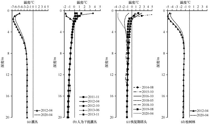
... 冻土层地温曲线状态是内部与外部条件热力交换过程的真实记录, 它反映了冻土层生成、 存在环境和发展趋势.冻土层在其生命的不同时期地温曲线状态在不断变化, 戴竞波[61]将年变化深度以下的地温曲线划分为四种类型, 即正梯度型、 负梯度型、 零梯度型和扭曲型.这四种地温曲线类型在新林区钻孔地温监测中均有体现. ...
大兴安岭北部多年冻土地区地温特征
1
1982
... 冻土层地温曲线状态是内部与外部条件热力交换过程的真实记录, 它反映了冻土层生成、 存在环境和发展趋势.冻土层在其生命的不同时期地温曲线状态在不断变化, 戴竞波[61]将年变化深度以下的地温曲线划分为四种类型, 即正梯度型、 负梯度型、 零梯度型和扭曲型.这四种地温曲线类型在新林区钻孔地温监测中均有体现. ...
The impacts of climate change and human activities on alpine vegetation and permafrost in the Qinghai-Tibet Engineering Corridor
1
2018
... 上述地温曲线类型大致可以反映植被和人为活动影响下新林林区的多年冻土退化情况, 显然人为活动对新林多年冻土活动层厚度及退化状态有至关重要的作用.无独有偶, 2001年后青藏工程走廊中激增的居民和旅客使当地生态恶化, 多年冻土活动层加深[62].同时, 大型工程活动还会影响深层地温, 弱化地表植被的隔热效应[63].无论是哪种情况, 人为活动可以通过改变多年冻土区近地表植被类型以及相应的水分能量平衡来影响冻土变化特征, 只是影响程度较难定量确定, 取决于活动量的大小和持续程度, 以及植被气候等其他综合因素. ...
Thermal impacts of engineering activities and vegetation layer on permafrost in different alpine ecosystems of the Qinghai-Tibet Plateau, China
1
2016
... 上述地温曲线类型大致可以反映植被和人为活动影响下新林林区的多年冻土退化情况, 显然人为活动对新林多年冻土活动层厚度及退化状态有至关重要的作用.无独有偶, 2001年后青藏工程走廊中激增的居民和旅客使当地生态恶化, 多年冻土活动层加深[62].同时, 大型工程活动还会影响深层地温, 弱化地表植被的隔热效应[63].无论是哪种情况, 人为活动可以通过改变多年冻土区近地表植被类型以及相应的水分能量平衡来影响冻土变化特征, 只是影响程度较难定量确定, 取决于活动量的大小和持续程度, 以及植被气候等其他综合因素. ...


 甘公网安备 62010202000676号