Effects of water vapor source and local evaporation on the stable hydrogen and oxygen isotopic compositions of precipitation
1
2019
... 水循环是水圈中重要的能量和物质流动的形式[1], 降水又是水循环过程中最主要的环节[2].黑河是我国第二大内陆河, 保障着流域内人们的生活, 然而受气候变化和人为活动的影响, 水资源十分短缺, 流域大部分属干旱气候区, 仅上游的祁连山区较湿润, 是流域内降水的主要发生区和径流的主要形成区[3].其次, 近年来流域内强降水事件的强度和频率加大[4], 使得原本脆弱不堪的水系统变得更不稳定[5], 鉴于此, 对黑河上游研究时段内降水持续时间最长和降水量最大的几次典型降水事件进行了分析研究[4].因此, 对黑河上游降水进行分析研究可以为该区域乃至整个西北干旱区环境保护和水汽循环模式提供理论支撑[6].氢氧稳定同位素作为水分子的重要组成部分, 对环境变化的响应十分敏感, 已成为研究复杂的水文和气候过程的有效手段[7-8]. ...
水汽源地和局地蒸发对大气降水氢氧稳定同位素组分的影响
1
2019
... 水循环是水圈中重要的能量和物质流动的形式[1], 降水又是水循环过程中最主要的环节[2].黑河是我国第二大内陆河, 保障着流域内人们的生活, 然而受气候变化和人为活动的影响, 水资源十分短缺, 流域大部分属干旱气候区, 仅上游的祁连山区较湿润, 是流域内降水的主要发生区和径流的主要形成区[3].其次, 近年来流域内强降水事件的强度和频率加大[4], 使得原本脆弱不堪的水系统变得更不稳定[5], 鉴于此, 对黑河上游研究时段内降水持续时间最长和降水量最大的几次典型降水事件进行了分析研究[4].因此, 对黑河上游降水进行分析研究可以为该区域乃至整个西北干旱区环境保护和水汽循环模式提供理论支撑[6].氢氧稳定同位素作为水分子的重要组成部分, 对环境变化的响应十分敏感, 已成为研究复杂的水文和气候过程的有效手段[7-8]. ...
Characteristics of δD and δ 18O in summer precipitation in the west ordos desert and its water vapor sources
1
2016
... 水循环是水圈中重要的能量和物质流动的形式[1], 降水又是水循环过程中最主要的环节[2].黑河是我国第二大内陆河, 保障着流域内人们的生活, 然而受气候变化和人为活动的影响, 水资源十分短缺, 流域大部分属干旱气候区, 仅上游的祁连山区较湿润, 是流域内降水的主要发生区和径流的主要形成区[3].其次, 近年来流域内强降水事件的强度和频率加大[4], 使得原本脆弱不堪的水系统变得更不稳定[5], 鉴于此, 对黑河上游研究时段内降水持续时间最长和降水量最大的几次典型降水事件进行了分析研究[4].因此, 对黑河上游降水进行分析研究可以为该区域乃至整个西北干旱区环境保护和水汽循环模式提供理论支撑[6].氢氧稳定同位素作为水分子的重要组成部分, 对环境变化的响应十分敏感, 已成为研究复杂的水文和气候过程的有效手段[7-8]. ...
西鄂尔多斯荒漠夏季大气降水氢氧同位素特征与水汽来源
1
2016
... 水循环是水圈中重要的能量和物质流动的形式[1], 降水又是水循环过程中最主要的环节[2].黑河是我国第二大内陆河, 保障着流域内人们的生活, 然而受气候变化和人为活动的影响, 水资源十分短缺, 流域大部分属干旱气候区, 仅上游的祁连山区较湿润, 是流域内降水的主要发生区和径流的主要形成区[3].其次, 近年来流域内强降水事件的强度和频率加大[4], 使得原本脆弱不堪的水系统变得更不稳定[5], 鉴于此, 对黑河上游研究时段内降水持续时间最长和降水量最大的几次典型降水事件进行了分析研究[4].因此, 对黑河上游降水进行分析研究可以为该区域乃至整个西北干旱区环境保护和水汽循环模式提供理论支撑[6].氢氧稳定同位素作为水分子的重要组成部分, 对环境变化的响应十分敏感, 已成为研究复杂的水文和气候过程的有效手段[7-8]. ...
Water vapor sources precipitation in the upper reaches of Heihe River: evidence from stable water isotopes and air mass trajectory model
3
2016
... 水循环是水圈中重要的能量和物质流动的形式[1], 降水又是水循环过程中最主要的环节[2].黑河是我国第二大内陆河, 保障着流域内人们的生活, 然而受气候变化和人为活动的影响, 水资源十分短缺, 流域大部分属干旱气候区, 仅上游的祁连山区较湿润, 是流域内降水的主要发生区和径流的主要形成区[3].其次, 近年来流域内强降水事件的强度和频率加大[4], 使得原本脆弱不堪的水系统变得更不稳定[5], 鉴于此, 对黑河上游研究时段内降水持续时间最长和降水量最大的几次典型降水事件进行了分析研究[4].因此, 对黑河上游降水进行分析研究可以为该区域乃至整个西北干旱区环境保护和水汽循环模式提供理论支撑[6].氢氧稳定同位素作为水分子的重要组成部分, 对环境变化的响应十分敏感, 已成为研究复杂的水文和气候过程的有效手段[7-8]. ...
... 降水稳定同位素值夏高东低是由于研究区为内陆区, 季节变化明显[43].黑河上游大气水线方程的斜率和截距(δD=8.02δ18O+11.02)较整个黑河流域[17](δD=7.82δ18O+7.63)大, 这可能与黑河流域的中游平原和下游的山地戈壁[14]较上游的祁连山区干燥有关, 可以发现, 本文研究结果与相关研究在上游站点的大气水线(西水: δD=7.96δ18O+13.79[16], 野牛沟: δD=7.65δ18O+12.40[18], 祁连: δD=8.29δ18O+17.13[3])相差不大, 此外, 斜率和截距均略高于全球大气水线说明黑河上游整体上气候较为湿润, 受一定的海洋性水汽影响[40].Liu等[44]研究发现西北地区降水的温度效应明显, 降水量效应弱, 相关研究[17,43]均表明在研究区存在温度效应, 不存在降水量效应, 这主要是因为研究区夏季降水量较大, 但是温度较高使得降水蒸发强烈, 再加上局地蒸发水汽的混入, 使得夏季呈现出降水量大但降水同位素值也高的现象.而在冬季, 水汽主要来源于高纬度地区, 同位素贫化, 再加上温度低且降水多为固态, 蒸发弱, 所以降水量小但同位素值也小, 符合同位素经典理论, 即降水量效应在低纬度地区较明显, 中高纬度地区主要受温度效应控制[45]. ...
... 姚檀栋等[46]将青藏高原分为三个区, 黑河上游位于西风区(35° N以北), 受西风主导, 从本文研究结果看, 研究区全年受西风水汽影响显著, 夏季水汽来源较复杂[16], 会受一定程度的季风水汽影响[3], 这与前人研究结果一致[46-49].研究区夏季降水受局地蒸发水汽影响较大[43,50], 本文研究得出的潜在蒸发源地集中在一些蒸发量较大或相对湿度大的地区, 且均位于水汽运移路径上, 局地蒸发水汽随气流被输送到研究区[20].d-excess在潜在蒸发源地的鉴别及典型降水事件中的应用反映出了d-excess在鉴别水汽来源问题上的优越性[51]. ...
基于D、 18O同位素和HYSPLIT4气团轨迹模型的黑河上游降水水汽来源研究
3
2016
... 水循环是水圈中重要的能量和物质流动的形式[1], 降水又是水循环过程中最主要的环节[2].黑河是我国第二大内陆河, 保障着流域内人们的生活, 然而受气候变化和人为活动的影响, 水资源十分短缺, 流域大部分属干旱气候区, 仅上游的祁连山区较湿润, 是流域内降水的主要发生区和径流的主要形成区[3].其次, 近年来流域内强降水事件的强度和频率加大[4], 使得原本脆弱不堪的水系统变得更不稳定[5], 鉴于此, 对黑河上游研究时段内降水持续时间最长和降水量最大的几次典型降水事件进行了分析研究[4].因此, 对黑河上游降水进行分析研究可以为该区域乃至整个西北干旱区环境保护和水汽循环模式提供理论支撑[6].氢氧稳定同位素作为水分子的重要组成部分, 对环境变化的响应十分敏感, 已成为研究复杂的水文和气候过程的有效手段[7-8]. ...
... 降水稳定同位素值夏高东低是由于研究区为内陆区, 季节变化明显[43].黑河上游大气水线方程的斜率和截距(δD=8.02δ18O+11.02)较整个黑河流域[17](δD=7.82δ18O+7.63)大, 这可能与黑河流域的中游平原和下游的山地戈壁[14]较上游的祁连山区干燥有关, 可以发现, 本文研究结果与相关研究在上游站点的大气水线(西水: δD=7.96δ18O+13.79[16], 野牛沟: δD=7.65δ18O+12.40[18], 祁连: δD=8.29δ18O+17.13[3])相差不大, 此外, 斜率和截距均略高于全球大气水线说明黑河上游整体上气候较为湿润, 受一定的海洋性水汽影响[40].Liu等[44]研究发现西北地区降水的温度效应明显, 降水量效应弱, 相关研究[17,43]均表明在研究区存在温度效应, 不存在降水量效应, 这主要是因为研究区夏季降水量较大, 但是温度较高使得降水蒸发强烈, 再加上局地蒸发水汽的混入, 使得夏季呈现出降水量大但降水同位素值也高的现象.而在冬季, 水汽主要来源于高纬度地区, 同位素贫化, 再加上温度低且降水多为固态, 蒸发弱, 所以降水量小但同位素值也小, 符合同位素经典理论, 即降水量效应在低纬度地区较明显, 中高纬度地区主要受温度效应控制[45]. ...
... 姚檀栋等[46]将青藏高原分为三个区, 黑河上游位于西风区(35° N以北), 受西风主导, 从本文研究结果看, 研究区全年受西风水汽影响显著, 夏季水汽来源较复杂[16], 会受一定程度的季风水汽影响[3], 这与前人研究结果一致[46-49].研究区夏季降水受局地蒸发水汽影响较大[43,50], 本文研究得出的潜在蒸发源地集中在一些蒸发量较大或相对湿度大的地区, 且均位于水汽运移路径上, 局地蒸发水汽随气流被输送到研究区[20].d-excess在潜在蒸发源地的鉴别及典型降水事件中的应用反映出了d-excess在鉴别水汽来源问题上的优越性[51]. ...
Study on the isotopes and moisture source in precipitation in the Shule River basin
2
2017
... 水循环是水圈中重要的能量和物质流动的形式[1], 降水又是水循环过程中最主要的环节[2].黑河是我国第二大内陆河, 保障着流域内人们的生活, 然而受气候变化和人为活动的影响, 水资源十分短缺, 流域大部分属干旱气候区, 仅上游的祁连山区较湿润, 是流域内降水的主要发生区和径流的主要形成区[3].其次, 近年来流域内强降水事件的强度和频率加大[4], 使得原本脆弱不堪的水系统变得更不稳定[5], 鉴于此, 对黑河上游研究时段内降水持续时间最长和降水量最大的几次典型降水事件进行了分析研究[4].因此, 对黑河上游降水进行分析研究可以为该区域乃至整个西北干旱区环境保护和水汽循环模式提供理论支撑[6].氢氧稳定同位素作为水分子的重要组成部分, 对环境变化的响应十分敏感, 已成为研究复杂的水文和气候过程的有效手段[7-8]. ...
... [4].因此, 对黑河上游降水进行分析研究可以为该区域乃至整个西北干旱区环境保护和水汽循环模式提供理论支撑[6].氢氧稳定同位素作为水分子的重要组成部分, 对环境变化的响应十分敏感, 已成为研究复杂的水文和气候过程的有效手段[7-8]. ...
疏勒河流域大气降水同位素特征及水汽来源研究
2
2017
... 水循环是水圈中重要的能量和物质流动的形式[1], 降水又是水循环过程中最主要的环节[2].黑河是我国第二大内陆河, 保障着流域内人们的生活, 然而受气候变化和人为活动的影响, 水资源十分短缺, 流域大部分属干旱气候区, 仅上游的祁连山区较湿润, 是流域内降水的主要发生区和径流的主要形成区[3].其次, 近年来流域内强降水事件的强度和频率加大[4], 使得原本脆弱不堪的水系统变得更不稳定[5], 鉴于此, 对黑河上游研究时段内降水持续时间最长和降水量最大的几次典型降水事件进行了分析研究[4].因此, 对黑河上游降水进行分析研究可以为该区域乃至整个西北干旱区环境保护和水汽循环模式提供理论支撑[6].氢氧稳定同位素作为水分子的重要组成部分, 对环境变化的响应十分敏感, 已成为研究复杂的水文和气候过程的有效手段[7-8]. ...
... [4].因此, 对黑河上游降水进行分析研究可以为该区域乃至整个西北干旱区环境保护和水汽循环模式提供理论支撑[6].氢氧稳定同位素作为水分子的重要组成部分, 对环境变化的响应十分敏感, 已成为研究复杂的水文和气候过程的有效手段[7-8]. ...
Status and suggestions on ecological protection and restoration of Qilian Mountains
1
2017
... 水循环是水圈中重要的能量和物质流动的形式[1], 降水又是水循环过程中最主要的环节[2].黑河是我国第二大内陆河, 保障着流域内人们的生活, 然而受气候变化和人为活动的影响, 水资源十分短缺, 流域大部分属干旱气候区, 仅上游的祁连山区较湿润, 是流域内降水的主要发生区和径流的主要形成区[3].其次, 近年来流域内强降水事件的强度和频率加大[4], 使得原本脆弱不堪的水系统变得更不稳定[5], 鉴于此, 对黑河上游研究时段内降水持续时间最长和降水量最大的几次典型降水事件进行了分析研究[4].因此, 对黑河上游降水进行分析研究可以为该区域乃至整个西北干旱区环境保护和水汽循环模式提供理论支撑[6].氢氧稳定同位素作为水分子的重要组成部分, 对环境变化的响应十分敏感, 已成为研究复杂的水文和气候过程的有效手段[7-8]. ...
祁连山生态保护与修复的现状问题与建议
1
2017
... 水循环是水圈中重要的能量和物质流动的形式[1], 降水又是水循环过程中最主要的环节[2].黑河是我国第二大内陆河, 保障着流域内人们的生活, 然而受气候变化和人为活动的影响, 水资源十分短缺, 流域大部分属干旱气候区, 仅上游的祁连山区较湿润, 是流域内降水的主要发生区和径流的主要形成区[3].其次, 近年来流域内强降水事件的强度和频率加大[4], 使得原本脆弱不堪的水系统变得更不稳定[5], 鉴于此, 对黑河上游研究时段内降水持续时间最长和降水量最大的几次典型降水事件进行了分析研究[4].因此, 对黑河上游降水进行分析研究可以为该区域乃至整个西北干旱区环境保护和水汽循环模式提供理论支撑[6].氢氧稳定同位素作为水分子的重要组成部分, 对环境变化的响应十分敏感, 已成为研究复杂的水文和气候过程的有效手段[7-8]. ...
Isotopic characteristics of precipitation and source analysis of water vapor in the middle Qilian Mountains
2
2019
... 水循环是水圈中重要的能量和物质流动的形式[1], 降水又是水循环过程中最主要的环节[2].黑河是我国第二大内陆河, 保障着流域内人们的生活, 然而受气候变化和人为活动的影响, 水资源十分短缺, 流域大部分属干旱气候区, 仅上游的祁连山区较湿润, 是流域内降水的主要发生区和径流的主要形成区[3].其次, 近年来流域内强降水事件的强度和频率加大[4], 使得原本脆弱不堪的水系统变得更不稳定[5], 鉴于此, 对黑河上游研究时段内降水持续时间最长和降水量最大的几次典型降水事件进行了分析研究[4].因此, 对黑河上游降水进行分析研究可以为该区域乃至整个西北干旱区环境保护和水汽循环模式提供理论支撑[6].氢氧稳定同位素作为水分子的重要组成部分, 对环境变化的响应十分敏感, 已成为研究复杂的水文和气候过程的有效手段[7-8]. ...
... 式中: α18w-v 和α2w-v 是水和水蒸气氢氧同位素之间的平衡分馏系数, 和温度T(K)存在以下关系[6,22,25]: ...
祁连山中段降水同位素特征及水汽来源分析
2
2019
... 水循环是水圈中重要的能量和物质流动的形式[1], 降水又是水循环过程中最主要的环节[2].黑河是我国第二大内陆河, 保障着流域内人们的生活, 然而受气候变化和人为活动的影响, 水资源十分短缺, 流域大部分属干旱气候区, 仅上游的祁连山区较湿润, 是流域内降水的主要发生区和径流的主要形成区[3].其次, 近年来流域内强降水事件的强度和频率加大[4], 使得原本脆弱不堪的水系统变得更不稳定[5], 鉴于此, 对黑河上游研究时段内降水持续时间最长和降水量最大的几次典型降水事件进行了分析研究[4].因此, 对黑河上游降水进行分析研究可以为该区域乃至整个西北干旱区环境保护和水汽循环模式提供理论支撑[6].氢氧稳定同位素作为水分子的重要组成部分, 对环境变化的响应十分敏感, 已成为研究复杂的水文和气候过程的有效手段[7-8]. ...
... 式中: α18w-v 和α2w-v 是水和水蒸气氢氧同位素之间的平衡分馏系数, 和温度T(K)存在以下关系[6,22,25]: ...
Incorporating water isoscapes in hydrological and water resource investigations
1
2015
... 水循环是水圈中重要的能量和物质流动的形式[1], 降水又是水循环过程中最主要的环节[2].黑河是我国第二大内陆河, 保障着流域内人们的生活, 然而受气候变化和人为活动的影响, 水资源十分短缺, 流域大部分属干旱气候区, 仅上游的祁连山区较湿润, 是流域内降水的主要发生区和径流的主要形成区[3].其次, 近年来流域内强降水事件的强度和频率加大[4], 使得原本脆弱不堪的水系统变得更不稳定[5], 鉴于此, 对黑河上游研究时段内降水持续时间最长和降水量最大的几次典型降水事件进行了分析研究[4].因此, 对黑河上游降水进行分析研究可以为该区域乃至整个西北干旱区环境保护和水汽循环模式提供理论支撑[6].氢氧稳定同位素作为水分子的重要组成部分, 对环境变化的响应十分敏感, 已成为研究复杂的水文和气候过程的有效手段[7-8]. ...
A review of precipitation isotope studies in China: basic pattern and hydrological process
1
2016
... 水循环是水圈中重要的能量和物质流动的形式[1], 降水又是水循环过程中最主要的环节[2].黑河是我国第二大内陆河, 保障着流域内人们的生活, 然而受气候变化和人为活动的影响, 水资源十分短缺, 流域大部分属干旱气候区, 仅上游的祁连山区较湿润, 是流域内降水的主要发生区和径流的主要形成区[3].其次, 近年来流域内强降水事件的强度和频率加大[4], 使得原本脆弱不堪的水系统变得更不稳定[5], 鉴于此, 对黑河上游研究时段内降水持续时间最长和降水量最大的几次典型降水事件进行了分析研究[4].因此, 对黑河上游降水进行分析研究可以为该区域乃至整个西北干旱区环境保护和水汽循环模式提供理论支撑[6].氢氧稳定同位素作为水分子的重要组成部分, 对环境变化的响应十分敏感, 已成为研究复杂的水文和气候过程的有效手段[7-8]. ...
Analysis of water vapor transport characteristics during the Meiyu over the Yangtze-Huaihe River valley using the Lagrangian method
1
2013
... 目前, 水汽来源分析方法主要有: HYSPLIT和FLEXPART模式[9-10]、 同位素分析法[11]和欧拉方法[12]等, 大都使用单一方法进行分析.关于黑河上游及其周边地区降水同位素和水汽来源已有不少研究[13-18], 但水汽来源鉴定方法较传统, 运用同位素和水汽来源方法综合研究典型降水事件也不多见.综上, 本文除对研究区降水同位素特征进行分析外, 重点在水汽来源方面, 将后向轨迹和水汽d-excess(d-excess=δD-8δ18O)数据结合起来, 使用潜在源贡献因子(potential source contribution function, PSCF)分析法定性分析了研究区夏季降水的潜在蒸发源区, 已有学者[19-20]利用类似方法进行了各自研究区的潜在蒸发源地的研究, 表明了此方法在水汽源地鉴定方面的适用性[21].此方法的优越性在于d-excess的影响因素较少, 蒸发形成的水汽d-excess值很高, 可以明显区别于水体的d-excess[22], 此外, PSCF的可视化分析结果, 便于理解和识别潜在蒸发源区, 对于理解区域水汽循环过程具有深刻意义. ...
基于拉格朗日方法的江淮梅雨水汽输送特征分析
1
2013
... 目前, 水汽来源分析方法主要有: HYSPLIT和FLEXPART模式[9-10]、 同位素分析法[11]和欧拉方法[12]等, 大都使用单一方法进行分析.关于黑河上游及其周边地区降水同位素和水汽来源已有不少研究[13-18], 但水汽来源鉴定方法较传统, 运用同位素和水汽来源方法综合研究典型降水事件也不多见.综上, 本文除对研究区降水同位素特征进行分析外, 重点在水汽来源方面, 将后向轨迹和水汽d-excess(d-excess=δD-8δ18O)数据结合起来, 使用潜在源贡献因子(potential source contribution function, PSCF)分析法定性分析了研究区夏季降水的潜在蒸发源区, 已有学者[19-20]利用类似方法进行了各自研究区的潜在蒸发源地的研究, 表明了此方法在水汽源地鉴定方面的适用性[21].此方法的优越性在于d-excess的影响因素较少, 蒸发形成的水汽d-excess值很高, 可以明显区别于水体的d-excess[22], 此外, PSCF的可视化分析结果, 便于理解和识别潜在蒸发源区, 对于理解区域水汽循环过程具有深刻意义. ...
Application of Lagrange water vapor source diagnosis method to the Three-river Source Area
1
2016
... 目前, 水汽来源分析方法主要有: HYSPLIT和FLEXPART模式[9-10]、 同位素分析法[11]和欧拉方法[12]等, 大都使用单一方法进行分析.关于黑河上游及其周边地区降水同位素和水汽来源已有不少研究[13-18], 但水汽来源鉴定方法较传统, 运用同位素和水汽来源方法综合研究典型降水事件也不多见.综上, 本文除对研究区降水同位素特征进行分析外, 重点在水汽来源方面, 将后向轨迹和水汽d-excess(d-excess=δD-8δ18O)数据结合起来, 使用潜在源贡献因子(potential source contribution function, PSCF)分析法定性分析了研究区夏季降水的潜在蒸发源区, 已有学者[19-20]利用类似方法进行了各自研究区的潜在蒸发源地的研究, 表明了此方法在水汽源地鉴定方面的适用性[21].此方法的优越性在于d-excess的影响因素较少, 蒸发形成的水汽d-excess值很高, 可以明显区别于水体的d-excess[22], 此外, PSCF的可视化分析结果, 便于理解和识别潜在蒸发源区, 对于理解区域水汽循环过程具有深刻意义. ...
拉格朗日水汽源诊断方法在三江源区的应用
1
2016
... 目前, 水汽来源分析方法主要有: HYSPLIT和FLEXPART模式[9-10]、 同位素分析法[11]和欧拉方法[12]等, 大都使用单一方法进行分析.关于黑河上游及其周边地区降水同位素和水汽来源已有不少研究[13-18], 但水汽来源鉴定方法较传统, 运用同位素和水汽来源方法综合研究典型降水事件也不多见.综上, 本文除对研究区降水同位素特征进行分析外, 重点在水汽来源方面, 将后向轨迹和水汽d-excess(d-excess=δD-8δ18O)数据结合起来, 使用潜在源贡献因子(potential source contribution function, PSCF)分析法定性分析了研究区夏季降水的潜在蒸发源区, 已有学者[19-20]利用类似方法进行了各自研究区的潜在蒸发源地的研究, 表明了此方法在水汽源地鉴定方面的适用性[21].此方法的优越性在于d-excess的影响因素较少, 蒸发形成的水汽d-excess值很高, 可以明显区别于水体的d-excess[22], 此外, PSCF的可视化分析结果, 便于理解和识别潜在蒸发源区, 对于理解区域水汽循环过程具有深刻意义. ...
A review of climatic controls on δ 18O in precipitation over the Tibetan Plateau: observations and simulations
1
2013
... 目前, 水汽来源分析方法主要有: HYSPLIT和FLEXPART模式[9-10]、 同位素分析法[11]和欧拉方法[12]等, 大都使用单一方法进行分析.关于黑河上游及其周边地区降水同位素和水汽来源已有不少研究[13-18], 但水汽来源鉴定方法较传统, 运用同位素和水汽来源方法综合研究典型降水事件也不多见.综上, 本文除对研究区降水同位素特征进行分析外, 重点在水汽来源方面, 将后向轨迹和水汽d-excess(d-excess=δD-8δ18O)数据结合起来, 使用潜在源贡献因子(potential source contribution function, PSCF)分析法定性分析了研究区夏季降水的潜在蒸发源区, 已有学者[19-20]利用类似方法进行了各自研究区的潜在蒸发源地的研究, 表明了此方法在水汽源地鉴定方面的适用性[21].此方法的优越性在于d-excess的影响因素较少, 蒸发形成的水汽d-excess值很高, 可以明显区别于水体的d-excess[22], 此外, PSCF的可视化分析结果, 便于理解和识别潜在蒸发源区, 对于理解区域水汽循环过程具有深刻意义. ...
Genesis analysis of short-time heavy rainfall in Qilian Mountains
1
... 目前, 水汽来源分析方法主要有: HYSPLIT和FLEXPART模式[9-10]、 同位素分析法[11]和欧拉方法[12]等, 大都使用单一方法进行分析.关于黑河上游及其周边地区降水同位素和水汽来源已有不少研究[13-18], 但水汽来源鉴定方法较传统, 运用同位素和水汽来源方法综合研究典型降水事件也不多见.综上, 本文除对研究区降水同位素特征进行分析外, 重点在水汽来源方面, 将后向轨迹和水汽d-excess(d-excess=δD-8δ18O)数据结合起来, 使用潜在源贡献因子(potential source contribution function, PSCF)分析法定性分析了研究区夏季降水的潜在蒸发源区, 已有学者[19-20]利用类似方法进行了各自研究区的潜在蒸发源地的研究, 表明了此方法在水汽源地鉴定方面的适用性[21].此方法的优越性在于d-excess的影响因素较少, 蒸发形成的水汽d-excess值很高, 可以明显区别于水体的d-excess[22], 此外, PSCF的可视化分析结果, 便于理解和识别潜在蒸发源区, 对于理解区域水汽循环过程具有深刻意义. ...
祁连山区短时强降水天气过程成因分析
1
2016
... 目前, 水汽来源分析方法主要有: HYSPLIT和FLEXPART模式[9-10]、 同位素分析法[11]和欧拉方法[12]等, 大都使用单一方法进行分析.关于黑河上游及其周边地区降水同位素和水汽来源已有不少研究[13-18], 但水汽来源鉴定方法较传统, 运用同位素和水汽来源方法综合研究典型降水事件也不多见.综上, 本文除对研究区降水同位素特征进行分析外, 重点在水汽来源方面, 将后向轨迹和水汽d-excess(d-excess=δD-8δ18O)数据结合起来, 使用潜在源贡献因子(potential source contribution function, PSCF)分析法定性分析了研究区夏季降水的潜在蒸发源区, 已有学者[19-20]利用类似方法进行了各自研究区的潜在蒸发源地的研究, 表明了此方法在水汽源地鉴定方面的适用性[21].此方法的优越性在于d-excess的影响因素较少, 蒸发形成的水汽d-excess值很高, 可以明显区别于水体的d-excess[22], 此外, PSCF的可视化分析结果, 便于理解和识别潜在蒸发源区, 对于理解区域水汽循环过程具有深刻意义. ...
Oxygen and hydrogen isotopes in precipitation in Heihe River basin, China
1
2009
... 目前, 水汽来源分析方法主要有: HYSPLIT和FLEXPART模式[9-10]、 同位素分析法[11]和欧拉方法[12]等, 大都使用单一方法进行分析.关于黑河上游及其周边地区降水同位素和水汽来源已有不少研究[13-18], 但水汽来源鉴定方法较传统, 运用同位素和水汽来源方法综合研究典型降水事件也不多见.综上, 本文除对研究区降水同位素特征进行分析外, 重点在水汽来源方面, 将后向轨迹和水汽d-excess(d-excess=δD-8δ18O)数据结合起来, 使用潜在源贡献因子(potential source contribution function, PSCF)分析法定性分析了研究区夏季降水的潜在蒸发源区, 已有学者[19-20]利用类似方法进行了各自研究区的潜在蒸发源地的研究, 表明了此方法在水汽源地鉴定方面的适用性[21].此方法的优越性在于d-excess的影响因素较少, 蒸发形成的水汽d-excess值很高, 可以明显区别于水体的d-excess[22], 此外, PSCF的可视化分析结果, 便于理解和识别潜在蒸发源区, 对于理解区域水汽循环过程具有深刻意义. ...
黑河流域中上游地区降水中氢氧同位素研究
1
2009
... 目前, 水汽来源分析方法主要有: HYSPLIT和FLEXPART模式[9-10]、 同位素分析法[11]和欧拉方法[12]等, 大都使用单一方法进行分析.关于黑河上游及其周边地区降水同位素和水汽来源已有不少研究[13-18], 但水汽来源鉴定方法较传统, 运用同位素和水汽来源方法综合研究典型降水事件也不多见.综上, 本文除对研究区降水同位素特征进行分析外, 重点在水汽来源方面, 将后向轨迹和水汽d-excess(d-excess=δD-8δ18O)数据结合起来, 使用潜在源贡献因子(potential source contribution function, PSCF)分析法定性分析了研究区夏季降水的潜在蒸发源区, 已有学者[19-20]利用类似方法进行了各自研究区的潜在蒸发源地的研究, 表明了此方法在水汽源地鉴定方面的适用性[21].此方法的优越性在于d-excess的影响因素较少, 蒸发形成的水汽d-excess值很高, 可以明显区别于水体的d-excess[22], 此外, PSCF的可视化分析结果, 便于理解和识别潜在蒸发源区, 对于理解区域水汽循环过程具有深刻意义. ...
Seasonal variation of δ 18O in river water in the upper reaches of Heihe River basin and its influence factors
1
2008
... 降水稳定同位素值夏高东低是由于研究区为内陆区, 季节变化明显[43].黑河上游大气水线方程的斜率和截距(δD=8.02δ18O+11.02)较整个黑河流域[17](δD=7.82δ18O+7.63)大, 这可能与黑河流域的中游平原和下游的山地戈壁[14]较上游的祁连山区干燥有关, 可以发现, 本文研究结果与相关研究在上游站点的大气水线(西水: δD=7.96δ18O+13.79[16], 野牛沟: δD=7.65δ18O+12.40[18], 祁连: δD=8.29δ18O+17.13[3])相差不大, 此外, 斜率和截距均略高于全球大气水线说明黑河上游整体上气候较为湿润, 受一定的海洋性水汽影响[40].Liu等[44]研究发现西北地区降水的温度效应明显, 降水量效应弱, 相关研究[17,43]均表明在研究区存在温度效应, 不存在降水量效应, 这主要是因为研究区夏季降水量较大, 但是温度较高使得降水蒸发强烈, 再加上局地蒸发水汽的混入, 使得夏季呈现出降水量大但降水同位素值也高的现象.而在冬季, 水汽主要来源于高纬度地区, 同位素贫化, 再加上温度低且降水多为固态, 蒸发弱, 所以降水量小但同位素值也小, 符合同位素经典理论, 即降水量效应在低纬度地区较明显, 中高纬度地区主要受温度效应控制[45]. ...
黑河上游河水中δ 18O季节变化特征及其影响因素研究
1
2008
... 降水稳定同位素值夏高东低是由于研究区为内陆区, 季节变化明显[43].黑河上游大气水线方程的斜率和截距(δD=8.02δ18O+11.02)较整个黑河流域[17](δD=7.82δ18O+7.63)大, 这可能与黑河流域的中游平原和下游的山地戈壁[14]较上游的祁连山区干燥有关, 可以发现, 本文研究结果与相关研究在上游站点的大气水线(西水: δD=7.96δ18O+13.79[16], 野牛沟: δD=7.65δ18O+12.40[18], 祁连: δD=8.29δ18O+17.13[3])相差不大, 此外, 斜率和截距均略高于全球大气水线说明黑河上游整体上气候较为湿润, 受一定的海洋性水汽影响[40].Liu等[44]研究发现西北地区降水的温度效应明显, 降水量效应弱, 相关研究[17,43]均表明在研究区存在温度效应, 不存在降水量效应, 这主要是因为研究区夏季降水量较大, 但是温度较高使得降水蒸发强烈, 再加上局地蒸发水汽的混入, 使得夏季呈现出降水量大但降水同位素值也高的现象.而在冬季, 水汽主要来源于高纬度地区, 同位素贫化, 再加上温度低且降水多为固态, 蒸发弱, 所以降水量小但同位素值也小, 符合同位素经典理论, 即降水量效应在低纬度地区较明显, 中高纬度地区主要受温度效应控制[45]. ...
Characteristics of water cycle in the Qilian Mountains and the oases in Hexi inland river basins
0
2008
祁连山与河西内陆河流域绿洲的大气水循环特征研究
0
2008
Contributions of local terrestrial evaporation and transpiration to precipitation using δ 18O and D-excess as a proxy in Shiyang inland river basin in China
2
2016
... 降水稳定同位素值夏高东低是由于研究区为内陆区, 季节变化明显[43].黑河上游大气水线方程的斜率和截距(δD=8.02δ18O+11.02)较整个黑河流域[17](δD=7.82δ18O+7.63)大, 这可能与黑河流域的中游平原和下游的山地戈壁[14]较上游的祁连山区干燥有关, 可以发现, 本文研究结果与相关研究在上游站点的大气水线(西水: δD=7.96δ18O+13.79[16], 野牛沟: δD=7.65δ18O+12.40[18], 祁连: δD=8.29δ18O+17.13[3])相差不大, 此外, 斜率和截距均略高于全球大气水线说明黑河上游整体上气候较为湿润, 受一定的海洋性水汽影响[40].Liu等[44]研究发现西北地区降水的温度效应明显, 降水量效应弱, 相关研究[17,43]均表明在研究区存在温度效应, 不存在降水量效应, 这主要是因为研究区夏季降水量较大, 但是温度较高使得降水蒸发强烈, 再加上局地蒸发水汽的混入, 使得夏季呈现出降水量大但降水同位素值也高的现象.而在冬季, 水汽主要来源于高纬度地区, 同位素贫化, 再加上温度低且降水多为固态, 蒸发弱, 所以降水量小但同位素值也小, 符合同位素经典理论, 即降水量效应在低纬度地区较明显, 中高纬度地区主要受温度效应控制[45]. ...
... 姚檀栋等[46]将青藏高原分为三个区, 黑河上游位于西风区(35° N以北), 受西风主导, 从本文研究结果看, 研究区全年受西风水汽影响显著, 夏季水汽来源较复杂[16], 会受一定程度的季风水汽影响[3], 这与前人研究结果一致[46-49].研究区夏季降水受局地蒸发水汽影响较大[43,50], 本文研究得出的潜在蒸发源地集中在一些蒸发量较大或相对湿度大的地区, 且均位于水汽运移路径上, 局地蒸发水汽随气流被输送到研究区[20].d-excess在潜在蒸发源地的鉴别及典型降水事件中的应用反映出了d-excess在鉴别水汽来源问题上的优越性[51]. ...
Variations and simulation of stable isotopes in precipitation in the Heihe River basin
2
2011
... 降水稳定同位素值夏高东低是由于研究区为内陆区, 季节变化明显[43].黑河上游大气水线方程的斜率和截距(δD=8.02δ18O+11.02)较整个黑河流域[17](δD=7.82δ18O+7.63)大, 这可能与黑河流域的中游平原和下游的山地戈壁[14]较上游的祁连山区干燥有关, 可以发现, 本文研究结果与相关研究在上游站点的大气水线(西水: δD=7.96δ18O+13.79[16], 野牛沟: δD=7.65δ18O+12.40[18], 祁连: δD=8.29δ18O+17.13[3])相差不大, 此外, 斜率和截距均略高于全球大气水线说明黑河上游整体上气候较为湿润, 受一定的海洋性水汽影响[40].Liu等[44]研究发现西北地区降水的温度效应明显, 降水量效应弱, 相关研究[17,43]均表明在研究区存在温度效应, 不存在降水量效应, 这主要是因为研究区夏季降水量较大, 但是温度较高使得降水蒸发强烈, 再加上局地蒸发水汽的混入, 使得夏季呈现出降水量大但降水同位素值也高的现象.而在冬季, 水汽主要来源于高纬度地区, 同位素贫化, 再加上温度低且降水多为固态, 蒸发弱, 所以降水量小但同位素值也小, 符合同位素经典理论, 即降水量效应在低纬度地区较明显, 中高纬度地区主要受温度效应控制[45]. ...
... [17,43]均表明在研究区存在温度效应, 不存在降水量效应, 这主要是因为研究区夏季降水量较大, 但是温度较高使得降水蒸发强烈, 再加上局地蒸发水汽的混入, 使得夏季呈现出降水量大但降水同位素值也高的现象.而在冬季, 水汽主要来源于高纬度地区, 同位素贫化, 再加上温度低且降水多为固态, 蒸发弱, 所以降水量小但同位素值也小, 符合同位素经典理论, 即降水量效应在低纬度地区较明显, 中高纬度地区主要受温度效应控制[45]. ...
黑河流域大气降水稳定同位素变化及模拟
2
2011
... 降水稳定同位素值夏高东低是由于研究区为内陆区, 季节变化明显[43].黑河上游大气水线方程的斜率和截距(δD=8.02δ18O+11.02)较整个黑河流域[17](δD=7.82δ18O+7.63)大, 这可能与黑河流域的中游平原和下游的山地戈壁[14]较上游的祁连山区干燥有关, 可以发现, 本文研究结果与相关研究在上游站点的大气水线(西水: δD=7.96δ18O+13.79[16], 野牛沟: δD=7.65δ18O+12.40[18], 祁连: δD=8.29δ18O+17.13[3])相差不大, 此外, 斜率和截距均略高于全球大气水线说明黑河上游整体上气候较为湿润, 受一定的海洋性水汽影响[40].Liu等[44]研究发现西北地区降水的温度效应明显, 降水量效应弱, 相关研究[17,43]均表明在研究区存在温度效应, 不存在降水量效应, 这主要是因为研究区夏季降水量较大, 但是温度较高使得降水蒸发强烈, 再加上局地蒸发水汽的混入, 使得夏季呈现出降水量大但降水同位素值也高的现象.而在冬季, 水汽主要来源于高纬度地区, 同位素贫化, 再加上温度低且降水多为固态, 蒸发弱, 所以降水量小但同位素值也小, 符合同位素经典理论, 即降水量效应在低纬度地区较明显, 中高纬度地区主要受温度效应控制[45]. ...
... [17,43]均表明在研究区存在温度效应, 不存在降水量效应, 这主要是因为研究区夏季降水量较大, 但是温度较高使得降水蒸发强烈, 再加上局地蒸发水汽的混入, 使得夏季呈现出降水量大但降水同位素值也高的现象.而在冬季, 水汽主要来源于高纬度地区, 同位素贫化, 再加上温度低且降水多为固态, 蒸发弱, 所以降水量小但同位素值也小, 符合同位素经典理论, 即降水量效应在低纬度地区较明显, 中高纬度地区主要受温度效应控制[45]. ...
Isotopic evidence for the moisture origin and composition of surface runoff in the headwaters of the Heihe River basin
4
2011
... 目前, 水汽来源分析方法主要有: HYSPLIT和FLEXPART模式[9-10]、 同位素分析法[11]和欧拉方法[12]等, 大都使用单一方法进行分析.关于黑河上游及其周边地区降水同位素和水汽来源已有不少研究[13-18], 但水汽来源鉴定方法较传统, 运用同位素和水汽来源方法综合研究典型降水事件也不多见.综上, 本文除对研究区降水同位素特征进行分析外, 重点在水汽来源方面, 将后向轨迹和水汽d-excess(d-excess=δD-8δ18O)数据结合起来, 使用潜在源贡献因子(potential source contribution function, PSCF)分析法定性分析了研究区夏季降水的潜在蒸发源区, 已有学者[19-20]利用类似方法进行了各自研究区的潜在蒸发源地的研究, 表明了此方法在水汽源地鉴定方面的适用性[21].此方法的优越性在于d-excess的影响因素较少, 蒸发形成的水汽d-excess值很高, 可以明显区别于水体的d-excess[22], 此外, PSCF的可视化分析结果, 便于理解和识别潜在蒸发源区, 对于理解区域水汽循环过程具有深刻意义. ...
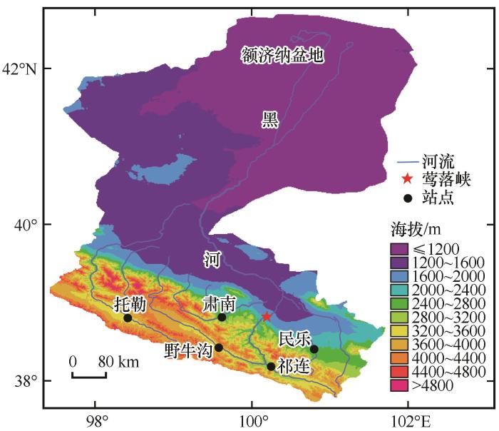
... 黑河发源于青海省的祁连山, 进入甘肃省的河西走廊, 最终到达内蒙古自治区额济纳旗东居延海和西居延海, 全长821 km.流域面积约13×104 km2.本文研究点(图1)集中在黑河上游(上游和中游以莺落峡为界), 海拔1 700 ~ 5 564 m, 寒冷阴湿, 多年平均气温-5 ~ 4 ℃, 年降水量在200 mm以上, 多集中在夏季, 局部高山带年降水可达600 ~ 700 mm, 年均融水量约4×10⁸ m3[18]. ...
... 表1中, 研究区δ18O值范围是: -33.3‰ ~ 9.7‰, δD值范围是: -264.9‰ ~ 67.5‰, 较赵良菊等[18]研究得出的黑河上游降水稳定同位素变化范围(δ18O: -24.5‰ ~ 3.2‰, δD: -172.6‰ ~ 33.5‰)略大, 但数据还是集中在该范围内(图2). ...
... 降水稳定同位素值夏高东低是由于研究区为内陆区, 季节变化明显[43].黑河上游大气水线方程的斜率和截距(δD=8.02δ18O+11.02)较整个黑河流域[17](δD=7.82δ18O+7.63)大, 这可能与黑河流域的中游平原和下游的山地戈壁[14]较上游的祁连山区干燥有关, 可以发现, 本文研究结果与相关研究在上游站点的大气水线(西水: δD=7.96δ18O+13.79[16], 野牛沟: δD=7.65δ18O+12.40[18], 祁连: δD=8.29δ18O+17.13[3])相差不大, 此外, 斜率和截距均略高于全球大气水线说明黑河上游整体上气候较为湿润, 受一定的海洋性水汽影响[40].Liu等[44]研究发现西北地区降水的温度效应明显, 降水量效应弱, 相关研究[17,43]均表明在研究区存在温度效应, 不存在降水量效应, 这主要是因为研究区夏季降水量较大, 但是温度较高使得降水蒸发强烈, 再加上局地蒸发水汽的混入, 使得夏季呈现出降水量大但降水同位素值也高的现象.而在冬季, 水汽主要来源于高纬度地区, 同位素贫化, 再加上温度低且降水多为固态, 蒸发弱, 所以降水量小但同位素值也小, 符合同位素经典理论, 即降水量效应在低纬度地区较明显, 中高纬度地区主要受温度效应控制[45]. ...
黑河源区水汽来源及地表径流组成的稳定同位素证据
4
2011
... 目前, 水汽来源分析方法主要有: HYSPLIT和FLEXPART模式[9-10]、 同位素分析法[11]和欧拉方法[12]等, 大都使用单一方法进行分析.关于黑河上游及其周边地区降水同位素和水汽来源已有不少研究[13-18], 但水汽来源鉴定方法较传统, 运用同位素和水汽来源方法综合研究典型降水事件也不多见.综上, 本文除对研究区降水同位素特征进行分析外, 重点在水汽来源方面, 将后向轨迹和水汽d-excess(d-excess=δD-8δ18O)数据结合起来, 使用潜在源贡献因子(potential source contribution function, PSCF)分析法定性分析了研究区夏季降水的潜在蒸发源区, 已有学者[19-20]利用类似方法进行了各自研究区的潜在蒸发源地的研究, 表明了此方法在水汽源地鉴定方面的适用性[21].此方法的优越性在于d-excess的影响因素较少, 蒸发形成的水汽d-excess值很高, 可以明显区别于水体的d-excess[22], 此外, PSCF的可视化分析结果, 便于理解和识别潜在蒸发源区, 对于理解区域水汽循环过程具有深刻意义. ...
... 黑河发源于青海省的祁连山, 进入甘肃省的河西走廊, 最终到达内蒙古自治区额济纳旗东居延海和西居延海, 全长821 km.流域面积约13×104 km2.本文研究点(图1)集中在黑河上游(上游和中游以莺落峡为界), 海拔1 700 ~ 5 564 m, 寒冷阴湿, 多年平均气温-5 ~ 4 ℃, 年降水量在200 mm以上, 多集中在夏季, 局部高山带年降水可达600 ~ 700 mm, 年均融水量约4×10⁸ m3[18]. ...
... 表1中, 研究区δ18O值范围是: -33.3‰ ~ 9.7‰, δD值范围是: -264.9‰ ~ 67.5‰, 较赵良菊等[18]研究得出的黑河上游降水稳定同位素变化范围(δ18O: -24.5‰ ~ 3.2‰, δD: -172.6‰ ~ 33.5‰)略大, 但数据还是集中在该范围内(图2). ...
... 降水稳定同位素值夏高东低是由于研究区为内陆区, 季节变化明显[43].黑河上游大气水线方程的斜率和截距(δD=8.02δ18O+11.02)较整个黑河流域[17](δD=7.82δ18O+7.63)大, 这可能与黑河流域的中游平原和下游的山地戈壁[14]较上游的祁连山区干燥有关, 可以发现, 本文研究结果与相关研究在上游站点的大气水线(西水: δD=7.96δ18O+13.79[16], 野牛沟: δD=7.65δ18O+12.40[18], 祁连: δD=8.29δ18O+17.13[3])相差不大, 此外, 斜率和截距均略高于全球大气水线说明黑河上游整体上气候较为湿润, 受一定的海洋性水汽影响[40].Liu等[44]研究发现西北地区降水的温度效应明显, 降水量效应弱, 相关研究[17,43]均表明在研究区存在温度效应, 不存在降水量效应, 这主要是因为研究区夏季降水量较大, 但是温度较高使得降水蒸发强烈, 再加上局地蒸发水汽的混入, 使得夏季呈现出降水量大但降水同位素值也高的现象.而在冬季, 水汽主要来源于高纬度地区, 同位素贫化, 再加上温度低且降水多为固态, 蒸发弱, 所以降水量小但同位素值也小, 符合同位素经典理论, 即降水量效应在低纬度地区较明显, 中高纬度地区主要受温度效应控制[45]. ...
Stable isotopic composition of atmospheric water vapor in Patras, Greece: a concentration weighted trajectory approach
1
2015
... 目前, 水汽来源分析方法主要有: HYSPLIT和FLEXPART模式[9-10]、 同位素分析法[11]和欧拉方法[12]等, 大都使用单一方法进行分析.关于黑河上游及其周边地区降水同位素和水汽来源已有不少研究[13-18], 但水汽来源鉴定方法较传统, 运用同位素和水汽来源方法综合研究典型降水事件也不多见.综上, 本文除对研究区降水同位素特征进行分析外, 重点在水汽来源方面, 将后向轨迹和水汽d-excess(d-excess=δD-8δ18O)数据结合起来, 使用潜在源贡献因子(potential source contribution function, PSCF)分析法定性分析了研究区夏季降水的潜在蒸发源区, 已有学者[19-20]利用类似方法进行了各自研究区的潜在蒸发源地的研究, 表明了此方法在水汽源地鉴定方面的适用性[21].此方法的优越性在于d-excess的影响因素较少, 蒸发形成的水汽d-excess值很高, 可以明显区别于水体的d-excess[22], 此外, PSCF的可视化分析结果, 便于理解和识别潜在蒸发源区, 对于理解区域水汽循环过程具有深刻意义. ...
Application of CWT method in identifying water vapor sources of summer precipitation in China
3
2018
... 目前, 水汽来源分析方法主要有: HYSPLIT和FLEXPART模式[9-10]、 同位素分析法[11]和欧拉方法[12]等, 大都使用单一方法进行分析.关于黑河上游及其周边地区降水同位素和水汽来源已有不少研究[13-18], 但水汽来源鉴定方法较传统, 运用同位素和水汽来源方法综合研究典型降水事件也不多见.综上, 本文除对研究区降水同位素特征进行分析外, 重点在水汽来源方面, 将后向轨迹和水汽d-excess(d-excess=δD-8δ18O)数据结合起来, 使用潜在源贡献因子(potential source contribution function, PSCF)分析法定性分析了研究区夏季降水的潜在蒸发源区, 已有学者[19-20]利用类似方法进行了各自研究区的潜在蒸发源地的研究, 表明了此方法在水汽源地鉴定方面的适用性[21].此方法的优越性在于d-excess的影响因素较少, 蒸发形成的水汽d-excess值很高, 可以明显区别于水体的d-excess[22], 此外, PSCF的可视化分析结果, 便于理解和识别潜在蒸发源区, 对于理解区域水汽循环过程具有深刻意义. ...
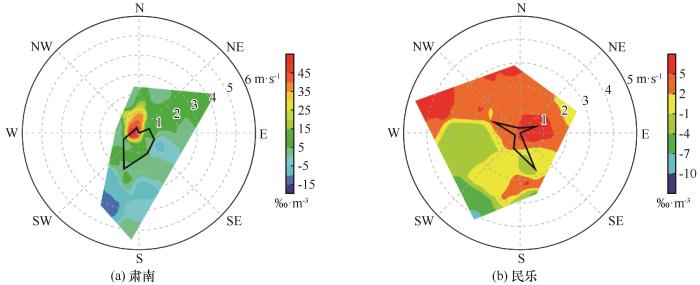
... 通过肃南夏季PSCF分析图[图10(a)]可以看出, 河西地区东部和西南部、 青海省西北部、 新疆东部均是PSCF分析的高值区, 部分研究[33-35]表明这些区域夏季高温干燥, 蒸发量大.值得注意的是青藏高原东南部也是一个高值区, 这是因为高原东南部作为一个“高湿区”[36], 在夏季蒸发旺盛, 高值概率在30%以上, 也是研究区的潜在蒸发源地, 这与已有研究结果相似[20].图10(b)显示, 民乐夏季PSCF值的高值区集中在研究点附近及河西地区东部, 高值概率在40%以上.图10(c)显示, 祁连夏季PSCF值的高值区集中在研究点周围的祁连山区、 河西地区东部及西南部、 青藏高原东南部, 已有研究表明[37-38], 上游的祁连山区在夏季蒸发强烈.图10(d)显示, 托勒夏季PSCF值的高值区集中在祁连山区、 新疆东部、 河西地区东部及西南部, 高值概率在40%以上. ...
... 姚檀栋等[46]将青藏高原分为三个区, 黑河上游位于西风区(35° N以北), 受西风主导, 从本文研究结果看, 研究区全年受西风水汽影响显著, 夏季水汽来源较复杂[16], 会受一定程度的季风水汽影响[3], 这与前人研究结果一致[46-49].研究区夏季降水受局地蒸发水汽影响较大[43,50], 本文研究得出的潜在蒸发源地集中在一些蒸发量较大或相对湿度大的地区, 且均位于水汽运移路径上, 局地蒸发水汽随气流被输送到研究区[20].d-excess在潜在蒸发源地的鉴别及典型降水事件中的应用反映出了d-excess在鉴别水汽来源问题上的优越性[51]. ...
CWT方法在中国夏季降水水汽来源识别中的应用
3
2018
... 目前, 水汽来源分析方法主要有: HYSPLIT和FLEXPART模式[9-10]、 同位素分析法[11]和欧拉方法[12]等, 大都使用单一方法进行分析.关于黑河上游及其周边地区降水同位素和水汽来源已有不少研究[13-18], 但水汽来源鉴定方法较传统, 运用同位素和水汽来源方法综合研究典型降水事件也不多见.综上, 本文除对研究区降水同位素特征进行分析外, 重点在水汽来源方面, 将后向轨迹和水汽d-excess(d-excess=δD-8δ18O)数据结合起来, 使用潜在源贡献因子(potential source contribution function, PSCF)分析法定性分析了研究区夏季降水的潜在蒸发源区, 已有学者[19-20]利用类似方法进行了各自研究区的潜在蒸发源地的研究, 表明了此方法在水汽源地鉴定方面的适用性[21].此方法的优越性在于d-excess的影响因素较少, 蒸发形成的水汽d-excess值很高, 可以明显区别于水体的d-excess[22], 此外, PSCF的可视化分析结果, 便于理解和识别潜在蒸发源区, 对于理解区域水汽循环过程具有深刻意义. ...
... 通过肃南夏季PSCF分析图[图10(a)]可以看出, 河西地区东部和西南部、 青海省西北部、 新疆东部均是PSCF分析的高值区, 部分研究[33-35]表明这些区域夏季高温干燥, 蒸发量大.值得注意的是青藏高原东南部也是一个高值区, 这是因为高原东南部作为一个“高湿区”[36], 在夏季蒸发旺盛, 高值概率在30%以上, 也是研究区的潜在蒸发源地, 这与已有研究结果相似[20].图10(b)显示, 民乐夏季PSCF值的高值区集中在研究点附近及河西地区东部, 高值概率在40%以上.图10(c)显示, 祁连夏季PSCF值的高值区集中在研究点周围的祁连山区、 河西地区东部及西南部、 青藏高原东南部, 已有研究表明[37-38], 上游的祁连山区在夏季蒸发强烈.图10(d)显示, 托勒夏季PSCF值的高值区集中在祁连山区、 新疆东部、 河西地区东部及西南部, 高值概率在40%以上. ...
... 姚檀栋等[46]将青藏高原分为三个区, 黑河上游位于西风区(35° N以北), 受西风主导, 从本文研究结果看, 研究区全年受西风水汽影响显著, 夏季水汽来源较复杂[16], 会受一定程度的季风水汽影响[3], 这与前人研究结果一致[46-49].研究区夏季降水受局地蒸发水汽影响较大[43,50], 本文研究得出的潜在蒸发源地集中在一些蒸发量较大或相对湿度大的地区, 且均位于水汽运移路径上, 局地蒸发水汽随气流被输送到研究区[20].d-excess在潜在蒸发源地的鉴别及典型降水事件中的应用反映出了d-excess在鉴别水汽来源问题上的优越性[51]. ...
Isotopic characteristics of water vapor and its sources during day and night along the Heihe River in summer
1
2020
... 目前, 水汽来源分析方法主要有: HYSPLIT和FLEXPART模式[9-10]、 同位素分析法[11]和欧拉方法[12]等, 大都使用单一方法进行分析.关于黑河上游及其周边地区降水同位素和水汽来源已有不少研究[13-18], 但水汽来源鉴定方法较传统, 运用同位素和水汽来源方法综合研究典型降水事件也不多见.综上, 本文除对研究区降水同位素特征进行分析外, 重点在水汽来源方面, 将后向轨迹和水汽d-excess(d-excess=δD-8δ18O)数据结合起来, 使用潜在源贡献因子(potential source contribution function, PSCF)分析法定性分析了研究区夏季降水的潜在蒸发源区, 已有学者[19-20]利用类似方法进行了各自研究区的潜在蒸发源地的研究, 表明了此方法在水汽源地鉴定方面的适用性[21].此方法的优越性在于d-excess的影响因素较少, 蒸发形成的水汽d-excess值很高, 可以明显区别于水体的d-excess[22], 此外, PSCF的可视化分析结果, 便于理解和识别潜在蒸发源区, 对于理解区域水汽循环过程具有深刻意义. ...
黑河中游夏季昼夜水汽同位素特征及水汽来源分析
1
2020
... 目前, 水汽来源分析方法主要有: HYSPLIT和FLEXPART模式[9-10]、 同位素分析法[11]和欧拉方法[12]等, 大都使用单一方法进行分析.关于黑河上游及其周边地区降水同位素和水汽来源已有不少研究[13-18], 但水汽来源鉴定方法较传统, 运用同位素和水汽来源方法综合研究典型降水事件也不多见.综上, 本文除对研究区降水同位素特征进行分析外, 重点在水汽来源方面, 将后向轨迹和水汽d-excess(d-excess=δD-8δ18O)数据结合起来, 使用潜在源贡献因子(potential source contribution function, PSCF)分析法定性分析了研究区夏季降水的潜在蒸发源区, 已有学者[19-20]利用类似方法进行了各自研究区的潜在蒸发源地的研究, 表明了此方法在水汽源地鉴定方面的适用性[21].此方法的优越性在于d-excess的影响因素较少, 蒸发形成的水汽d-excess值很高, 可以明显区别于水体的d-excess[22], 此外, PSCF的可视化分析结果, 便于理解和识别潜在蒸发源区, 对于理解区域水汽循环过程具有深刻意义. ...
Deuterium excess in precipitation of Alpine regions: moisture recycling
2
2008
... 目前, 水汽来源分析方法主要有: HYSPLIT和FLEXPART模式[9-10]、 同位素分析法[11]和欧拉方法[12]等, 大都使用单一方法进行分析.关于黑河上游及其周边地区降水同位素和水汽来源已有不少研究[13-18], 但水汽来源鉴定方法较传统, 运用同位素和水汽来源方法综合研究典型降水事件也不多见.综上, 本文除对研究区降水同位素特征进行分析外, 重点在水汽来源方面, 将后向轨迹和水汽d-excess(d-excess=δD-8δ18O)数据结合起来, 使用潜在源贡献因子(potential source contribution function, PSCF)分析法定性分析了研究区夏季降水的潜在蒸发源区, 已有学者[19-20]利用类似方法进行了各自研究区的潜在蒸发源地的研究, 表明了此方法在水汽源地鉴定方面的适用性[21].此方法的优越性在于d-excess的影响因素较少, 蒸发形成的水汽d-excess值很高, 可以明显区别于水体的d-excess[22], 此外, PSCF的可视化分析结果, 便于理解和识别潜在蒸发源区, 对于理解区域水汽循环过程具有深刻意义. ...
... 式中: α18w-v 和α2w-v 是水和水蒸气氢氧同位素之间的平衡分馏系数, 和温度T(K)存在以下关系[6,22,25]: ...
1
1997
... 在黑河上游均匀选取肃南、 民乐、 野牛沟、 祁连和托勒五个站点作为研究站点.降水发生时, 用容器快速采集水样, 降低蒸发带来的数据误差.对于液态水, 用塑料水样瓶密封保存; 固态水样(降雪)需要装入干净的塑料袋内, 自然融化后装入水样瓶中密封, 并记录降水发生时的基本气象要素.降水δ18O、 δD日数据时段为2015年8月 - 2016年8月, 野牛沟数据时段为2015年8月 - 2016年7月.水样实验在西北师范大学地理与环境科学学院稳定同位素实验室完成, δD和δ18O值的测试误差分别不超过±1‰和±0.3‰.后向轨迹、 PSCF使用的是由美国国家环境预报中心的GDAS气象数据, 空间分辨率为1°×1°.风速、 风向数据来自国家气象信息中心(http://data.cma.cn/).大气可降水量、 水汽通量的计算参照相关文献[23], 春、 夏、 秋、 冬的水汽通量采用欧洲中期天气预报中心的ERA-Interim数据, 空间分辨率为0.75°×0.75°, 为了与后向轨迹高度相对应, 根据后向轨迹起始高度和气压高度对照表对700、 650、 600、 550、 500 hPa气压高度层进行分析.暴雨水汽通量使用分辨率为2.5°×2.5°的NCEP气象数据, 气压高度层是地面至500 hPa.降水水汽同位素数据根据公式[24]计算得到: ...
A water isotope approach to assessing moisture recycling in the island-based precipitation of Taiwan: A case study in the western Pacific
1
2011
... 在黑河上游均匀选取肃南、 民乐、 野牛沟、 祁连和托勒五个站点作为研究站点.降水发生时, 用容器快速采集水样, 降低蒸发带来的数据误差.对于液态水, 用塑料水样瓶密封保存; 固态水样(降雪)需要装入干净的塑料袋内, 自然融化后装入水样瓶中密封, 并记录降水发生时的基本气象要素.降水δ18O、 δD日数据时段为2015年8月 - 2016年8月, 野牛沟数据时段为2015年8月 - 2016年7月.水样实验在西北师范大学地理与环境科学学院稳定同位素实验室完成, δD和δ18O值的测试误差分别不超过±1‰和±0.3‰.后向轨迹、 PSCF使用的是由美国国家环境预报中心的GDAS气象数据, 空间分辨率为1°×1°.风速、 风向数据来自国家气象信息中心(http://data.cma.cn/).大气可降水量、 水汽通量的计算参照相关文献[23], 春、 夏、 秋、 冬的水汽通量采用欧洲中期天气预报中心的ERA-Interim数据, 空间分辨率为0.75°×0.75°, 为了与后向轨迹高度相对应, 根据后向轨迹起始高度和气压高度对照表对700、 650、 600、 550、 500 hPa气压高度层进行分析.暴雨水汽通量使用分辨率为2.5°×2.5°的NCEP气象数据, 气压高度层是地面至500 hPa.降水水汽同位素数据根据公式[24]计算得到: ...
Data of geochemistry: compilation of stable isotope fractionation factors of geochemical interest
1
1977
... 式中: α18w-v 和α2w-v 是水和水蒸气氢氧同位素之间的平衡分馏系数, 和温度T(K)存在以下关系[6,22,25]: ...
TrajStat: GIS-based software that uses various trajectory statistical analysis methods to identify potential sources from long-term air pollution measurement data
1
2009
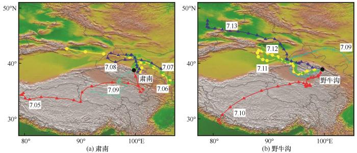
... 研究使用轨迹计算利用了HYSPLIT模式计算模块的TrajStat软件[26-27].根据每对轨迹组合的空间相异度(SPVAR)、 总空间相异度(TSV)对气团轨迹进行聚类[28], TSV等于所有聚类SPVAR的总和.本文轨迹聚类采用角度距离算法[29], 得到各研究点主要的水汽来源方向.SPVAR计算如式(6)所示. ...
An overview of the HYSPLIT_4 modelling system for trajectories
1
1998
... 研究使用轨迹计算利用了HYSPLIT模式计算模块的TrajStat软件[26-27].根据每对轨迹组合的空间相异度(SPVAR)、 总空间相异度(TSV)对气团轨迹进行聚类[28], TSV等于所有聚类SPVAR的总和.本文轨迹聚类采用角度距离算法[29], 得到各研究点主要的水汽来源方向.SPVAR计算如式(6)所示. ...
Impact of the air mass trajectories on PM2.5 concentrations and distribution in the Yangtze River Delta in December 2015
1
2016
... 研究使用轨迹计算利用了HYSPLIT模式计算模块的TrajStat软件[26-27].根据每对轨迹组合的空间相异度(SPVAR)、 总空间相异度(TSV)对气团轨迹进行聚类[28], TSV等于所有聚类SPVAR的总和.本文轨迹聚类采用角度距离算法[29], 得到各研究点主要的水汽来源方向.SPVAR计算如式(6)所示. ...
2015年12月气流轨迹对长三角区域细颗粒物浓度和分布的影响
1
2016
... 研究使用轨迹计算利用了HYSPLIT模式计算模块的TrajStat软件[26-27].根据每对轨迹组合的空间相异度(SPVAR)、 总空间相异度(TSV)对气团轨迹进行聚类[28], TSV等于所有聚类SPVAR的总和.本文轨迹聚类采用角度距离算法[29], 得到各研究点主要的水汽来源方向.SPVAR计算如式(6)所示. ...
Identification of transportation pathways and sources of SO
1
2016
... 研究使用轨迹计算利用了HYSPLIT模式计算模块的TrajStat软件[26-27].根据每对轨迹组合的空间相异度(SPVAR)、 总空间相异度(TSV)对气团轨迹进行聚类[28], TSV等于所有聚类SPVAR的总和.本文轨迹聚类采用角度距离算法[29], 得到各研究点主要的水汽来源方向.SPVAR计算如式(6)所示. ...
天津团泊洼地区SO2和NO2传输轨迹及来源识别
1
2016
... 研究使用轨迹计算利用了HYSPLIT模式计算模块的TrajStat软件[26-27].根据每对轨迹组合的空间相异度(SPVAR)、 总空间相异度(TSV)对气团轨迹进行聚类[28], TSV等于所有聚类SPVAR的总和.本文轨迹聚类采用角度距离算法[29], 得到各研究点主要的水汽来源方向.SPVAR计算如式(6)所示. ...
Study of source distribution and transportation characteristics of PM2.5 in Shanghai using back ward trajectory model
1
2014
... 式中: Dij 为第i条轨迹中第j个小时的停留点到平均轨迹相应点的距离; t为轨迹时长; x为该聚类中的轨迹条数[30]. ...
利用后向轨迹模式研究上海市PM2.5来源分布及传输特征
1
2014
... 式中: Dij 为第i条轨迹中第j个小时的停留点到平均轨迹相应点的距离; t为轨迹时长; x为该聚类中的轨迹条数[30]. ...
A study of the sources of acid precipitation in Ontario, Canada
2
1989
... PSCF是一种基于条件概率函数来识别潜在污染源的方法[31], 通过计算污染轨迹与指定区域所有轨迹停留时间的比值来表示网格对研究区污染的贡献程度, 其定义经过某一区域的所有轨迹到达研究点所对应的某要素值(本文指水汽d-excess浓度值)超过设定阈值(本文指水汽d-excess浓度平均值, 设定的依据参考相关文献[32]), 则认为该轨迹水汽d-excess值较高, 高PSCF值所对应网格组成的区域就是研究点的潜在蒸发源区.随着网格与采样点的距离变大, PSCF的误差会增大, 当nij减小时, 不确定性又会增加, 因此, 引入权重函数公式(8), W(nij)函数的确定参考Zeng等[31]的研究结果. ...
... [31]的研究结果. ...
Aerosol number concentration properties and potential sources areas transporting to the top of mountain Huangshan in summer
1
2014
... PSCF是一种基于条件概率函数来识别潜在污染源的方法[31], 通过计算污染轨迹与指定区域所有轨迹停留时间的比值来表示网格对研究区污染的贡献程度, 其定义经过某一区域的所有轨迹到达研究点所对应的某要素值(本文指水汽d-excess浓度值)超过设定阈值(本文指水汽d-excess浓度平均值, 设定的依据参考相关文献[32]), 则认为该轨迹水汽d-excess值较高, 高PSCF值所对应网格组成的区域就是研究点的潜在蒸发源区.随着网格与采样点的距离变大, PSCF的误差会增大, 当nij减小时, 不确定性又会增加, 因此, 引入权重函数公式(8), W(nij)函数的确定参考Zeng等[31]的研究结果. ...
黄山顶夏季气溶胶数浓度特征及其输送潜在源区
1
2014
... PSCF是一种基于条件概率函数来识别潜在污染源的方法[31], 通过计算污染轨迹与指定区域所有轨迹停留时间的比值来表示网格对研究区污染的贡献程度, 其定义经过某一区域的所有轨迹到达研究点所对应的某要素值(本文指水汽d-excess浓度值)超过设定阈值(本文指水汽d-excess浓度平均值, 设定的依据参考相关文献[32]), 则认为该轨迹水汽d-excess值较高, 高PSCF值所对应网格组成的区域就是研究点的潜在蒸发源区.随着网格与采样点的距离变大, PSCF的误差会增大, 当nij减小时, 不确定性又会增加, 因此, 引入权重函数公式(8), W(nij)函数的确定参考Zeng等[31]的研究结果. ...
Temporal and spatial change of the potential evaporation over Qilian mountains and Hexi corridor from 1960 to 2006
1
2009
... 通过肃南夏季PSCF分析图[图10(a)]可以看出, 河西地区东部和西南部、 青海省西北部、 新疆东部均是PSCF分析的高值区, 部分研究[33-35]表明这些区域夏季高温干燥, 蒸发量大.值得注意的是青藏高原东南部也是一个高值区, 这是因为高原东南部作为一个“高湿区”[36], 在夏季蒸发旺盛, 高值概率在30%以上, 也是研究区的潜在蒸发源地, 这与已有研究结果相似[20].图10(b)显示, 民乐夏季PSCF值的高值区集中在研究点附近及河西地区东部, 高值概率在40%以上.图10(c)显示, 祁连夏季PSCF值的高值区集中在研究点周围的祁连山区、 河西地区东部及西南部、 青藏高原东南部, 已有研究表明[37-38], 上游的祁连山区在夏季蒸发强烈.图10(d)显示, 托勒夏季PSCF值的高值区集中在祁连山区、 新疆东部、 河西地区东部及西南部, 高值概率在40%以上. ...
祁连山及河西走廊潜在蒸发量的时空变化
1
2009
... 通过肃南夏季PSCF分析图[图10(a)]可以看出, 河西地区东部和西南部、 青海省西北部、 新疆东部均是PSCF分析的高值区, 部分研究[33-35]表明这些区域夏季高温干燥, 蒸发量大.值得注意的是青藏高原东南部也是一个高值区, 这是因为高原东南部作为一个“高湿区”[36], 在夏季蒸发旺盛, 高值概率在30%以上, 也是研究区的潜在蒸发源地, 这与已有研究结果相似[20].图10(b)显示, 民乐夏季PSCF值的高值区集中在研究点附近及河西地区东部, 高值概率在40%以上.图10(c)显示, 祁连夏季PSCF值的高值区集中在研究点周围的祁连山区、 河西地区东部及西南部、 青藏高原东南部, 已有研究表明[37-38], 上游的祁连山区在夏季蒸发强烈.图10(d)显示, 托勒夏季PSCF值的高值区集中在祁连山区、 新疆东部、 河西地区东部及西南部, 高值概率在40%以上. ...
Spatial variability of main climatic resources in northwest arid area
0
2017
西北旱区主要气候资源的空间变异性研究
0
2017
The Temporal and spatial distribution of surface dry-wet conditions over northwestern China in recent 50 years
1
2004
... 通过肃南夏季PSCF分析图[图10(a)]可以看出, 河西地区东部和西南部、 青海省西北部、 新疆东部均是PSCF分析的高值区, 部分研究[33-35]表明这些区域夏季高温干燥, 蒸发量大.值得注意的是青藏高原东南部也是一个高值区, 这是因为高原东南部作为一个“高湿区”[36], 在夏季蒸发旺盛, 高值概率在30%以上, 也是研究区的潜在蒸发源地, 这与已有研究结果相似[20].图10(b)显示, 民乐夏季PSCF值的高值区集中在研究点附近及河西地区东部, 高值概率在40%以上.图10(c)显示, 祁连夏季PSCF值的高值区集中在研究点周围的祁连山区、 河西地区东部及西南部、 青藏高原东南部, 已有研究表明[37-38], 上游的祁连山区在夏季蒸发强烈.图10(d)显示, 托勒夏季PSCF值的高值区集中在祁连山区、 新疆东部、 河西地区东部及西南部, 高值概率在40%以上. ...
近50年来中国西北地区干湿状况时空分布
1
2004
... 通过肃南夏季PSCF分析图[图10(a)]可以看出, 河西地区东部和西南部、 青海省西北部、 新疆东部均是PSCF分析的高值区, 部分研究[33-35]表明这些区域夏季高温干燥, 蒸发量大.值得注意的是青藏高原东南部也是一个高值区, 这是因为高原东南部作为一个“高湿区”[36], 在夏季蒸发旺盛, 高值概率在30%以上, 也是研究区的潜在蒸发源地, 这与已有研究结果相似[20].图10(b)显示, 民乐夏季PSCF值的高值区集中在研究点附近及河西地区东部, 高值概率在40%以上.图10(c)显示, 祁连夏季PSCF值的高值区集中在研究点周围的祁连山区、 河西地区东部及西南部、 青藏高原东南部, 已有研究表明[37-38], 上游的祁连山区在夏季蒸发强烈.图10(d)显示, 托勒夏季PSCF值的高值区集中在祁连山区、 新疆东部、 河西地区东部及西南部, 高值概率在40%以上. ...
Characteristics of the moist pool and its moisture transports over Qinghai-Xizang Plateau in summer half year
1
2009
... 通过肃南夏季PSCF分析图[图10(a)]可以看出, 河西地区东部和西南部、 青海省西北部、 新疆东部均是PSCF分析的高值区, 部分研究[33-35]表明这些区域夏季高温干燥, 蒸发量大.值得注意的是青藏高原东南部也是一个高值区, 这是因为高原东南部作为一个“高湿区”[36], 在夏季蒸发旺盛, 高值概率在30%以上, 也是研究区的潜在蒸发源地, 这与已有研究结果相似[20].图10(b)显示, 民乐夏季PSCF值的高值区集中在研究点附近及河西地区东部, 高值概率在40%以上.图10(c)显示, 祁连夏季PSCF值的高值区集中在研究点周围的祁连山区、 河西地区东部及西南部、 青藏高原东南部, 已有研究表明[37-38], 上游的祁连山区在夏季蒸发强烈.图10(d)显示, 托勒夏季PSCF值的高值区集中在祁连山区、 新疆东部、 河西地区东部及西南部, 高值概率在40%以上. ...
夏半年青藏高原“湿池”的水汽分布及水汽输送特征
1
2009
... 通过肃南夏季PSCF分析图[图10(a)]可以看出, 河西地区东部和西南部、 青海省西北部、 新疆东部均是PSCF分析的高值区, 部分研究[33-35]表明这些区域夏季高温干燥, 蒸发量大.值得注意的是青藏高原东南部也是一个高值区, 这是因为高原东南部作为一个“高湿区”[36], 在夏季蒸发旺盛, 高值概率在30%以上, 也是研究区的潜在蒸发源地, 这与已有研究结果相似[20].图10(b)显示, 民乐夏季PSCF值的高值区集中在研究点附近及河西地区东部, 高值概率在40%以上.图10(c)显示, 祁连夏季PSCF值的高值区集中在研究点周围的祁连山区、 河西地区东部及西南部、 青藏高原东南部, 已有研究表明[37-38], 上游的祁连山区在夏季蒸发强烈.图10(d)显示, 托勒夏季PSCF值的高值区集中在祁连山区、 新疆东部、 河西地区东部及西南部, 高值概率在40%以上. ...
Application of remote sensing technology to estimate river basin evapotranspiration
1
2009
... 通过肃南夏季PSCF分析图[图10(a)]可以看出, 河西地区东部和西南部、 青海省西北部、 新疆东部均是PSCF分析的高值区, 部分研究[33-35]表明这些区域夏季高温干燥, 蒸发量大.值得注意的是青藏高原东南部也是一个高值区, 这是因为高原东南部作为一个“高湿区”[36], 在夏季蒸发旺盛, 高值概率在30%以上, 也是研究区的潜在蒸发源地, 这与已有研究结果相似[20].图10(b)显示, 民乐夏季PSCF值的高值区集中在研究点附近及河西地区东部, 高值概率在40%以上.图10(c)显示, 祁连夏季PSCF值的高值区集中在研究点周围的祁连山区、 河西地区东部及西南部、 青藏高原东南部, 已有研究表明[37-38], 上游的祁连山区在夏季蒸发强烈.图10(d)显示, 托勒夏季PSCF值的高值区集中在祁连山区、 新疆东部、 河西地区东部及西南部, 高值概率在40%以上. ...
应用遥感技术反演流域尺度的蒸散发
1
2009
... 通过肃南夏季PSCF分析图[图10(a)]可以看出, 河西地区东部和西南部、 青海省西北部、 新疆东部均是PSCF分析的高值区, 部分研究[33-35]表明这些区域夏季高温干燥, 蒸发量大.值得注意的是青藏高原东南部也是一个高值区, 这是因为高原东南部作为一个“高湿区”[36], 在夏季蒸发旺盛, 高值概率在30%以上, 也是研究区的潜在蒸发源地, 这与已有研究结果相似[20].图10(b)显示, 民乐夏季PSCF值的高值区集中在研究点附近及河西地区东部, 高值概率在40%以上.图10(c)显示, 祁连夏季PSCF值的高值区集中在研究点周围的祁连山区、 河西地区东部及西南部、 青藏高原东南部, 已有研究表明[37-38], 上游的祁连山区在夏季蒸发强烈.图10(d)显示, 托勒夏季PSCF值的高值区集中在祁连山区、 新疆东部、 河西地区东部及西南部, 高值概率在40%以上. ...
Simulation of potential evapotranspiration in Heihe River basin based on HASM
1
2017
... 通过肃南夏季PSCF分析图[图10(a)]可以看出, 河西地区东部和西南部、 青海省西北部、 新疆东部均是PSCF分析的高值区, 部分研究[33-35]表明这些区域夏季高温干燥, 蒸发量大.值得注意的是青藏高原东南部也是一个高值区, 这是因为高原东南部作为一个“高湿区”[36], 在夏季蒸发旺盛, 高值概率在30%以上, 也是研究区的潜在蒸发源地, 这与已有研究结果相似[20].图10(b)显示, 民乐夏季PSCF值的高值区集中在研究点附近及河西地区东部, 高值概率在40%以上.图10(c)显示, 祁连夏季PSCF值的高值区集中在研究点周围的祁连山区、 河西地区东部及西南部、 青藏高原东南部, 已有研究表明[37-38], 上游的祁连山区在夏季蒸发强烈.图10(d)显示, 托勒夏季PSCF值的高值区集中在祁连山区、 新疆东部、 河西地区东部及西南部, 高值概率在40%以上. ...
基于HASM方法的黑河流域潜在蒸发量的模拟
1
2017
... 通过肃南夏季PSCF分析图[图10(a)]可以看出, 河西地区东部和西南部、 青海省西北部、 新疆东部均是PSCF分析的高值区, 部分研究[33-35]表明这些区域夏季高温干燥, 蒸发量大.值得注意的是青藏高原东南部也是一个高值区, 这是因为高原东南部作为一个“高湿区”[36], 在夏季蒸发旺盛, 高值概率在30%以上, 也是研究区的潜在蒸发源地, 这与已有研究结果相似[20].图10(b)显示, 民乐夏季PSCF值的高值区集中在研究点附近及河西地区东部, 高值概率在40%以上.图10(c)显示, 祁连夏季PSCF值的高值区集中在研究点周围的祁连山区、 河西地区东部及西南部、 青藏高原东南部, 已有研究表明[37-38], 上游的祁连山区在夏季蒸发强烈.图10(d)显示, 托勒夏季PSCF值的高值区集中在祁连山区、 新疆东部、 河西地区东部及西南部, 高值概率在40%以上. ...
1
1987
... 根据黑河上游降水的气候特征和实际情况, 将研究区的降水量级标准规定为: 0 ~ 5 mm为小雨, 5 ~ 10 mm为中雨, 10 ~ 20 mm为大雨, 大于20 mm为暴雨, 大于40 mm为大暴雨[39]. ...
1
1987
... 根据黑河上游降水的气候特征和实际情况, 将研究区的降水量级标准规定为: 0 ~ 5 mm为小雨, 5 ~ 10 mm为中雨, 10 ~ 20 mm为大雨, 大于20 mm为暴雨, 大于40 mm为大暴雨[39]. ...
Characteristics of stable isotopes in precipitation and their moisture sources in Mengzi region,southern Yunnan
2
2016
... 本研究统计了8次暴雨以上的强降水事件的相关气象参数和同位素值(表5).整体来看, 8次降水事件温度相差较小, 相对湿度较高.δ18O、 δD的均值分别为-8.00‰、 -46.99‰, 同位素值较贫化, 这与降水水汽可能来源于海洋, 重同位素沿途被冲刷严重有关, 此外, d-excess值较高说明云下二次蒸发弱[40]. ...
... 降水稳定同位素值夏高东低是由于研究区为内陆区, 季节变化明显[43].黑河上游大气水线方程的斜率和截距(δD=8.02δ18O+11.02)较整个黑河流域[17](δD=7.82δ18O+7.63)大, 这可能与黑河流域的中游平原和下游的山地戈壁[14]较上游的祁连山区干燥有关, 可以发现, 本文研究结果与相关研究在上游站点的大气水线(西水: δD=7.96δ18O+13.79[16], 野牛沟: δD=7.65δ18O+12.40[18], 祁连: δD=8.29δ18O+17.13[3])相差不大, 此外, 斜率和截距均略高于全球大气水线说明黑河上游整体上气候较为湿润, 受一定的海洋性水汽影响[40].Liu等[44]研究发现西北地区降水的温度效应明显, 降水量效应弱, 相关研究[17,43]均表明在研究区存在温度效应, 不存在降水量效应, 这主要是因为研究区夏季降水量较大, 但是温度较高使得降水蒸发强烈, 再加上局地蒸发水汽的混入, 使得夏季呈现出降水量大但降水同位素值也高的现象.而在冬季, 水汽主要来源于高纬度地区, 同位素贫化, 再加上温度低且降水多为固态, 蒸发弱, 所以降水量小但同位素值也小, 符合同位素经典理论, 即降水量效应在低纬度地区较明显, 中高纬度地区主要受温度效应控制[45]. ...
滇南蒙自地区降水稳定同位素特征及其水汽来源
2
2016
... 本研究统计了8次暴雨以上的强降水事件的相关气象参数和同位素值(表5).整体来看, 8次降水事件温度相差较小, 相对湿度较高.δ18O、 δD的均值分别为-8.00‰、 -46.99‰, 同位素值较贫化, 这与降水水汽可能来源于海洋, 重同位素沿途被冲刷严重有关, 此外, d-excess值较高说明云下二次蒸发弱[40]. ...
... 降水稳定同位素值夏高东低是由于研究区为内陆区, 季节变化明显[43].黑河上游大气水线方程的斜率和截距(δD=8.02δ18O+11.02)较整个黑河流域[17](δD=7.82δ18O+7.63)大, 这可能与黑河流域的中游平原和下游的山地戈壁[14]较上游的祁连山区干燥有关, 可以发现, 本文研究结果与相关研究在上游站点的大气水线(西水: δD=7.96δ18O+13.79[16], 野牛沟: δD=7.65δ18O+12.40[18], 祁连: δD=8.29δ18O+17.13[3])相差不大, 此外, 斜率和截距均略高于全球大气水线说明黑河上游整体上气候较为湿润, 受一定的海洋性水汽影响[40].Liu等[44]研究发现西北地区降水的温度效应明显, 降水量效应弱, 相关研究[17,43]均表明在研究区存在温度效应, 不存在降水量效应, 这主要是因为研究区夏季降水量较大, 但是温度较高使得降水蒸发强烈, 再加上局地蒸发水汽的混入, 使得夏季呈现出降水量大但降水同位素值也高的现象.而在冬季, 水汽主要来源于高纬度地区, 同位素贫化, 再加上温度低且降水多为固态, 蒸发弱, 所以降水量小但同位素值也小, 符合同位素经典理论, 即降水量效应在低纬度地区较明显, 中高纬度地区主要受温度效应控制[45]. ...
Simulations of stable isotopic variations in precipitation and comparison with measured values in Yunnan Province, China
1
2012
... 8场强降水的大气水线方程为: δD=7.97δ18O+16.726, 斜率接近于全球大气水线的斜率, 截距较全球大气水线的斜率大, 说明强降水过程空气湿度较大, 云下二次蒸发弱[41]. ...
云南降水中稳定同位素变化的模拟和比较
1
2012
... 8场强降水的大气水线方程为: δD=7.97δ18O+16.726, 斜率接近于全球大气水线的斜率, 截距较全球大气水线的斜率大, 说明强降水过程空气湿度较大, 云下二次蒸发弱[41]. ...
Mechanism analysis of the plateau vortex triggered rainstorm in Hexi Corridor
1
2014
... 综上可以发现, 暴雨发生时水汽来源都比较复杂, 与前人研究结果吻合[42].d-excess值与水汽来源关系密切, 东南季风水汽d-excess值较小, 北方和西风水汽d-excess值较大. ...
一次引发河西走廊大暴雨的高原低涡的机制分析
1
2014
... 综上可以发现, 暴雨发生时水汽来源都比较复杂, 与前人研究结果吻合[42].d-excess值与水汽来源关系密切, 东南季风水汽d-excess值较小, 北方和西风水汽d-excess值较大. ...
Oxygen and hydrogen isotopes in precipitation in Heihe River basin, China
3
2009
... 降水稳定同位素值夏高东低是由于研究区为内陆区, 季节变化明显[43].黑河上游大气水线方程的斜率和截距(δD=8.02δ18O+11.02)较整个黑河流域[17](δD=7.82δ18O+7.63)大, 这可能与黑河流域的中游平原和下游的山地戈壁[14]较上游的祁连山区干燥有关, 可以发现, 本文研究结果与相关研究在上游站点的大气水线(西水: δD=7.96δ18O+13.79[16], 野牛沟: δD=7.65δ18O+12.40[18], 祁连: δD=8.29δ18O+17.13[3])相差不大, 此外, 斜率和截距均略高于全球大气水线说明黑河上游整体上气候较为湿润, 受一定的海洋性水汽影响[40].Liu等[44]研究发现西北地区降水的温度效应明显, 降水量效应弱, 相关研究[17,43]均表明在研究区存在温度效应, 不存在降水量效应, 这主要是因为研究区夏季降水量较大, 但是温度较高使得降水蒸发强烈, 再加上局地蒸发水汽的混入, 使得夏季呈现出降水量大但降水同位素值也高的现象.而在冬季, 水汽主要来源于高纬度地区, 同位素贫化, 再加上温度低且降水多为固态, 蒸发弱, 所以降水量小但同位素值也小, 符合同位素经典理论, 即降水量效应在低纬度地区较明显, 中高纬度地区主要受温度效应控制[45]. ...
... ,43]均表明在研究区存在温度效应, 不存在降水量效应, 这主要是因为研究区夏季降水量较大, 但是温度较高使得降水蒸发强烈, 再加上局地蒸发水汽的混入, 使得夏季呈现出降水量大但降水同位素值也高的现象.而在冬季, 水汽主要来源于高纬度地区, 同位素贫化, 再加上温度低且降水多为固态, 蒸发弱, 所以降水量小但同位素值也小, 符合同位素经典理论, 即降水量效应在低纬度地区较明显, 中高纬度地区主要受温度效应控制[45]. ...
... 姚檀栋等[46]将青藏高原分为三个区, 黑河上游位于西风区(35° N以北), 受西风主导, 从本文研究结果看, 研究区全年受西风水汽影响显著, 夏季水汽来源较复杂[16], 会受一定程度的季风水汽影响[3], 这与前人研究结果一致[46-49].研究区夏季降水受局地蒸发水汽影响较大[43,50], 本文研究得出的潜在蒸发源地集中在一些蒸发量较大或相对湿度大的地区, 且均位于水汽运移路径上, 局地蒸发水汽随气流被输送到研究区[20].d-excess在潜在蒸发源地的鉴别及典型降水事件中的应用反映出了d-excess在鉴别水汽来源问题上的优越性[51]. ...
黑河流域中上游地区降水δ 18O变化特征
3
2007
... 降水稳定同位素值夏高东低是由于研究区为内陆区, 季节变化明显[43].黑河上游大气水线方程的斜率和截距(δD=8.02δ18O+11.02)较整个黑河流域[17](δD=7.82δ18O+7.63)大, 这可能与黑河流域的中游平原和下游的山地戈壁[14]较上游的祁连山区干燥有关, 可以发现, 本文研究结果与相关研究在上游站点的大气水线(西水: δD=7.96δ18O+13.79[16], 野牛沟: δD=7.65δ18O+12.40[18], 祁连: δD=8.29δ18O+17.13[3])相差不大, 此外, 斜率和截距均略高于全球大气水线说明黑河上游整体上气候较为湿润, 受一定的海洋性水汽影响[40].Liu等[44]研究发现西北地区降水的温度效应明显, 降水量效应弱, 相关研究[17,43]均表明在研究区存在温度效应, 不存在降水量效应, 这主要是因为研究区夏季降水量较大, 但是温度较高使得降水蒸发强烈, 再加上局地蒸发水汽的混入, 使得夏季呈现出降水量大但降水同位素值也高的现象.而在冬季, 水汽主要来源于高纬度地区, 同位素贫化, 再加上温度低且降水多为固态, 蒸发弱, 所以降水量小但同位素值也小, 符合同位素经典理论, 即降水量效应在低纬度地区较明显, 中高纬度地区主要受温度效应控制[45]. ...
... ,43]均表明在研究区存在温度效应, 不存在降水量效应, 这主要是因为研究区夏季降水量较大, 但是温度较高使得降水蒸发强烈, 再加上局地蒸发水汽的混入, 使得夏季呈现出降水量大但降水同位素值也高的现象.而在冬季, 水汽主要来源于高纬度地区, 同位素贫化, 再加上温度低且降水多为固态, 蒸发弱, 所以降水量小但同位素值也小, 符合同位素经典理论, 即降水量效应在低纬度地区较明显, 中高纬度地区主要受温度效应控制[45]. ...
... 姚檀栋等[46]将青藏高原分为三个区, 黑河上游位于西风区(35° N以北), 受西风主导, 从本文研究结果看, 研究区全年受西风水汽影响显著, 夏季水汽来源较复杂[16], 会受一定程度的季风水汽影响[3], 这与前人研究结果一致[46-49].研究区夏季降水受局地蒸发水汽影响较大[43,50], 本文研究得出的潜在蒸发源地集中在一些蒸发量较大或相对湿度大的地区, 且均位于水汽运移路径上, 局地蒸发水汽随气流被输送到研究区[20].d-excess在潜在蒸发源地的鉴别及典型降水事件中的应用反映出了d-excess在鉴别水汽来源问题上的优越性[51]. ...
Isotopic composition of precipitation over arid northwestern China and its implications for the water vapor origin
1
2009
... 降水稳定同位素值夏高东低是由于研究区为内陆区, 季节变化明显[43].黑河上游大气水线方程的斜率和截距(δD=8.02δ18O+11.02)较整个黑河流域[17](δD=7.82δ18O+7.63)大, 这可能与黑河流域的中游平原和下游的山地戈壁[14]较上游的祁连山区干燥有关, 可以发现, 本文研究结果与相关研究在上游站点的大气水线(西水: δD=7.96δ18O+13.79[16], 野牛沟: δD=7.65δ18O+12.40[18], 祁连: δD=8.29δ18O+17.13[3])相差不大, 此外, 斜率和截距均略高于全球大气水线说明黑河上游整体上气候较为湿润, 受一定的海洋性水汽影响[40].Liu等[44]研究发现西北地区降水的温度效应明显, 降水量效应弱, 相关研究[17,43]均表明在研究区存在温度效应, 不存在降水量效应, 这主要是因为研究区夏季降水量较大, 但是温度较高使得降水蒸发强烈, 再加上局地蒸发水汽的混入, 使得夏季呈现出降水量大但降水同位素值也高的现象.而在冬季, 水汽主要来源于高纬度地区, 同位素贫化, 再加上温度低且降水多为固态, 蒸发弱, 所以降水量小但同位素值也小, 符合同位素经典理论, 即降水量效应在低纬度地区较明显, 中高纬度地区主要受温度效应控制[45]. ...
Relationships between δ 18O in precipitation and surface air temperature in the Urumqi River basin, east Tianshan Mountains, China
1
1999
... 降水稳定同位素值夏高东低是由于研究区为内陆区, 季节变化明显[43].黑河上游大气水线方程的斜率和截距(δD=8.02δ18O+11.02)较整个黑河流域[17](δD=7.82δ18O+7.63)大, 这可能与黑河流域的中游平原和下游的山地戈壁[14]较上游的祁连山区干燥有关, 可以发现, 本文研究结果与相关研究在上游站点的大气水线(西水: δD=7.96δ18O+13.79[16], 野牛沟: δD=7.65δ18O+12.40[18], 祁连: δD=8.29δ18O+17.13[3])相差不大, 此外, 斜率和截距均略高于全球大气水线说明黑河上游整体上气候较为湿润, 受一定的海洋性水汽影响[40].Liu等[44]研究发现西北地区降水的温度效应明显, 降水量效应弱, 相关研究[17,43]均表明在研究区存在温度效应, 不存在降水量效应, 这主要是因为研究区夏季降水量较大, 但是温度较高使得降水蒸发强烈, 再加上局地蒸发水汽的混入, 使得夏季呈现出降水量大但降水同位素值也高的现象.而在冬季, 水汽主要来源于高纬度地区, 同位素贫化, 再加上温度低且降水多为固态, 蒸发弱, 所以降水量小但同位素值也小, 符合同位素经典理论, 即降水量效应在低纬度地区较明显, 中高纬度地区主要受温度效应控制[45]. ...
Indian monsoon influences altitude effect of δ 18O in precipitation/river water on the Tibetan Plateau
2
2009
... 姚檀栋等[46]将青藏高原分为三个区, 黑河上游位于西风区(35° N以北), 受西风主导, 从本文研究结果看, 研究区全年受西风水汽影响显著, 夏季水汽来源较复杂[16], 会受一定程度的季风水汽影响[3], 这与前人研究结果一致[46-49].研究区夏季降水受局地蒸发水汽影响较大[43,50], 本文研究得出的潜在蒸发源地集中在一些蒸发量较大或相对湿度大的地区, 且均位于水汽运移路径上, 局地蒸发水汽随气流被输送到研究区[20].d-excess在潜在蒸发源地的鉴别及典型降水事件中的应用反映出了d-excess在鉴别水汽来源问题上的优越性[51]. ...
... [46-49].研究区夏季降水受局地蒸发水汽影响较大[43,50], 本文研究得出的潜在蒸发源地集中在一些蒸发量较大或相对湿度大的地区, 且均位于水汽运移路径上, 局地蒸发水汽随气流被输送到研究区[20].d-excess在潜在蒸发源地的鉴别及典型降水事件中的应用反映出了d-excess在鉴别水汽来源问题上的优越性[51]. ...
印度季风水汽对青藏高原降水和河水中δ 18O垂直递减率的影响
2
2009
... 姚檀栋等[46]将青藏高原分为三个区, 黑河上游位于西风区(35° N以北), 受西风主导, 从本文研究结果看, 研究区全年受西风水汽影响显著, 夏季水汽来源较复杂[16], 会受一定程度的季风水汽影响[3], 这与前人研究结果一致[46-49].研究区夏季降水受局地蒸发水汽影响较大[43,50], 本文研究得出的潜在蒸发源地集中在一些蒸发量较大或相对湿度大的地区, 且均位于水汽运移路径上, 局地蒸发水汽随气流被输送到研究区[20].d-excess在潜在蒸发源地的鉴别及典型降水事件中的应用反映出了d-excess在鉴别水汽来源问题上的优越性[51]. ...
... [46-49].研究区夏季降水受局地蒸发水汽影响较大[43,50], 本文研究得出的潜在蒸发源地集中在一些蒸发量较大或相对湿度大的地区, 且均位于水汽运移路径上, 局地蒸发水汽随气流被输送到研究区[20].d-excess在潜在蒸发源地的鉴别及典型降水事件中的应用反映出了d-excess在鉴别水汽来源问题上的优越性[51]. ...
Research on atmospheric water-vapor distribution over Qilianshan Mountains
0
2007
The impact of mountain range orientation on the lapse rate of precipitation δ 18O in the upper reaches of the Heihe River basin in the Qilian Mountains
0
2016
山脉走向对降水中δ 18O垂直递减率的影响—以黑河流域上游祁连山区为例
0
2016
Stable isotopic variations of hydrogen and oxygen in snow covered by Qiyi Glacier and atmospheric precipitation in Qilian Mountains
1
2007
... 姚檀栋等[46]将青藏高原分为三个区, 黑河上游位于西风区(35° N以北), 受西风主导, 从本文研究结果看, 研究区全年受西风水汽影响显著, 夏季水汽来源较复杂[16], 会受一定程度的季风水汽影响[3], 这与前人研究结果一致[46-49].研究区夏季降水受局地蒸发水汽影响较大[43,50], 本文研究得出的潜在蒸发源地集中在一些蒸发量较大或相对湿度大的地区, 且均位于水汽运移路径上, 局地蒸发水汽随气流被输送到研究区[20].d-excess在潜在蒸发源地的鉴别及典型降水事件中的应用反映出了d-excess在鉴别水汽来源问题上的优越性[51]. ...
祁连山七一冰川积雪和大气降水中的氢氧稳定同位素变化
1
2007
... 姚檀栋等[46]将青藏高原分为三个区, 黑河上游位于西风区(35° N以北), 受西风主导, 从本文研究结果看, 研究区全年受西风水汽影响显著, 夏季水汽来源较复杂[16], 会受一定程度的季风水汽影响[3], 这与前人研究结果一致[46-49].研究区夏季降水受局地蒸发水汽影响较大[43,50], 本文研究得出的潜在蒸发源地集中在一些蒸发量较大或相对湿度大的地区, 且均位于水汽运移路径上, 局地蒸发水汽随气流被输送到研究区[20].d-excess在潜在蒸发源地的鉴别及典型降水事件中的应用反映出了d-excess在鉴别水汽来源问题上的优越性[51]. ...
Westerly moisture transport to the middle of Himalayas revealed from the high deuterium excess
1
2005
... 姚檀栋等[46]将青藏高原分为三个区, 黑河上游位于西风区(35° N以北), 受西风主导, 从本文研究结果看, 研究区全年受西风水汽影响显著, 夏季水汽来源较复杂[16], 会受一定程度的季风水汽影响[3], 这与前人研究结果一致[46-49].研究区夏季降水受局地蒸发水汽影响较大[43,50], 本文研究得出的潜在蒸发源地集中在一些蒸发量较大或相对湿度大的地区, 且均位于水汽运移路径上, 局地蒸发水汽随气流被输送到研究区[20].d-excess在潜在蒸发源地的鉴别及典型降水事件中的应用反映出了d-excess在鉴别水汽来源问题上的优越性[51]. ...
喜马拉雅山中段高过量氘与西风带水汽输送有关
1
2005
... 姚檀栋等[46]将青藏高原分为三个区, 黑河上游位于西风区(35° N以北), 受西风主导, 从本文研究结果看, 研究区全年受西风水汽影响显著, 夏季水汽来源较复杂[16], 会受一定程度的季风水汽影响[3], 这与前人研究结果一致[46-49].研究区夏季降水受局地蒸发水汽影响较大[43,50], 本文研究得出的潜在蒸发源地集中在一些蒸发量较大或相对湿度大的地区, 且均位于水汽运移路径上, 局地蒸发水汽随气流被输送到研究区[20].d-excess在潜在蒸发源地的鉴别及典型降水事件中的应用反映出了d-excess在鉴别水汽来源问题上的优越性[51]. ...
Vapor origins revealed by Deuterium Excess in precipitation in Southwest China
1
2009
... 姚檀栋等[46]将青藏高原分为三个区, 黑河上游位于西风区(35° N以北), 受西风主导, 从本文研究结果看, 研究区全年受西风水汽影响显著, 夏季水汽来源较复杂[16], 会受一定程度的季风水汽影响[3], 这与前人研究结果一致[46-49].研究区夏季降水受局地蒸发水汽影响较大[43,50], 本文研究得出的潜在蒸发源地集中在一些蒸发量较大或相对湿度大的地区, 且均位于水汽运移路径上, 局地蒸发水汽随气流被输送到研究区[20].d-excess在潜在蒸发源地的鉴别及典型降水事件中的应用反映出了d-excess在鉴别水汽来源问题上的优越性[51]. ...
我国西南地区降水中过量氘指示水汽来源
1
2009
... 姚檀栋等[46]将青藏高原分为三个区, 黑河上游位于西风区(35° N以北), 受西风主导, 从本文研究结果看, 研究区全年受西风水汽影响显著, 夏季水汽来源较复杂[16], 会受一定程度的季风水汽影响[3], 这与前人研究结果一致[46-49].研究区夏季降水受局地蒸发水汽影响较大[43,50], 本文研究得出的潜在蒸发源地集中在一些蒸发量较大或相对湿度大的地区, 且均位于水汽运移路径上, 局地蒸发水汽随气流被输送到研究区[20].d-excess在潜在蒸发源地的鉴别及典型降水事件中的应用反映出了d-excess在鉴别水汽来源问题上的优越性[51]. ...


 甘公网安备 62010202000676号