4
1986
... 西藏东南部念青唐古拉山东段,地貌特征主要表现为海拔6 000 m以上的夷平面以及深切的河谷.本区由于临近雅鲁藏布江大拐弯,南亚季风带来的暖湿气流可以伸入河谷,使之成为青藏高原上降水量最多的地区之一.丰沛的降水加之高大的地形,也使本区成为高原上现代海洋性冰川及第四纪冰川规模最大的地区之一.早在20世纪70年代,李吉均等[1 ] 考察本区波堆藏布谷地古冰川遗迹,提出了“古乡冰期”和“白玉冰期”两次冰川作用.其中,白玉冰期(即末次冰期)分为早期和晚期两个阶段,相应的冰川沉积在波堆藏布主要支沟沟口(白玉沟、珠西沟等)保存最为完整,地貌上可划分为外冰碛垄和内冰碛垄,推测其形成年代分别对应于海洋氧同位素阶段(marine oxygen isotope stage, MIS)4和2.周尚哲等[2 ] 应用宇宙成因核素(terrestrial in situ cosmogenic nuclide, TCN)10 Be暴露测年手段,证实白玉冰期晚阶段冰碛垄的年代对应于MIS 2.目前,随着测年技术手段的发展及冰川数值年代的增加,波堆藏布流域的冰川演化序列日益完善,发生于MIS 12(甚至更早)[3 ] 、末次冰消期[4 -5 ] 、新冰期以及小冰期[6 ] 等时期的冰川作用也相继得到年代学的证实.然而,末次冰期早期的冰川作用年代还处于推测阶段,此次冰川作用究竟发生于MIS 4还是MIS 3,这一问题尚存在争议.因此,本文在野外地貌考察的基础上,运用光释光(optically stimulated luminescence, OSL)测年技术,对波堆藏布流域疑似形成于末次冰期早阶段的典型冰川/冰水沉积物进行定年,以期探讨末次冰期早阶段冰川作用时间及其古气候意义. ...
... 测年研究表明,流域内最早的冰川作用为尼通冰期,相当于MIS 12甚至更早,典型冰碛物主要遗存于波堆藏布主谷3处已相当残破的高谷肩上[3 ] .古乡冰期冰碛垄在主谷中表现得蔚为壮观,从上游育仁乡至白玉村沿着谷坡断续分布,另在波堆藏布汇流处卡达桥附近也保存了一处相对完好的高大侧碛垄(图2 ).根据冰碛垄的保存位置,当时支谷冰川都汇入了主谷,形成长约100 km、规模为现代冰川6~8倍的复合型山谷冰川[1 ] .末次冰期最盛期时,波堆藏布主谷和亚龙藏布谷地均被古冰川所占据,冰川末端分别到达白玉村和达龙村附近,冰川规模为现代的4~7倍[1 ] .末次冰期时,白玉冰川和珠西冰川均前进至沟口,在沟口处留下了规模宏大的终碛垄(图2 ).形成于末次冰期晚阶段的内终碛垄,可分为2~3道,冰碛垄形态相对完好,拔河高度介于200~350 m之间.周尚哲等[2 ] 、Ou等[5 ] 对白玉沟内冰碛垄进行了测年,其中漂砾的TCN 10 Be暴露年代介于(11.1±1.9)~(18.5±2.2) ka之间,冰碛物及冰水沉积物的石英单颗粒OSL年代则处于(8.0±2.5)~(14.4±4.2) ka之间,认为内冰碛垄为MIS 2期间冰川作用的产物.推测形成于末次冰期早阶段的外终碛垄,其形态大多残破,垄脊相对平缓,高度也大为降低,拔河约100~200 m(图2 ). ...
... [1 ].末次冰期时,白玉冰川和珠西冰川均前进至沟口,在沟口处留下了规模宏大的终碛垄(图2 ).形成于末次冰期晚阶段的内终碛垄,可分为2~3道,冰碛垄形态相对完好,拔河高度介于200~350 m之间.周尚哲等[2 ] 、Ou等[5 ] 对白玉沟内冰碛垄进行了测年,其中漂砾的TCN 10 Be暴露年代介于(11.1±1.9)~(18.5±2.2) ka之间,冰碛物及冰水沉积物的石英单颗粒OSL年代则处于(8.0±2.5)~(14.4±4.2) ka之间,认为内冰碛垄为MIS 2期间冰川作用的产物.推测形成于末次冰期早阶段的外终碛垄,其形态大多残破,垄脊相对平缓,高度也大为降低,拔河约100~200 m(图2 ). ...
... 除主要支沟外,疑似形成于末次冰期早阶段的冰碛垄在亚龙藏布谷地中也有保存(图2 ~3 ),李吉均等[1 ] 推测冰期最盛时的古冰川长达75 km直到沟口附近.野外考察发现,亚龙藏布谷口南岸和北岸均保存有高低两套侧碛垄,其中,北岸高侧碛垄的规模最大.波堆藏布江于谷口处将冰碛垄切割成一个高达150 m的典型三角面,突起的垄脊从谷口往上游延伸约4.5 km,与松龙沟高大终碛垄相接,最后消失于谷坡上.相应地,冰碛垄的拔河高度则由200 m递增至320 m.南岸高侧碛垄因受冲沟的侵蚀作用,断续分布于谷坡上,垄脊的形态不明显.与高侧碛垄一样,低侧碛垄在北岸连续分布,而在南岸间断保存.北岸低侧碛垄垄脊形态明显,上游与松龙沟终碛垄相接,向下游延伸约4 km,末端高出地面不到2 m,最后尖灭于河流阶地沉积物中.保存于南岸的低侧碛垄,受河流改造作用明显,垄脊相对平坦,顶部最宽处可达70 m.野外调查发现,高低侧碛垄在上游也有相当程度的保存.高侧碛垄向上游一直断续分布,直到海拔约3 700 m处,此处拔河高度约500 m,而低侧碛垄仅在松龙沟上游附近有所保存(图2 ). ...
古乡冰期和白玉冰期的宇宙成因核素10 Be定年
2
2007
... 西藏东南部念青唐古拉山东段,地貌特征主要表现为海拔6 000 m以上的夷平面以及深切的河谷.本区由于临近雅鲁藏布江大拐弯,南亚季风带来的暖湿气流可以伸入河谷,使之成为青藏高原上降水量最多的地区之一.丰沛的降水加之高大的地形,也使本区成为高原上现代海洋性冰川及第四纪冰川规模最大的地区之一.早在20世纪70年代,李吉均等[1 ] 考察本区波堆藏布谷地古冰川遗迹,提出了“古乡冰期”和“白玉冰期”两次冰川作用.其中,白玉冰期(即末次冰期)分为早期和晚期两个阶段,相应的冰川沉积在波堆藏布主要支沟沟口(白玉沟、珠西沟等)保存最为完整,地貌上可划分为外冰碛垄和内冰碛垄,推测其形成年代分别对应于海洋氧同位素阶段(marine oxygen isotope stage, MIS)4和2.周尚哲等[2 ] 应用宇宙成因核素(terrestrial in situ cosmogenic nuclide, TCN)10 Be暴露测年手段,证实白玉冰期晚阶段冰碛垄的年代对应于MIS 2.目前,随着测年技术手段的发展及冰川数值年代的增加,波堆藏布流域的冰川演化序列日益完善,发生于MIS 12(甚至更早)[3 ] 、末次冰消期[4 -5 ] 、新冰期以及小冰期[6 ] 等时期的冰川作用也相继得到年代学的证实.然而,末次冰期早期的冰川作用年代还处于推测阶段,此次冰川作用究竟发生于MIS 4还是MIS 3,这一问题尚存在争议.因此,本文在野外地貌考察的基础上,运用光释光(optically stimulated luminescence, OSL)测年技术,对波堆藏布流域疑似形成于末次冰期早阶段的典型冰川/冰水沉积物进行定年,以期探讨末次冰期早阶段冰川作用时间及其古气候意义. ...
... 测年研究表明,流域内最早的冰川作用为尼通冰期,相当于MIS 12甚至更早,典型冰碛物主要遗存于波堆藏布主谷3处已相当残破的高谷肩上[3 ] .古乡冰期冰碛垄在主谷中表现得蔚为壮观,从上游育仁乡至白玉村沿着谷坡断续分布,另在波堆藏布汇流处卡达桥附近也保存了一处相对完好的高大侧碛垄(图2 ).根据冰碛垄的保存位置,当时支谷冰川都汇入了主谷,形成长约100 km、规模为现代冰川6~8倍的复合型山谷冰川[1 ] .末次冰期最盛期时,波堆藏布主谷和亚龙藏布谷地均被古冰川所占据,冰川末端分别到达白玉村和达龙村附近,冰川规模为现代的4~7倍[1 ] .末次冰期时,白玉冰川和珠西冰川均前进至沟口,在沟口处留下了规模宏大的终碛垄(图2 ).形成于末次冰期晚阶段的内终碛垄,可分为2~3道,冰碛垄形态相对完好,拔河高度介于200~350 m之间.周尚哲等[2 ] 、Ou等[5 ] 对白玉沟内冰碛垄进行了测年,其中漂砾的TCN 10 Be暴露年代介于(11.1±1.9)~(18.5±2.2) ka之间,冰碛物及冰水沉积物的石英单颗粒OSL年代则处于(8.0±2.5)~(14.4±4.2) ka之间,认为内冰碛垄为MIS 2期间冰川作用的产物.推测形成于末次冰期早阶段的外终碛垄,其形态大多残破,垄脊相对平缓,高度也大为降低,拔河约100~200 m(图2 ). ...
西藏东南部更早冰川作用新发现
2
2021
... 西藏东南部念青唐古拉山东段,地貌特征主要表现为海拔6 000 m以上的夷平面以及深切的河谷.本区由于临近雅鲁藏布江大拐弯,南亚季风带来的暖湿气流可以伸入河谷,使之成为青藏高原上降水量最多的地区之一.丰沛的降水加之高大的地形,也使本区成为高原上现代海洋性冰川及第四纪冰川规模最大的地区之一.早在20世纪70年代,李吉均等[1 ] 考察本区波堆藏布谷地古冰川遗迹,提出了“古乡冰期”和“白玉冰期”两次冰川作用.其中,白玉冰期(即末次冰期)分为早期和晚期两个阶段,相应的冰川沉积在波堆藏布主要支沟沟口(白玉沟、珠西沟等)保存最为完整,地貌上可划分为外冰碛垄和内冰碛垄,推测其形成年代分别对应于海洋氧同位素阶段(marine oxygen isotope stage, MIS)4和2.周尚哲等[2 ] 应用宇宙成因核素(terrestrial in situ cosmogenic nuclide, TCN)10 Be暴露测年手段,证实白玉冰期晚阶段冰碛垄的年代对应于MIS 2.目前,随着测年技术手段的发展及冰川数值年代的增加,波堆藏布流域的冰川演化序列日益完善,发生于MIS 12(甚至更早)[3 ] 、末次冰消期[4 -5 ] 、新冰期以及小冰期[6 ] 等时期的冰川作用也相继得到年代学的证实.然而,末次冰期早期的冰川作用年代还处于推测阶段,此次冰川作用究竟发生于MIS 4还是MIS 3,这一问题尚存在争议.因此,本文在野外地貌考察的基础上,运用光释光(optically stimulated luminescence, OSL)测年技术,对波堆藏布流域疑似形成于末次冰期早阶段的典型冰川/冰水沉积物进行定年,以期探讨末次冰期早阶段冰川作用时间及其古气候意义. ...
... 测年研究表明,流域内最早的冰川作用为尼通冰期,相当于MIS 12甚至更早,典型冰碛物主要遗存于波堆藏布主谷3处已相当残破的高谷肩上[3 ] .古乡冰期冰碛垄在主谷中表现得蔚为壮观,从上游育仁乡至白玉村沿着谷坡断续分布,另在波堆藏布汇流处卡达桥附近也保存了一处相对完好的高大侧碛垄(图2 ).根据冰碛垄的保存位置,当时支谷冰川都汇入了主谷,形成长约100 km、规模为现代冰川6~8倍的复合型山谷冰川[1 ] .末次冰期最盛期时,波堆藏布主谷和亚龙藏布谷地均被古冰川所占据,冰川末端分别到达白玉村和达龙村附近,冰川规模为现代的4~7倍[1 ] .末次冰期时,白玉冰川和珠西冰川均前进至沟口,在沟口处留下了规模宏大的终碛垄(图2 ).形成于末次冰期晚阶段的内终碛垄,可分为2~3道,冰碛垄形态相对完好,拔河高度介于200~350 m之间.周尚哲等[2 ] 、Ou等[5 ] 对白玉沟内冰碛垄进行了测年,其中漂砾的TCN 10 Be暴露年代介于(11.1±1.9)~(18.5±2.2) ka之间,冰碛物及冰水沉积物的石英单颗粒OSL年代则处于(8.0±2.5)~(14.4±4.2) ka之间,认为内冰碛垄为MIS 2期间冰川作用的产物.推测形成于末次冰期早阶段的外终碛垄,其形态大多残破,垄脊相对平缓,高度也大为降低,拔河约100~200 m(图2 ). ...
波堆藏布谷地冰碛丘陵形成机制及其环境意义
1
2005
... 西藏东南部念青唐古拉山东段,地貌特征主要表现为海拔6 000 m以上的夷平面以及深切的河谷.本区由于临近雅鲁藏布江大拐弯,南亚季风带来的暖湿气流可以伸入河谷,使之成为青藏高原上降水量最多的地区之一.丰沛的降水加之高大的地形,也使本区成为高原上现代海洋性冰川及第四纪冰川规模最大的地区之一.早在20世纪70年代,李吉均等[1 ] 考察本区波堆藏布谷地古冰川遗迹,提出了“古乡冰期”和“白玉冰期”两次冰川作用.其中,白玉冰期(即末次冰期)分为早期和晚期两个阶段,相应的冰川沉积在波堆藏布主要支沟沟口(白玉沟、珠西沟等)保存最为完整,地貌上可划分为外冰碛垄和内冰碛垄,推测其形成年代分别对应于海洋氧同位素阶段(marine oxygen isotope stage, MIS)4和2.周尚哲等[2 ] 应用宇宙成因核素(terrestrial in situ cosmogenic nuclide, TCN)10 Be暴露测年手段,证实白玉冰期晚阶段冰碛垄的年代对应于MIS 2.目前,随着测年技术手段的发展及冰川数值年代的增加,波堆藏布流域的冰川演化序列日益完善,发生于MIS 12(甚至更早)[3 ] 、末次冰消期[4 -5 ] 、新冰期以及小冰期[6 ] 等时期的冰川作用也相继得到年代学的证实.然而,末次冰期早期的冰川作用年代还处于推测阶段,此次冰川作用究竟发生于MIS 4还是MIS 3,这一问题尚存在争议.因此,本文在野外地貌考察的基础上,运用光释光(optically stimulated luminescence, OSL)测年技术,对波堆藏布流域疑似形成于末次冰期早阶段的典型冰川/冰水沉积物进行定年,以期探讨末次冰期早阶段冰川作用时间及其古气候意义. ...
Single grain optically stimulated luminescence dating of glacial sediments from the Baiyu Valley, southeastern Tibet
2
2015
... 西藏东南部念青唐古拉山东段,地貌特征主要表现为海拔6 000 m以上的夷平面以及深切的河谷.本区由于临近雅鲁藏布江大拐弯,南亚季风带来的暖湿气流可以伸入河谷,使之成为青藏高原上降水量最多的地区之一.丰沛的降水加之高大的地形,也使本区成为高原上现代海洋性冰川及第四纪冰川规模最大的地区之一.早在20世纪70年代,李吉均等[1 ] 考察本区波堆藏布谷地古冰川遗迹,提出了“古乡冰期”和“白玉冰期”两次冰川作用.其中,白玉冰期(即末次冰期)分为早期和晚期两个阶段,相应的冰川沉积在波堆藏布主要支沟沟口(白玉沟、珠西沟等)保存最为完整,地貌上可划分为外冰碛垄和内冰碛垄,推测其形成年代分别对应于海洋氧同位素阶段(marine oxygen isotope stage, MIS)4和2.周尚哲等[2 ] 应用宇宙成因核素(terrestrial in situ cosmogenic nuclide, TCN)10 Be暴露测年手段,证实白玉冰期晚阶段冰碛垄的年代对应于MIS 2.目前,随着测年技术手段的发展及冰川数值年代的增加,波堆藏布流域的冰川演化序列日益完善,发生于MIS 12(甚至更早)[3 ] 、末次冰消期[4 -5 ] 、新冰期以及小冰期[6 ] 等时期的冰川作用也相继得到年代学的证实.然而,末次冰期早期的冰川作用年代还处于推测阶段,此次冰川作用究竟发生于MIS 4还是MIS 3,这一问题尚存在争议.因此,本文在野外地貌考察的基础上,运用光释光(optically stimulated luminescence, OSL)测年技术,对波堆藏布流域疑似形成于末次冰期早阶段的典型冰川/冰水沉积物进行定年,以期探讨末次冰期早阶段冰川作用时间及其古气候意义. ...
... 测年研究表明,流域内最早的冰川作用为尼通冰期,相当于MIS 12甚至更早,典型冰碛物主要遗存于波堆藏布主谷3处已相当残破的高谷肩上[3 ] .古乡冰期冰碛垄在主谷中表现得蔚为壮观,从上游育仁乡至白玉村沿着谷坡断续分布,另在波堆藏布汇流处卡达桥附近也保存了一处相对完好的高大侧碛垄(图2 ).根据冰碛垄的保存位置,当时支谷冰川都汇入了主谷,形成长约100 km、规模为现代冰川6~8倍的复合型山谷冰川[1 ] .末次冰期最盛期时,波堆藏布主谷和亚龙藏布谷地均被古冰川所占据,冰川末端分别到达白玉村和达龙村附近,冰川规模为现代的4~7倍[1 ] .末次冰期时,白玉冰川和珠西冰川均前进至沟口,在沟口处留下了规模宏大的终碛垄(图2 ).形成于末次冰期晚阶段的内终碛垄,可分为2~3道,冰碛垄形态相对完好,拔河高度介于200~350 m之间.周尚哲等[2 ] 、Ou等[5 ] 对白玉沟内冰碛垄进行了测年,其中漂砾的TCN 10 Be暴露年代介于(11.1±1.9)~(18.5±2.2) ka之间,冰碛物及冰水沉积物的石英单颗粒OSL年代则处于(8.0±2.5)~(14.4±4.2) ka之间,认为内冰碛垄为MIS 2期间冰川作用的产物.推测形成于末次冰期早阶段的外终碛垄,其形态大多残破,垄脊相对平缓,高度也大为降低,拔河约100~200 m(图2 ). ...
3.2 ka BP以来念青唐古拉山东部则普冰川波动与环境变化
1
2005
... 西藏东南部念青唐古拉山东段,地貌特征主要表现为海拔6 000 m以上的夷平面以及深切的河谷.本区由于临近雅鲁藏布江大拐弯,南亚季风带来的暖湿气流可以伸入河谷,使之成为青藏高原上降水量最多的地区之一.丰沛的降水加之高大的地形,也使本区成为高原上现代海洋性冰川及第四纪冰川规模最大的地区之一.早在20世纪70年代,李吉均等[1 ] 考察本区波堆藏布谷地古冰川遗迹,提出了“古乡冰期”和“白玉冰期”两次冰川作用.其中,白玉冰期(即末次冰期)分为早期和晚期两个阶段,相应的冰川沉积在波堆藏布主要支沟沟口(白玉沟、珠西沟等)保存最为完整,地貌上可划分为外冰碛垄和内冰碛垄,推测其形成年代分别对应于海洋氧同位素阶段(marine oxygen isotope stage, MIS)4和2.周尚哲等[2 ] 应用宇宙成因核素(terrestrial in situ cosmogenic nuclide, TCN)10 Be暴露测年手段,证实白玉冰期晚阶段冰碛垄的年代对应于MIS 2.目前,随着测年技术手段的发展及冰川数值年代的增加,波堆藏布流域的冰川演化序列日益完善,发生于MIS 12(甚至更早)[3 ] 、末次冰消期[4 -5 ] 、新冰期以及小冰期[6 ] 等时期的冰川作用也相继得到年代学的证实.然而,末次冰期早期的冰川作用年代还处于推测阶段,此次冰川作用究竟发生于MIS 4还是MIS 3,这一问题尚存在争议.因此,本文在野外地貌考察的基础上,运用光释光(optically stimulated luminescence, OSL)测年技术,对波堆藏布流域疑似形成于末次冰期早阶段的典型冰川/冰水沉积物进行定年,以期探讨末次冰期早阶段冰川作用时间及其古气候意义. ...
Glacial advances in southeastern Tibet during late Quaternary and their implications for climatic changes
1
2010
... 波堆藏布江发源于念青唐古拉山东段南坡,自西北向东南流100 km后汇入帕隆藏布江,流域面积约1.46×10⁵ km2 (图1 ).帕隆藏布江自东向西,至通麦汇合易贡藏布江,南流注入雅鲁藏布江.来自孟加拉湾的强大水汽,沿着雅鲁藏布江谷地深入帕隆藏布流域,带来丰沛的降水.根据波密气象站(29.87° N、95.77° E,海拔2 736 m)的观测数据,研究区年降水量约890 mm,其中6—9月的降水量占比超过了80%(1981—2011年,http://data.cma.cn ),而平衡线附近的降水量可达1 000~3 000 mm[7 ] .充沛降水加之高大地形的抬升作用为本区海洋性冰川发育提供了优越的条件.波堆藏布流域共有现代冰川482条,总面积974 km2[8 ] (图2 ).流域内最高峰则普峰,海拔为6 364 m,其上发育了规模最大的现代冰川则普冰川,长达19.2 km,面积76.2 km2[9 ] .则普冰川同其他支沟冰川在第四纪期间多次进退于波堆藏布谷地,留下了丰富的古冰川作用遗迹. ...
中国第二次冰川编目数据集(V
1
1
... 波堆藏布江发源于念青唐古拉山东段南坡,自西北向东南流100 km后汇入帕隆藏布江,流域面积约1.46×10⁵ km2 (图1 ).帕隆藏布江自东向西,至通麦汇合易贡藏布江,南流注入雅鲁藏布江.来自孟加拉湾的强大水汽,沿着雅鲁藏布江谷地深入帕隆藏布流域,带来丰沛的降水.根据波密气象站(29.87° N、95.77° E,海拔2 736 m)的观测数据,研究区年降水量约890 mm,其中6—9月的降水量占比超过了80%(1981—2011年,http://data.cma.cn ),而平衡线附近的降水量可达1 000~3 000 mm[7 ] .充沛降水加之高大地形的抬升作用为本区海洋性冰川发育提供了优越的条件.波堆藏布流域共有现代冰川482条,总面积974 km2[8 ] (图2 ).流域内最高峰则普峰,海拔为6 364 m,其上发育了规模最大的现代冰川则普冰川,长达19.2 km,面积76.2 km2[9 ] .则普冰川同其他支沟冰川在第四纪期间多次进退于波堆藏布谷地,留下了丰富的古冰川作用遗迹. ...
1
2002
... 波堆藏布江发源于念青唐古拉山东段南坡,自西北向东南流100 km后汇入帕隆藏布江,流域面积约1.46×10⁵ km2 (图1 ).帕隆藏布江自东向西,至通麦汇合易贡藏布江,南流注入雅鲁藏布江.来自孟加拉湾的强大水汽,沿着雅鲁藏布江谷地深入帕隆藏布流域,带来丰沛的降水.根据波密气象站(29.87° N、95.77° E,海拔2 736 m)的观测数据,研究区年降水量约890 mm,其中6—9月的降水量占比超过了80%(1981—2011年,http://data.cma.cn ),而平衡线附近的降水量可达1 000~3 000 mm[7 ] .充沛降水加之高大地形的抬升作用为本区海洋性冰川发育提供了优越的条件.波堆藏布流域共有现代冰川482条,总面积974 km2[8 ] (图2 ).流域内最高峰则普峰,海拔为6 364 m,其上发育了规模最大的现代冰川则普冰川,长达19.2 km,面积76.2 km2[9 ] .则普冰川同其他支沟冰川在第四纪期间多次进退于波堆藏布谷地,留下了丰富的古冰川作用遗迹. ...
Luminescence dating of quartz using an improved single-aliquot regenerative-dose protocol
1
2000
... 等效剂量(equivalent dose,D e )采用单片再生剂量法(single aliquot regeneration-dose,SAR)测试[10 ] .实验在华南师范大学地质年代学实验室完成,测试仪器为丹麦Risø TL/OSL DA-20全自动释光仪,内置90 Sr/90 Y人工β辐射源用于辐照.预热温度选定为260 ℃(10 s),试验剂量的预热温度为220 ℃(10 s).测试石英释光信号的激发光源为波长(470±30) nm的蓝光二极管(强度90%),激发温度为120 ℃(40 s).OSL信号通过7.5 mm的HoyaU-340滤光片进入9235QA光电倍增管内被接收并记录. ...
Luminescence chronology of late Quaternary moraines and Last Glacial Maximum equilibrium-line altitude reconstruction from Parlung Zangbo Valley, south-eastern Tibetan Plateau
1
2014
... 年剂量率计算中的U、Th和K的含量在北京第二核工业研究所测定.样品的实测含水量均在3%以内,考虑到样品运输及储存过程中的水分损失,结合当地降水量,石英中颗粒年代样品采用(10±5)%的估计值,粗颗粒采用(5±4)%的估计值[11 -13 ] .宇宙射线的年剂量贡献根据样品的地理位置、海拔高度和采样深度计算[14 ] .剂量率根据Aitken的公式和参数进行计算[15 ] . ...
Luminescence dating of glacial deposits near the eastern Himalayan syntaxis using different grain-size fractions
0
2015
Glacial advances and stability of the moraine dam on Mount Namcha Barwa since the Last Glacial Maximum, eastern Himalayan syntaxis
1
2020
... 年剂量率计算中的U、Th和K的含量在北京第二核工业研究所测定.样品的实测含水量均在3%以内,考虑到样品运输及储存过程中的水分损失,结合当地降水量,石英中颗粒年代样品采用(10±5)%的估计值,粗颗粒采用(5±4)%的估计值[11 -13 ] .宇宙射线的年剂量贡献根据样品的地理位置、海拔高度和采样深度计算[14 ] .剂量率根据Aitken的公式和参数进行计算[15 ] . ...
Alpha efficiency determination for OSL of quartz extracted from Chinese loess
1
2008
... 年剂量率计算中的U、Th和K的含量在北京第二核工业研究所测定.样品的实测含水量均在3%以内,考虑到样品运输及储存过程中的水分损失,结合当地降水量,石英中颗粒年代样品采用(10±5)%的估计值,粗颗粒采用(5±4)%的估计值[11 -13 ] .宇宙射线的年剂量贡献根据样品的地理位置、海拔高度和采样深度计算[14 ] .剂量率根据Aitken的公式和参数进行计算[15 ] . ...
1
1998
... 年剂量率计算中的U、Th和K的含量在北京第二核工业研究所测定.样品的实测含水量均在3%以内,考虑到样品运输及储存过程中的水分损失,结合当地降水量,石英中颗粒年代样品采用(10±5)%的估计值,粗颗粒采用(5±4)%的估计值[11 -13 ] .宇宙射线的年剂量贡献根据样品的地理位置、海拔高度和采样深度计算[14 ] .剂量率根据Aitken的公式和参数进行计算[15 ] . ...
青藏高原东部当子沟末次冰期冰川演化光释光测年
1
2013
... 为选择合适的SAR程序的预热温度,本文选择样品YL02进行预热坪和剂量恢复实验.对样品制备20个样品测片用于预热坪实验,测片分为5组,分别在220 ℃、240 ℃、260 ℃、280 ℃、300 ℃的条件下预热10 s,试验剂量的预热温度则为220 ℃,预热时间为10 s.每组预热温度的D e 平均值如图7 (a)所示,结果相差不大,且各个温度条件下的循环比和热转移值都在合理范围内[图7 (c)].参考前人相关研究[16 -17 ] ,本文选择260 ℃作为预热温度,实验剂量的预热温度为220 ℃,预热时间均为10 s. ...
天山乌鲁木齐河源末次冰期冰川沉积光释光测年
1
2019
... 为选择合适的SAR程序的预热温度,本文选择样品YL02进行预热坪和剂量恢复实验.对样品制备20个样品测片用于预热坪实验,测片分为5组,分别在220 ℃、240 ℃、260 ℃、280 ℃、300 ℃的条件下预热10 s,试验剂量的预热温度则为220 ℃,预热时间为10 s.每组预热温度的D e 平均值如图7 (a)所示,结果相差不大,且各个温度条件下的循环比和热转移值都在合理范围内[图7 (c)].参考前人相关研究[16 -17 ] ,本文选择260 ℃作为预热温度,实验剂量的预热温度为220 ℃,预热时间均为10 s. ...
Late Pleistocene glaciations at Lake Donggi Cona, eastern Kunlun Shan (NE Tibet): early maxima and a diminishing trend of glaciation during the last glacial cycle
3
2017
... 冰川沉积物定量测年研究表明,MIS 4冰期冰川作用在青藏高原及周边山地广泛存在(图8 ).在青藏高原东北部,东昆仑东吉康纳湖地区[18 ] 和巴颜喀拉山[19 ] 等地的冰碛物10 Be暴露年代结果显示,MIS 4期间两地的古冰川曾大范围扩张.MIS 4冰期冰川作用遗迹在青藏高原中部的唐古拉山[20 -21 ] 以及南部的念青唐古拉山西段[21 ] 和申扎杰岗日[22 ] 等地区也有发现,这些地区冰碛物的10 Be暴露年代结果揭示当时的古冰川规模要大于后续冰期冰川作用规模.在喜马拉雅山地区,如中段南坡Gorkha地区[23 ] ,西段北坡纳木那尼峰地区[24 ] ,南坡加瓦尔西北部[25 ] ,以及西北段印度西北部地区[26 -29 ] ,这些地区的漂砾10 Be暴露年代或冰碛物OSL年代皆证实了MIS 4冰期冰川作用的存在.形成于MIS 4期间的冰川遗迹在青藏高原西部,如阿里地区查西康米仁农坝河谷[30 ] ,西昆仑[31 ] 等地区也有保存.相较于以上地区,主要受西风影响的青藏高原西北部及天山等地区MIS 4冰期冰川遗迹数量较多.冰川沉积物10 Be暴露年代结果表明,喀喇昆仑山南部熊彩岗日地区[32 ] ,东南段拉达克山脉[33 ] 、洪扎谷地[34 ] 、塔什库尔干谷地[35 ] 均保存有此次冰川作用的遗迹.在帕米尔高原地区,如东帕米尔瓦恰谷地[36 ] ,帕米尔(塔吉克斯坦)雅什库尔湖[37 -39 ] 等地区也发现有MIS 4冰期冰川作用遗迹.天山地区,如东天山的博格达峰[40 ] 、天格尔峰[41 ] 和喀尔里克山[42 ] 等地区,中天山的木扎尔特河谷[43 ] ,以及西天山的阿莱山脉科克苏谷地[44 ] 、特斯基阿莱太山脉[45 -46 ] 、阿拉巴什盆地[47 -48 ] 、吉萨尔山脉(塔吉克斯坦)[49 ] 、伊尼尔切克谷地[50 ] 等地区,这些地区冰碛物的OSL年代、ESR年代或10 Be暴露年代结果也证实古冰川于MIS 4期间曾大规模扩张.此外,横断山脉东侧中段螺髻山[51 ] 及横断山脉腹地白马雪山[52 ] 等地区也保存有4阶段冰川作用遗迹. ...
... 注: 1.螺髻山[51 ] ,2.白马雪山[52 ] ,3.念青唐古拉山东段(本研究),4.喜马拉雅山中段南坡Gorkha地区[23 ] ,5.东昆仑东吉康纳湖地区[18 ] ,6.巴颜喀拉山[19 ] ,7.唐古拉山[20 -21 ] ,8.念青唐古拉山西段[21 ] ,9.申扎杰岗日地区[22 ] ,10.纳木那尼峰地区[24 ] ,11.加尔瓦西北部地区[25 ] ,12.印度西北部喜马拉雅山西北段[26 -27 ,29 ,41 ] ,13.阿里地区查西康[30 ] ,14.熊彩岗日地区[32 ] ,15.拉达克山脉[33 ] ,16.洪扎谷地[34 ] ,17.塔什库尔干谷地[35 ] ,18.西昆仑[31 ] ,19.东帕米尔瓦恰谷地[36 ] ,20.帕米尔(塔吉克斯坦)雅什库尔湖地区[37 -39 ] ,21.喀尔里克山[42 ] ,22.博格达峰[40 ] ,23.天格尔峰[41 ] ,24.木扎尔特河谷[43 ] ,25.伊尼尔切克谷地[50 ] ,26.特斯基阿莱太山脉[45 -46 ] ,27.阿拉巴什盆地[47 ] ,28.阿莱山脉科克苏谷地[44 ] ,29.吉萨尔山脉(塔吉克斯坦)[49 ] ...
... [
18 ], 6. Bayan Har Shan
[19 ] , 7. Tanggula Shan
[20 -21 ] , 8. western Nyainqêntanglha Range
[21 ] , 9. Mount of Jaggang, the Xainza Range
[22 ] , 10. Gurla Mandhata (Naimon’anyi)
[24 ] , 11. NW Garhwal, Central Himalayas
[25 ] , 12. NW Himalaya of north-west India
[26 -27 ,29 ,41 ] , 13. Miren Nongba Valley, Chaxikang
[30 ] , 14. Mawang Gangri Range
[32 ] , 15. Ladakh Range
[33 ] , 16. Hunza Valley, Karakoram Mountains
[34 ] , 17. Tashkurgan Valley, southeast Pamir
[35 ] , 18. West Kunlun, Karakax
[31 ] , 19. Waqia Valley, Chinese Pamir
[36 ] , 20. Lake Yashilkul, Pamir, Tajikistan
[37 -39 ] , 21. Karlik Range, easternmost Tian Shan
[42 ] , 22. Bogeda Peak area, Tianshan Range
[40 ] , 23. Ala Valley of the Tianger Range, eastern Tian Shan
[41 ] , 24. Muzart River Valley, central Tianshan Range, China
[43 ] , 25. Inylchek Valley, eastern Kyrgyz Tian Shan
[50 ] , 26. Teskey Ala-Too Range, Kyrgyz
[45 -46 ] , 27. Ala Bash Basin
[47 ] , 28. Koksu Valley of the Alay Range
[47 ] , 29. Gissar Range, Tajikistan
[49 ] Fig.8 ![]()
综上,无论是西风区还是季风区,MIS 4期间古冰川均曾大规模扩张,表明4阶段冰川作用在青藏高原及其周边山地的出现具有普遍性.前人研究认为,青藏高原及其边缘山地MIS 4期间的冰川活动主要受控于中纬度西风[33 ,42 ,53 -54 ] ,冰期时西风带来的低温和降水增加了冰川物质积累量,进而驱动冰川前进.特别是在中纬度西风为主要水汽来源的地区,如天山[41 ,47 ,49 ] 、帕米尔地区[35 ,44 ] ,MIS 4冰期为末次冰期最盛期,冰川作用范围为末次冰期以来最大. ...
Palaeoglaciology of Bayan Har Shan, NE Tibetan Plateau: exposure ages reveal a missing LGM expansion
3
2011
... 冰川沉积物定量测年研究表明,MIS 4冰期冰川作用在青藏高原及周边山地广泛存在(图8 ).在青藏高原东北部,东昆仑东吉康纳湖地区[18 ] 和巴颜喀拉山[19 ] 等地的冰碛物10 Be暴露年代结果显示,MIS 4期间两地的古冰川曾大范围扩张.MIS 4冰期冰川作用遗迹在青藏高原中部的唐古拉山[20 -21 ] 以及南部的念青唐古拉山西段[21 ] 和申扎杰岗日[22 ] 等地区也有发现,这些地区冰碛物的10 Be暴露年代结果揭示当时的古冰川规模要大于后续冰期冰川作用规模.在喜马拉雅山地区,如中段南坡Gorkha地区[23 ] ,西段北坡纳木那尼峰地区[24 ] ,南坡加瓦尔西北部[25 ] ,以及西北段印度西北部地区[26 -29 ] ,这些地区的漂砾10 Be暴露年代或冰碛物OSL年代皆证实了MIS 4冰期冰川作用的存在.形成于MIS 4期间的冰川遗迹在青藏高原西部,如阿里地区查西康米仁农坝河谷[30 ] ,西昆仑[31 ] 等地区也有保存.相较于以上地区,主要受西风影响的青藏高原西北部及天山等地区MIS 4冰期冰川遗迹数量较多.冰川沉积物10 Be暴露年代结果表明,喀喇昆仑山南部熊彩岗日地区[32 ] ,东南段拉达克山脉[33 ] 、洪扎谷地[34 ] 、塔什库尔干谷地[35 ] 均保存有此次冰川作用的遗迹.在帕米尔高原地区,如东帕米尔瓦恰谷地[36 ] ,帕米尔(塔吉克斯坦)雅什库尔湖[37 -39 ] 等地区也发现有MIS 4冰期冰川作用遗迹.天山地区,如东天山的博格达峰[40 ] 、天格尔峰[41 ] 和喀尔里克山[42 ] 等地区,中天山的木扎尔特河谷[43 ] ,以及西天山的阿莱山脉科克苏谷地[44 ] 、特斯基阿莱太山脉[45 -46 ] 、阿拉巴什盆地[47 -48 ] 、吉萨尔山脉(塔吉克斯坦)[49 ] 、伊尼尔切克谷地[50 ] 等地区,这些地区冰碛物的OSL年代、ESR年代或10 Be暴露年代结果也证实古冰川于MIS 4期间曾大规模扩张.此外,横断山脉东侧中段螺髻山[51 ] 及横断山脉腹地白马雪山[52 ] 等地区也保存有4阶段冰川作用遗迹. ...
... 注: 1.螺髻山[51 ] ,2.白马雪山[52 ] ,3.念青唐古拉山东段(本研究),4.喜马拉雅山中段南坡Gorkha地区[23 ] ,5.东昆仑东吉康纳湖地区[18 ] ,6.巴颜喀拉山[19 ] ,7.唐古拉山[20 -21 ] ,8.念青唐古拉山西段[21 ] ,9.申扎杰岗日地区[22 ] ,10.纳木那尼峰地区[24 ] ,11.加尔瓦西北部地区[25 ] ,12.印度西北部喜马拉雅山西北段[26 -27 ,29 ,41 ] ,13.阿里地区查西康[30 ] ,14.熊彩岗日地区[32 ] ,15.拉达克山脉[33 ] ,16.洪扎谷地[34 ] ,17.塔什库尔干谷地[35 ] ,18.西昆仑[31 ] ,19.东帕米尔瓦恰谷地[36 ] ,20.帕米尔(塔吉克斯坦)雅什库尔湖地区[37 -39 ] ,21.喀尔里克山[42 ] ,22.博格达峰[40 ] ,23.天格尔峰[41 ] ,24.木扎尔特河谷[43 ] ,25.伊尼尔切克谷地[50 ] ,26.特斯基阿莱太山脉[45 -46 ] ,27.阿拉巴什盆地[47 ] ,28.阿莱山脉科克苏谷地[44 ] ,29.吉萨尔山脉(塔吉克斯坦)[49 ] ...
... [
19 ], 7. Tanggula Shan
[20 -21 ] , 8. western Nyainqêntanglha Range
[21 ] , 9. Mount of Jaggang, the Xainza Range
[22 ] , 10. Gurla Mandhata (Naimon’anyi)
[24 ] , 11. NW Garhwal, Central Himalayas
[25 ] , 12. NW Himalaya of north-west India
[26 -27 ,29 ,41 ] , 13. Miren Nongba Valley, Chaxikang
[30 ] , 14. Mawang Gangri Range
[32 ] , 15. Ladakh Range
[33 ] , 16. Hunza Valley, Karakoram Mountains
[34 ] , 17. Tashkurgan Valley, southeast Pamir
[35 ] , 18. West Kunlun, Karakax
[31 ] , 19. Waqia Valley, Chinese Pamir
[36 ] , 20. Lake Yashilkul, Pamir, Tajikistan
[37 -39 ] , 21. Karlik Range, easternmost Tian Shan
[42 ] , 22. Bogeda Peak area, Tianshan Range
[40 ] , 23. Ala Valley of the Tianger Range, eastern Tian Shan
[41 ] , 24. Muzart River Valley, central Tianshan Range, China
[43 ] , 25. Inylchek Valley, eastern Kyrgyz Tian Shan
[50 ] , 26. Teskey Ala-Too Range, Kyrgyz
[45 -46 ] , 27. Ala Bash Basin
[47 ] , 28. Koksu Valley of the Alay Range
[47 ] , 29. Gissar Range, Tajikistan
[49 ] Fig.8 ![]()
综上,无论是西风区还是季风区,MIS 4期间古冰川均曾大规模扩张,表明4阶段冰川作用在青藏高原及其周边山地的出现具有普遍性.前人研究认为,青藏高原及其边缘山地MIS 4期间的冰川活动主要受控于中纬度西风[33 ,42 ,53 -54 ] ,冰期时西风带来的低温和降水增加了冰川物质积累量,进而驱动冰川前进.特别是在中纬度西风为主要水汽来源的地区,如天山[41 ,47 ,49 ] 、帕米尔地区[35 ,44 ] ,MIS 4冰期为末次冰期最盛期,冰川作用范围为末次冰期以来最大. ...
Cosmogenic radionuclide evidence for the limited extent of Last Glacial Maximum glaciers in the Tanggula Shan of the central Tibetan Plateau
3
2017
... 冰川沉积物定量测年研究表明,MIS 4冰期冰川作用在青藏高原及周边山地广泛存在(图8 ).在青藏高原东北部,东昆仑东吉康纳湖地区[18 ] 和巴颜喀拉山[19 ] 等地的冰碛物10 Be暴露年代结果显示,MIS 4期间两地的古冰川曾大范围扩张.MIS 4冰期冰川作用遗迹在青藏高原中部的唐古拉山[20 -21 ] 以及南部的念青唐古拉山西段[21 ] 和申扎杰岗日[22 ] 等地区也有发现,这些地区冰碛物的10 Be暴露年代结果揭示当时的古冰川规模要大于后续冰期冰川作用规模.在喜马拉雅山地区,如中段南坡Gorkha地区[23 ] ,西段北坡纳木那尼峰地区[24 ] ,南坡加瓦尔西北部[25 ] ,以及西北段印度西北部地区[26 -29 ] ,这些地区的漂砾10 Be暴露年代或冰碛物OSL年代皆证实了MIS 4冰期冰川作用的存在.形成于MIS 4期间的冰川遗迹在青藏高原西部,如阿里地区查西康米仁农坝河谷[30 ] ,西昆仑[31 ] 等地区也有保存.相较于以上地区,主要受西风影响的青藏高原西北部及天山等地区MIS 4冰期冰川遗迹数量较多.冰川沉积物10 Be暴露年代结果表明,喀喇昆仑山南部熊彩岗日地区[32 ] ,东南段拉达克山脉[33 ] 、洪扎谷地[34 ] 、塔什库尔干谷地[35 ] 均保存有此次冰川作用的遗迹.在帕米尔高原地区,如东帕米尔瓦恰谷地[36 ] ,帕米尔(塔吉克斯坦)雅什库尔湖[37 -39 ] 等地区也发现有MIS 4冰期冰川作用遗迹.天山地区,如东天山的博格达峰[40 ] 、天格尔峰[41 ] 和喀尔里克山[42 ] 等地区,中天山的木扎尔特河谷[43 ] ,以及西天山的阿莱山脉科克苏谷地[44 ] 、特斯基阿莱太山脉[45 -46 ] 、阿拉巴什盆地[47 -48 ] 、吉萨尔山脉(塔吉克斯坦)[49 ] 、伊尼尔切克谷地[50 ] 等地区,这些地区冰碛物的OSL年代、ESR年代或10 Be暴露年代结果也证实古冰川于MIS 4期间曾大规模扩张.此外,横断山脉东侧中段螺髻山[51 ] 及横断山脉腹地白马雪山[52 ] 等地区也保存有4阶段冰川作用遗迹. ...
... 注: 1.螺髻山[51 ] ,2.白马雪山[52 ] ,3.念青唐古拉山东段(本研究),4.喜马拉雅山中段南坡Gorkha地区[23 ] ,5.东昆仑东吉康纳湖地区[18 ] ,6.巴颜喀拉山[19 ] ,7.唐古拉山[20 -21 ] ,8.念青唐古拉山西段[21 ] ,9.申扎杰岗日地区[22 ] ,10.纳木那尼峰地区[24 ] ,11.加尔瓦西北部地区[25 ] ,12.印度西北部喜马拉雅山西北段[26 -27 ,29 ,41 ] ,13.阿里地区查西康[30 ] ,14.熊彩岗日地区[32 ] ,15.拉达克山脉[33 ] ,16.洪扎谷地[34 ] ,17.塔什库尔干谷地[35 ] ,18.西昆仑[31 ] ,19.东帕米尔瓦恰谷地[36 ] ,20.帕米尔(塔吉克斯坦)雅什库尔湖地区[37 -39 ] ,21.喀尔里克山[42 ] ,22.博格达峰[40 ] ,23.天格尔峰[41 ] ,24.木扎尔特河谷[43 ] ,25.伊尼尔切克谷地[50 ] ,26.特斯基阿莱太山脉[45 -46 ] ,27.阿拉巴什盆地[47 ] ,28.阿莱山脉科克苏谷地[44 ] ,29.吉萨尔山脉(塔吉克斯坦)[49 ] ...
... [
20 -
21 ], 8. western Nyainqêntanglha Range
[21 ] , 9. Mount of Jaggang, the Xainza Range
[22 ] , 10. Gurla Mandhata (Naimon’anyi)
[24 ] , 11. NW Garhwal, Central Himalayas
[25 ] , 12. NW Himalaya of north-west India
[26 -27 ,29 ,41 ] , 13. Miren Nongba Valley, Chaxikang
[30 ] , 14. Mawang Gangri Range
[32 ] , 15. Ladakh Range
[33 ] , 16. Hunza Valley, Karakoram Mountains
[34 ] , 17. Tashkurgan Valley, southeast Pamir
[35 ] , 18. West Kunlun, Karakax
[31 ] , 19. Waqia Valley, Chinese Pamir
[36 ] , 20. Lake Yashilkul, Pamir, Tajikistan
[37 -39 ] , 21. Karlik Range, easternmost Tian Shan
[42 ] , 22. Bogeda Peak area, Tianshan Range
[40 ] , 23. Ala Valley of the Tianger Range, eastern Tian Shan
[41 ] , 24. Muzart River Valley, central Tianshan Range, China
[43 ] , 25. Inylchek Valley, eastern Kyrgyz Tian Shan
[50 ] , 26. Teskey Ala-Too Range, Kyrgyz
[45 -46 ] , 27. Ala Bash Basin
[47 ] , 28. Koksu Valley of the Alay Range
[47 ] , 29. Gissar Range, Tajikistan
[49 ] Fig.8 ![]()
综上,无论是西风区还是季风区,MIS 4期间古冰川均曾大规模扩张,表明4阶段冰川作用在青藏高原及其周边山地的出现具有普遍性.前人研究认为,青藏高原及其边缘山地MIS 4期间的冰川活动主要受控于中纬度西风[33 ,42 ,53 -54 ] ,冰期时西风带来的低温和降水增加了冰川物质积累量,进而驱动冰川前进.特别是在中纬度西风为主要水汽来源的地区,如天山[41 ,47 ,49 ] 、帕米尔地区[35 ,44 ] ,MIS 4冰期为末次冰期最盛期,冰川作用范围为末次冰期以来最大. ...
Climatic and topographic controls on the style and timing of late Quaternary glaciation throughout Tibet and the Himalaya defined by 10 Be cosmogenic radionuclide surface exposure dating
6
2005
... 冰川沉积物定量测年研究表明,MIS 4冰期冰川作用在青藏高原及周边山地广泛存在(图8 ).在青藏高原东北部,东昆仑东吉康纳湖地区[18 ] 和巴颜喀拉山[19 ] 等地的冰碛物10 Be暴露年代结果显示,MIS 4期间两地的古冰川曾大范围扩张.MIS 4冰期冰川作用遗迹在青藏高原中部的唐古拉山[20 -21 ] 以及南部的念青唐古拉山西段[21 ] 和申扎杰岗日[22 ] 等地区也有发现,这些地区冰碛物的10 Be暴露年代结果揭示当时的古冰川规模要大于后续冰期冰川作用规模.在喜马拉雅山地区,如中段南坡Gorkha地区[23 ] ,西段北坡纳木那尼峰地区[24 ] ,南坡加瓦尔西北部[25 ] ,以及西北段印度西北部地区[26 -29 ] ,这些地区的漂砾10 Be暴露年代或冰碛物OSL年代皆证实了MIS 4冰期冰川作用的存在.形成于MIS 4期间的冰川遗迹在青藏高原西部,如阿里地区查西康米仁农坝河谷[30 ] ,西昆仑[31 ] 等地区也有保存.相较于以上地区,主要受西风影响的青藏高原西北部及天山等地区MIS 4冰期冰川遗迹数量较多.冰川沉积物10 Be暴露年代结果表明,喀喇昆仑山南部熊彩岗日地区[32 ] ,东南段拉达克山脉[33 ] 、洪扎谷地[34 ] 、塔什库尔干谷地[35 ] 均保存有此次冰川作用的遗迹.在帕米尔高原地区,如东帕米尔瓦恰谷地[36 ] ,帕米尔(塔吉克斯坦)雅什库尔湖[37 -39 ] 等地区也发现有MIS 4冰期冰川作用遗迹.天山地区,如东天山的博格达峰[40 ] 、天格尔峰[41 ] 和喀尔里克山[42 ] 等地区,中天山的木扎尔特河谷[43 ] ,以及西天山的阿莱山脉科克苏谷地[44 ] 、特斯基阿莱太山脉[45 -46 ] 、阿拉巴什盆地[47 -48 ] 、吉萨尔山脉(塔吉克斯坦)[49 ] 、伊尼尔切克谷地[50 ] 等地区,这些地区冰碛物的OSL年代、ESR年代或10 Be暴露年代结果也证实古冰川于MIS 4期间曾大规模扩张.此外,横断山脉东侧中段螺髻山[51 ] 及横断山脉腹地白马雪山[52 ] 等地区也保存有4阶段冰川作用遗迹. ...
... [21 ]和申扎杰岗日[22 ] 等地区也有发现,这些地区冰碛物的10 Be暴露年代结果揭示当时的古冰川规模要大于后续冰期冰川作用规模.在喜马拉雅山地区,如中段南坡Gorkha地区[23 ] ,西段北坡纳木那尼峰地区[24 ] ,南坡加瓦尔西北部[25 ] ,以及西北段印度西北部地区[26 -29 ] ,这些地区的漂砾10 Be暴露年代或冰碛物OSL年代皆证实了MIS 4冰期冰川作用的存在.形成于MIS 4期间的冰川遗迹在青藏高原西部,如阿里地区查西康米仁农坝河谷[30 ] ,西昆仑[31 ] 等地区也有保存.相较于以上地区,主要受西风影响的青藏高原西北部及天山等地区MIS 4冰期冰川遗迹数量较多.冰川沉积物10 Be暴露年代结果表明,喀喇昆仑山南部熊彩岗日地区[32 ] ,东南段拉达克山脉[33 ] 、洪扎谷地[34 ] 、塔什库尔干谷地[35 ] 均保存有此次冰川作用的遗迹.在帕米尔高原地区,如东帕米尔瓦恰谷地[36 ] ,帕米尔(塔吉克斯坦)雅什库尔湖[37 -39 ] 等地区也发现有MIS 4冰期冰川作用遗迹.天山地区,如东天山的博格达峰[40 ] 、天格尔峰[41 ] 和喀尔里克山[42 ] 等地区,中天山的木扎尔特河谷[43 ] ,以及西天山的阿莱山脉科克苏谷地[44 ] 、特斯基阿莱太山脉[45 -46 ] 、阿拉巴什盆地[47 -48 ] 、吉萨尔山脉(塔吉克斯坦)[49 ] 、伊尼尔切克谷地[50 ] 等地区,这些地区冰碛物的OSL年代、ESR年代或10 Be暴露年代结果也证实古冰川于MIS 4期间曾大规模扩张.此外,横断山脉东侧中段螺髻山[51 ] 及横断山脉腹地白马雪山[52 ] 等地区也保存有4阶段冰川作用遗迹. ...
... 注: 1.螺髻山[51 ] ,2.白马雪山[52 ] ,3.念青唐古拉山东段(本研究),4.喜马拉雅山中段南坡Gorkha地区[23 ] ,5.东昆仑东吉康纳湖地区[18 ] ,6.巴颜喀拉山[19 ] ,7.唐古拉山[20 -21 ] ,8.念青唐古拉山西段[21 ] ,9.申扎杰岗日地区[22 ] ,10.纳木那尼峰地区[24 ] ,11.加尔瓦西北部地区[25 ] ,12.印度西北部喜马拉雅山西北段[26 -27 ,29 ,41 ] ,13.阿里地区查西康[30 ] ,14.熊彩岗日地区[32 ] ,15.拉达克山脉[33 ] ,16.洪扎谷地[34 ] ,17.塔什库尔干谷地[35 ] ,18.西昆仑[31 ] ,19.东帕米尔瓦恰谷地[36 ] ,20.帕米尔(塔吉克斯坦)雅什库尔湖地区[37 -39 ] ,21.喀尔里克山[42 ] ,22.博格达峰[40 ] ,23.天格尔峰[41 ] ,24.木扎尔特河谷[43 ] ,25.伊尼尔切克谷地[50 ] ,26.特斯基阿莱太山脉[45 -46 ] ,27.阿拉巴什盆地[47 ] ,28.阿莱山脉科克苏谷地[44 ] ,29.吉萨尔山脉(塔吉克斯坦)[49 ] ...
... [21 ],9.申扎杰岗日地区[22 ] ,10.纳木那尼峰地区[24 ] ,11.加尔瓦西北部地区[25 ] ,12.印度西北部喜马拉雅山西北段[26 -27 ,29 ,41 ] ,13.阿里地区查西康[30 ] ,14.熊彩岗日地区[32 ] ,15.拉达克山脉[33 ] ,16.洪扎谷地[34 ] ,17.塔什库尔干谷地[35 ] ,18.西昆仑[31 ] ,19.东帕米尔瓦恰谷地[36 ] ,20.帕米尔(塔吉克斯坦)雅什库尔湖地区[37 -39 ] ,21.喀尔里克山[42 ] ,22.博格达峰[40 ] ,23.天格尔峰[41 ] ,24.木扎尔特河谷[43 ] ,25.伊尼尔切克谷地[50 ] ,26.特斯基阿莱太山脉[45 -46 ] ,27.阿拉巴什盆地[47 ] ,28.阿莱山脉科克苏谷地[44 ] ,29.吉萨尔山脉(塔吉克斯坦)[49 ] ...
... -
21 ], 8. western Nyainqêntanglha Range
[21 ] , 9. Mount of Jaggang, the Xainza Range
[22 ] , 10. Gurla Mandhata (Naimon’anyi)
[24 ] , 11. NW Garhwal, Central Himalayas
[25 ] , 12. NW Himalaya of north-west India
[26 -27 ,29 ,41 ] , 13. Miren Nongba Valley, Chaxikang
[30 ] , 14. Mawang Gangri Range
[32 ] , 15. Ladakh Range
[33 ] , 16. Hunza Valley, Karakoram Mountains
[34 ] , 17. Tashkurgan Valley, southeast Pamir
[35 ] , 18. West Kunlun, Karakax
[31 ] , 19. Waqia Valley, Chinese Pamir
[36 ] , 20. Lake Yashilkul, Pamir, Tajikistan
[37 -39 ] , 21. Karlik Range, easternmost Tian Shan
[42 ] , 22. Bogeda Peak area, Tianshan Range
[40 ] , 23. Ala Valley of the Tianger Range, eastern Tian Shan
[41 ] , 24. Muzart River Valley, central Tianshan Range, China
[43 ] , 25. Inylchek Valley, eastern Kyrgyz Tian Shan
[50 ] , 26. Teskey Ala-Too Range, Kyrgyz
[45 -46 ] , 27. Ala Bash Basin
[47 ] , 28. Koksu Valley of the Alay Range
[47 ] , 29. Gissar Range, Tajikistan
[49 ] Fig.8 ![]()
综上,无论是西风区还是季风区,MIS 4期间古冰川均曾大规模扩张,表明4阶段冰川作用在青藏高原及其周边山地的出现具有普遍性.前人研究认为,青藏高原及其边缘山地MIS 4期间的冰川活动主要受控于中纬度西风[33 ,42 ,53 -54 ] ,冰期时西风带来的低温和降水增加了冰川物质积累量,进而驱动冰川前进.特别是在中纬度西风为主要水汽来源的地区,如天山[41 ,47 ,49 ] 、帕米尔地区[35 ,44 ] ,MIS 4冰期为末次冰期最盛期,冰川作用范围为末次冰期以来最大. ...
... [
21 ], 9. Mount of Jaggang, the Xainza Range
[22 ] , 10. Gurla Mandhata (Naimon’anyi)
[24 ] , 11. NW Garhwal, Central Himalayas
[25 ] , 12. NW Himalaya of north-west India
[26 -27 ,29 ,41 ] , 13. Miren Nongba Valley, Chaxikang
[30 ] , 14. Mawang Gangri Range
[32 ] , 15. Ladakh Range
[33 ] , 16. Hunza Valley, Karakoram Mountains
[34 ] , 17. Tashkurgan Valley, southeast Pamir
[35 ] , 18. West Kunlun, Karakax
[31 ] , 19. Waqia Valley, Chinese Pamir
[36 ] , 20. Lake Yashilkul, Pamir, Tajikistan
[37 -39 ] , 21. Karlik Range, easternmost Tian Shan
[42 ] , 22. Bogeda Peak area, Tianshan Range
[40 ] , 23. Ala Valley of the Tianger Range, eastern Tian Shan
[41 ] , 24. Muzart River Valley, central Tianshan Range, China
[43 ] , 25. Inylchek Valley, eastern Kyrgyz Tian Shan
[50 ] , 26. Teskey Ala-Too Range, Kyrgyz
[45 -46 ] , 27. Ala Bash Basin
[47 ] , 28. Koksu Valley of the Alay Range
[47 ] , 29. Gissar Range, Tajikistan
[49 ] Fig.8 ![]()
综上,无论是西风区还是季风区,MIS 4期间古冰川均曾大规模扩张,表明4阶段冰川作用在青藏高原及其周边山地的出现具有普遍性.前人研究认为,青藏高原及其边缘山地MIS 4期间的冰川活动主要受控于中纬度西风[33 ,42 ,53 -54 ] ,冰期时西风带来的低温和降水增加了冰川物质积累量,进而驱动冰川前进.特别是在中纬度西风为主要水汽来源的地区,如天山[41 ,47 ,49 ] 、帕米尔地区[35 ,44 ] ,MIS 4冰期为末次冰期最盛期,冰川作用范围为末次冰期以来最大. ...
The timing and cause of glacial activity during the Last Glacial in central Tibet based on 10 Be surface exposure dating east of Mount Jaggang, the Xainza Range
3
2018
... 冰川沉积物定量测年研究表明,MIS 4冰期冰川作用在青藏高原及周边山地广泛存在(图8 ).在青藏高原东北部,东昆仑东吉康纳湖地区[18 ] 和巴颜喀拉山[19 ] 等地的冰碛物10 Be暴露年代结果显示,MIS 4期间两地的古冰川曾大范围扩张.MIS 4冰期冰川作用遗迹在青藏高原中部的唐古拉山[20 -21 ] 以及南部的念青唐古拉山西段[21 ] 和申扎杰岗日[22 ] 等地区也有发现,这些地区冰碛物的10 Be暴露年代结果揭示当时的古冰川规模要大于后续冰期冰川作用规模.在喜马拉雅山地区,如中段南坡Gorkha地区[23 ] ,西段北坡纳木那尼峰地区[24 ] ,南坡加瓦尔西北部[25 ] ,以及西北段印度西北部地区[26 -29 ] ,这些地区的漂砾10 Be暴露年代或冰碛物OSL年代皆证实了MIS 4冰期冰川作用的存在.形成于MIS 4期间的冰川遗迹在青藏高原西部,如阿里地区查西康米仁农坝河谷[30 ] ,西昆仑[31 ] 等地区也有保存.相较于以上地区,主要受西风影响的青藏高原西北部及天山等地区MIS 4冰期冰川遗迹数量较多.冰川沉积物10 Be暴露年代结果表明,喀喇昆仑山南部熊彩岗日地区[32 ] ,东南段拉达克山脉[33 ] 、洪扎谷地[34 ] 、塔什库尔干谷地[35 ] 均保存有此次冰川作用的遗迹.在帕米尔高原地区,如东帕米尔瓦恰谷地[36 ] ,帕米尔(塔吉克斯坦)雅什库尔湖[37 -39 ] 等地区也发现有MIS 4冰期冰川作用遗迹.天山地区,如东天山的博格达峰[40 ] 、天格尔峰[41 ] 和喀尔里克山[42 ] 等地区,中天山的木扎尔特河谷[43 ] ,以及西天山的阿莱山脉科克苏谷地[44 ] 、特斯基阿莱太山脉[45 -46 ] 、阿拉巴什盆地[47 -48 ] 、吉萨尔山脉(塔吉克斯坦)[49 ] 、伊尼尔切克谷地[50 ] 等地区,这些地区冰碛物的OSL年代、ESR年代或10 Be暴露年代结果也证实古冰川于MIS 4期间曾大规模扩张.此外,横断山脉东侧中段螺髻山[51 ] 及横断山脉腹地白马雪山[52 ] 等地区也保存有4阶段冰川作用遗迹. ...
... 注: 1.螺髻山[51 ] ,2.白马雪山[52 ] ,3.念青唐古拉山东段(本研究),4.喜马拉雅山中段南坡Gorkha地区[23 ] ,5.东昆仑东吉康纳湖地区[18 ] ,6.巴颜喀拉山[19 ] ,7.唐古拉山[20 -21 ] ,8.念青唐古拉山西段[21 ] ,9.申扎杰岗日地区[22 ] ,10.纳木那尼峰地区[24 ] ,11.加尔瓦西北部地区[25 ] ,12.印度西北部喜马拉雅山西北段[26 -27 ,29 ,41 ] ,13.阿里地区查西康[30 ] ,14.熊彩岗日地区[32 ] ,15.拉达克山脉[33 ] ,16.洪扎谷地[34 ] ,17.塔什库尔干谷地[35 ] ,18.西昆仑[31 ] ,19.东帕米尔瓦恰谷地[36 ] ,20.帕米尔(塔吉克斯坦)雅什库尔湖地区[37 -39 ] ,21.喀尔里克山[42 ] ,22.博格达峰[40 ] ,23.天格尔峰[41 ] ,24.木扎尔特河谷[43 ] ,25.伊尼尔切克谷地[50 ] ,26.特斯基阿莱太山脉[45 -46 ] ,27.阿拉巴什盆地[47 ] ,28.阿莱山脉科克苏谷地[44 ] ,29.吉萨尔山脉(塔吉克斯坦)[49 ] ...
... [
22 ], 10. Gurla Mandhata (Naimon’anyi)
[24 ] , 11. NW Garhwal, Central Himalayas
[25 ] , 12. NW Himalaya of north-west India
[26 -27 ,29 ,41 ] , 13. Miren Nongba Valley, Chaxikang
[30 ] , 14. Mawang Gangri Range
[32 ] , 15. Ladakh Range
[33 ] , 16. Hunza Valley, Karakoram Mountains
[34 ] , 17. Tashkurgan Valley, southeast Pamir
[35 ] , 18. West Kunlun, Karakax
[31 ] , 19. Waqia Valley, Chinese Pamir
[36 ] , 20. Lake Yashilkul, Pamir, Tajikistan
[37 -39 ] , 21. Karlik Range, easternmost Tian Shan
[42 ] , 22. Bogeda Peak area, Tianshan Range
[40 ] , 23. Ala Valley of the Tianger Range, eastern Tian Shan
[41 ] , 24. Muzart River Valley, central Tianshan Range, China
[43 ] , 25. Inylchek Valley, eastern Kyrgyz Tian Shan
[50 ] , 26. Teskey Ala-Too Range, Kyrgyz
[45 -46 ] , 27. Ala Bash Basin
[47 ] , 28. Koksu Valley of the Alay Range
[47 ] , 29. Gissar Range, Tajikistan
[49 ] Fig.8 ![]()
综上,无论是西风区还是季风区,MIS 4期间古冰川均曾大规模扩张,表明4阶段冰川作用在青藏高原及其周边山地的出现具有普遍性.前人研究认为,青藏高原及其边缘山地MIS 4期间的冰川活动主要受控于中纬度西风[33 ,42 ,53 -54 ] ,冰期时西风带来的低温和降水增加了冰川物质积累量,进而驱动冰川前进.特别是在中纬度西风为主要水汽来源的地区,如天山[41 ,47 ,49 ] 、帕米尔地区[35 ,44 ] ,MIS 4冰期为末次冰期最盛期,冰川作用范围为末次冰期以来最大. ...
The use of 10 Be surface exposure dating of erratic boulders in the reconstruction of the late Pleistocene glaciation history of mountainous regions, with examples from Nepal and Central Asia
3
2004
... 冰川沉积物定量测年研究表明,MIS 4冰期冰川作用在青藏高原及周边山地广泛存在(图8 ).在青藏高原东北部,东昆仑东吉康纳湖地区[18 ] 和巴颜喀拉山[19 ] 等地的冰碛物10 Be暴露年代结果显示,MIS 4期间两地的古冰川曾大范围扩张.MIS 4冰期冰川作用遗迹在青藏高原中部的唐古拉山[20 -21 ] 以及南部的念青唐古拉山西段[21 ] 和申扎杰岗日[22 ] 等地区也有发现,这些地区冰碛物的10 Be暴露年代结果揭示当时的古冰川规模要大于后续冰期冰川作用规模.在喜马拉雅山地区,如中段南坡Gorkha地区[23 ] ,西段北坡纳木那尼峰地区[24 ] ,南坡加瓦尔西北部[25 ] ,以及西北段印度西北部地区[26 -29 ] ,这些地区的漂砾10 Be暴露年代或冰碛物OSL年代皆证实了MIS 4冰期冰川作用的存在.形成于MIS 4期间的冰川遗迹在青藏高原西部,如阿里地区查西康米仁农坝河谷[30 ] ,西昆仑[31 ] 等地区也有保存.相较于以上地区,主要受西风影响的青藏高原西北部及天山等地区MIS 4冰期冰川遗迹数量较多.冰川沉积物10 Be暴露年代结果表明,喀喇昆仑山南部熊彩岗日地区[32 ] ,东南段拉达克山脉[33 ] 、洪扎谷地[34 ] 、塔什库尔干谷地[35 ] 均保存有此次冰川作用的遗迹.在帕米尔高原地区,如东帕米尔瓦恰谷地[36 ] ,帕米尔(塔吉克斯坦)雅什库尔湖[37 -39 ] 等地区也发现有MIS 4冰期冰川作用遗迹.天山地区,如东天山的博格达峰[40 ] 、天格尔峰[41 ] 和喀尔里克山[42 ] 等地区,中天山的木扎尔特河谷[43 ] ,以及西天山的阿莱山脉科克苏谷地[44 ] 、特斯基阿莱太山脉[45 -46 ] 、阿拉巴什盆地[47 -48 ] 、吉萨尔山脉(塔吉克斯坦)[49 ] 、伊尼尔切克谷地[50 ] 等地区,这些地区冰碛物的OSL年代、ESR年代或10 Be暴露年代结果也证实古冰川于MIS 4期间曾大规模扩张.此外,横断山脉东侧中段螺髻山[51 ] 及横断山脉腹地白马雪山[52 ] 等地区也保存有4阶段冰川作用遗迹. ...
... 注: 1.螺髻山[51 ] ,2.白马雪山[52 ] ,3.念青唐古拉山东段(本研究),4.喜马拉雅山中段南坡Gorkha地区[23 ] ,5.东昆仑东吉康纳湖地区[18 ] ,6.巴颜喀拉山[19 ] ,7.唐古拉山[20 -21 ] ,8.念青唐古拉山西段[21 ] ,9.申扎杰岗日地区[22 ] ,10.纳木那尼峰地区[24 ] ,11.加尔瓦西北部地区[25 ] ,12.印度西北部喜马拉雅山西北段[26 -27 ,29 ,41 ] ,13.阿里地区查西康[30 ] ,14.熊彩岗日地区[32 ] ,15.拉达克山脉[33 ] ,16.洪扎谷地[34 ] ,17.塔什库尔干谷地[35 ] ,18.西昆仑[31 ] ,19.东帕米尔瓦恰谷地[36 ] ,20.帕米尔(塔吉克斯坦)雅什库尔湖地区[37 -39 ] ,21.喀尔里克山[42 ] ,22.博格达峰[40 ] ,23.天格尔峰[41 ] ,24.木扎尔特河谷[43 ] ,25.伊尼尔切克谷地[50 ] ,26.特斯基阿莱太山脉[45 -46 ] ,27.阿拉巴什盆地[47 ] ,28.阿莱山脉科克苏谷地[44 ] ,29.吉萨尔山脉(塔吉克斯坦)[49 ] ...
... [
23 ], 5. Lake Donggi Cona, eastern Kunlun Shan
[18 ] , 6. Bayan Har Shan
[19 ] , 7. Tanggula Shan
[20 -21 ] , 8. western Nyainqêntanglha Range
[21 ] , 9. Mount of Jaggang, the Xainza Range
[22 ] , 10. Gurla Mandhata (Naimon’anyi)
[24 ] , 11. NW Garhwal, Central Himalayas
[25 ] , 12. NW Himalaya of north-west India
[26 -27 ,29 ,41 ] , 13. Miren Nongba Valley, Chaxikang
[30 ] , 14. Mawang Gangri Range
[32 ] , 15. Ladakh Range
[33 ] , 16. Hunza Valley, Karakoram Mountains
[34 ] , 17. Tashkurgan Valley, southeast Pamir
[35 ] , 18. West Kunlun, Karakax
[31 ] , 19. Waqia Valley, Chinese Pamir
[36 ] , 20. Lake Yashilkul, Pamir, Tajikistan
[37 -39 ] , 21. Karlik Range, easternmost Tian Shan
[42 ] , 22. Bogeda Peak area, Tianshan Range
[40 ] , 23. Ala Valley of the Tianger Range, eastern Tian Shan
[41 ] , 24. Muzart River Valley, central Tianshan Range, China
[43 ] , 25. Inylchek Valley, eastern Kyrgyz Tian Shan
[50 ] , 26. Teskey Ala-Too Range, Kyrgyz
[45 -46 ] , 27. Ala Bash Basin
[47 ] , 28. Koksu Valley of the Alay Range
[47 ] , 29. Gissar Range, Tajikistan
[49 ] Fig.8 ![]()
综上,无论是西风区还是季风区,MIS 4期间古冰川均曾大规模扩张,表明4阶段冰川作用在青藏高原及其周边山地的出现具有普遍性.前人研究认为,青藏高原及其边缘山地MIS 4期间的冰川活动主要受控于中纬度西风[33 ,42 ,53 -54 ] ,冰期时西风带来的低温和降水增加了冰川物质积累量,进而驱动冰川前进.特别是在中纬度西风为主要水汽来源的地区,如天山[41 ,47 ,49 ] 、帕米尔地区[35 ,44 ] ,MIS 4冰期为末次冰期最盛期,冰川作用范围为末次冰期以来最大. ...
Quaternary glaciation of Gurla Mandhata (Naimon’anyi)
3
2010
... 冰川沉积物定量测年研究表明,MIS 4冰期冰川作用在青藏高原及周边山地广泛存在(图8 ).在青藏高原东北部,东昆仑东吉康纳湖地区[18 ] 和巴颜喀拉山[19 ] 等地的冰碛物10 Be暴露年代结果显示,MIS 4期间两地的古冰川曾大范围扩张.MIS 4冰期冰川作用遗迹在青藏高原中部的唐古拉山[20 -21 ] 以及南部的念青唐古拉山西段[21 ] 和申扎杰岗日[22 ] 等地区也有发现,这些地区冰碛物的10 Be暴露年代结果揭示当时的古冰川规模要大于后续冰期冰川作用规模.在喜马拉雅山地区,如中段南坡Gorkha地区[23 ] ,西段北坡纳木那尼峰地区[24 ] ,南坡加瓦尔西北部[25 ] ,以及西北段印度西北部地区[26 -29 ] ,这些地区的漂砾10 Be暴露年代或冰碛物OSL年代皆证实了MIS 4冰期冰川作用的存在.形成于MIS 4期间的冰川遗迹在青藏高原西部,如阿里地区查西康米仁农坝河谷[30 ] ,西昆仑[31 ] 等地区也有保存.相较于以上地区,主要受西风影响的青藏高原西北部及天山等地区MIS 4冰期冰川遗迹数量较多.冰川沉积物10 Be暴露年代结果表明,喀喇昆仑山南部熊彩岗日地区[32 ] ,东南段拉达克山脉[33 ] 、洪扎谷地[34 ] 、塔什库尔干谷地[35 ] 均保存有此次冰川作用的遗迹.在帕米尔高原地区,如东帕米尔瓦恰谷地[36 ] ,帕米尔(塔吉克斯坦)雅什库尔湖[37 -39 ] 等地区也发现有MIS 4冰期冰川作用遗迹.天山地区,如东天山的博格达峰[40 ] 、天格尔峰[41 ] 和喀尔里克山[42 ] 等地区,中天山的木扎尔特河谷[43 ] ,以及西天山的阿莱山脉科克苏谷地[44 ] 、特斯基阿莱太山脉[45 -46 ] 、阿拉巴什盆地[47 -48 ] 、吉萨尔山脉(塔吉克斯坦)[49 ] 、伊尼尔切克谷地[50 ] 等地区,这些地区冰碛物的OSL年代、ESR年代或10 Be暴露年代结果也证实古冰川于MIS 4期间曾大规模扩张.此外,横断山脉东侧中段螺髻山[51 ] 及横断山脉腹地白马雪山[52 ] 等地区也保存有4阶段冰川作用遗迹. ...
... 注: 1.螺髻山[51 ] ,2.白马雪山[52 ] ,3.念青唐古拉山东段(本研究),4.喜马拉雅山中段南坡Gorkha地区[23 ] ,5.东昆仑东吉康纳湖地区[18 ] ,6.巴颜喀拉山[19 ] ,7.唐古拉山[20 -21 ] ,8.念青唐古拉山西段[21 ] ,9.申扎杰岗日地区[22 ] ,10.纳木那尼峰地区[24 ] ,11.加尔瓦西北部地区[25 ] ,12.印度西北部喜马拉雅山西北段[26 -27 ,29 ,41 ] ,13.阿里地区查西康[30 ] ,14.熊彩岗日地区[32 ] ,15.拉达克山脉[33 ] ,16.洪扎谷地[34 ] ,17.塔什库尔干谷地[35 ] ,18.西昆仑[31 ] ,19.东帕米尔瓦恰谷地[36 ] ,20.帕米尔(塔吉克斯坦)雅什库尔湖地区[37 -39 ] ,21.喀尔里克山[42 ] ,22.博格达峰[40 ] ,23.天格尔峰[41 ] ,24.木扎尔特河谷[43 ] ,25.伊尼尔切克谷地[50 ] ,26.特斯基阿莱太山脉[45 -46 ] ,27.阿拉巴什盆地[47 ] ,28.阿莱山脉科克苏谷地[44 ] ,29.吉萨尔山脉(塔吉克斯坦)[49 ] ...
... [
24 ], 11. NW Garhwal, Central Himalayas
[25 ] , 12. NW Himalaya of north-west India
[26 -27 ,29 ,41 ] , 13. Miren Nongba Valley, Chaxikang
[30 ] , 14. Mawang Gangri Range
[32 ] , 15. Ladakh Range
[33 ] , 16. Hunza Valley, Karakoram Mountains
[34 ] , 17. Tashkurgan Valley, southeast Pamir
[35 ] , 18. West Kunlun, Karakax
[31 ] , 19. Waqia Valley, Chinese Pamir
[36 ] , 20. Lake Yashilkul, Pamir, Tajikistan
[37 -39 ] , 21. Karlik Range, easternmost Tian Shan
[42 ] , 22. Bogeda Peak area, Tianshan Range
[40 ] , 23. Ala Valley of the Tianger Range, eastern Tian Shan
[41 ] , 24. Muzart River Valley, central Tianshan Range, China
[43 ] , 25. Inylchek Valley, eastern Kyrgyz Tian Shan
[50 ] , 26. Teskey Ala-Too Range, Kyrgyz
[45 -46 ] , 27. Ala Bash Basin
[47 ] , 28. Koksu Valley of the Alay Range
[47 ] , 29. Gissar Range, Tajikistan
[49 ] Fig.8 ![]()
综上,无论是西风区还是季风区,MIS 4期间古冰川均曾大规模扩张,表明4阶段冰川作用在青藏高原及其周边山地的出现具有普遍性.前人研究认为,青藏高原及其边缘山地MIS 4期间的冰川活动主要受控于中纬度西风[33 ,42 ,53 -54 ] ,冰期时西风带来的低温和降水增加了冰川物质积累量,进而驱动冰川前进.特别是在中纬度西风为主要水汽来源的地区,如天山[41 ,47 ,49 ] 、帕米尔地区[35 ,44 ] ,MIS 4冰期为末次冰期最盛期,冰川作用范围为末次冰期以来最大. ...
Quaternary glacial history of NW Garhwal, central Himalayas
3
1996
... 冰川沉积物定量测年研究表明,MIS 4冰期冰川作用在青藏高原及周边山地广泛存在(图8 ).在青藏高原东北部,东昆仑东吉康纳湖地区[18 ] 和巴颜喀拉山[19 ] 等地的冰碛物10 Be暴露年代结果显示,MIS 4期间两地的古冰川曾大范围扩张.MIS 4冰期冰川作用遗迹在青藏高原中部的唐古拉山[20 -21 ] 以及南部的念青唐古拉山西段[21 ] 和申扎杰岗日[22 ] 等地区也有发现,这些地区冰碛物的10 Be暴露年代结果揭示当时的古冰川规模要大于后续冰期冰川作用规模.在喜马拉雅山地区,如中段南坡Gorkha地区[23 ] ,西段北坡纳木那尼峰地区[24 ] ,南坡加瓦尔西北部[25 ] ,以及西北段印度西北部地区[26 -29 ] ,这些地区的漂砾10 Be暴露年代或冰碛物OSL年代皆证实了MIS 4冰期冰川作用的存在.形成于MIS 4期间的冰川遗迹在青藏高原西部,如阿里地区查西康米仁农坝河谷[30 ] ,西昆仑[31 ] 等地区也有保存.相较于以上地区,主要受西风影响的青藏高原西北部及天山等地区MIS 4冰期冰川遗迹数量较多.冰川沉积物10 Be暴露年代结果表明,喀喇昆仑山南部熊彩岗日地区[32 ] ,东南段拉达克山脉[33 ] 、洪扎谷地[34 ] 、塔什库尔干谷地[35 ] 均保存有此次冰川作用的遗迹.在帕米尔高原地区,如东帕米尔瓦恰谷地[36 ] ,帕米尔(塔吉克斯坦)雅什库尔湖[37 -39 ] 等地区也发现有MIS 4冰期冰川作用遗迹.天山地区,如东天山的博格达峰[40 ] 、天格尔峰[41 ] 和喀尔里克山[42 ] 等地区,中天山的木扎尔特河谷[43 ] ,以及西天山的阿莱山脉科克苏谷地[44 ] 、特斯基阿莱太山脉[45 -46 ] 、阿拉巴什盆地[47 -48 ] 、吉萨尔山脉(塔吉克斯坦)[49 ] 、伊尼尔切克谷地[50 ] 等地区,这些地区冰碛物的OSL年代、ESR年代或10 Be暴露年代结果也证实古冰川于MIS 4期间曾大规模扩张.此外,横断山脉东侧中段螺髻山[51 ] 及横断山脉腹地白马雪山[52 ] 等地区也保存有4阶段冰川作用遗迹. ...
... 注: 1.螺髻山[51 ] ,2.白马雪山[52 ] ,3.念青唐古拉山东段(本研究),4.喜马拉雅山中段南坡Gorkha地区[23 ] ,5.东昆仑东吉康纳湖地区[18 ] ,6.巴颜喀拉山[19 ] ,7.唐古拉山[20 -21 ] ,8.念青唐古拉山西段[21 ] ,9.申扎杰岗日地区[22 ] ,10.纳木那尼峰地区[24 ] ,11.加尔瓦西北部地区[25 ] ,12.印度西北部喜马拉雅山西北段[26 -27 ,29 ,41 ] ,13.阿里地区查西康[30 ] ,14.熊彩岗日地区[32 ] ,15.拉达克山脉[33 ] ,16.洪扎谷地[34 ] ,17.塔什库尔干谷地[35 ] ,18.西昆仑[31 ] ,19.东帕米尔瓦恰谷地[36 ] ,20.帕米尔(塔吉克斯坦)雅什库尔湖地区[37 -39 ] ,21.喀尔里克山[42 ] ,22.博格达峰[40 ] ,23.天格尔峰[41 ] ,24.木扎尔特河谷[43 ] ,25.伊尼尔切克谷地[50 ] ,26.特斯基阿莱太山脉[45 -46 ] ,27.阿拉巴什盆地[47 ] ,28.阿莱山脉科克苏谷地[44 ] ,29.吉萨尔山脉(塔吉克斯坦)[49 ] ...
... [
25 ], 12. NW Himalaya of north-west India
[26 -27 ,29 ,41 ] , 13. Miren Nongba Valley, Chaxikang
[30 ] , 14. Mawang Gangri Range
[32 ] , 15. Ladakh Range
[33 ] , 16. Hunza Valley, Karakoram Mountains
[34 ] , 17. Tashkurgan Valley, southeast Pamir
[35 ] , 18. West Kunlun, Karakax
[31 ] , 19. Waqia Valley, Chinese Pamir
[36 ] , 20. Lake Yashilkul, Pamir, Tajikistan
[37 -39 ] , 21. Karlik Range, easternmost Tian Shan
[42 ] , 22. Bogeda Peak area, Tianshan Range
[40 ] , 23. Ala Valley of the Tianger Range, eastern Tian Shan
[41 ] , 24. Muzart River Valley, central Tianshan Range, China
[43 ] , 25. Inylchek Valley, eastern Kyrgyz Tian Shan
[50 ] , 26. Teskey Ala-Too Range, Kyrgyz
[45 -46 ] , 27. Ala Bash Basin
[47 ] , 28. Koksu Valley of the Alay Range
[47 ] , 29. Gissar Range, Tajikistan
[49 ] Fig.8 ![]()
综上,无论是西风区还是季风区,MIS 4期间古冰川均曾大规模扩张,表明4阶段冰川作用在青藏高原及其周边山地的出现具有普遍性.前人研究认为,青藏高原及其边缘山地MIS 4期间的冰川活动主要受控于中纬度西风[33 ,42 ,53 -54 ] ,冰期时西风带来的低温和降水增加了冰川物质积累量,进而驱动冰川前进.特别是在中纬度西风为主要水汽来源的地区,如天山[41 ,47 ,49 ] 、帕米尔地区[35 ,44 ] ,MIS 4冰期为末次冰期最盛期,冰川作用范围为末次冰期以来最大. ...
The Quaternary glacial history of the Zanskar Range, north-west Indian Himalaya
3
2000
... 冰川沉积物定量测年研究表明,MIS 4冰期冰川作用在青藏高原及周边山地广泛存在(图8 ).在青藏高原东北部,东昆仑东吉康纳湖地区[18 ] 和巴颜喀拉山[19 ] 等地的冰碛物10 Be暴露年代结果显示,MIS 4期间两地的古冰川曾大范围扩张.MIS 4冰期冰川作用遗迹在青藏高原中部的唐古拉山[20 -21 ] 以及南部的念青唐古拉山西段[21 ] 和申扎杰岗日[22 ] 等地区也有发现,这些地区冰碛物的10 Be暴露年代结果揭示当时的古冰川规模要大于后续冰期冰川作用规模.在喜马拉雅山地区,如中段南坡Gorkha地区[23 ] ,西段北坡纳木那尼峰地区[24 ] ,南坡加瓦尔西北部[25 ] ,以及西北段印度西北部地区[26 -29 ] ,这些地区的漂砾10 Be暴露年代或冰碛物OSL年代皆证实了MIS 4冰期冰川作用的存在.形成于MIS 4期间的冰川遗迹在青藏高原西部,如阿里地区查西康米仁农坝河谷[30 ] ,西昆仑[31 ] 等地区也有保存.相较于以上地区,主要受西风影响的青藏高原西北部及天山等地区MIS 4冰期冰川遗迹数量较多.冰川沉积物10 Be暴露年代结果表明,喀喇昆仑山南部熊彩岗日地区[32 ] ,东南段拉达克山脉[33 ] 、洪扎谷地[34 ] 、塔什库尔干谷地[35 ] 均保存有此次冰川作用的遗迹.在帕米尔高原地区,如东帕米尔瓦恰谷地[36 ] ,帕米尔(塔吉克斯坦)雅什库尔湖[37 -39 ] 等地区也发现有MIS 4冰期冰川作用遗迹.天山地区,如东天山的博格达峰[40 ] 、天格尔峰[41 ] 和喀尔里克山[42 ] 等地区,中天山的木扎尔特河谷[43 ] ,以及西天山的阿莱山脉科克苏谷地[44 ] 、特斯基阿莱太山脉[45 -46 ] 、阿拉巴什盆地[47 -48 ] 、吉萨尔山脉(塔吉克斯坦)[49 ] 、伊尼尔切克谷地[50 ] 等地区,这些地区冰碛物的OSL年代、ESR年代或10 Be暴露年代结果也证实古冰川于MIS 4期间曾大规模扩张.此外,横断山脉东侧中段螺髻山[51 ] 及横断山脉腹地白马雪山[52 ] 等地区也保存有4阶段冰川作用遗迹. ...
... 注: 1.螺髻山[51 ] ,2.白马雪山[52 ] ,3.念青唐古拉山东段(本研究),4.喜马拉雅山中段南坡Gorkha地区[23 ] ,5.东昆仑东吉康纳湖地区[18 ] ,6.巴颜喀拉山[19 ] ,7.唐古拉山[20 -21 ] ,8.念青唐古拉山西段[21 ] ,9.申扎杰岗日地区[22 ] ,10.纳木那尼峰地区[24 ] ,11.加尔瓦西北部地区[25 ] ,12.印度西北部喜马拉雅山西北段[26 -27 ,29 ,41 ] ,13.阿里地区查西康[30 ] ,14.熊彩岗日地区[32 ] ,15.拉达克山脉[33 ] ,16.洪扎谷地[34 ] ,17.塔什库尔干谷地[35 ] ,18.西昆仑[31 ] ,19.东帕米尔瓦恰谷地[36 ] ,20.帕米尔(塔吉克斯坦)雅什库尔湖地区[37 -39 ] ,21.喀尔里克山[42 ] ,22.博格达峰[40 ] ,23.天格尔峰[41 ] ,24.木扎尔特河谷[43 ] ,25.伊尼尔切克谷地[50 ] ,26.特斯基阿莱太山脉[45 -46 ] ,27.阿拉巴什盆地[47 ] ,28.阿莱山脉科克苏谷地[44 ] ,29.吉萨尔山脉(塔吉克斯坦)[49 ] ...
... [
26 -
27 ,
29 ,
41 ], 13. Miren Nongba Valley, Chaxikang
[30 ] , 14. Mawang Gangri Range
[32 ] , 15. Ladakh Range
[33 ] , 16. Hunza Valley, Karakoram Mountains
[34 ] , 17. Tashkurgan Valley, southeast Pamir
[35 ] , 18. West Kunlun, Karakax
[31 ] , 19. Waqia Valley, Chinese Pamir
[36 ] , 20. Lake Yashilkul, Pamir, Tajikistan
[37 -39 ] , 21. Karlik Range, easternmost Tian Shan
[42 ] , 22. Bogeda Peak area, Tianshan Range
[40 ] , 23. Ala Valley of the Tianger Range, eastern Tian Shan
[41 ] , 24. Muzart River Valley, central Tianshan Range, China
[43 ] , 25. Inylchek Valley, eastern Kyrgyz Tian Shan
[50 ] , 26. Teskey Ala-Too Range, Kyrgyz
[45 -46 ] , 27. Ala Bash Basin
[47 ] , 28. Koksu Valley of the Alay Range
[47 ] , 29. Gissar Range, Tajikistan
[49 ] Fig.8 ![]()
综上,无论是西风区还是季风区,MIS 4期间古冰川均曾大规模扩张,表明4阶段冰川作用在青藏高原及其周边山地的出现具有普遍性.前人研究认为,青藏高原及其边缘山地MIS 4期间的冰川活动主要受控于中纬度西风[33 ,42 ,53 -54 ] ,冰期时西风带来的低温和降水增加了冰川物质积累量,进而驱动冰川前进.特别是在中纬度西风为主要水汽来源的地区,如天山[41 ,47 ,49 ] 、帕米尔地区[35 ,44 ] ,MIS 4冰期为末次冰期最盛期,冰川作用范围为末次冰期以来最大. ...
Towards defining the transition in style and timing of Quaternary glaciation between the monsoon-influenced Greater Himalaya and the semi-arid Transhimalaya of Northern India
2
2011
... 注: 1.螺髻山[51 ] ,2.白马雪山[52 ] ,3.念青唐古拉山东段(本研究),4.喜马拉雅山中段南坡Gorkha地区[23 ] ,5.东昆仑东吉康纳湖地区[18 ] ,6.巴颜喀拉山[19 ] ,7.唐古拉山[20 -21 ] ,8.念青唐古拉山西段[21 ] ,9.申扎杰岗日地区[22 ] ,10.纳木那尼峰地区[24 ] ,11.加尔瓦西北部地区[25 ] ,12.印度西北部喜马拉雅山西北段[26 -27 ,29 ,41 ] ,13.阿里地区查西康[30 ] ,14.熊彩岗日地区[32 ] ,15.拉达克山脉[33 ] ,16.洪扎谷地[34 ] ,17.塔什库尔干谷地[35 ] ,18.西昆仑[31 ] ,19.东帕米尔瓦恰谷地[36 ] ,20.帕米尔(塔吉克斯坦)雅什库尔湖地区[37 -39 ] ,21.喀尔里克山[42 ] ,22.博格达峰[40 ] ,23.天格尔峰[41 ] ,24.木扎尔特河谷[43 ] ,25.伊尼尔切克谷地[50 ] ,26.特斯基阿莱太山脉[45 -46 ] ,27.阿拉巴什盆地[47 ] ,28.阿莱山脉科克苏谷地[44 ] ,29.吉萨尔山脉(塔吉克斯坦)[49 ] ...
... -
27 ,
29 ,
41 ], 13. Miren Nongba Valley, Chaxikang
[30 ] , 14. Mawang Gangri Range
[32 ] , 15. Ladakh Range
[33 ] , 16. Hunza Valley, Karakoram Mountains
[34 ] , 17. Tashkurgan Valley, southeast Pamir
[35 ] , 18. West Kunlun, Karakax
[31 ] , 19. Waqia Valley, Chinese Pamir
[36 ] , 20. Lake Yashilkul, Pamir, Tajikistan
[37 -39 ] , 21. Karlik Range, easternmost Tian Shan
[42 ] , 22. Bogeda Peak area, Tianshan Range
[40 ] , 23. Ala Valley of the Tianger Range, eastern Tian Shan
[41 ] , 24. Muzart River Valley, central Tianshan Range, China
[43 ] , 25. Inylchek Valley, eastern Kyrgyz Tian Shan
[50 ] , 26. Teskey Ala-Too Range, Kyrgyz
[45 -46 ] , 27. Ala Bash Basin
[47 ] , 28. Koksu Valley of the Alay Range
[47 ] , 29. Gissar Range, Tajikistan
[49 ] Fig.8 ![]()
综上,无论是西风区还是季风区,MIS 4期间古冰川均曾大规模扩张,表明4阶段冰川作用在青藏高原及其周边山地的出现具有普遍性.前人研究认为,青藏高原及其边缘山地MIS 4期间的冰川活动主要受控于中纬度西风[33 ,42 ,53 -54 ] ,冰期时西风带来的低温和降水增加了冰川物质积累量,进而驱动冰川前进.特别是在中纬度西风为主要水汽来源的地区,如天山[41 ,47 ,49 ] 、帕米尔地区[35 ,44 ] ,MIS 4冰期为末次冰期最盛期,冰川作用范围为末次冰期以来最大. ...
Late Quaternary glaciation in the Nun-Kun massif, northwestern India
0
2014
Geomorphology, sedimentology and minimum exposure ages of streamlined subglacial landforms in the NW Himalaya, India
3
2015
... 冰川沉积物定量测年研究表明,MIS 4冰期冰川作用在青藏高原及周边山地广泛存在(图8 ).在青藏高原东北部,东昆仑东吉康纳湖地区[18 ] 和巴颜喀拉山[19 ] 等地的冰碛物10 Be暴露年代结果显示,MIS 4期间两地的古冰川曾大范围扩张.MIS 4冰期冰川作用遗迹在青藏高原中部的唐古拉山[20 -21 ] 以及南部的念青唐古拉山西段[21 ] 和申扎杰岗日[22 ] 等地区也有发现,这些地区冰碛物的10 Be暴露年代结果揭示当时的古冰川规模要大于后续冰期冰川作用规模.在喜马拉雅山地区,如中段南坡Gorkha地区[23 ] ,西段北坡纳木那尼峰地区[24 ] ,南坡加瓦尔西北部[25 ] ,以及西北段印度西北部地区[26 -29 ] ,这些地区的漂砾10 Be暴露年代或冰碛物OSL年代皆证实了MIS 4冰期冰川作用的存在.形成于MIS 4期间的冰川遗迹在青藏高原西部,如阿里地区查西康米仁农坝河谷[30 ] ,西昆仑[31 ] 等地区也有保存.相较于以上地区,主要受西风影响的青藏高原西北部及天山等地区MIS 4冰期冰川遗迹数量较多.冰川沉积物10 Be暴露年代结果表明,喀喇昆仑山南部熊彩岗日地区[32 ] ,东南段拉达克山脉[33 ] 、洪扎谷地[34 ] 、塔什库尔干谷地[35 ] 均保存有此次冰川作用的遗迹.在帕米尔高原地区,如东帕米尔瓦恰谷地[36 ] ,帕米尔(塔吉克斯坦)雅什库尔湖[37 -39 ] 等地区也发现有MIS 4冰期冰川作用遗迹.天山地区,如东天山的博格达峰[40 ] 、天格尔峰[41 ] 和喀尔里克山[42 ] 等地区,中天山的木扎尔特河谷[43 ] ,以及西天山的阿莱山脉科克苏谷地[44 ] 、特斯基阿莱太山脉[45 -46 ] 、阿拉巴什盆地[47 -48 ] 、吉萨尔山脉(塔吉克斯坦)[49 ] 、伊尼尔切克谷地[50 ] 等地区,这些地区冰碛物的OSL年代、ESR年代或10 Be暴露年代结果也证实古冰川于MIS 4期间曾大规模扩张.此外,横断山脉东侧中段螺髻山[51 ] 及横断山脉腹地白马雪山[52 ] 等地区也保存有4阶段冰川作用遗迹. ...
... 注: 1.螺髻山[51 ] ,2.白马雪山[52 ] ,3.念青唐古拉山东段(本研究),4.喜马拉雅山中段南坡Gorkha地区[23 ] ,5.东昆仑东吉康纳湖地区[18 ] ,6.巴颜喀拉山[19 ] ,7.唐古拉山[20 -21 ] ,8.念青唐古拉山西段[21 ] ,9.申扎杰岗日地区[22 ] ,10.纳木那尼峰地区[24 ] ,11.加尔瓦西北部地区[25 ] ,12.印度西北部喜马拉雅山西北段[26 -27 ,29 ,41 ] ,13.阿里地区查西康[30 ] ,14.熊彩岗日地区[32 ] ,15.拉达克山脉[33 ] ,16.洪扎谷地[34 ] ,17.塔什库尔干谷地[35 ] ,18.西昆仑[31 ] ,19.东帕米尔瓦恰谷地[36 ] ,20.帕米尔(塔吉克斯坦)雅什库尔湖地区[37 -39 ] ,21.喀尔里克山[42 ] ,22.博格达峰[40 ] ,23.天格尔峰[41 ] ,24.木扎尔特河谷[43 ] ,25.伊尼尔切克谷地[50 ] ,26.特斯基阿莱太山脉[45 -46 ] ,27.阿拉巴什盆地[47 ] ,28.阿莱山脉科克苏谷地[44 ] ,29.吉萨尔山脉(塔吉克斯坦)[49 ] ...
... ,
29 ,
41 ], 13. Miren Nongba Valley, Chaxikang
[30 ] , 14. Mawang Gangri Range
[32 ] , 15. Ladakh Range
[33 ] , 16. Hunza Valley, Karakoram Mountains
[34 ] , 17. Tashkurgan Valley, southeast Pamir
[35 ] , 18. West Kunlun, Karakax
[31 ] , 19. Waqia Valley, Chinese Pamir
[36 ] , 20. Lake Yashilkul, Pamir, Tajikistan
[37 -39 ] , 21. Karlik Range, easternmost Tian Shan
[42 ] , 22. Bogeda Peak area, Tianshan Range
[40 ] , 23. Ala Valley of the Tianger Range, eastern Tian Shan
[41 ] , 24. Muzart River Valley, central Tianshan Range, China
[43 ] , 25. Inylchek Valley, eastern Kyrgyz Tian Shan
[50 ] , 26. Teskey Ala-Too Range, Kyrgyz
[45 -46 ] , 27. Ala Bash Basin
[47 ] , 28. Koksu Valley of the Alay Range
[47 ] , 29. Gissar Range, Tajikistan
[49 ] Fig.8 ![]()
综上,无论是西风区还是季风区,MIS 4期间古冰川均曾大规模扩张,表明4阶段冰川作用在青藏高原及其周边山地的出现具有普遍性.前人研究认为,青藏高原及其边缘山地MIS 4期间的冰川活动主要受控于中纬度西风[33 ,42 ,53 -54 ] ,冰期时西风带来的低温和降水增加了冰川物质积累量,进而驱动冰川前进.特别是在中纬度西风为主要水汽来源的地区,如天山[41 ,47 ,49 ] 、帕米尔地区[35 ,44 ] ,MIS 4冰期为末次冰期最盛期,冰川作用范围为末次冰期以来最大. ...
Constraints on the late Quaternary glaciations in Tibet from cosmogenic exposure ages of moraine surfaces
3
2011
... 冰川沉积物定量测年研究表明,MIS 4冰期冰川作用在青藏高原及周边山地广泛存在(图8 ).在青藏高原东北部,东昆仑东吉康纳湖地区[18 ] 和巴颜喀拉山[19 ] 等地的冰碛物10 Be暴露年代结果显示,MIS 4期间两地的古冰川曾大范围扩张.MIS 4冰期冰川作用遗迹在青藏高原中部的唐古拉山[20 -21 ] 以及南部的念青唐古拉山西段[21 ] 和申扎杰岗日[22 ] 等地区也有发现,这些地区冰碛物的10 Be暴露年代结果揭示当时的古冰川规模要大于后续冰期冰川作用规模.在喜马拉雅山地区,如中段南坡Gorkha地区[23 ] ,西段北坡纳木那尼峰地区[24 ] ,南坡加瓦尔西北部[25 ] ,以及西北段印度西北部地区[26 -29 ] ,这些地区的漂砾10 Be暴露年代或冰碛物OSL年代皆证实了MIS 4冰期冰川作用的存在.形成于MIS 4期间的冰川遗迹在青藏高原西部,如阿里地区查西康米仁农坝河谷[30 ] ,西昆仑[31 ] 等地区也有保存.相较于以上地区,主要受西风影响的青藏高原西北部及天山等地区MIS 4冰期冰川遗迹数量较多.冰川沉积物10 Be暴露年代结果表明,喀喇昆仑山南部熊彩岗日地区[32 ] ,东南段拉达克山脉[33 ] 、洪扎谷地[34 ] 、塔什库尔干谷地[35 ] 均保存有此次冰川作用的遗迹.在帕米尔高原地区,如东帕米尔瓦恰谷地[36 ] ,帕米尔(塔吉克斯坦)雅什库尔湖[37 -39 ] 等地区也发现有MIS 4冰期冰川作用遗迹.天山地区,如东天山的博格达峰[40 ] 、天格尔峰[41 ] 和喀尔里克山[42 ] 等地区,中天山的木扎尔特河谷[43 ] ,以及西天山的阿莱山脉科克苏谷地[44 ] 、特斯基阿莱太山脉[45 -46 ] 、阿拉巴什盆地[47 -48 ] 、吉萨尔山脉(塔吉克斯坦)[49 ] 、伊尼尔切克谷地[50 ] 等地区,这些地区冰碛物的OSL年代、ESR年代或10 Be暴露年代结果也证实古冰川于MIS 4期间曾大规模扩张.此外,横断山脉东侧中段螺髻山[51 ] 及横断山脉腹地白马雪山[52 ] 等地区也保存有4阶段冰川作用遗迹. ...
... 注: 1.螺髻山[51 ] ,2.白马雪山[52 ] ,3.念青唐古拉山东段(本研究),4.喜马拉雅山中段南坡Gorkha地区[23 ] ,5.东昆仑东吉康纳湖地区[18 ] ,6.巴颜喀拉山[19 ] ,7.唐古拉山[20 -21 ] ,8.念青唐古拉山西段[21 ] ,9.申扎杰岗日地区[22 ] ,10.纳木那尼峰地区[24 ] ,11.加尔瓦西北部地区[25 ] ,12.印度西北部喜马拉雅山西北段[26 -27 ,29 ,41 ] ,13.阿里地区查西康[30 ] ,14.熊彩岗日地区[32 ] ,15.拉达克山脉[33 ] ,16.洪扎谷地[34 ] ,17.塔什库尔干谷地[35 ] ,18.西昆仑[31 ] ,19.东帕米尔瓦恰谷地[36 ] ,20.帕米尔(塔吉克斯坦)雅什库尔湖地区[37 -39 ] ,21.喀尔里克山[42 ] ,22.博格达峰[40 ] ,23.天格尔峰[41 ] ,24.木扎尔特河谷[43 ] ,25.伊尼尔切克谷地[50 ] ,26.特斯基阿莱太山脉[45 -46 ] ,27.阿拉巴什盆地[47 ] ,28.阿莱山脉科克苏谷地[44 ] ,29.吉萨尔山脉(塔吉克斯坦)[49 ] ...
... [
30 ], 14. Mawang Gangri Range
[32 ] , 15. Ladakh Range
[33 ] , 16. Hunza Valley, Karakoram Mountains
[34 ] , 17. Tashkurgan Valley, southeast Pamir
[35 ] , 18. West Kunlun, Karakax
[31 ] , 19. Waqia Valley, Chinese Pamir
[36 ] , 20. Lake Yashilkul, Pamir, Tajikistan
[37 -39 ] , 21. Karlik Range, easternmost Tian Shan
[42 ] , 22. Bogeda Peak area, Tianshan Range
[40 ] , 23. Ala Valley of the Tianger Range, eastern Tian Shan
[41 ] , 24. Muzart River Valley, central Tianshan Range, China
[43 ] , 25. Inylchek Valley, eastern Kyrgyz Tian Shan
[50 ] , 26. Teskey Ala-Too Range, Kyrgyz
[45 -46 ] , 27. Ala Bash Basin
[47 ] , 28. Koksu Valley of the Alay Range
[47 ] , 29. Gissar Range, Tajikistan
[49 ] Fig.8 ![]()
综上,无论是西风区还是季风区,MIS 4期间古冰川均曾大规模扩张,表明4阶段冰川作用在青藏高原及其周边山地的出现具有普遍性.前人研究认为,青藏高原及其边缘山地MIS 4期间的冰川活动主要受控于中纬度西风[33 ,42 ,53 -54 ] ,冰期时西风带来的低温和降水增加了冰川物质积累量,进而驱动冰川前进.特别是在中纬度西风为主要水汽来源的地区,如天山[41 ,47 ,49 ] 、帕米尔地区[35 ,44 ] ,MIS 4冰期为末次冰期最盛期,冰川作用范围为末次冰期以来最大. ...
Glacier development in continental climate regions of central Asia
3
2021
... 冰川沉积物定量测年研究表明,MIS 4冰期冰川作用在青藏高原及周边山地广泛存在(图8 ).在青藏高原东北部,东昆仑东吉康纳湖地区[18 ] 和巴颜喀拉山[19 ] 等地的冰碛物10 Be暴露年代结果显示,MIS 4期间两地的古冰川曾大范围扩张.MIS 4冰期冰川作用遗迹在青藏高原中部的唐古拉山[20 -21 ] 以及南部的念青唐古拉山西段[21 ] 和申扎杰岗日[22 ] 等地区也有发现,这些地区冰碛物的10 Be暴露年代结果揭示当时的古冰川规模要大于后续冰期冰川作用规模.在喜马拉雅山地区,如中段南坡Gorkha地区[23 ] ,西段北坡纳木那尼峰地区[24 ] ,南坡加瓦尔西北部[25 ] ,以及西北段印度西北部地区[26 -29 ] ,这些地区的漂砾10 Be暴露年代或冰碛物OSL年代皆证实了MIS 4冰期冰川作用的存在.形成于MIS 4期间的冰川遗迹在青藏高原西部,如阿里地区查西康米仁农坝河谷[30 ] ,西昆仑[31 ] 等地区也有保存.相较于以上地区,主要受西风影响的青藏高原西北部及天山等地区MIS 4冰期冰川遗迹数量较多.冰川沉积物10 Be暴露年代结果表明,喀喇昆仑山南部熊彩岗日地区[32 ] ,东南段拉达克山脉[33 ] 、洪扎谷地[34 ] 、塔什库尔干谷地[35 ] 均保存有此次冰川作用的遗迹.在帕米尔高原地区,如东帕米尔瓦恰谷地[36 ] ,帕米尔(塔吉克斯坦)雅什库尔湖[37 -39 ] 等地区也发现有MIS 4冰期冰川作用遗迹.天山地区,如东天山的博格达峰[40 ] 、天格尔峰[41 ] 和喀尔里克山[42 ] 等地区,中天山的木扎尔特河谷[43 ] ,以及西天山的阿莱山脉科克苏谷地[44 ] 、特斯基阿莱太山脉[45 -46 ] 、阿拉巴什盆地[47 -48 ] 、吉萨尔山脉(塔吉克斯坦)[49 ] 、伊尼尔切克谷地[50 ] 等地区,这些地区冰碛物的OSL年代、ESR年代或10 Be暴露年代结果也证实古冰川于MIS 4期间曾大规模扩张.此外,横断山脉东侧中段螺髻山[51 ] 及横断山脉腹地白马雪山[52 ] 等地区也保存有4阶段冰川作用遗迹. ...
... 注: 1.螺髻山[51 ] ,2.白马雪山[52 ] ,3.念青唐古拉山东段(本研究),4.喜马拉雅山中段南坡Gorkha地区[23 ] ,5.东昆仑东吉康纳湖地区[18 ] ,6.巴颜喀拉山[19 ] ,7.唐古拉山[20 -21 ] ,8.念青唐古拉山西段[21 ] ,9.申扎杰岗日地区[22 ] ,10.纳木那尼峰地区[24 ] ,11.加尔瓦西北部地区[25 ] ,12.印度西北部喜马拉雅山西北段[26 -27 ,29 ,41 ] ,13.阿里地区查西康[30 ] ,14.熊彩岗日地区[32 ] ,15.拉达克山脉[33 ] ,16.洪扎谷地[34 ] ,17.塔什库尔干谷地[35 ] ,18.西昆仑[31 ] ,19.东帕米尔瓦恰谷地[36 ] ,20.帕米尔(塔吉克斯坦)雅什库尔湖地区[37 -39 ] ,21.喀尔里克山[42 ] ,22.博格达峰[40 ] ,23.天格尔峰[41 ] ,24.木扎尔特河谷[43 ] ,25.伊尼尔切克谷地[50 ] ,26.特斯基阿莱太山脉[45 -46 ] ,27.阿拉巴什盆地[47 ] ,28.阿莱山脉科克苏谷地[44 ] ,29.吉萨尔山脉(塔吉克斯坦)[49 ] ...
... [
31 ], 19. Waqia Valley, Chinese Pamir
[36 ] , 20. Lake Yashilkul, Pamir, Tajikistan
[37 -39 ] , 21. Karlik Range, easternmost Tian Shan
[42 ] , 22. Bogeda Peak area, Tianshan Range
[40 ] , 23. Ala Valley of the Tianger Range, eastern Tian Shan
[41 ] , 24. Muzart River Valley, central Tianshan Range, China
[43 ] , 25. Inylchek Valley, eastern Kyrgyz Tian Shan
[50 ] , 26. Teskey Ala-Too Range, Kyrgyz
[45 -46 ] , 27. Ala Bash Basin
[47 ] , 28. Koksu Valley of the Alay Range
[47 ] , 29. Gissar Range, Tajikistan
[49 ] Fig.8 ![]()
综上,无论是西风区还是季风区,MIS 4期间古冰川均曾大规模扩张,表明4阶段冰川作用在青藏高原及其周边山地的出现具有普遍性.前人研究认为,青藏高原及其边缘山地MIS 4期间的冰川活动主要受控于中纬度西风[33 ,42 ,53 -54 ] ,冰期时西风带来的低温和降水增加了冰川物质积累量,进而驱动冰川前进.特别是在中纬度西风为主要水汽来源的地区,如天山[41 ,47 ,49 ] 、帕米尔地区[35 ,44 ] ,MIS 4冰期为末次冰期最盛期,冰川作用范围为末次冰期以来最大. ...
Late Pleistocene glacial advances in the western Tibet interior
3
2013
... 冰川沉积物定量测年研究表明,MIS 4冰期冰川作用在青藏高原及周边山地广泛存在(图8 ).在青藏高原东北部,东昆仑东吉康纳湖地区[18 ] 和巴颜喀拉山[19 ] 等地的冰碛物10 Be暴露年代结果显示,MIS 4期间两地的古冰川曾大范围扩张.MIS 4冰期冰川作用遗迹在青藏高原中部的唐古拉山[20 -21 ] 以及南部的念青唐古拉山西段[21 ] 和申扎杰岗日[22 ] 等地区也有发现,这些地区冰碛物的10 Be暴露年代结果揭示当时的古冰川规模要大于后续冰期冰川作用规模.在喜马拉雅山地区,如中段南坡Gorkha地区[23 ] ,西段北坡纳木那尼峰地区[24 ] ,南坡加瓦尔西北部[25 ] ,以及西北段印度西北部地区[26 -29 ] ,这些地区的漂砾10 Be暴露年代或冰碛物OSL年代皆证实了MIS 4冰期冰川作用的存在.形成于MIS 4期间的冰川遗迹在青藏高原西部,如阿里地区查西康米仁农坝河谷[30 ] ,西昆仑[31 ] 等地区也有保存.相较于以上地区,主要受西风影响的青藏高原西北部及天山等地区MIS 4冰期冰川遗迹数量较多.冰川沉积物10 Be暴露年代结果表明,喀喇昆仑山南部熊彩岗日地区[32 ] ,东南段拉达克山脉[33 ] 、洪扎谷地[34 ] 、塔什库尔干谷地[35 ] 均保存有此次冰川作用的遗迹.在帕米尔高原地区,如东帕米尔瓦恰谷地[36 ] ,帕米尔(塔吉克斯坦)雅什库尔湖[37 -39 ] 等地区也发现有MIS 4冰期冰川作用遗迹.天山地区,如东天山的博格达峰[40 ] 、天格尔峰[41 ] 和喀尔里克山[42 ] 等地区,中天山的木扎尔特河谷[43 ] ,以及西天山的阿莱山脉科克苏谷地[44 ] 、特斯基阿莱太山脉[45 -46 ] 、阿拉巴什盆地[47 -48 ] 、吉萨尔山脉(塔吉克斯坦)[49 ] 、伊尼尔切克谷地[50 ] 等地区,这些地区冰碛物的OSL年代、ESR年代或10 Be暴露年代结果也证实古冰川于MIS 4期间曾大规模扩张.此外,横断山脉东侧中段螺髻山[51 ] 及横断山脉腹地白马雪山[52 ] 等地区也保存有4阶段冰川作用遗迹. ...
... 注: 1.螺髻山[51 ] ,2.白马雪山[52 ] ,3.念青唐古拉山东段(本研究),4.喜马拉雅山中段南坡Gorkha地区[23 ] ,5.东昆仑东吉康纳湖地区[18 ] ,6.巴颜喀拉山[19 ] ,7.唐古拉山[20 -21 ] ,8.念青唐古拉山西段[21 ] ,9.申扎杰岗日地区[22 ] ,10.纳木那尼峰地区[24 ] ,11.加尔瓦西北部地区[25 ] ,12.印度西北部喜马拉雅山西北段[26 -27 ,29 ,41 ] ,13.阿里地区查西康[30 ] ,14.熊彩岗日地区[32 ] ,15.拉达克山脉[33 ] ,16.洪扎谷地[34 ] ,17.塔什库尔干谷地[35 ] ,18.西昆仑[31 ] ,19.东帕米尔瓦恰谷地[36 ] ,20.帕米尔(塔吉克斯坦)雅什库尔湖地区[37 -39 ] ,21.喀尔里克山[42 ] ,22.博格达峰[40 ] ,23.天格尔峰[41 ] ,24.木扎尔特河谷[43 ] ,25.伊尼尔切克谷地[50 ] ,26.特斯基阿莱太山脉[45 -46 ] ,27.阿拉巴什盆地[47 ] ,28.阿莱山脉科克苏谷地[44 ] ,29.吉萨尔山脉(塔吉克斯坦)[49 ] ...
... [
32 ], 15. Ladakh Range
[33 ] , 16. Hunza Valley, Karakoram Mountains
[34 ] , 17. Tashkurgan Valley, southeast Pamir
[35 ] , 18. West Kunlun, Karakax
[31 ] , 19. Waqia Valley, Chinese Pamir
[36 ] , 20. Lake Yashilkul, Pamir, Tajikistan
[37 -39 ] , 21. Karlik Range, easternmost Tian Shan
[42 ] , 22. Bogeda Peak area, Tianshan Range
[40 ] , 23. Ala Valley of the Tianger Range, eastern Tian Shan
[41 ] , 24. Muzart River Valley, central Tianshan Range, China
[43 ] , 25. Inylchek Valley, eastern Kyrgyz Tian Shan
[50 ] , 26. Teskey Ala-Too Range, Kyrgyz
[45 -46 ] , 27. Ala Bash Basin
[47 ] , 28. Koksu Valley of the Alay Range
[47 ] , 29. Gissar Range, Tajikistan
[49 ] Fig.8 ![]()
综上,无论是西风区还是季风区,MIS 4期间古冰川均曾大规模扩张,表明4阶段冰川作用在青藏高原及其周边山地的出现具有普遍性.前人研究认为,青藏高原及其边缘山地MIS 4期间的冰川活动主要受控于中纬度西风[33 ,42 ,53 -54 ] ,冰期时西风带来的低温和降水增加了冰川物质积累量,进而驱动冰川前进.特别是在中纬度西风为主要水汽来源的地区,如天山[41 ,47 ,49 ] 、帕米尔地区[35 ,44 ] ,MIS 4冰期为末次冰期最盛期,冰川作用范围为末次冰期以来最大. ...
Timing and climatic drivers for glaciation across semi-arid western Himalayan-Tibetan orogen
6
2013
... 冰川沉积物定量测年研究表明,MIS 4冰期冰川作用在青藏高原及周边山地广泛存在(图8 ).在青藏高原东北部,东昆仑东吉康纳湖地区[18 ] 和巴颜喀拉山[19 ] 等地的冰碛物10 Be暴露年代结果显示,MIS 4期间两地的古冰川曾大范围扩张.MIS 4冰期冰川作用遗迹在青藏高原中部的唐古拉山[20 -21 ] 以及南部的念青唐古拉山西段[21 ] 和申扎杰岗日[22 ] 等地区也有发现,这些地区冰碛物的10 Be暴露年代结果揭示当时的古冰川规模要大于后续冰期冰川作用规模.在喜马拉雅山地区,如中段南坡Gorkha地区[23 ] ,西段北坡纳木那尼峰地区[24 ] ,南坡加瓦尔西北部[25 ] ,以及西北段印度西北部地区[26 -29 ] ,这些地区的漂砾10 Be暴露年代或冰碛物OSL年代皆证实了MIS 4冰期冰川作用的存在.形成于MIS 4期间的冰川遗迹在青藏高原西部,如阿里地区查西康米仁农坝河谷[30 ] ,西昆仑[31 ] 等地区也有保存.相较于以上地区,主要受西风影响的青藏高原西北部及天山等地区MIS 4冰期冰川遗迹数量较多.冰川沉积物10 Be暴露年代结果表明,喀喇昆仑山南部熊彩岗日地区[32 ] ,东南段拉达克山脉[33 ] 、洪扎谷地[34 ] 、塔什库尔干谷地[35 ] 均保存有此次冰川作用的遗迹.在帕米尔高原地区,如东帕米尔瓦恰谷地[36 ] ,帕米尔(塔吉克斯坦)雅什库尔湖[37 -39 ] 等地区也发现有MIS 4冰期冰川作用遗迹.天山地区,如东天山的博格达峰[40 ] 、天格尔峰[41 ] 和喀尔里克山[42 ] 等地区,中天山的木扎尔特河谷[43 ] ,以及西天山的阿莱山脉科克苏谷地[44 ] 、特斯基阿莱太山脉[45 -46 ] 、阿拉巴什盆地[47 -48 ] 、吉萨尔山脉(塔吉克斯坦)[49 ] 、伊尼尔切克谷地[50 ] 等地区,这些地区冰碛物的OSL年代、ESR年代或10 Be暴露年代结果也证实古冰川于MIS 4期间曾大规模扩张.此外,横断山脉东侧中段螺髻山[51 ] 及横断山脉腹地白马雪山[52 ] 等地区也保存有4阶段冰川作用遗迹. ...
... 注: 1.螺髻山[51 ] ,2.白马雪山[52 ] ,3.念青唐古拉山东段(本研究),4.喜马拉雅山中段南坡Gorkha地区[23 ] ,5.东昆仑东吉康纳湖地区[18 ] ,6.巴颜喀拉山[19 ] ,7.唐古拉山[20 -21 ] ,8.念青唐古拉山西段[21 ] ,9.申扎杰岗日地区[22 ] ,10.纳木那尼峰地区[24 ] ,11.加尔瓦西北部地区[25 ] ,12.印度西北部喜马拉雅山西北段[26 -27 ,29 ,41 ] ,13.阿里地区查西康[30 ] ,14.熊彩岗日地区[32 ] ,15.拉达克山脉[33 ] ,16.洪扎谷地[34 ] ,17.塔什库尔干谷地[35 ] ,18.西昆仑[31 ] ,19.东帕米尔瓦恰谷地[36 ] ,20.帕米尔(塔吉克斯坦)雅什库尔湖地区[37 -39 ] ,21.喀尔里克山[42 ] ,22.博格达峰[40 ] ,23.天格尔峰[41 ] ,24.木扎尔特河谷[43 ] ,25.伊尼尔切克谷地[50 ] ,26.特斯基阿莱太山脉[45 -46 ] ,27.阿拉巴什盆地[47 ] ,28.阿莱山脉科克苏谷地[44 ] ,29.吉萨尔山脉(塔吉克斯坦)[49 ] ...
... [
33 ], 16. Hunza Valley, Karakoram Mountains
[34 ] , 17. Tashkurgan Valley, southeast Pamir
[35 ] , 18. West Kunlun, Karakax
[31 ] , 19. Waqia Valley, Chinese Pamir
[36 ] , 20. Lake Yashilkul, Pamir, Tajikistan
[37 -39 ] , 21. Karlik Range, easternmost Tian Shan
[42 ] , 22. Bogeda Peak area, Tianshan Range
[40 ] , 23. Ala Valley of the Tianger Range, eastern Tian Shan
[41 ] , 24. Muzart River Valley, central Tianshan Range, China
[43 ] , 25. Inylchek Valley, eastern Kyrgyz Tian Shan
[50 ] , 26. Teskey Ala-Too Range, Kyrgyz
[45 -46 ] , 27. Ala Bash Basin
[47 ] , 28. Koksu Valley of the Alay Range
[47 ] , 29. Gissar Range, Tajikistan
[49 ] Fig.8 ![]()
综上,无论是西风区还是季风区,MIS 4期间古冰川均曾大规模扩张,表明4阶段冰川作用在青藏高原及其周边山地的出现具有普遍性.前人研究认为,青藏高原及其边缘山地MIS 4期间的冰川活动主要受控于中纬度西风[33 ,42 ,53 -54 ] ,冰期时西风带来的低温和降水增加了冰川物质积累量,进而驱动冰川前进.特别是在中纬度西风为主要水汽来源的地区,如天山[41 ,47 ,49 ] 、帕米尔地区[35 ,44 ] ,MIS 4冰期为末次冰期最盛期,冰川作用范围为末次冰期以来最大. ...
... 综上,无论是西风区还是季风区,MIS 4期间古冰川均曾大规模扩张,表明4阶段冰川作用在青藏高原及其周边山地的出现具有普遍性.前人研究认为,青藏高原及其边缘山地MIS 4期间的冰川活动主要受控于中纬度西风[33 ,42 ,53 -54 ] ,冰期时西风带来的低温和降水增加了冰川物质积累量,进而驱动冰川前进.特别是在中纬度西风为主要水汽来源的地区,如天山[41 ,47 ,49 ] 、帕米尔地区[35 ,44 ] ,MIS 4冰期为末次冰期最盛期,冰川作用范围为末次冰期以来最大. ...
... 这一时期的石笋δ 18 O记录指示了偏弱的季风强度[59 ] [图9 (d)],表明藏东南地区在该时期由西南夏季风带来的降水减少,此阶段增强的中纬度西风可能成其主要水汽来源[33 ,53 -54 ] .到了MIS 3时期,太阳辐射量的增加及季风的增强导致冰川开始后退[33 ,53 ] .随着冰后期降水量及冰川融水量的增多,河流流量增加及搬运能力增强,大量的冰水沉积物首先堆积在河谷中,后期河流下切形成T2阶地. ...
... [33 ,53 ].随着冰后期降水量及冰川融水量的增多,河流流量增加及搬运能力增强,大量的冰水沉积物首先堆积在河谷中,后期河流下切形成T2阶地. ...
Timing of multiple late Quaternary glaciations in the Hunza Valley, Karakoram Mountains, northern Pakistan: defined by cosmogenic radionuclide dating of moraines
3
2002
... 冰川沉积物定量测年研究表明,MIS 4冰期冰川作用在青藏高原及周边山地广泛存在(图8 ).在青藏高原东北部,东昆仑东吉康纳湖地区[18 ] 和巴颜喀拉山[19 ] 等地的冰碛物10 Be暴露年代结果显示,MIS 4期间两地的古冰川曾大范围扩张.MIS 4冰期冰川作用遗迹在青藏高原中部的唐古拉山[20 -21 ] 以及南部的念青唐古拉山西段[21 ] 和申扎杰岗日[22 ] 等地区也有发现,这些地区冰碛物的10 Be暴露年代结果揭示当时的古冰川规模要大于后续冰期冰川作用规模.在喜马拉雅山地区,如中段南坡Gorkha地区[23 ] ,西段北坡纳木那尼峰地区[24 ] ,南坡加瓦尔西北部[25 ] ,以及西北段印度西北部地区[26 -29 ] ,这些地区的漂砾10 Be暴露年代或冰碛物OSL年代皆证实了MIS 4冰期冰川作用的存在.形成于MIS 4期间的冰川遗迹在青藏高原西部,如阿里地区查西康米仁农坝河谷[30 ] ,西昆仑[31 ] 等地区也有保存.相较于以上地区,主要受西风影响的青藏高原西北部及天山等地区MIS 4冰期冰川遗迹数量较多.冰川沉积物10 Be暴露年代结果表明,喀喇昆仑山南部熊彩岗日地区[32 ] ,东南段拉达克山脉[33 ] 、洪扎谷地[34 ] 、塔什库尔干谷地[35 ] 均保存有此次冰川作用的遗迹.在帕米尔高原地区,如东帕米尔瓦恰谷地[36 ] ,帕米尔(塔吉克斯坦)雅什库尔湖[37 -39 ] 等地区也发现有MIS 4冰期冰川作用遗迹.天山地区,如东天山的博格达峰[40 ] 、天格尔峰[41 ] 和喀尔里克山[42 ] 等地区,中天山的木扎尔特河谷[43 ] ,以及西天山的阿莱山脉科克苏谷地[44 ] 、特斯基阿莱太山脉[45 -46 ] 、阿拉巴什盆地[47 -48 ] 、吉萨尔山脉(塔吉克斯坦)[49 ] 、伊尼尔切克谷地[50 ] 等地区,这些地区冰碛物的OSL年代、ESR年代或10 Be暴露年代结果也证实古冰川于MIS 4期间曾大规模扩张.此外,横断山脉东侧中段螺髻山[51 ] 及横断山脉腹地白马雪山[52 ] 等地区也保存有4阶段冰川作用遗迹. ...
... 注: 1.螺髻山[51 ] ,2.白马雪山[52 ] ,3.念青唐古拉山东段(本研究),4.喜马拉雅山中段南坡Gorkha地区[23 ] ,5.东昆仑东吉康纳湖地区[18 ] ,6.巴颜喀拉山[19 ] ,7.唐古拉山[20 -21 ] ,8.念青唐古拉山西段[21 ] ,9.申扎杰岗日地区[22 ] ,10.纳木那尼峰地区[24 ] ,11.加尔瓦西北部地区[25 ] ,12.印度西北部喜马拉雅山西北段[26 -27 ,29 ,41 ] ,13.阿里地区查西康[30 ] ,14.熊彩岗日地区[32 ] ,15.拉达克山脉[33 ] ,16.洪扎谷地[34 ] ,17.塔什库尔干谷地[35 ] ,18.西昆仑[31 ] ,19.东帕米尔瓦恰谷地[36 ] ,20.帕米尔(塔吉克斯坦)雅什库尔湖地区[37 -39 ] ,21.喀尔里克山[42 ] ,22.博格达峰[40 ] ,23.天格尔峰[41 ] ,24.木扎尔特河谷[43 ] ,25.伊尼尔切克谷地[50 ] ,26.特斯基阿莱太山脉[45 -46 ] ,27.阿拉巴什盆地[47 ] ,28.阿莱山脉科克苏谷地[44 ] ,29.吉萨尔山脉(塔吉克斯坦)[49 ] ...
... [
34 ], 17. Tashkurgan Valley, southeast Pamir
[35 ] , 18. West Kunlun, Karakax
[31 ] , 19. Waqia Valley, Chinese Pamir
[36 ] , 20. Lake Yashilkul, Pamir, Tajikistan
[37 -39 ] , 21. Karlik Range, easternmost Tian Shan
[42 ] , 22. Bogeda Peak area, Tianshan Range
[40 ] , 23. Ala Valley of the Tianger Range, eastern Tian Shan
[41 ] , 24. Muzart River Valley, central Tianshan Range, China
[43 ] , 25. Inylchek Valley, eastern Kyrgyz Tian Shan
[50 ] , 26. Teskey Ala-Too Range, Kyrgyz
[45 -46 ] , 27. Ala Bash Basin
[47 ] , 28. Koksu Valley of the Alay Range
[47 ] , 29. Gissar Range, Tajikistan
[49 ] Fig.8 ![]()
综上,无论是西风区还是季风区,MIS 4期间古冰川均曾大规模扩张,表明4阶段冰川作用在青藏高原及其周边山地的出现具有普遍性.前人研究认为,青藏高原及其边缘山地MIS 4期间的冰川活动主要受控于中纬度西风[33 ,42 ,53 -54 ] ,冰期时西风带来的低温和降水增加了冰川物质积累量,进而驱动冰川前进.特别是在中纬度西风为主要水汽来源的地区,如天山[41 ,47 ,49 ] 、帕米尔地区[35 ,44 ] ,MIS 4冰期为末次冰期最盛期,冰川作用范围为末次冰期以来最大. ...
Quaternary glaciation of the Tashkurgan Valley, southeast Pamir
4
2012
... 冰川沉积物定量测年研究表明,MIS 4冰期冰川作用在青藏高原及周边山地广泛存在(图8 ).在青藏高原东北部,东昆仑东吉康纳湖地区[18 ] 和巴颜喀拉山[19 ] 等地的冰碛物10 Be暴露年代结果显示,MIS 4期间两地的古冰川曾大范围扩张.MIS 4冰期冰川作用遗迹在青藏高原中部的唐古拉山[20 -21 ] 以及南部的念青唐古拉山西段[21 ] 和申扎杰岗日[22 ] 等地区也有发现,这些地区冰碛物的10 Be暴露年代结果揭示当时的古冰川规模要大于后续冰期冰川作用规模.在喜马拉雅山地区,如中段南坡Gorkha地区[23 ] ,西段北坡纳木那尼峰地区[24 ] ,南坡加瓦尔西北部[25 ] ,以及西北段印度西北部地区[26 -29 ] ,这些地区的漂砾10 Be暴露年代或冰碛物OSL年代皆证实了MIS 4冰期冰川作用的存在.形成于MIS 4期间的冰川遗迹在青藏高原西部,如阿里地区查西康米仁农坝河谷[30 ] ,西昆仑[31 ] 等地区也有保存.相较于以上地区,主要受西风影响的青藏高原西北部及天山等地区MIS 4冰期冰川遗迹数量较多.冰川沉积物10 Be暴露年代结果表明,喀喇昆仑山南部熊彩岗日地区[32 ] ,东南段拉达克山脉[33 ] 、洪扎谷地[34 ] 、塔什库尔干谷地[35 ] 均保存有此次冰川作用的遗迹.在帕米尔高原地区,如东帕米尔瓦恰谷地[36 ] ,帕米尔(塔吉克斯坦)雅什库尔湖[37 -39 ] 等地区也发现有MIS 4冰期冰川作用遗迹.天山地区,如东天山的博格达峰[40 ] 、天格尔峰[41 ] 和喀尔里克山[42 ] 等地区,中天山的木扎尔特河谷[43 ] ,以及西天山的阿莱山脉科克苏谷地[44 ] 、特斯基阿莱太山脉[45 -46 ] 、阿拉巴什盆地[47 -48 ] 、吉萨尔山脉(塔吉克斯坦)[49 ] 、伊尼尔切克谷地[50 ] 等地区,这些地区冰碛物的OSL年代、ESR年代或10 Be暴露年代结果也证实古冰川于MIS 4期间曾大规模扩张.此外,横断山脉东侧中段螺髻山[51 ] 及横断山脉腹地白马雪山[52 ] 等地区也保存有4阶段冰川作用遗迹. ...
... 注: 1.螺髻山[51 ] ,2.白马雪山[52 ] ,3.念青唐古拉山东段(本研究),4.喜马拉雅山中段南坡Gorkha地区[23 ] ,5.东昆仑东吉康纳湖地区[18 ] ,6.巴颜喀拉山[19 ] ,7.唐古拉山[20 -21 ] ,8.念青唐古拉山西段[21 ] ,9.申扎杰岗日地区[22 ] ,10.纳木那尼峰地区[24 ] ,11.加尔瓦西北部地区[25 ] ,12.印度西北部喜马拉雅山西北段[26 -27 ,29 ,41 ] ,13.阿里地区查西康[30 ] ,14.熊彩岗日地区[32 ] ,15.拉达克山脉[33 ] ,16.洪扎谷地[34 ] ,17.塔什库尔干谷地[35 ] ,18.西昆仑[31 ] ,19.东帕米尔瓦恰谷地[36 ] ,20.帕米尔(塔吉克斯坦)雅什库尔湖地区[37 -39 ] ,21.喀尔里克山[42 ] ,22.博格达峰[40 ] ,23.天格尔峰[41 ] ,24.木扎尔特河谷[43 ] ,25.伊尼尔切克谷地[50 ] ,26.特斯基阿莱太山脉[45 -46 ] ,27.阿拉巴什盆地[47 ] ,28.阿莱山脉科克苏谷地[44 ] ,29.吉萨尔山脉(塔吉克斯坦)[49 ] ...
... [
35 ], 18. West Kunlun, Karakax
[31 ] , 19. Waqia Valley, Chinese Pamir
[36 ] , 20. Lake Yashilkul, Pamir, Tajikistan
[37 -39 ] , 21. Karlik Range, easternmost Tian Shan
[42 ] , 22. Bogeda Peak area, Tianshan Range
[40 ] , 23. Ala Valley of the Tianger Range, eastern Tian Shan
[41 ] , 24. Muzart River Valley, central Tianshan Range, China
[43 ] , 25. Inylchek Valley, eastern Kyrgyz Tian Shan
[50 ] , 26. Teskey Ala-Too Range, Kyrgyz
[45 -46 ] , 27. Ala Bash Basin
[47 ] , 28. Koksu Valley of the Alay Range
[47 ] , 29. Gissar Range, Tajikistan
[49 ] Fig.8 ![]()
综上,无论是西风区还是季风区,MIS 4期间古冰川均曾大规模扩张,表明4阶段冰川作用在青藏高原及其周边山地的出现具有普遍性.前人研究认为,青藏高原及其边缘山地MIS 4期间的冰川活动主要受控于中纬度西风[33 ,42 ,53 -54 ] ,冰期时西风带来的低温和降水增加了冰川物质积累量,进而驱动冰川前进.特别是在中纬度西风为主要水汽来源的地区,如天山[41 ,47 ,49 ] 、帕米尔地区[35 ,44 ] ,MIS 4冰期为末次冰期最盛期,冰川作用范围为末次冰期以来最大. ...
... 综上,无论是西风区还是季风区,MIS 4期间古冰川均曾大规模扩张,表明4阶段冰川作用在青藏高原及其周边山地的出现具有普遍性.前人研究认为,青藏高原及其边缘山地MIS 4期间的冰川活动主要受控于中纬度西风[33 ,42 ,53 -54 ] ,冰期时西风带来的低温和降水增加了冰川物质积累量,进而驱动冰川前进.特别是在中纬度西风为主要水汽来源的地区,如天山[41 ,47 ,49 ] 、帕米尔地区[35 ,44 ] ,MIS 4冰期为末次冰期最盛期,冰川作用范围为末次冰期以来最大. ...
Quaternary history and landscape evolution of a high-altitude intermountain basin at the western end of the Himalayan-Tibetan orogen, Waqia Valley, Chinese Pamir
3
2017
... 冰川沉积物定量测年研究表明,MIS 4冰期冰川作用在青藏高原及周边山地广泛存在(图8 ).在青藏高原东北部,东昆仑东吉康纳湖地区[18 ] 和巴颜喀拉山[19 ] 等地的冰碛物10 Be暴露年代结果显示,MIS 4期间两地的古冰川曾大范围扩张.MIS 4冰期冰川作用遗迹在青藏高原中部的唐古拉山[20 -21 ] 以及南部的念青唐古拉山西段[21 ] 和申扎杰岗日[22 ] 等地区也有发现,这些地区冰碛物的10 Be暴露年代结果揭示当时的古冰川规模要大于后续冰期冰川作用规模.在喜马拉雅山地区,如中段南坡Gorkha地区[23 ] ,西段北坡纳木那尼峰地区[24 ] ,南坡加瓦尔西北部[25 ] ,以及西北段印度西北部地区[26 -29 ] ,这些地区的漂砾10 Be暴露年代或冰碛物OSL年代皆证实了MIS 4冰期冰川作用的存在.形成于MIS 4期间的冰川遗迹在青藏高原西部,如阿里地区查西康米仁农坝河谷[30 ] ,西昆仑[31 ] 等地区也有保存.相较于以上地区,主要受西风影响的青藏高原西北部及天山等地区MIS 4冰期冰川遗迹数量较多.冰川沉积物10 Be暴露年代结果表明,喀喇昆仑山南部熊彩岗日地区[32 ] ,东南段拉达克山脉[33 ] 、洪扎谷地[34 ] 、塔什库尔干谷地[35 ] 均保存有此次冰川作用的遗迹.在帕米尔高原地区,如东帕米尔瓦恰谷地[36 ] ,帕米尔(塔吉克斯坦)雅什库尔湖[37 -39 ] 等地区也发现有MIS 4冰期冰川作用遗迹.天山地区,如东天山的博格达峰[40 ] 、天格尔峰[41 ] 和喀尔里克山[42 ] 等地区,中天山的木扎尔特河谷[43 ] ,以及西天山的阿莱山脉科克苏谷地[44 ] 、特斯基阿莱太山脉[45 -46 ] 、阿拉巴什盆地[47 -48 ] 、吉萨尔山脉(塔吉克斯坦)[49 ] 、伊尼尔切克谷地[50 ] 等地区,这些地区冰碛物的OSL年代、ESR年代或10 Be暴露年代结果也证实古冰川于MIS 4期间曾大规模扩张.此外,横断山脉东侧中段螺髻山[51 ] 及横断山脉腹地白马雪山[52 ] 等地区也保存有4阶段冰川作用遗迹. ...
... 注: 1.螺髻山[51 ] ,2.白马雪山[52 ] ,3.念青唐古拉山东段(本研究),4.喜马拉雅山中段南坡Gorkha地区[23 ] ,5.东昆仑东吉康纳湖地区[18 ] ,6.巴颜喀拉山[19 ] ,7.唐古拉山[20 -21 ] ,8.念青唐古拉山西段[21 ] ,9.申扎杰岗日地区[22 ] ,10.纳木那尼峰地区[24 ] ,11.加尔瓦西北部地区[25 ] ,12.印度西北部喜马拉雅山西北段[26 -27 ,29 ,41 ] ,13.阿里地区查西康[30 ] ,14.熊彩岗日地区[32 ] ,15.拉达克山脉[33 ] ,16.洪扎谷地[34 ] ,17.塔什库尔干谷地[35 ] ,18.西昆仑[31 ] ,19.东帕米尔瓦恰谷地[36 ] ,20.帕米尔(塔吉克斯坦)雅什库尔湖地区[37 -39 ] ,21.喀尔里克山[42 ] ,22.博格达峰[40 ] ,23.天格尔峰[41 ] ,24.木扎尔特河谷[43 ] ,25.伊尼尔切克谷地[50 ] ,26.特斯基阿莱太山脉[45 -46 ] ,27.阿拉巴什盆地[47 ] ,28.阿莱山脉科克苏谷地[44 ] ,29.吉萨尔山脉(塔吉克斯坦)[49 ] ...
... [
36 ], 20. Lake Yashilkul, Pamir, Tajikistan
[37 -39 ] , 21. Karlik Range, easternmost Tian Shan
[42 ] , 22. Bogeda Peak area, Tianshan Range
[40 ] , 23. Ala Valley of the Tianger Range, eastern Tian Shan
[41 ] , 24. Muzart River Valley, central Tianshan Range, China
[43 ] , 25. Inylchek Valley, eastern Kyrgyz Tian Shan
[50 ] , 26. Teskey Ala-Too Range, Kyrgyz
[45 -46 ] , 27. Ala Bash Basin
[47 ] , 28. Koksu Valley of the Alay Range
[47 ] , 29. Gissar Range, Tajikistan
[49 ] Fig.8 ![]()
综上,无论是西风区还是季风区,MIS 4期间古冰川均曾大规模扩张,表明4阶段冰川作用在青藏高原及其周边山地的出现具有普遍性.前人研究认为,青藏高原及其边缘山地MIS 4期间的冰川活动主要受控于中纬度西风[33 ,42 ,53 -54 ] ,冰期时西风带来的低温和降水增加了冰川物质积累量,进而驱动冰川前进.特别是在中纬度西风为主要水汽来源的地区,如天山[41 ,47 ,49 ] 、帕米尔地区[35 ,44 ] ,MIS 4冰期为末次冰期最盛期,冰川作用范围为末次冰期以来最大. ...
Late Quaternary glacial and climate history of the Pamir Mountains derived from cosmogenic 10 Be exposure ages
3
2005
... 冰川沉积物定量测年研究表明,MIS 4冰期冰川作用在青藏高原及周边山地广泛存在(图8 ).在青藏高原东北部,东昆仑东吉康纳湖地区[18 ] 和巴颜喀拉山[19 ] 等地的冰碛物10 Be暴露年代结果显示,MIS 4期间两地的古冰川曾大范围扩张.MIS 4冰期冰川作用遗迹在青藏高原中部的唐古拉山[20 -21 ] 以及南部的念青唐古拉山西段[21 ] 和申扎杰岗日[22 ] 等地区也有发现,这些地区冰碛物的10 Be暴露年代结果揭示当时的古冰川规模要大于后续冰期冰川作用规模.在喜马拉雅山地区,如中段南坡Gorkha地区[23 ] ,西段北坡纳木那尼峰地区[24 ] ,南坡加瓦尔西北部[25 ] ,以及西北段印度西北部地区[26 -29 ] ,这些地区的漂砾10 Be暴露年代或冰碛物OSL年代皆证实了MIS 4冰期冰川作用的存在.形成于MIS 4期间的冰川遗迹在青藏高原西部,如阿里地区查西康米仁农坝河谷[30 ] ,西昆仑[31 ] 等地区也有保存.相较于以上地区,主要受西风影响的青藏高原西北部及天山等地区MIS 4冰期冰川遗迹数量较多.冰川沉积物10 Be暴露年代结果表明,喀喇昆仑山南部熊彩岗日地区[32 ] ,东南段拉达克山脉[33 ] 、洪扎谷地[34 ] 、塔什库尔干谷地[35 ] 均保存有此次冰川作用的遗迹.在帕米尔高原地区,如东帕米尔瓦恰谷地[36 ] ,帕米尔(塔吉克斯坦)雅什库尔湖[37 -39 ] 等地区也发现有MIS 4冰期冰川作用遗迹.天山地区,如东天山的博格达峰[40 ] 、天格尔峰[41 ] 和喀尔里克山[42 ] 等地区,中天山的木扎尔特河谷[43 ] ,以及西天山的阿莱山脉科克苏谷地[44 ] 、特斯基阿莱太山脉[45 -46 ] 、阿拉巴什盆地[47 -48 ] 、吉萨尔山脉(塔吉克斯坦)[49 ] 、伊尼尔切克谷地[50 ] 等地区,这些地区冰碛物的OSL年代、ESR年代或10 Be暴露年代结果也证实古冰川于MIS 4期间曾大规模扩张.此外,横断山脉东侧中段螺髻山[51 ] 及横断山脉腹地白马雪山[52 ] 等地区也保存有4阶段冰川作用遗迹. ...
... 注: 1.螺髻山[51 ] ,2.白马雪山[52 ] ,3.念青唐古拉山东段(本研究),4.喜马拉雅山中段南坡Gorkha地区[23 ] ,5.东昆仑东吉康纳湖地区[18 ] ,6.巴颜喀拉山[19 ] ,7.唐古拉山[20 -21 ] ,8.念青唐古拉山西段[21 ] ,9.申扎杰岗日地区[22 ] ,10.纳木那尼峰地区[24 ] ,11.加尔瓦西北部地区[25 ] ,12.印度西北部喜马拉雅山西北段[26 -27 ,29 ,41 ] ,13.阿里地区查西康[30 ] ,14.熊彩岗日地区[32 ] ,15.拉达克山脉[33 ] ,16.洪扎谷地[34 ] ,17.塔什库尔干谷地[35 ] ,18.西昆仑[31 ] ,19.东帕米尔瓦恰谷地[36 ] ,20.帕米尔(塔吉克斯坦)雅什库尔湖地区[37 -39 ] ,21.喀尔里克山[42 ] ,22.博格达峰[40 ] ,23.天格尔峰[41 ] ,24.木扎尔特河谷[43 ] ,25.伊尼尔切克谷地[50 ] ,26.特斯基阿莱太山脉[45 -46 ] ,27.阿拉巴什盆地[47 ] ,28.阿莱山脉科克苏谷地[44 ] ,29.吉萨尔山脉(塔吉克斯坦)[49 ] ...
... [
37 -
39 ], 21. Karlik Range, easternmost Tian Shan
[42 ] , 22. Bogeda Peak area, Tianshan Range
[40 ] , 23. Ala Valley of the Tianger Range, eastern Tian Shan
[41 ] , 24. Muzart River Valley, central Tianshan Range, China
[43 ] , 25. Inylchek Valley, eastern Kyrgyz Tian Shan
[50 ] , 26. Teskey Ala-Too Range, Kyrgyz
[45 -46 ] , 27. Ala Bash Basin
[47 ] , 28. Koksu Valley of the Alay Range
[47 ] , 29. Gissar Range, Tajikistan
[49 ] Fig.8 ![]()
综上,无论是西风区还是季风区,MIS 4期间古冰川均曾大规模扩张,表明4阶段冰川作用在青藏高原及其周边山地的出现具有普遍性.前人研究认为,青藏高原及其边缘山地MIS 4期间的冰川活动主要受控于中纬度西风[33 ,42 ,53 -54 ] ,冰期时西风带来的低温和降水增加了冰川物质积累量,进而驱动冰川前进.特别是在中纬度西风为主要水汽来源的地区,如天山[41 ,47 ,49 ] 、帕米尔地区[35 ,44 ] ,MIS 4冰期为末次冰期最盛期,冰川作用范围为末次冰期以来最大. ...
The late Pleistocene glaciation in the Bogchigir Valleys (Pamir, Tajikistan) based on 10 Be surface exposure dating
0
2012
Middle and late Pleistocene glaciations in the southwestern Pamir and their effects on topography
3
2017
... 冰川沉积物定量测年研究表明,MIS 4冰期冰川作用在青藏高原及周边山地广泛存在(图8 ).在青藏高原东北部,东昆仑东吉康纳湖地区[18 ] 和巴颜喀拉山[19 ] 等地的冰碛物10 Be暴露年代结果显示,MIS 4期间两地的古冰川曾大范围扩张.MIS 4冰期冰川作用遗迹在青藏高原中部的唐古拉山[20 -21 ] 以及南部的念青唐古拉山西段[21 ] 和申扎杰岗日[22 ] 等地区也有发现,这些地区冰碛物的10 Be暴露年代结果揭示当时的古冰川规模要大于后续冰期冰川作用规模.在喜马拉雅山地区,如中段南坡Gorkha地区[23 ] ,西段北坡纳木那尼峰地区[24 ] ,南坡加瓦尔西北部[25 ] ,以及西北段印度西北部地区[26 -29 ] ,这些地区的漂砾10 Be暴露年代或冰碛物OSL年代皆证实了MIS 4冰期冰川作用的存在.形成于MIS 4期间的冰川遗迹在青藏高原西部,如阿里地区查西康米仁农坝河谷[30 ] ,西昆仑[31 ] 等地区也有保存.相较于以上地区,主要受西风影响的青藏高原西北部及天山等地区MIS 4冰期冰川遗迹数量较多.冰川沉积物10 Be暴露年代结果表明,喀喇昆仑山南部熊彩岗日地区[32 ] ,东南段拉达克山脉[33 ] 、洪扎谷地[34 ] 、塔什库尔干谷地[35 ] 均保存有此次冰川作用的遗迹.在帕米尔高原地区,如东帕米尔瓦恰谷地[36 ] ,帕米尔(塔吉克斯坦)雅什库尔湖[37 -39 ] 等地区也发现有MIS 4冰期冰川作用遗迹.天山地区,如东天山的博格达峰[40 ] 、天格尔峰[41 ] 和喀尔里克山[42 ] 等地区,中天山的木扎尔特河谷[43 ] ,以及西天山的阿莱山脉科克苏谷地[44 ] 、特斯基阿莱太山脉[45 -46 ] 、阿拉巴什盆地[47 -48 ] 、吉萨尔山脉(塔吉克斯坦)[49 ] 、伊尼尔切克谷地[50 ] 等地区,这些地区冰碛物的OSL年代、ESR年代或10 Be暴露年代结果也证实古冰川于MIS 4期间曾大规模扩张.此外,横断山脉东侧中段螺髻山[51 ] 及横断山脉腹地白马雪山[52 ] 等地区也保存有4阶段冰川作用遗迹. ...
... 注: 1.螺髻山[51 ] ,2.白马雪山[52 ] ,3.念青唐古拉山东段(本研究),4.喜马拉雅山中段南坡Gorkha地区[23 ] ,5.东昆仑东吉康纳湖地区[18 ] ,6.巴颜喀拉山[19 ] ,7.唐古拉山[20 -21 ] ,8.念青唐古拉山西段[21 ] ,9.申扎杰岗日地区[22 ] ,10.纳木那尼峰地区[24 ] ,11.加尔瓦西北部地区[25 ] ,12.印度西北部喜马拉雅山西北段[26 -27 ,29 ,41 ] ,13.阿里地区查西康[30 ] ,14.熊彩岗日地区[32 ] ,15.拉达克山脉[33 ] ,16.洪扎谷地[34 ] ,17.塔什库尔干谷地[35 ] ,18.西昆仑[31 ] ,19.东帕米尔瓦恰谷地[36 ] ,20.帕米尔(塔吉克斯坦)雅什库尔湖地区[37 -39 ] ,21.喀尔里克山[42 ] ,22.博格达峰[40 ] ,23.天格尔峰[41 ] ,24.木扎尔特河谷[43 ] ,25.伊尼尔切克谷地[50 ] ,26.特斯基阿莱太山脉[45 -46 ] ,27.阿拉巴什盆地[47 ] ,28.阿莱山脉科克苏谷地[44 ] ,29.吉萨尔山脉(塔吉克斯坦)[49 ] ...
... -
39 ], 21. Karlik Range, easternmost Tian Shan
[42 ] , 22. Bogeda Peak area, Tianshan Range
[40 ] , 23. Ala Valley of the Tianger Range, eastern Tian Shan
[41 ] , 24. Muzart River Valley, central Tianshan Range, China
[43 ] , 25. Inylchek Valley, eastern Kyrgyz Tian Shan
[50 ] , 26. Teskey Ala-Too Range, Kyrgyz
[45 -46 ] , 27. Ala Bash Basin
[47 ] , 28. Koksu Valley of the Alay Range
[47 ] , 29. Gissar Range, Tajikistan
[49 ] Fig.8 ![]()
综上,无论是西风区还是季风区,MIS 4期间古冰川均曾大规模扩张,表明4阶段冰川作用在青藏高原及其周边山地的出现具有普遍性.前人研究认为,青藏高原及其边缘山地MIS 4期间的冰川活动主要受控于中纬度西风[33 ,42 ,53 -54 ] ,冰期时西风带来的低温和降水增加了冰川物质积累量,进而驱动冰川前进.特别是在中纬度西风为主要水汽来源的地区,如天山[41 ,47 ,49 ] 、帕米尔地区[35 ,44 ] ,MIS 4冰期为末次冰期最盛期,冰川作用范围为末次冰期以来最大. ...
OSL and ESR dating of glacial deposits and its implications for glacial landform evolution in the Bogeda Peak area, Tianshan Range, China
3
2012
... 冰川沉积物定量测年研究表明,MIS 4冰期冰川作用在青藏高原及周边山地广泛存在(图8 ).在青藏高原东北部,东昆仑东吉康纳湖地区[18 ] 和巴颜喀拉山[19 ] 等地的冰碛物10 Be暴露年代结果显示,MIS 4期间两地的古冰川曾大范围扩张.MIS 4冰期冰川作用遗迹在青藏高原中部的唐古拉山[20 -21 ] 以及南部的念青唐古拉山西段[21 ] 和申扎杰岗日[22 ] 等地区也有发现,这些地区冰碛物的10 Be暴露年代结果揭示当时的古冰川规模要大于后续冰期冰川作用规模.在喜马拉雅山地区,如中段南坡Gorkha地区[23 ] ,西段北坡纳木那尼峰地区[24 ] ,南坡加瓦尔西北部[25 ] ,以及西北段印度西北部地区[26 -29 ] ,这些地区的漂砾10 Be暴露年代或冰碛物OSL年代皆证实了MIS 4冰期冰川作用的存在.形成于MIS 4期间的冰川遗迹在青藏高原西部,如阿里地区查西康米仁农坝河谷[30 ] ,西昆仑[31 ] 等地区也有保存.相较于以上地区,主要受西风影响的青藏高原西北部及天山等地区MIS 4冰期冰川遗迹数量较多.冰川沉积物10 Be暴露年代结果表明,喀喇昆仑山南部熊彩岗日地区[32 ] ,东南段拉达克山脉[33 ] 、洪扎谷地[34 ] 、塔什库尔干谷地[35 ] 均保存有此次冰川作用的遗迹.在帕米尔高原地区,如东帕米尔瓦恰谷地[36 ] ,帕米尔(塔吉克斯坦)雅什库尔湖[37 -39 ] 等地区也发现有MIS 4冰期冰川作用遗迹.天山地区,如东天山的博格达峰[40 ] 、天格尔峰[41 ] 和喀尔里克山[42 ] 等地区,中天山的木扎尔特河谷[43 ] ,以及西天山的阿莱山脉科克苏谷地[44 ] 、特斯基阿莱太山脉[45 -46 ] 、阿拉巴什盆地[47 -48 ] 、吉萨尔山脉(塔吉克斯坦)[49 ] 、伊尼尔切克谷地[50 ] 等地区,这些地区冰碛物的OSL年代、ESR年代或10 Be暴露年代结果也证实古冰川于MIS 4期间曾大规模扩张.此外,横断山脉东侧中段螺髻山[51 ] 及横断山脉腹地白马雪山[52 ] 等地区也保存有4阶段冰川作用遗迹. ...
... 注: 1.螺髻山[51 ] ,2.白马雪山[52 ] ,3.念青唐古拉山东段(本研究),4.喜马拉雅山中段南坡Gorkha地区[23 ] ,5.东昆仑东吉康纳湖地区[18 ] ,6.巴颜喀拉山[19 ] ,7.唐古拉山[20 -21 ] ,8.念青唐古拉山西段[21 ] ,9.申扎杰岗日地区[22 ] ,10.纳木那尼峰地区[24 ] ,11.加尔瓦西北部地区[25 ] ,12.印度西北部喜马拉雅山西北段[26 -27 ,29 ,41 ] ,13.阿里地区查西康[30 ] ,14.熊彩岗日地区[32 ] ,15.拉达克山脉[33 ] ,16.洪扎谷地[34 ] ,17.塔什库尔干谷地[35 ] ,18.西昆仑[31 ] ,19.东帕米尔瓦恰谷地[36 ] ,20.帕米尔(塔吉克斯坦)雅什库尔湖地区[37 -39 ] ,21.喀尔里克山[42 ] ,22.博格达峰[40 ] ,23.天格尔峰[41 ] ,24.木扎尔特河谷[43 ] ,25.伊尼尔切克谷地[50 ] ,26.特斯基阿莱太山脉[45 -46 ] ,27.阿拉巴什盆地[47 ] ,28.阿莱山脉科克苏谷地[44 ] ,29.吉萨尔山脉(塔吉克斯坦)[49 ] ...
... [
40 ], 23. Ala Valley of the Tianger Range, eastern Tian Shan
[41 ] , 24. Muzart River Valley, central Tianshan Range, China
[43 ] , 25. Inylchek Valley, eastern Kyrgyz Tian Shan
[50 ] , 26. Teskey Ala-Too Range, Kyrgyz
[45 -46 ] , 27. Ala Bash Basin
[47 ] , 28. Koksu Valley of the Alay Range
[47 ] , 29. Gissar Range, Tajikistan
[49 ] Fig.8 ![]()
综上,无论是西风区还是季风区,MIS 4期间古冰川均曾大规模扩张,表明4阶段冰川作用在青藏高原及其周边山地的出现具有普遍性.前人研究认为,青藏高原及其边缘山地MIS 4期间的冰川活动主要受控于中纬度西风[33 ,42 ,53 -54 ] ,冰期时西风带来的低温和降水增加了冰川物质积累量,进而驱动冰川前进.特别是在中纬度西风为主要水汽来源的地区,如天山[41 ,47 ,49 ] 、帕米尔地区[35 ,44 ] ,MIS 4冰期为末次冰期最盛期,冰川作用范围为末次冰期以来最大. ...
Timing and extent of Quaternary glaciations in the Tianger Range, eastern Tian Shan, China, investigated using 10 Be surface exposure dating
6
2014
... 冰川沉积物定量测年研究表明,MIS 4冰期冰川作用在青藏高原及周边山地广泛存在(图8 ).在青藏高原东北部,东昆仑东吉康纳湖地区[18 ] 和巴颜喀拉山[19 ] 等地的冰碛物10 Be暴露年代结果显示,MIS 4期间两地的古冰川曾大范围扩张.MIS 4冰期冰川作用遗迹在青藏高原中部的唐古拉山[20 -21 ] 以及南部的念青唐古拉山西段[21 ] 和申扎杰岗日[22 ] 等地区也有发现,这些地区冰碛物的10 Be暴露年代结果揭示当时的古冰川规模要大于后续冰期冰川作用规模.在喜马拉雅山地区,如中段南坡Gorkha地区[23 ] ,西段北坡纳木那尼峰地区[24 ] ,南坡加瓦尔西北部[25 ] ,以及西北段印度西北部地区[26 -29 ] ,这些地区的漂砾10 Be暴露年代或冰碛物OSL年代皆证实了MIS 4冰期冰川作用的存在.形成于MIS 4期间的冰川遗迹在青藏高原西部,如阿里地区查西康米仁农坝河谷[30 ] ,西昆仑[31 ] 等地区也有保存.相较于以上地区,主要受西风影响的青藏高原西北部及天山等地区MIS 4冰期冰川遗迹数量较多.冰川沉积物10 Be暴露年代结果表明,喀喇昆仑山南部熊彩岗日地区[32 ] ,东南段拉达克山脉[33 ] 、洪扎谷地[34 ] 、塔什库尔干谷地[35 ] 均保存有此次冰川作用的遗迹.在帕米尔高原地区,如东帕米尔瓦恰谷地[36 ] ,帕米尔(塔吉克斯坦)雅什库尔湖[37 -39 ] 等地区也发现有MIS 4冰期冰川作用遗迹.天山地区,如东天山的博格达峰[40 ] 、天格尔峰[41 ] 和喀尔里克山[42 ] 等地区,中天山的木扎尔特河谷[43 ] ,以及西天山的阿莱山脉科克苏谷地[44 ] 、特斯基阿莱太山脉[45 -46 ] 、阿拉巴什盆地[47 -48 ] 、吉萨尔山脉(塔吉克斯坦)[49 ] 、伊尼尔切克谷地[50 ] 等地区,这些地区冰碛物的OSL年代、ESR年代或10 Be暴露年代结果也证实古冰川于MIS 4期间曾大规模扩张.此外,横断山脉东侧中段螺髻山[51 ] 及横断山脉腹地白马雪山[52 ] 等地区也保存有4阶段冰川作用遗迹. ...
... 注: 1.螺髻山[51 ] ,2.白马雪山[52 ] ,3.念青唐古拉山东段(本研究),4.喜马拉雅山中段南坡Gorkha地区[23 ] ,5.东昆仑东吉康纳湖地区[18 ] ,6.巴颜喀拉山[19 ] ,7.唐古拉山[20 -21 ] ,8.念青唐古拉山西段[21 ] ,9.申扎杰岗日地区[22 ] ,10.纳木那尼峰地区[24 ] ,11.加尔瓦西北部地区[25 ] ,12.印度西北部喜马拉雅山西北段[26 -27 ,29 ,41 ] ,13.阿里地区查西康[30 ] ,14.熊彩岗日地区[32 ] ,15.拉达克山脉[33 ] ,16.洪扎谷地[34 ] ,17.塔什库尔干谷地[35 ] ,18.西昆仑[31 ] ,19.东帕米尔瓦恰谷地[36 ] ,20.帕米尔(塔吉克斯坦)雅什库尔湖地区[37 -39 ] ,21.喀尔里克山[42 ] ,22.博格达峰[40 ] ,23.天格尔峰[41 ] ,24.木扎尔特河谷[43 ] ,25.伊尼尔切克谷地[50 ] ,26.特斯基阿莱太山脉[45 -46 ] ,27.阿拉巴什盆地[47 ] ,28.阿莱山脉科克苏谷地[44 ] ,29.吉萨尔山脉(塔吉克斯坦)[49 ] ...
... [41 ],24.木扎尔特河谷[43 ] ,25.伊尼尔切克谷地[50 ] ,26.特斯基阿莱太山脉[45 -46 ] ,27.阿拉巴什盆地[47 ] ,28.阿莱山脉科克苏谷地[44 ] ,29.吉萨尔山脉(塔吉克斯坦)[49 ] ...
... ,
41 ], 13. Miren Nongba Valley, Chaxikang
[30 ] , 14. Mawang Gangri Range
[32 ] , 15. Ladakh Range
[33 ] , 16. Hunza Valley, Karakoram Mountains
[34 ] , 17. Tashkurgan Valley, southeast Pamir
[35 ] , 18. West Kunlun, Karakax
[31 ] , 19. Waqia Valley, Chinese Pamir
[36 ] , 20. Lake Yashilkul, Pamir, Tajikistan
[37 -39 ] , 21. Karlik Range, easternmost Tian Shan
[42 ] , 22. Bogeda Peak area, Tianshan Range
[40 ] , 23. Ala Valley of the Tianger Range, eastern Tian Shan
[41 ] , 24. Muzart River Valley, central Tianshan Range, China
[43 ] , 25. Inylchek Valley, eastern Kyrgyz Tian Shan
[50 ] , 26. Teskey Ala-Too Range, Kyrgyz
[45 -46 ] , 27. Ala Bash Basin
[47 ] , 28. Koksu Valley of the Alay Range
[47 ] , 29. Gissar Range, Tajikistan
[49 ] Fig.8 ![]()
综上,无论是西风区还是季风区,MIS 4期间古冰川均曾大规模扩张,表明4阶段冰川作用在青藏高原及其周边山地的出现具有普遍性.前人研究认为,青藏高原及其边缘山地MIS 4期间的冰川活动主要受控于中纬度西风[33 ,42 ,53 -54 ] ,冰期时西风带来的低温和降水增加了冰川物质积累量,进而驱动冰川前进.特别是在中纬度西风为主要水汽来源的地区,如天山[41 ,47 ,49 ] 、帕米尔地区[35 ,44 ] ,MIS 4冰期为末次冰期最盛期,冰川作用范围为末次冰期以来最大. ...
... [
41 ], 24. Muzart River Valley, central Tianshan Range, China
[43 ] , 25. Inylchek Valley, eastern Kyrgyz Tian Shan
[50 ] , 26. Teskey Ala-Too Range, Kyrgyz
[45 -46 ] , 27. Ala Bash Basin
[47 ] , 28. Koksu Valley of the Alay Range
[47 ] , 29. Gissar Range, Tajikistan
[49 ] Fig.8 ![]()
综上,无论是西风区还是季风区,MIS 4期间古冰川均曾大规模扩张,表明4阶段冰川作用在青藏高原及其周边山地的出现具有普遍性.前人研究认为,青藏高原及其边缘山地MIS 4期间的冰川活动主要受控于中纬度西风[33 ,42 ,53 -54 ] ,冰期时西风带来的低温和降水增加了冰川物质积累量,进而驱动冰川前进.特别是在中纬度西风为主要水汽来源的地区,如天山[41 ,47 ,49 ] 、帕米尔地区[35 ,44 ] ,MIS 4冰期为末次冰期最盛期,冰川作用范围为末次冰期以来最大. ...
... 综上,无论是西风区还是季风区,MIS 4期间古冰川均曾大规模扩张,表明4阶段冰川作用在青藏高原及其周边山地的出现具有普遍性.前人研究认为,青藏高原及其边缘山地MIS 4期间的冰川活动主要受控于中纬度西风[33 ,42 ,53 -54 ] ,冰期时西风带来的低温和降水增加了冰川物质积累量,进而驱动冰川前进.特别是在中纬度西风为主要水汽来源的地区,如天山[41 ,47 ,49 ] 、帕米尔地区[35 ,44 ] ,MIS 4冰期为末次冰期最盛期,冰川作用范围为末次冰期以来最大. ...
Late Quaternary glacial history of the Karlik Range, easternmost Tian Shan, derived from 10 Be surface exposure and optically stimulated luminescence datings
5
2015
... 冰川沉积物定量测年研究表明,MIS 4冰期冰川作用在青藏高原及周边山地广泛存在(图8 ).在青藏高原东北部,东昆仑东吉康纳湖地区[18 ] 和巴颜喀拉山[19 ] 等地的冰碛物10 Be暴露年代结果显示,MIS 4期间两地的古冰川曾大范围扩张.MIS 4冰期冰川作用遗迹在青藏高原中部的唐古拉山[20 -21 ] 以及南部的念青唐古拉山西段[21 ] 和申扎杰岗日[22 ] 等地区也有发现,这些地区冰碛物的10 Be暴露年代结果揭示当时的古冰川规模要大于后续冰期冰川作用规模.在喜马拉雅山地区,如中段南坡Gorkha地区[23 ] ,西段北坡纳木那尼峰地区[24 ] ,南坡加瓦尔西北部[25 ] ,以及西北段印度西北部地区[26 -29 ] ,这些地区的漂砾10 Be暴露年代或冰碛物OSL年代皆证实了MIS 4冰期冰川作用的存在.形成于MIS 4期间的冰川遗迹在青藏高原西部,如阿里地区查西康米仁农坝河谷[30 ] ,西昆仑[31 ] 等地区也有保存.相较于以上地区,主要受西风影响的青藏高原西北部及天山等地区MIS 4冰期冰川遗迹数量较多.冰川沉积物10 Be暴露年代结果表明,喀喇昆仑山南部熊彩岗日地区[32 ] ,东南段拉达克山脉[33 ] 、洪扎谷地[34 ] 、塔什库尔干谷地[35 ] 均保存有此次冰川作用的遗迹.在帕米尔高原地区,如东帕米尔瓦恰谷地[36 ] ,帕米尔(塔吉克斯坦)雅什库尔湖[37 -39 ] 等地区也发现有MIS 4冰期冰川作用遗迹.天山地区,如东天山的博格达峰[40 ] 、天格尔峰[41 ] 和喀尔里克山[42 ] 等地区,中天山的木扎尔特河谷[43 ] ,以及西天山的阿莱山脉科克苏谷地[44 ] 、特斯基阿莱太山脉[45 -46 ] 、阿拉巴什盆地[47 -48 ] 、吉萨尔山脉(塔吉克斯坦)[49 ] 、伊尼尔切克谷地[50 ] 等地区,这些地区冰碛物的OSL年代、ESR年代或10 Be暴露年代结果也证实古冰川于MIS 4期间曾大规模扩张.此外,横断山脉东侧中段螺髻山[51 ] 及横断山脉腹地白马雪山[52 ] 等地区也保存有4阶段冰川作用遗迹. ...
... 注: 1.螺髻山[51 ] ,2.白马雪山[52 ] ,3.念青唐古拉山东段(本研究),4.喜马拉雅山中段南坡Gorkha地区[23 ] ,5.东昆仑东吉康纳湖地区[18 ] ,6.巴颜喀拉山[19 ] ,7.唐古拉山[20 -21 ] ,8.念青唐古拉山西段[21 ] ,9.申扎杰岗日地区[22 ] ,10.纳木那尼峰地区[24 ] ,11.加尔瓦西北部地区[25 ] ,12.印度西北部喜马拉雅山西北段[26 -27 ,29 ,41 ] ,13.阿里地区查西康[30 ] ,14.熊彩岗日地区[32 ] ,15.拉达克山脉[33 ] ,16.洪扎谷地[34 ] ,17.塔什库尔干谷地[35 ] ,18.西昆仑[31 ] ,19.东帕米尔瓦恰谷地[36 ] ,20.帕米尔(塔吉克斯坦)雅什库尔湖地区[37 -39 ] ,21.喀尔里克山[42 ] ,22.博格达峰[40 ] ,23.天格尔峰[41 ] ,24.木扎尔特河谷[43 ] ,25.伊尼尔切克谷地[50 ] ,26.特斯基阿莱太山脉[45 -46 ] ,27.阿拉巴什盆地[47 ] ,28.阿莱山脉科克苏谷地[44 ] ,29.吉萨尔山脉(塔吉克斯坦)[49 ] ...
... [
42 ], 22. Bogeda Peak area, Tianshan Range
[40 ] , 23. Ala Valley of the Tianger Range, eastern Tian Shan
[41 ] , 24. Muzart River Valley, central Tianshan Range, China
[43 ] , 25. Inylchek Valley, eastern Kyrgyz Tian Shan
[50 ] , 26. Teskey Ala-Too Range, Kyrgyz
[45 -46 ] , 27. Ala Bash Basin
[47 ] , 28. Koksu Valley of the Alay Range
[47 ] , 29. Gissar Range, Tajikistan
[49 ] Fig.8 ![]()
综上,无论是西风区还是季风区,MIS 4期间古冰川均曾大规模扩张,表明4阶段冰川作用在青藏高原及其周边山地的出现具有普遍性.前人研究认为,青藏高原及其边缘山地MIS 4期间的冰川活动主要受控于中纬度西风[33 ,42 ,53 -54 ] ,冰期时西风带来的低温和降水增加了冰川物质积累量,进而驱动冰川前进.特别是在中纬度西风为主要水汽来源的地区,如天山[41 ,47 ,49 ] 、帕米尔地区[35 ,44 ] ,MIS 4冰期为末次冰期最盛期,冰川作用范围为末次冰期以来最大. ...
... 综上,无论是西风区还是季风区,MIS 4期间古冰川均曾大规模扩张,表明4阶段冰川作用在青藏高原及其周边山地的出现具有普遍性.前人研究认为,青藏高原及其边缘山地MIS 4期间的冰川活动主要受控于中纬度西风[33 ,42 ,53 -54 ] ,冰期时西风带来的低温和降水增加了冰川物质积累量,进而驱动冰川前进.特别是在中纬度西风为主要水汽来源的地区,如天山[41 ,47 ,49 ] 、帕米尔地区[35 ,44 ] ,MIS 4冰期为末次冰期最盛期,冰川作用范围为末次冰期以来最大. ...
... 从MIS 5a开始,北半球低纬度太阳辐射持续减弱,至71 ka左右达到最低值[55 ] [图9 (b)].青藏高原东部若尔盖盆地RM孔140 ka以来的湖泊碳、氧同位素记录显示,MIS 4期间气候较冷[56 ] ,表明随着太阳辐射减弱,青藏高原季风区的气温也逐渐降至低值.根据云南腾冲青海湖泊沉积岩中所揭示的低纬陆地高分辨率年均温记录,MIS 4期间气温要比MIS 5a低2~3 ℃,而这样的温度变幅基本达到了季风区冰期-间冰期的变幅[57 ] [图9 (e)].因此,藏东南地区山地冰川于MIS 4期间大范围扩张正是对冰期气温下降的响应,与青藏高原及其边缘山地的部分研究结果相符[42 ,49 ,53 -54 ] .深海钻孔中的δ 18 O记录也表明,MIS 4时期是大陆冰量最大时期之一[58 ] [图9 (c)]. ...
Glacial geomorphology and glacial history of the Muzart River valley, Tianshan Range, China
3
2010
... 冰川沉积物定量测年研究表明,MIS 4冰期冰川作用在青藏高原及周边山地广泛存在(图8 ).在青藏高原东北部,东昆仑东吉康纳湖地区[18 ] 和巴颜喀拉山[19 ] 等地的冰碛物10 Be暴露年代结果显示,MIS 4期间两地的古冰川曾大范围扩张.MIS 4冰期冰川作用遗迹在青藏高原中部的唐古拉山[20 -21 ] 以及南部的念青唐古拉山西段[21 ] 和申扎杰岗日[22 ] 等地区也有发现,这些地区冰碛物的10 Be暴露年代结果揭示当时的古冰川规模要大于后续冰期冰川作用规模.在喜马拉雅山地区,如中段南坡Gorkha地区[23 ] ,西段北坡纳木那尼峰地区[24 ] ,南坡加瓦尔西北部[25 ] ,以及西北段印度西北部地区[26 -29 ] ,这些地区的漂砾10 Be暴露年代或冰碛物OSL年代皆证实了MIS 4冰期冰川作用的存在.形成于MIS 4期间的冰川遗迹在青藏高原西部,如阿里地区查西康米仁农坝河谷[30 ] ,西昆仑[31 ] 等地区也有保存.相较于以上地区,主要受西风影响的青藏高原西北部及天山等地区MIS 4冰期冰川遗迹数量较多.冰川沉积物10 Be暴露年代结果表明,喀喇昆仑山南部熊彩岗日地区[32 ] ,东南段拉达克山脉[33 ] 、洪扎谷地[34 ] 、塔什库尔干谷地[35 ] 均保存有此次冰川作用的遗迹.在帕米尔高原地区,如东帕米尔瓦恰谷地[36 ] ,帕米尔(塔吉克斯坦)雅什库尔湖[37 -39 ] 等地区也发现有MIS 4冰期冰川作用遗迹.天山地区,如东天山的博格达峰[40 ] 、天格尔峰[41 ] 和喀尔里克山[42 ] 等地区,中天山的木扎尔特河谷[43 ] ,以及西天山的阿莱山脉科克苏谷地[44 ] 、特斯基阿莱太山脉[45 -46 ] 、阿拉巴什盆地[47 -48 ] 、吉萨尔山脉(塔吉克斯坦)[49 ] 、伊尼尔切克谷地[50 ] 等地区,这些地区冰碛物的OSL年代、ESR年代或10 Be暴露年代结果也证实古冰川于MIS 4期间曾大规模扩张.此外,横断山脉东侧中段螺髻山[51 ] 及横断山脉腹地白马雪山[52 ] 等地区也保存有4阶段冰川作用遗迹. ...
... 注: 1.螺髻山[51 ] ,2.白马雪山[52 ] ,3.念青唐古拉山东段(本研究),4.喜马拉雅山中段南坡Gorkha地区[23 ] ,5.东昆仑东吉康纳湖地区[18 ] ,6.巴颜喀拉山[19 ] ,7.唐古拉山[20 -21 ] ,8.念青唐古拉山西段[21 ] ,9.申扎杰岗日地区[22 ] ,10.纳木那尼峰地区[24 ] ,11.加尔瓦西北部地区[25 ] ,12.印度西北部喜马拉雅山西北段[26 -27 ,29 ,41 ] ,13.阿里地区查西康[30 ] ,14.熊彩岗日地区[32 ] ,15.拉达克山脉[33 ] ,16.洪扎谷地[34 ] ,17.塔什库尔干谷地[35 ] ,18.西昆仑[31 ] ,19.东帕米尔瓦恰谷地[36 ] ,20.帕米尔(塔吉克斯坦)雅什库尔湖地区[37 -39 ] ,21.喀尔里克山[42 ] ,22.博格达峰[40 ] ,23.天格尔峰[41 ] ,24.木扎尔特河谷[43 ] ,25.伊尼尔切克谷地[50 ] ,26.特斯基阿莱太山脉[45 -46 ] ,27.阿拉巴什盆地[47 ] ,28.阿莱山脉科克苏谷地[44 ] ,29.吉萨尔山脉(塔吉克斯坦)[49 ] ...
... [
43 ], 25. Inylchek Valley, eastern Kyrgyz Tian Shan
[50 ] , 26. Teskey Ala-Too Range, Kyrgyz
[45 -46 ] , 27. Ala Bash Basin
[47 ] , 28. Koksu Valley of the Alay Range
[47 ] , 29. Gissar Range, Tajikistan
[49 ] Fig.8 ![]()
综上,无论是西风区还是季风区,MIS 4期间古冰川均曾大规模扩张,表明4阶段冰川作用在青藏高原及其周边山地的出现具有普遍性.前人研究认为,青藏高原及其边缘山地MIS 4期间的冰川活动主要受控于中纬度西风[33 ,42 ,53 -54 ] ,冰期时西风带来的低温和降水增加了冰川物质积累量,进而驱动冰川前进.特别是在中纬度西风为主要水汽来源的地区,如天山[41 ,47 ,49 ] 、帕米尔地区[35 ,44 ] ,MIS 4冰期为末次冰期最盛期,冰川作用范围为末次冰期以来最大. ...
Pleistocene glaciations of Central Asia: results from 10 Be surface exposure ages of erratic boulders from the Pamir (Tajikistan), and the Alay-Turkestan Range (Kyrgyzstan)
3
2006
... 冰川沉积物定量测年研究表明,MIS 4冰期冰川作用在青藏高原及周边山地广泛存在(图8 ).在青藏高原东北部,东昆仑东吉康纳湖地区[18 ] 和巴颜喀拉山[19 ] 等地的冰碛物10 Be暴露年代结果显示,MIS 4期间两地的古冰川曾大范围扩张.MIS 4冰期冰川作用遗迹在青藏高原中部的唐古拉山[20 -21 ] 以及南部的念青唐古拉山西段[21 ] 和申扎杰岗日[22 ] 等地区也有发现,这些地区冰碛物的10 Be暴露年代结果揭示当时的古冰川规模要大于后续冰期冰川作用规模.在喜马拉雅山地区,如中段南坡Gorkha地区[23 ] ,西段北坡纳木那尼峰地区[24 ] ,南坡加瓦尔西北部[25 ] ,以及西北段印度西北部地区[26 -29 ] ,这些地区的漂砾10 Be暴露年代或冰碛物OSL年代皆证实了MIS 4冰期冰川作用的存在.形成于MIS 4期间的冰川遗迹在青藏高原西部,如阿里地区查西康米仁农坝河谷[30 ] ,西昆仑[31 ] 等地区也有保存.相较于以上地区,主要受西风影响的青藏高原西北部及天山等地区MIS 4冰期冰川遗迹数量较多.冰川沉积物10 Be暴露年代结果表明,喀喇昆仑山南部熊彩岗日地区[32 ] ,东南段拉达克山脉[33 ] 、洪扎谷地[34 ] 、塔什库尔干谷地[35 ] 均保存有此次冰川作用的遗迹.在帕米尔高原地区,如东帕米尔瓦恰谷地[36 ] ,帕米尔(塔吉克斯坦)雅什库尔湖[37 -39 ] 等地区也发现有MIS 4冰期冰川作用遗迹.天山地区,如东天山的博格达峰[40 ] 、天格尔峰[41 ] 和喀尔里克山[42 ] 等地区,中天山的木扎尔特河谷[43 ] ,以及西天山的阿莱山脉科克苏谷地[44 ] 、特斯基阿莱太山脉[45 -46 ] 、阿拉巴什盆地[47 -48 ] 、吉萨尔山脉(塔吉克斯坦)[49 ] 、伊尼尔切克谷地[50 ] 等地区,这些地区冰碛物的OSL年代、ESR年代或10 Be暴露年代结果也证实古冰川于MIS 4期间曾大规模扩张.此外,横断山脉东侧中段螺髻山[51 ] 及横断山脉腹地白马雪山[52 ] 等地区也保存有4阶段冰川作用遗迹. ...
... 注: 1.螺髻山[51 ] ,2.白马雪山[52 ] ,3.念青唐古拉山东段(本研究),4.喜马拉雅山中段南坡Gorkha地区[23 ] ,5.东昆仑东吉康纳湖地区[18 ] ,6.巴颜喀拉山[19 ] ,7.唐古拉山[20 -21 ] ,8.念青唐古拉山西段[21 ] ,9.申扎杰岗日地区[22 ] ,10.纳木那尼峰地区[24 ] ,11.加尔瓦西北部地区[25 ] ,12.印度西北部喜马拉雅山西北段[26 -27 ,29 ,41 ] ,13.阿里地区查西康[30 ] ,14.熊彩岗日地区[32 ] ,15.拉达克山脉[33 ] ,16.洪扎谷地[34 ] ,17.塔什库尔干谷地[35 ] ,18.西昆仑[31 ] ,19.东帕米尔瓦恰谷地[36 ] ,20.帕米尔(塔吉克斯坦)雅什库尔湖地区[37 -39 ] ,21.喀尔里克山[42 ] ,22.博格达峰[40 ] ,23.天格尔峰[41 ] ,24.木扎尔特河谷[43 ] ,25.伊尼尔切克谷地[50 ] ,26.特斯基阿莱太山脉[45 -46 ] ,27.阿拉巴什盆地[47 ] ,28.阿莱山脉科克苏谷地[44 ] ,29.吉萨尔山脉(塔吉克斯坦)[49 ] ...
... 综上,无论是西风区还是季风区,MIS 4期间古冰川均曾大规模扩张,表明4阶段冰川作用在青藏高原及其周边山地的出现具有普遍性.前人研究认为,青藏高原及其边缘山地MIS 4期间的冰川活动主要受控于中纬度西风[33 ,42 ,53 -54 ] ,冰期时西风带来的低温和降水增加了冰川物质积累量,进而驱动冰川前进.特别是在中纬度西风为主要水汽来源的地区,如天山[41 ,47 ,49 ] 、帕米尔地区[35 ,44 ] ,MIS 4冰期为末次冰期最盛期,冰川作用范围为末次冰期以来最大. ...
OSL dating of glacial deposits during the Last Glacial in the Terskey-Alatoo Range, Kyrgyz Republic
3
2007
... 冰川沉积物定量测年研究表明,MIS 4冰期冰川作用在青藏高原及周边山地广泛存在(图8 ).在青藏高原东北部,东昆仑东吉康纳湖地区[18 ] 和巴颜喀拉山[19 ] 等地的冰碛物10 Be暴露年代结果显示,MIS 4期间两地的古冰川曾大范围扩张.MIS 4冰期冰川作用遗迹在青藏高原中部的唐古拉山[20 -21 ] 以及南部的念青唐古拉山西段[21 ] 和申扎杰岗日[22 ] 等地区也有发现,这些地区冰碛物的10 Be暴露年代结果揭示当时的古冰川规模要大于后续冰期冰川作用规模.在喜马拉雅山地区,如中段南坡Gorkha地区[23 ] ,西段北坡纳木那尼峰地区[24 ] ,南坡加瓦尔西北部[25 ] ,以及西北段印度西北部地区[26 -29 ] ,这些地区的漂砾10 Be暴露年代或冰碛物OSL年代皆证实了MIS 4冰期冰川作用的存在.形成于MIS 4期间的冰川遗迹在青藏高原西部,如阿里地区查西康米仁农坝河谷[30 ] ,西昆仑[31 ] 等地区也有保存.相较于以上地区,主要受西风影响的青藏高原西北部及天山等地区MIS 4冰期冰川遗迹数量较多.冰川沉积物10 Be暴露年代结果表明,喀喇昆仑山南部熊彩岗日地区[32 ] ,东南段拉达克山脉[33 ] 、洪扎谷地[34 ] 、塔什库尔干谷地[35 ] 均保存有此次冰川作用的遗迹.在帕米尔高原地区,如东帕米尔瓦恰谷地[36 ] ,帕米尔(塔吉克斯坦)雅什库尔湖[37 -39 ] 等地区也发现有MIS 4冰期冰川作用遗迹.天山地区,如东天山的博格达峰[40 ] 、天格尔峰[41 ] 和喀尔里克山[42 ] 等地区,中天山的木扎尔特河谷[43 ] ,以及西天山的阿莱山脉科克苏谷地[44 ] 、特斯基阿莱太山脉[45 -46 ] 、阿拉巴什盆地[47 -48 ] 、吉萨尔山脉(塔吉克斯坦)[49 ] 、伊尼尔切克谷地[50 ] 等地区,这些地区冰碛物的OSL年代、ESR年代或10 Be暴露年代结果也证实古冰川于MIS 4期间曾大规模扩张.此外,横断山脉东侧中段螺髻山[51 ] 及横断山脉腹地白马雪山[52 ] 等地区也保存有4阶段冰川作用遗迹. ...
... 注: 1.螺髻山[51 ] ,2.白马雪山[52 ] ,3.念青唐古拉山东段(本研究),4.喜马拉雅山中段南坡Gorkha地区[23 ] ,5.东昆仑东吉康纳湖地区[18 ] ,6.巴颜喀拉山[19 ] ,7.唐古拉山[20 -21 ] ,8.念青唐古拉山西段[21 ] ,9.申扎杰岗日地区[22 ] ,10.纳木那尼峰地区[24 ] ,11.加尔瓦西北部地区[25 ] ,12.印度西北部喜马拉雅山西北段[26 -27 ,29 ,41 ] ,13.阿里地区查西康[30 ] ,14.熊彩岗日地区[32 ] ,15.拉达克山脉[33 ] ,16.洪扎谷地[34 ] ,17.塔什库尔干谷地[35 ] ,18.西昆仑[31 ] ,19.东帕米尔瓦恰谷地[36 ] ,20.帕米尔(塔吉克斯坦)雅什库尔湖地区[37 -39 ] ,21.喀尔里克山[42 ] ,22.博格达峰[40 ] ,23.天格尔峰[41 ] ,24.木扎尔特河谷[43 ] ,25.伊尼尔切克谷地[50 ] ,26.特斯基阿莱太山脉[45 -46 ] ,27.阿拉巴什盆地[47 ] ,28.阿莱山脉科克苏谷地[44 ] ,29.吉萨尔山脉(塔吉克斯坦)[49 ] ...
... [
45 -
46 ], 27. Ala Bash Basin
[47 ] , 28. Koksu Valley of the Alay Range
[47 ] , 29. Gissar Range, Tajikistan
[49 ] Fig.8 ![]()
综上,无论是西风区还是季风区,MIS 4期间古冰川均曾大规模扩张,表明4阶段冰川作用在青藏高原及其周边山地的出现具有普遍性.前人研究认为,青藏高原及其边缘山地MIS 4期间的冰川活动主要受控于中纬度西风[33 ,42 ,53 -54 ] ,冰期时西风带来的低温和降水增加了冰川物质积累量,进而驱动冰川前进.特别是在中纬度西风为主要水汽来源的地区,如天山[41 ,47 ,49 ] 、帕米尔地区[35 ,44 ] ,MIS 4冰期为末次冰期最盛期,冰川作用范围为末次冰期以来最大. ...
Timing of glacier expansion during the Last Glacial in the inner Tien Shan, Kyrgyz Republic by OSL dating
3
2009
... 冰川沉积物定量测年研究表明,MIS 4冰期冰川作用在青藏高原及周边山地广泛存在(图8 ).在青藏高原东北部,东昆仑东吉康纳湖地区[18 ] 和巴颜喀拉山[19 ] 等地的冰碛物10 Be暴露年代结果显示,MIS 4期间两地的古冰川曾大范围扩张.MIS 4冰期冰川作用遗迹在青藏高原中部的唐古拉山[20 -21 ] 以及南部的念青唐古拉山西段[21 ] 和申扎杰岗日[22 ] 等地区也有发现,这些地区冰碛物的10 Be暴露年代结果揭示当时的古冰川规模要大于后续冰期冰川作用规模.在喜马拉雅山地区,如中段南坡Gorkha地区[23 ] ,西段北坡纳木那尼峰地区[24 ] ,南坡加瓦尔西北部[25 ] ,以及西北段印度西北部地区[26 -29 ] ,这些地区的漂砾10 Be暴露年代或冰碛物OSL年代皆证实了MIS 4冰期冰川作用的存在.形成于MIS 4期间的冰川遗迹在青藏高原西部,如阿里地区查西康米仁农坝河谷[30 ] ,西昆仑[31 ] 等地区也有保存.相较于以上地区,主要受西风影响的青藏高原西北部及天山等地区MIS 4冰期冰川遗迹数量较多.冰川沉积物10 Be暴露年代结果表明,喀喇昆仑山南部熊彩岗日地区[32 ] ,东南段拉达克山脉[33 ] 、洪扎谷地[34 ] 、塔什库尔干谷地[35 ] 均保存有此次冰川作用的遗迹.在帕米尔高原地区,如东帕米尔瓦恰谷地[36 ] ,帕米尔(塔吉克斯坦)雅什库尔湖[37 -39 ] 等地区也发现有MIS 4冰期冰川作用遗迹.天山地区,如东天山的博格达峰[40 ] 、天格尔峰[41 ] 和喀尔里克山[42 ] 等地区,中天山的木扎尔特河谷[43 ] ,以及西天山的阿莱山脉科克苏谷地[44 ] 、特斯基阿莱太山脉[45 -46 ] 、阿拉巴什盆地[47 -48 ] 、吉萨尔山脉(塔吉克斯坦)[49 ] 、伊尼尔切克谷地[50 ] 等地区,这些地区冰碛物的OSL年代、ESR年代或10 Be暴露年代结果也证实古冰川于MIS 4期间曾大规模扩张.此外,横断山脉东侧中段螺髻山[51 ] 及横断山脉腹地白马雪山[52 ] 等地区也保存有4阶段冰川作用遗迹. ...
... 注: 1.螺髻山[51 ] ,2.白马雪山[52 ] ,3.念青唐古拉山东段(本研究),4.喜马拉雅山中段南坡Gorkha地区[23 ] ,5.东昆仑东吉康纳湖地区[18 ] ,6.巴颜喀拉山[19 ] ,7.唐古拉山[20 -21 ] ,8.念青唐古拉山西段[21 ] ,9.申扎杰岗日地区[22 ] ,10.纳木那尼峰地区[24 ] ,11.加尔瓦西北部地区[25 ] ,12.印度西北部喜马拉雅山西北段[26 -27 ,29 ,41 ] ,13.阿里地区查西康[30 ] ,14.熊彩岗日地区[32 ] ,15.拉达克山脉[33 ] ,16.洪扎谷地[34 ] ,17.塔什库尔干谷地[35 ] ,18.西昆仑[31 ] ,19.东帕米尔瓦恰谷地[36 ] ,20.帕米尔(塔吉克斯坦)雅什库尔湖地区[37 -39 ] ,21.喀尔里克山[42 ] ,22.博格达峰[40 ] ,23.天格尔峰[41 ] ,24.木扎尔特河谷[43 ] ,25.伊尼尔切克谷地[50 ] ,26.特斯基阿莱太山脉[45 -46 ] ,27.阿拉巴什盆地[47 ] ,28.阿莱山脉科克苏谷地[44 ] ,29.吉萨尔山脉(塔吉克斯坦)[49 ] ...
... -
46 ], 27. Ala Bash Basin
[47 ] , 28. Koksu Valley of the Alay Range
[47 ] , 29. Gissar Range, Tajikistan
[49 ] Fig.8 ![]()
综上,无论是西风区还是季风区,MIS 4期间古冰川均曾大规模扩张,表明4阶段冰川作用在青藏高原及其周边山地的出现具有普遍性.前人研究认为,青藏高原及其边缘山地MIS 4期间的冰川活动主要受控于中纬度西风[33 ,42 ,53 -54 ] ,冰期时西风带来的低温和降水增加了冰川物质积累量,进而驱动冰川前进.特别是在中纬度西风为主要水汽来源的地区,如天山[41 ,47 ,49 ] 、帕米尔地区[35 ,44 ] ,MIS 4冰期为末次冰期最盛期,冰川作用范围为末次冰期以来最大. ...
Late Quaternary glaciation in the Kyrgyz Tien Shan
5
2008
... 冰川沉积物定量测年研究表明,MIS 4冰期冰川作用在青藏高原及周边山地广泛存在(图8 ).在青藏高原东北部,东昆仑东吉康纳湖地区[18 ] 和巴颜喀拉山[19 ] 等地的冰碛物10 Be暴露年代结果显示,MIS 4期间两地的古冰川曾大范围扩张.MIS 4冰期冰川作用遗迹在青藏高原中部的唐古拉山[20 -21 ] 以及南部的念青唐古拉山西段[21 ] 和申扎杰岗日[22 ] 等地区也有发现,这些地区冰碛物的10 Be暴露年代结果揭示当时的古冰川规模要大于后续冰期冰川作用规模.在喜马拉雅山地区,如中段南坡Gorkha地区[23 ] ,西段北坡纳木那尼峰地区[24 ] ,南坡加瓦尔西北部[25 ] ,以及西北段印度西北部地区[26 -29 ] ,这些地区的漂砾10 Be暴露年代或冰碛物OSL年代皆证实了MIS 4冰期冰川作用的存在.形成于MIS 4期间的冰川遗迹在青藏高原西部,如阿里地区查西康米仁农坝河谷[30 ] ,西昆仑[31 ] 等地区也有保存.相较于以上地区,主要受西风影响的青藏高原西北部及天山等地区MIS 4冰期冰川遗迹数量较多.冰川沉积物10 Be暴露年代结果表明,喀喇昆仑山南部熊彩岗日地区[32 ] ,东南段拉达克山脉[33 ] 、洪扎谷地[34 ] 、塔什库尔干谷地[35 ] 均保存有此次冰川作用的遗迹.在帕米尔高原地区,如东帕米尔瓦恰谷地[36 ] ,帕米尔(塔吉克斯坦)雅什库尔湖[37 -39 ] 等地区也发现有MIS 4冰期冰川作用遗迹.天山地区,如东天山的博格达峰[40 ] 、天格尔峰[41 ] 和喀尔里克山[42 ] 等地区,中天山的木扎尔特河谷[43 ] ,以及西天山的阿莱山脉科克苏谷地[44 ] 、特斯基阿莱太山脉[45 -46 ] 、阿拉巴什盆地[47 -48 ] 、吉萨尔山脉(塔吉克斯坦)[49 ] 、伊尼尔切克谷地[50 ] 等地区,这些地区冰碛物的OSL年代、ESR年代或10 Be暴露年代结果也证实古冰川于MIS 4期间曾大规模扩张.此外,横断山脉东侧中段螺髻山[51 ] 及横断山脉腹地白马雪山[52 ] 等地区也保存有4阶段冰川作用遗迹. ...
... 注: 1.螺髻山[51 ] ,2.白马雪山[52 ] ,3.念青唐古拉山东段(本研究),4.喜马拉雅山中段南坡Gorkha地区[23 ] ,5.东昆仑东吉康纳湖地区[18 ] ,6.巴颜喀拉山[19 ] ,7.唐古拉山[20 -21 ] ,8.念青唐古拉山西段[21 ] ,9.申扎杰岗日地区[22 ] ,10.纳木那尼峰地区[24 ] ,11.加尔瓦西北部地区[25 ] ,12.印度西北部喜马拉雅山西北段[26 -27 ,29 ,41 ] ,13.阿里地区查西康[30 ] ,14.熊彩岗日地区[32 ] ,15.拉达克山脉[33 ] ,16.洪扎谷地[34 ] ,17.塔什库尔干谷地[35 ] ,18.西昆仑[31 ] ,19.东帕米尔瓦恰谷地[36 ] ,20.帕米尔(塔吉克斯坦)雅什库尔湖地区[37 -39 ] ,21.喀尔里克山[42 ] ,22.博格达峰[40 ] ,23.天格尔峰[41 ] ,24.木扎尔特河谷[43 ] ,25.伊尼尔切克谷地[50 ] ,26.特斯基阿莱太山脉[45 -46 ] ,27.阿拉巴什盆地[47 ] ,28.阿莱山脉科克苏谷地[44 ] ,29.吉萨尔山脉(塔吉克斯坦)[49 ] ...
... [
47 ], 28. Koksu Valley of the Alay Range
[47 ] , 29. Gissar Range, Tajikistan
[49 ] Fig.8 ![]()
综上,无论是西风区还是季风区,MIS 4期间古冰川均曾大规模扩张,表明4阶段冰川作用在青藏高原及其周边山地的出现具有普遍性.前人研究认为,青藏高原及其边缘山地MIS 4期间的冰川活动主要受控于中纬度西风[33 ,42 ,53 -54 ] ,冰期时西风带来的低温和降水增加了冰川物质积累量,进而驱动冰川前进.特别是在中纬度西风为主要水汽来源的地区,如天山[41 ,47 ,49 ] 、帕米尔地区[35 ,44 ] ,MIS 4冰期为末次冰期最盛期,冰川作用范围为末次冰期以来最大. ...
... [
47 ], 29. Gissar Range, Tajikistan
[49 ] Fig.8 ![]()
综上,无论是西风区还是季风区,MIS 4期间古冰川均曾大规模扩张,表明4阶段冰川作用在青藏高原及其周边山地的出现具有普遍性.前人研究认为,青藏高原及其边缘山地MIS 4期间的冰川活动主要受控于中纬度西风[33 ,42 ,53 -54 ] ,冰期时西风带来的低温和降水增加了冰川物质积累量,进而驱动冰川前进.特别是在中纬度西风为主要水汽来源的地区,如天山[41 ,47 ,49 ] 、帕米尔地区[35 ,44 ] ,MIS 4冰期为末次冰期最盛期,冰川作用范围为末次冰期以来最大. ...
... 综上,无论是西风区还是季风区,MIS 4期间古冰川均曾大规模扩张,表明4阶段冰川作用在青藏高原及其周边山地的出现具有普遍性.前人研究认为,青藏高原及其边缘山地MIS 4期间的冰川活动主要受控于中纬度西风[33 ,42 ,53 -54 ] ,冰期时西风带来的低温和降水增加了冰川物质积累量,进而驱动冰川前进.特别是在中纬度西风为主要水汽来源的地区,如天山[41 ,47 ,49 ] 、帕米尔地区[35 ,44 ] ,MIS 4冰期为末次冰期最盛期,冰川作用范围为末次冰期以来最大. ...
A late Pleistocene glacial chronology from the Kitschi-Kurumdu Valley, Tien Shan (Kyrgyzstan), based on 10 Be surface exposure dating
1
2012
... 冰川沉积物定量测年研究表明,MIS 4冰期冰川作用在青藏高原及周边山地广泛存在(图8 ).在青藏高原东北部,东昆仑东吉康纳湖地区[18 ] 和巴颜喀拉山[19 ] 等地的冰碛物10 Be暴露年代结果显示,MIS 4期间两地的古冰川曾大范围扩张.MIS 4冰期冰川作用遗迹在青藏高原中部的唐古拉山[20 -21 ] 以及南部的念青唐古拉山西段[21 ] 和申扎杰岗日[22 ] 等地区也有发现,这些地区冰碛物的10 Be暴露年代结果揭示当时的古冰川规模要大于后续冰期冰川作用规模.在喜马拉雅山地区,如中段南坡Gorkha地区[23 ] ,西段北坡纳木那尼峰地区[24 ] ,南坡加瓦尔西北部[25 ] ,以及西北段印度西北部地区[26 -29 ] ,这些地区的漂砾10 Be暴露年代或冰碛物OSL年代皆证实了MIS 4冰期冰川作用的存在.形成于MIS 4期间的冰川遗迹在青藏高原西部,如阿里地区查西康米仁农坝河谷[30 ] ,西昆仑[31 ] 等地区也有保存.相较于以上地区,主要受西风影响的青藏高原西北部及天山等地区MIS 4冰期冰川遗迹数量较多.冰川沉积物10 Be暴露年代结果表明,喀喇昆仑山南部熊彩岗日地区[32 ] ,东南段拉达克山脉[33 ] 、洪扎谷地[34 ] 、塔什库尔干谷地[35 ] 均保存有此次冰川作用的遗迹.在帕米尔高原地区,如东帕米尔瓦恰谷地[36 ] ,帕米尔(塔吉克斯坦)雅什库尔湖[37 -39 ] 等地区也发现有MIS 4冰期冰川作用遗迹.天山地区,如东天山的博格达峰[40 ] 、天格尔峰[41 ] 和喀尔里克山[42 ] 等地区,中天山的木扎尔特河谷[43 ] ,以及西天山的阿莱山脉科克苏谷地[44 ] 、特斯基阿莱太山脉[45 -46 ] 、阿拉巴什盆地[47 -48 ] 、吉萨尔山脉(塔吉克斯坦)[49 ] 、伊尼尔切克谷地[50 ] 等地区,这些地区冰碛物的OSL年代、ESR年代或10 Be暴露年代结果也证实古冰川于MIS 4期间曾大规模扩张.此外,横断山脉东侧中段螺髻山[51 ] 及横断山脉腹地白马雪山[52 ] 等地区也保存有4阶段冰川作用遗迹. ...
Late Pleistocene glaciations in the Gissar Range, Tajikistan, based on 10 Be surface exposure dating
5
2013
... 冰川沉积物定量测年研究表明,MIS 4冰期冰川作用在青藏高原及周边山地广泛存在(图8 ).在青藏高原东北部,东昆仑东吉康纳湖地区[18 ] 和巴颜喀拉山[19 ] 等地的冰碛物10 Be暴露年代结果显示,MIS 4期间两地的古冰川曾大范围扩张.MIS 4冰期冰川作用遗迹在青藏高原中部的唐古拉山[20 -21 ] 以及南部的念青唐古拉山西段[21 ] 和申扎杰岗日[22 ] 等地区也有发现,这些地区冰碛物的10 Be暴露年代结果揭示当时的古冰川规模要大于后续冰期冰川作用规模.在喜马拉雅山地区,如中段南坡Gorkha地区[23 ] ,西段北坡纳木那尼峰地区[24 ] ,南坡加瓦尔西北部[25 ] ,以及西北段印度西北部地区[26 -29 ] ,这些地区的漂砾10 Be暴露年代或冰碛物OSL年代皆证实了MIS 4冰期冰川作用的存在.形成于MIS 4期间的冰川遗迹在青藏高原西部,如阿里地区查西康米仁农坝河谷[30 ] ,西昆仑[31 ] 等地区也有保存.相较于以上地区,主要受西风影响的青藏高原西北部及天山等地区MIS 4冰期冰川遗迹数量较多.冰川沉积物10 Be暴露年代结果表明,喀喇昆仑山南部熊彩岗日地区[32 ] ,东南段拉达克山脉[33 ] 、洪扎谷地[34 ] 、塔什库尔干谷地[35 ] 均保存有此次冰川作用的遗迹.在帕米尔高原地区,如东帕米尔瓦恰谷地[36 ] ,帕米尔(塔吉克斯坦)雅什库尔湖[37 -39 ] 等地区也发现有MIS 4冰期冰川作用遗迹.天山地区,如东天山的博格达峰[40 ] 、天格尔峰[41 ] 和喀尔里克山[42 ] 等地区,中天山的木扎尔特河谷[43 ] ,以及西天山的阿莱山脉科克苏谷地[44 ] 、特斯基阿莱太山脉[45 -46 ] 、阿拉巴什盆地[47 -48 ] 、吉萨尔山脉(塔吉克斯坦)[49 ] 、伊尼尔切克谷地[50 ] 等地区,这些地区冰碛物的OSL年代、ESR年代或10 Be暴露年代结果也证实古冰川于MIS 4期间曾大规模扩张.此外,横断山脉东侧中段螺髻山[51 ] 及横断山脉腹地白马雪山[52 ] 等地区也保存有4阶段冰川作用遗迹. ...
... 注: 1.螺髻山[51 ] ,2.白马雪山[52 ] ,3.念青唐古拉山东段(本研究),4.喜马拉雅山中段南坡Gorkha地区[23 ] ,5.东昆仑东吉康纳湖地区[18 ] ,6.巴颜喀拉山[19 ] ,7.唐古拉山[20 -21 ] ,8.念青唐古拉山西段[21 ] ,9.申扎杰岗日地区[22 ] ,10.纳木那尼峰地区[24 ] ,11.加尔瓦西北部地区[25 ] ,12.印度西北部喜马拉雅山西北段[26 -27 ,29 ,41 ] ,13.阿里地区查西康[30 ] ,14.熊彩岗日地区[32 ] ,15.拉达克山脉[33 ] ,16.洪扎谷地[34 ] ,17.塔什库尔干谷地[35 ] ,18.西昆仑[31 ] ,19.东帕米尔瓦恰谷地[36 ] ,20.帕米尔(塔吉克斯坦)雅什库尔湖地区[37 -39 ] ,21.喀尔里克山[42 ] ,22.博格达峰[40 ] ,23.天格尔峰[41 ] ,24.木扎尔特河谷[43 ] ,25.伊尼尔切克谷地[50 ] ,26.特斯基阿莱太山脉[45 -46 ] ,27.阿拉巴什盆地[47 ] ,28.阿莱山脉科克苏谷地[44 ] ,29.吉萨尔山脉(塔吉克斯坦)[49 ] ...
... [
49 ]
Fig.8 ![]()
综上,无论是西风区还是季风区,MIS 4期间古冰川均曾大规模扩张,表明4阶段冰川作用在青藏高原及其周边山地的出现具有普遍性.前人研究认为,青藏高原及其边缘山地MIS 4期间的冰川活动主要受控于中纬度西风[33 ,42 ,53 -54 ] ,冰期时西风带来的低温和降水增加了冰川物质积累量,进而驱动冰川前进.特别是在中纬度西风为主要水汽来源的地区,如天山[41 ,47 ,49 ] 、帕米尔地区[35 ,44 ] ,MIS 4冰期为末次冰期最盛期,冰川作用范围为末次冰期以来最大. ...
... 综上,无论是西风区还是季风区,MIS 4期间古冰川均曾大规模扩张,表明4阶段冰川作用在青藏高原及其周边山地的出现具有普遍性.前人研究认为,青藏高原及其边缘山地MIS 4期间的冰川活动主要受控于中纬度西风[33 ,42 ,53 -54 ] ,冰期时西风带来的低温和降水增加了冰川物质积累量,进而驱动冰川前进.特别是在中纬度西风为主要水汽来源的地区,如天山[41 ,47 ,49 ] 、帕米尔地区[35 ,44 ] ,MIS 4冰期为末次冰期最盛期,冰川作用范围为末次冰期以来最大. ...
... 从MIS 5a开始,北半球低纬度太阳辐射持续减弱,至71 ka左右达到最低值[55 ] [图9 (b)].青藏高原东部若尔盖盆地RM孔140 ka以来的湖泊碳、氧同位素记录显示,MIS 4期间气候较冷[56 ] ,表明随着太阳辐射减弱,青藏高原季风区的气温也逐渐降至低值.根据云南腾冲青海湖泊沉积岩中所揭示的低纬陆地高分辨率年均温记录,MIS 4期间气温要比MIS 5a低2~3 ℃,而这样的温度变幅基本达到了季风区冰期-间冰期的变幅[57 ] [图9 (e)].因此,藏东南地区山地冰川于MIS 4期间大范围扩张正是对冰期气温下降的响应,与青藏高原及其边缘山地的部分研究结果相符[42 ,49 ,53 -54 ] .深海钻孔中的δ 18 O记录也表明,MIS 4时期是大陆冰量最大时期之一[58 ] [图9 (c)]. ...
Constraints on the late Quaternary glacial history of the Inylchek and Sary-Dzaz Valleys from in situ cosmogenic 10 Be and 26 Al, eastern Kyrgyz Tian Shan
3
2014
... 冰川沉积物定量测年研究表明,MIS 4冰期冰川作用在青藏高原及周边山地广泛存在(图8 ).在青藏高原东北部,东昆仑东吉康纳湖地区[18 ] 和巴颜喀拉山[19 ] 等地的冰碛物10 Be暴露年代结果显示,MIS 4期间两地的古冰川曾大范围扩张.MIS 4冰期冰川作用遗迹在青藏高原中部的唐古拉山[20 -21 ] 以及南部的念青唐古拉山西段[21 ] 和申扎杰岗日[22 ] 等地区也有发现,这些地区冰碛物的10 Be暴露年代结果揭示当时的古冰川规模要大于后续冰期冰川作用规模.在喜马拉雅山地区,如中段南坡Gorkha地区[23 ] ,西段北坡纳木那尼峰地区[24 ] ,南坡加瓦尔西北部[25 ] ,以及西北段印度西北部地区[26 -29 ] ,这些地区的漂砾10 Be暴露年代或冰碛物OSL年代皆证实了MIS 4冰期冰川作用的存在.形成于MIS 4期间的冰川遗迹在青藏高原西部,如阿里地区查西康米仁农坝河谷[30 ] ,西昆仑[31 ] 等地区也有保存.相较于以上地区,主要受西风影响的青藏高原西北部及天山等地区MIS 4冰期冰川遗迹数量较多.冰川沉积物10 Be暴露年代结果表明,喀喇昆仑山南部熊彩岗日地区[32 ] ,东南段拉达克山脉[33 ] 、洪扎谷地[34 ] 、塔什库尔干谷地[35 ] 均保存有此次冰川作用的遗迹.在帕米尔高原地区,如东帕米尔瓦恰谷地[36 ] ,帕米尔(塔吉克斯坦)雅什库尔湖[37 -39 ] 等地区也发现有MIS 4冰期冰川作用遗迹.天山地区,如东天山的博格达峰[40 ] 、天格尔峰[41 ] 和喀尔里克山[42 ] 等地区,中天山的木扎尔特河谷[43 ] ,以及西天山的阿莱山脉科克苏谷地[44 ] 、特斯基阿莱太山脉[45 -46 ] 、阿拉巴什盆地[47 -48 ] 、吉萨尔山脉(塔吉克斯坦)[49 ] 、伊尼尔切克谷地[50 ] 等地区,这些地区冰碛物的OSL年代、ESR年代或10 Be暴露年代结果也证实古冰川于MIS 4期间曾大规模扩张.此外,横断山脉东侧中段螺髻山[51 ] 及横断山脉腹地白马雪山[52 ] 等地区也保存有4阶段冰川作用遗迹. ...
... 注: 1.螺髻山[51 ] ,2.白马雪山[52 ] ,3.念青唐古拉山东段(本研究),4.喜马拉雅山中段南坡Gorkha地区[23 ] ,5.东昆仑东吉康纳湖地区[18 ] ,6.巴颜喀拉山[19 ] ,7.唐古拉山[20 -21 ] ,8.念青唐古拉山西段[21 ] ,9.申扎杰岗日地区[22 ] ,10.纳木那尼峰地区[24 ] ,11.加尔瓦西北部地区[25 ] ,12.印度西北部喜马拉雅山西北段[26 -27 ,29 ,41 ] ,13.阿里地区查西康[30 ] ,14.熊彩岗日地区[32 ] ,15.拉达克山脉[33 ] ,16.洪扎谷地[34 ] ,17.塔什库尔干谷地[35 ] ,18.西昆仑[31 ] ,19.东帕米尔瓦恰谷地[36 ] ,20.帕米尔(塔吉克斯坦)雅什库尔湖地区[37 -39 ] ,21.喀尔里克山[42 ] ,22.博格达峰[40 ] ,23.天格尔峰[41 ] ,24.木扎尔特河谷[43 ] ,25.伊尼尔切克谷地[50 ] ,26.特斯基阿莱太山脉[45 -46 ] ,27.阿拉巴什盆地[47 ] ,28.阿莱山脉科克苏谷地[44 ] ,29.吉萨尔山脉(塔吉克斯坦)[49 ] ...
... [
50 ], 26. Teskey Ala-Too Range, Kyrgyz
[45 -46 ] , 27. Ala Bash Basin
[47 ] , 28. Koksu Valley of the Alay Range
[47 ] , 29. Gissar Range, Tajikistan
[49 ] Fig.8 ![]()
综上,无论是西风区还是季风区,MIS 4期间古冰川均曾大规模扩张,表明4阶段冰川作用在青藏高原及其周边山地的出现具有普遍性.前人研究认为,青藏高原及其边缘山地MIS 4期间的冰川活动主要受控于中纬度西风[33 ,42 ,53 -54 ] ,冰期时西风带来的低温和降水增加了冰川物质积累量,进而驱动冰川前进.特别是在中纬度西风为主要水汽来源的地区,如天山[41 ,47 ,49 ] 、帕米尔地区[35 ,44 ] ,MIS 4冰期为末次冰期最盛期,冰川作用范围为末次冰期以来最大. ...
基于年代学证据的螺髻山第四纪冰川作用研究
3
2017
... 冰川沉积物定量测年研究表明,MIS 4冰期冰川作用在青藏高原及周边山地广泛存在(图8 ).在青藏高原东北部,东昆仑东吉康纳湖地区[18 ] 和巴颜喀拉山[19 ] 等地的冰碛物10 Be暴露年代结果显示,MIS 4期间两地的古冰川曾大范围扩张.MIS 4冰期冰川作用遗迹在青藏高原中部的唐古拉山[20 -21 ] 以及南部的念青唐古拉山西段[21 ] 和申扎杰岗日[22 ] 等地区也有发现,这些地区冰碛物的10 Be暴露年代结果揭示当时的古冰川规模要大于后续冰期冰川作用规模.在喜马拉雅山地区,如中段南坡Gorkha地区[23 ] ,西段北坡纳木那尼峰地区[24 ] ,南坡加瓦尔西北部[25 ] ,以及西北段印度西北部地区[26 -29 ] ,这些地区的漂砾10 Be暴露年代或冰碛物OSL年代皆证实了MIS 4冰期冰川作用的存在.形成于MIS 4期间的冰川遗迹在青藏高原西部,如阿里地区查西康米仁农坝河谷[30 ] ,西昆仑[31 ] 等地区也有保存.相较于以上地区,主要受西风影响的青藏高原西北部及天山等地区MIS 4冰期冰川遗迹数量较多.冰川沉积物10 Be暴露年代结果表明,喀喇昆仑山南部熊彩岗日地区[32 ] ,东南段拉达克山脉[33 ] 、洪扎谷地[34 ] 、塔什库尔干谷地[35 ] 均保存有此次冰川作用的遗迹.在帕米尔高原地区,如东帕米尔瓦恰谷地[36 ] ,帕米尔(塔吉克斯坦)雅什库尔湖[37 -39 ] 等地区也发现有MIS 4冰期冰川作用遗迹.天山地区,如东天山的博格达峰[40 ] 、天格尔峰[41 ] 和喀尔里克山[42 ] 等地区,中天山的木扎尔特河谷[43 ] ,以及西天山的阿莱山脉科克苏谷地[44 ] 、特斯基阿莱太山脉[45 -46 ] 、阿拉巴什盆地[47 -48 ] 、吉萨尔山脉(塔吉克斯坦)[49 ] 、伊尼尔切克谷地[50 ] 等地区,这些地区冰碛物的OSL年代、ESR年代或10 Be暴露年代结果也证实古冰川于MIS 4期间曾大规模扩张.此外,横断山脉东侧中段螺髻山[51 ] 及横断山脉腹地白马雪山[52 ] 等地区也保存有4阶段冰川作用遗迹. ...
... 注: 1.螺髻山[51 ] ,2.白马雪山[52 ] ,3.念青唐古拉山东段(本研究),4.喜马拉雅山中段南坡Gorkha地区[23 ] ,5.东昆仑东吉康纳湖地区[18 ] ,6.巴颜喀拉山[19 ] ,7.唐古拉山[20 -21 ] ,8.念青唐古拉山西段[21 ] ,9.申扎杰岗日地区[22 ] ,10.纳木那尼峰地区[24 ] ,11.加尔瓦西北部地区[25 ] ,12.印度西北部喜马拉雅山西北段[26 -27 ,29 ,41 ] ,13.阿里地区查西康[30 ] ,14.熊彩岗日地区[32 ] ,15.拉达克山脉[33 ] ,16.洪扎谷地[34 ] ,17.塔什库尔干谷地[35 ] ,18.西昆仑[31 ] ,19.东帕米尔瓦恰谷地[36 ] ,20.帕米尔(塔吉克斯坦)雅什库尔湖地区[37 -39 ] ,21.喀尔里克山[42 ] ,22.博格达峰[40 ] ,23.天格尔峰[41 ] ,24.木扎尔特河谷[43 ] ,25.伊尼尔切克谷地[50 ] ,26.特斯基阿莱太山脉[45 -46 ] ,27.阿拉巴什盆地[47 ] ,28.阿莱山脉科克苏谷地[44 ] ,29.吉萨尔山脉(塔吉克斯坦)[49 ] ...
... [
51 ], 2. Baimaxue Shan
[52 ] , 3. eastern Nyainqêntanglha Range (this study), 4. Macha Khola Valley, Gorkha Himal
[23 ] , 5. Lake Donggi Cona, eastern Kunlun Shan
[18 ] , 6. Bayan Har Shan
[19 ] , 7. Tanggula Shan
[20 -21 ] , 8. western Nyainqêntanglha Range
[21 ] , 9. Mount of Jaggang, the Xainza Range
[22 ] , 10. Gurla Mandhata (Naimon’anyi)
[24 ] , 11. NW Garhwal, Central Himalayas
[25 ] , 12. NW Himalaya of north-west India
[26 -27 ,29 ,41 ] , 13. Miren Nongba Valley, Chaxikang
[30 ] , 14. Mawang Gangri Range
[32 ] , 15. Ladakh Range
[33 ] , 16. Hunza Valley, Karakoram Mountains
[34 ] , 17. Tashkurgan Valley, southeast Pamir
[35 ] , 18. West Kunlun, Karakax
[31 ] , 19. Waqia Valley, Chinese Pamir
[36 ] , 20. Lake Yashilkul, Pamir, Tajikistan
[37 -39 ] , 21. Karlik Range, easternmost Tian Shan
[42 ] , 22. Bogeda Peak area, Tianshan Range
[40 ] , 23. Ala Valley of the Tianger Range, eastern Tian Shan
[41 ] , 24. Muzart River Valley, central Tianshan Range, China
[43 ] , 25. Inylchek Valley, eastern Kyrgyz Tian Shan
[50 ] , 26. Teskey Ala-Too Range, Kyrgyz
[45 -46 ] , 27. Ala Bash Basin
[47 ] , 28. Koksu Valley of the Alay Range
[47 ] , 29. Gissar Range, Tajikistan
[49 ] Fig.8 ![]()
综上,无论是西风区还是季风区,MIS 4期间古冰川均曾大规模扩张,表明4阶段冰川作用在青藏高原及其周边山地的出现具有普遍性.前人研究认为,青藏高原及其边缘山地MIS 4期间的冰川活动主要受控于中纬度西风[33 ,42 ,53 -54 ] ,冰期时西风带来的低温和降水增加了冰川物质积累量,进而驱动冰川前进.特别是在中纬度西风为主要水汽来源的地区,如天山[41 ,47 ,49 ] 、帕米尔地区[35 ,44 ] ,MIS 4冰期为末次冰期最盛期,冰川作用范围为末次冰期以来最大. ...
基于年代学约束的白马雪山晚第四纪冰川作用
3
2015
... 冰川沉积物定量测年研究表明,MIS 4冰期冰川作用在青藏高原及周边山地广泛存在(图8 ).在青藏高原东北部,东昆仑东吉康纳湖地区[18 ] 和巴颜喀拉山[19 ] 等地的冰碛物10 Be暴露年代结果显示,MIS 4期间两地的古冰川曾大范围扩张.MIS 4冰期冰川作用遗迹在青藏高原中部的唐古拉山[20 -21 ] 以及南部的念青唐古拉山西段[21 ] 和申扎杰岗日[22 ] 等地区也有发现,这些地区冰碛物的10 Be暴露年代结果揭示当时的古冰川规模要大于后续冰期冰川作用规模.在喜马拉雅山地区,如中段南坡Gorkha地区[23 ] ,西段北坡纳木那尼峰地区[24 ] ,南坡加瓦尔西北部[25 ] ,以及西北段印度西北部地区[26 -29 ] ,这些地区的漂砾10 Be暴露年代或冰碛物OSL年代皆证实了MIS 4冰期冰川作用的存在.形成于MIS 4期间的冰川遗迹在青藏高原西部,如阿里地区查西康米仁农坝河谷[30 ] ,西昆仑[31 ] 等地区也有保存.相较于以上地区,主要受西风影响的青藏高原西北部及天山等地区MIS 4冰期冰川遗迹数量较多.冰川沉积物10 Be暴露年代结果表明,喀喇昆仑山南部熊彩岗日地区[32 ] ,东南段拉达克山脉[33 ] 、洪扎谷地[34 ] 、塔什库尔干谷地[35 ] 均保存有此次冰川作用的遗迹.在帕米尔高原地区,如东帕米尔瓦恰谷地[36 ] ,帕米尔(塔吉克斯坦)雅什库尔湖[37 -39 ] 等地区也发现有MIS 4冰期冰川作用遗迹.天山地区,如东天山的博格达峰[40 ] 、天格尔峰[41 ] 和喀尔里克山[42 ] 等地区,中天山的木扎尔特河谷[43 ] ,以及西天山的阿莱山脉科克苏谷地[44 ] 、特斯基阿莱太山脉[45 -46 ] 、阿拉巴什盆地[47 -48 ] 、吉萨尔山脉(塔吉克斯坦)[49 ] 、伊尼尔切克谷地[50 ] 等地区,这些地区冰碛物的OSL年代、ESR年代或10 Be暴露年代结果也证实古冰川于MIS 4期间曾大规模扩张.此外,横断山脉东侧中段螺髻山[51 ] 及横断山脉腹地白马雪山[52 ] 等地区也保存有4阶段冰川作用遗迹. ...
... 注: 1.螺髻山[51 ] ,2.白马雪山[52 ] ,3.念青唐古拉山东段(本研究),4.喜马拉雅山中段南坡Gorkha地区[23 ] ,5.东昆仑东吉康纳湖地区[18 ] ,6.巴颜喀拉山[19 ] ,7.唐古拉山[20 -21 ] ,8.念青唐古拉山西段[21 ] ,9.申扎杰岗日地区[22 ] ,10.纳木那尼峰地区[24 ] ,11.加尔瓦西北部地区[25 ] ,12.印度西北部喜马拉雅山西北段[26 -27 ,29 ,41 ] ,13.阿里地区查西康[30 ] ,14.熊彩岗日地区[32 ] ,15.拉达克山脉[33 ] ,16.洪扎谷地[34 ] ,17.塔什库尔干谷地[35 ] ,18.西昆仑[31 ] ,19.东帕米尔瓦恰谷地[36 ] ,20.帕米尔(塔吉克斯坦)雅什库尔湖地区[37 -39 ] ,21.喀尔里克山[42 ] ,22.博格达峰[40 ] ,23.天格尔峰[41 ] ,24.木扎尔特河谷[43 ] ,25.伊尼尔切克谷地[50 ] ,26.特斯基阿莱太山脉[45 -46 ] ,27.阿拉巴什盆地[47 ] ,28.阿莱山脉科克苏谷地[44 ] ,29.吉萨尔山脉(塔吉克斯坦)[49 ] ...
... [
52 ], 3. eastern Nyainqêntanglha Range (this study), 4. Macha Khola Valley, Gorkha Himal
[23 ] , 5. Lake Donggi Cona, eastern Kunlun Shan
[18 ] , 6. Bayan Har Shan
[19 ] , 7. Tanggula Shan
[20 -21 ] , 8. western Nyainqêntanglha Range
[21 ] , 9. Mount of Jaggang, the Xainza Range
[22 ] , 10. Gurla Mandhata (Naimon’anyi)
[24 ] , 11. NW Garhwal, Central Himalayas
[25 ] , 12. NW Himalaya of north-west India
[26 -27 ,29 ,41 ] , 13. Miren Nongba Valley, Chaxikang
[30 ] , 14. Mawang Gangri Range
[32 ] , 15. Ladakh Range
[33 ] , 16. Hunza Valley, Karakoram Mountains
[34 ] , 17. Tashkurgan Valley, southeast Pamir
[35 ] , 18. West Kunlun, Karakax
[31 ] , 19. Waqia Valley, Chinese Pamir
[36 ] , 20. Lake Yashilkul, Pamir, Tajikistan
[37 -39 ] , 21. Karlik Range, easternmost Tian Shan
[42 ] , 22. Bogeda Peak area, Tianshan Range
[40 ] , 23. Ala Valley of the Tianger Range, eastern Tian Shan
[41 ] , 24. Muzart River Valley, central Tianshan Range, China
[43 ] , 25. Inylchek Valley, eastern Kyrgyz Tian Shan
[50 ] , 26. Teskey Ala-Too Range, Kyrgyz
[45 -46 ] , 27. Ala Bash Basin
[47 ] , 28. Koksu Valley of the Alay Range
[47 ] , 29. Gissar Range, Tajikistan
[49 ] Fig.8 ![]()
综上,无论是西风区还是季风区,MIS 4期间古冰川均曾大规模扩张,表明4阶段冰川作用在青藏高原及其周边山地的出现具有普遍性.前人研究认为,青藏高原及其边缘山地MIS 4期间的冰川活动主要受控于中纬度西风[33 ,42 ,53 -54 ] ,冰期时西风带来的低温和降水增加了冰川物质积累量,进而驱动冰川前进.特别是在中纬度西风为主要水汽来源的地区,如天山[41 ,47 ,49 ] 、帕米尔地区[35 ,44 ] ,MIS 4冰期为末次冰期最盛期,冰川作用范围为末次冰期以来最大. ...
Timing and climatic drivers for glaciation across monsoon-influenced regions of the Himalayan-Tibetan orogen
4
2014
... 综上,无论是西风区还是季风区,MIS 4期间古冰川均曾大规模扩张,表明4阶段冰川作用在青藏高原及其周边山地的出现具有普遍性.前人研究认为,青藏高原及其边缘山地MIS 4期间的冰川活动主要受控于中纬度西风[33 ,42 ,53 -54 ] ,冰期时西风带来的低温和降水增加了冰川物质积累量,进而驱动冰川前进.特别是在中纬度西风为主要水汽来源的地区,如天山[41 ,47 ,49 ] 、帕米尔地区[35 ,44 ] ,MIS 4冰期为末次冰期最盛期,冰川作用范围为末次冰期以来最大. ...
... 从MIS 5a开始,北半球低纬度太阳辐射持续减弱,至71 ka左右达到最低值[55 ] [图9 (b)].青藏高原东部若尔盖盆地RM孔140 ka以来的湖泊碳、氧同位素记录显示,MIS 4期间气候较冷[56 ] ,表明随着太阳辐射减弱,青藏高原季风区的气温也逐渐降至低值.根据云南腾冲青海湖泊沉积岩中所揭示的低纬陆地高分辨率年均温记录,MIS 4期间气温要比MIS 5a低2~3 ℃,而这样的温度变幅基本达到了季风区冰期-间冰期的变幅[57 ] [图9 (e)].因此,藏东南地区山地冰川于MIS 4期间大范围扩张正是对冰期气温下降的响应,与青藏高原及其边缘山地的部分研究结果相符[42 ,49 ,53 -54 ] .深海钻孔中的δ 18 O记录也表明,MIS 4时期是大陆冰量最大时期之一[58 ] [图9 (c)]. ...
... 这一时期的石笋δ 18 O记录指示了偏弱的季风强度[59 ] [图9 (d)],表明藏东南地区在该时期由西南夏季风带来的降水减少,此阶段增强的中纬度西风可能成其主要水汽来源[33 ,53 -54 ] .到了MIS 3时期,太阳辐射量的增加及季风的增强导致冰川开始后退[33 ,53 ] .随着冰后期降水量及冰川融水量的增多,河流流量增加及搬运能力增强,大量的冰水沉积物首先堆积在河谷中,后期河流下切形成T2阶地. ...
... ,53 ].随着冰后期降水量及冰川融水量的增多,河流流量增加及搬运能力增强,大量的冰水沉积物首先堆积在河谷中,后期河流下切形成T2阶地. ...
Factors responsible for driving the glaciation in the Sarchu Plain, eastern Zanskar Himalaya, during the late Quaternary
3
2016
... 综上,无论是西风区还是季风区,MIS 4期间古冰川均曾大规模扩张,表明4阶段冰川作用在青藏高原及其周边山地的出现具有普遍性.前人研究认为,青藏高原及其边缘山地MIS 4期间的冰川活动主要受控于中纬度西风[33 ,42 ,53 -54 ] ,冰期时西风带来的低温和降水增加了冰川物质积累量,进而驱动冰川前进.特别是在中纬度西风为主要水汽来源的地区,如天山[41 ,47 ,49 ] 、帕米尔地区[35 ,44 ] ,MIS 4冰期为末次冰期最盛期,冰川作用范围为末次冰期以来最大. ...
... 从MIS 5a开始,北半球低纬度太阳辐射持续减弱,至71 ka左右达到最低值[55 ] [图9 (b)].青藏高原东部若尔盖盆地RM孔140 ka以来的湖泊碳、氧同位素记录显示,MIS 4期间气候较冷[56 ] ,表明随着太阳辐射减弱,青藏高原季风区的气温也逐渐降至低值.根据云南腾冲青海湖泊沉积岩中所揭示的低纬陆地高分辨率年均温记录,MIS 4期间气温要比MIS 5a低2~3 ℃,而这样的温度变幅基本达到了季风区冰期-间冰期的变幅[57 ] [图9 (e)].因此,藏东南地区山地冰川于MIS 4期间大范围扩张正是对冰期气温下降的响应,与青藏高原及其边缘山地的部分研究结果相符[42 ,49 ,53 -54 ] .深海钻孔中的δ 18 O记录也表明,MIS 4时期是大陆冰量最大时期之一[58 ] [图9 (c)]. ...
... 这一时期的石笋δ 18 O记录指示了偏弱的季风强度[59 ] [图9 (d)],表明藏东南地区在该时期由西南夏季风带来的降水减少,此阶段增强的中纬度西风可能成其主要水汽来源[33 ,53 -54 ] .到了MIS 3时期,太阳辐射量的增加及季风的增强导致冰川开始后退[33 ,53 ] .随着冰后期降水量及冰川融水量的增多,河流流量增加及搬运能力增强,大量的冰水沉积物首先堆积在河谷中,后期河流下切形成T2阶地. ...
Insolation values for the climate of the last 10 million years
2
1991
... 从MIS 5a开始,北半球低纬度太阳辐射持续减弱,至71 ka左右达到最低值[55 ] [图9 (b)].青藏高原东部若尔盖盆地RM孔140 ka以来的湖泊碳、氧同位素记录显示,MIS 4期间气候较冷[56 ] ,表明随着太阳辐射减弱,青藏高原季风区的气温也逐渐降至低值.根据云南腾冲青海湖泊沉积岩中所揭示的低纬陆地高分辨率年均温记录,MIS 4期间气温要比MIS 5a低2~3 ℃,而这样的温度变幅基本达到了季风区冰期-间冰期的变幅[57 ] [图9 (e)].因此,藏东南地区山地冰川于MIS 4期间大范围扩张正是对冰期气温下降的响应,与青藏高原及其边缘山地的部分研究结果相符[42 ,49 ,53 -54 ] .深海钻孔中的δ 18 O记录也表明,MIS 4时期是大陆冰量最大时期之一[58 ] [图9 (c)]. ...
... [
55 ] (b), benthic
δ 18 O records
[58 ] (c), speleothem
δ 18 O data from Dongge, Hulu, and Sanbao Caves in China
[59 ] (d), reconstructed annual air temperature at Lake Tengchongqinghai
[57 ] (e)
Fig.9 ![]()
这一时期的石笋δ 18 O记录指示了偏弱的季风强度[59 ] [图9 (d)],表明藏东南地区在该时期由西南夏季风带来的降水减少,此阶段增强的中纬度西风可能成其主要水汽来源[33 ,53 -54 ] .到了MIS 3时期,太阳辐射量的增加及季风的增强导致冰川开始后退[33 ,53 ] .随着冰后期降水量及冰川融水量的增多,河流流量增加及搬运能力增强,大量的冰水沉积物首先堆积在河谷中,后期河流下切形成T2阶地. ...
Climatic variations in the past 140 ka recorded in core RM, east Qinghai-Xizang Plateau
1
1997
... 从MIS 5a开始,北半球低纬度太阳辐射持续减弱,至71 ka左右达到最低值[55 ] [图9 (b)].青藏高原东部若尔盖盆地RM孔140 ka以来的湖泊碳、氧同位素记录显示,MIS 4期间气候较冷[56 ] ,表明随着太阳辐射减弱,青藏高原季风区的气温也逐渐降至低值.根据云南腾冲青海湖泊沉积岩中所揭示的低纬陆地高分辨率年均温记录,MIS 4期间气温要比MIS 5a低2~3 ℃,而这样的温度变幅基本达到了季风区冰期-间冰期的变幅[57 ] [图9 (e)].因此,藏东南地区山地冰川于MIS 4期间大范围扩张正是对冰期气温下降的响应,与青藏高原及其边缘山地的部分研究结果相符[42 ,49 ,53 -54 ] .深海钻孔中的δ 18 O记录也表明,MIS 4时期是大陆冰量最大时期之一[58 ] [图9 (c)]. ...
Possible obliquity-forced warmth in southern Asia during the Last Glacial stage
2
2021
... 从MIS 5a开始,北半球低纬度太阳辐射持续减弱,至71 ka左右达到最低值[55 ] [图9 (b)].青藏高原东部若尔盖盆地RM孔140 ka以来的湖泊碳、氧同位素记录显示,MIS 4期间气候较冷[56 ] ,表明随着太阳辐射减弱,青藏高原季风区的气温也逐渐降至低值.根据云南腾冲青海湖泊沉积岩中所揭示的低纬陆地高分辨率年均温记录,MIS 4期间气温要比MIS 5a低2~3 ℃,而这样的温度变幅基本达到了季风区冰期-间冰期的变幅[57 ] [图9 (e)].因此,藏东南地区山地冰川于MIS 4期间大范围扩张正是对冰期气温下降的响应,与青藏高原及其边缘山地的部分研究结果相符[42 ,49 ,53 -54 ] .深海钻孔中的δ 18 O记录也表明,MIS 4时期是大陆冰量最大时期之一[58 ] [图9 (c)]. ...
... [
57 ] (e)
Fig.9 ![]()
这一时期的石笋δ 18 O记录指示了偏弱的季风强度[59 ] [图9 (d)],表明藏东南地区在该时期由西南夏季风带来的降水减少,此阶段增强的中纬度西风可能成其主要水汽来源[33 ,53 -54 ] .到了MIS 3时期,太阳辐射量的增加及季风的增强导致冰川开始后退[33 ,53 ] .随着冰后期降水量及冰川融水量的增多,河流流量增加及搬运能力增强,大量的冰水沉积物首先堆积在河谷中,后期河流下切形成T2阶地. ...
A Pliocene-Pleistocene stack of 57 globally distributed benthic δ 18 O records
2
2005
... 从MIS 5a开始,北半球低纬度太阳辐射持续减弱,至71 ka左右达到最低值[55 ] [图9 (b)].青藏高原东部若尔盖盆地RM孔140 ka以来的湖泊碳、氧同位素记录显示,MIS 4期间气候较冷[56 ] ,表明随着太阳辐射减弱,青藏高原季风区的气温也逐渐降至低值.根据云南腾冲青海湖泊沉积岩中所揭示的低纬陆地高分辨率年均温记录,MIS 4期间气温要比MIS 5a低2~3 ℃,而这样的温度变幅基本达到了季风区冰期-间冰期的变幅[57 ] [图9 (e)].因此,藏东南地区山地冰川于MIS 4期间大范围扩张正是对冰期气温下降的响应,与青藏高原及其边缘山地的部分研究结果相符[42 ,49 ,53 -54 ] .深海钻孔中的δ 18 O记录也表明,MIS 4时期是大陆冰量最大时期之一[58 ] [图9 (c)]. ...
... [
58 ] (c), speleothem
δ 18 O data from Dongge, Hulu, and Sanbao Caves in China
[59 ] (d), reconstructed annual air temperature at Lake Tengchongqinghai
[57 ] (e)
Fig.9 ![]()
这一时期的石笋δ 18 O记录指示了偏弱的季风强度[59 ] [图9 (d)],表明藏东南地区在该时期由西南夏季风带来的降水减少,此阶段增强的中纬度西风可能成其主要水汽来源[33 ,53 -54 ] .到了MIS 3时期,太阳辐射量的增加及季风的增强导致冰川开始后退[33 ,53 ] .随着冰后期降水量及冰川融水量的增多,河流流量增加及搬运能力增强,大量的冰水沉积物首先堆积在河谷中,后期河流下切形成T2阶地. ...
The Asian monsoon over the past 640,000 years and ice age terminations
2
2016
... 从MIS 5a开始,北半球低纬度太阳辐射持续减弱,至71 ka左右达到最低值
[55 ] [
图9 (b)].青藏高原东部若尔盖盆地RM孔140 ka以来的湖泊碳、氧同位素记录显示,MIS 4期间气候较冷
[56 ] ,表明随着太阳辐射减弱,青藏高原季风区的气温也逐渐降至低值.根据云南腾冲青海湖泊沉积岩中所揭示的低纬陆地高分辨率年均温记录,MIS 4期间气温要比MIS 5a低2~3 ℃,而这样的温度变幅基本达到了季风区冰期-间冰期的变幅
[57 ] [
图9 (e)].因此,藏东南地区山地冰川于MIS 4期间大范围扩张正是对冰期气温下降的响应,与青藏高原及其边缘山地的部分研究结果相符
[42 ,49 ,53 -54 ] .深海钻孔中的
δ 18 O记录也表明,MIS 4时期是大陆冰量最大时期之一
[58 ] [
图9 (c)].
图9 西藏东南部MIS 4冰期冰川作用与亚洲季风区的古气候记录对比 Climatic archives relative to the glacial activities during MIS 4 across the monsoonal Asia: probability density estimate of the OSL ages (Black dots show age of moraine, and the blue one indicates that of river terrace) (a), summer (June-July-August) mean isolation at 30°N<sup>[<xref ref-type="bibr" rid="R55">55</xref>]</sup> (b), benthic <i>δ</i><sup>18</sup>O records<sup>[<xref ref-type="bibr" rid="R58">58</xref>]</sup> (c), speleothem <i>δ</i><sup>18</sup>O data from Dongge, Hulu, and Sanbao Caves in China<sup>[<xref ref-type="bibr" rid="R59">59</xref>]</sup> (d), reconstructed annual air temperature at Lake Tengchongqinghai<sup>[<xref ref-type="bibr" rid="R57">57</xref>]</sup> (e) Fig.9 ![]()
这一时期的石笋δ 18 O记录指示了偏弱的季风强度[59 ] [图9 (d)],表明藏东南地区在该时期由西南夏季风带来的降水减少,此阶段增强的中纬度西风可能成其主要水汽来源[33 ,53 -54 ] .到了MIS 3时期,太阳辐射量的增加及季风的增强导致冰川开始后退[33 ,53 ] .随着冰后期降水量及冰川融水量的增多,河流流量增加及搬运能力增强,大量的冰水沉积物首先堆积在河谷中,后期河流下切形成T2阶地. ...
... 这一时期的石笋δ 18 O记录指示了偏弱的季风强度[59 ] [图9 (d)],表明藏东南地区在该时期由西南夏季风带来的降水减少,此阶段增强的中纬度西风可能成其主要水汽来源[33 ,53 -54 ] .到了MIS 3时期,太阳辐射量的增加及季风的增强导致冰川开始后退[33 ,53 ] .随着冰后期降水量及冰川融水量的增多,河流流量增加及搬运能力增强,大量的冰水沉积物首先堆积在河谷中,后期河流下切形成T2阶地. ...


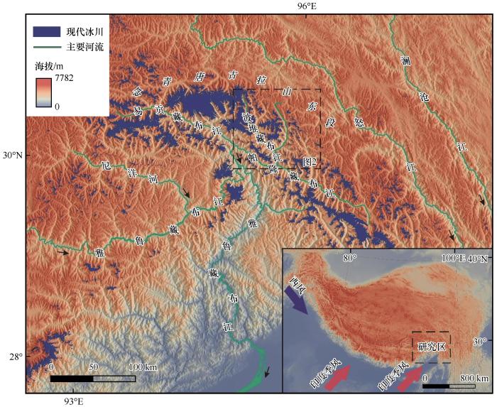
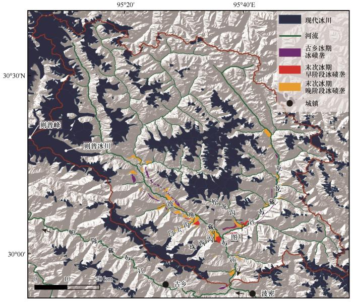
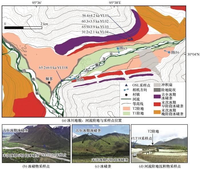
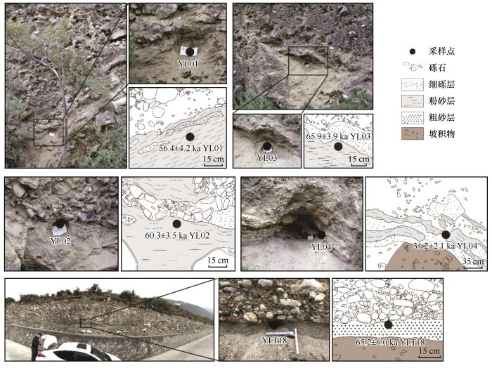
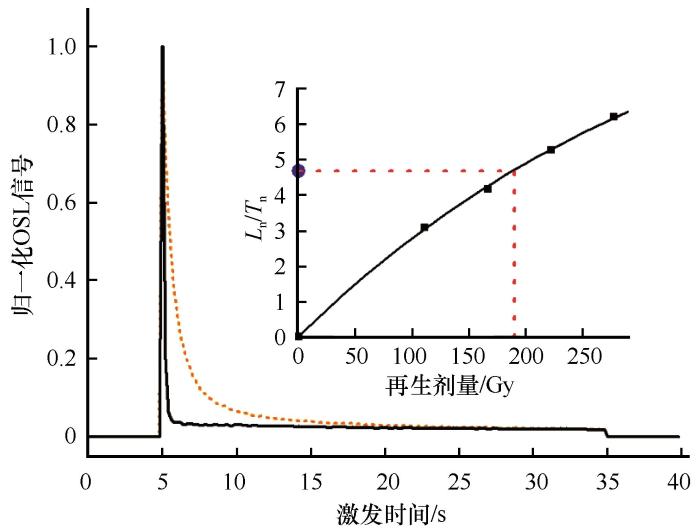
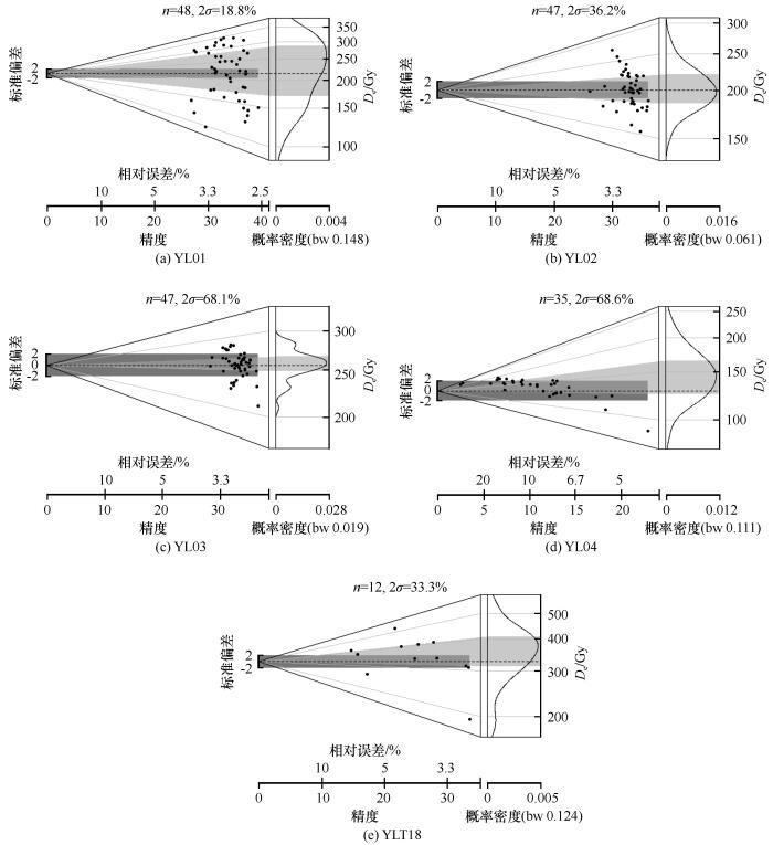
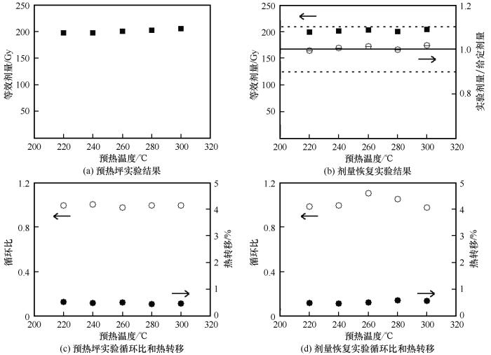
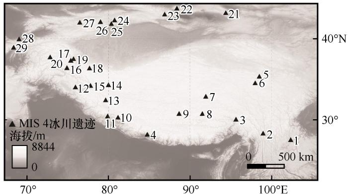
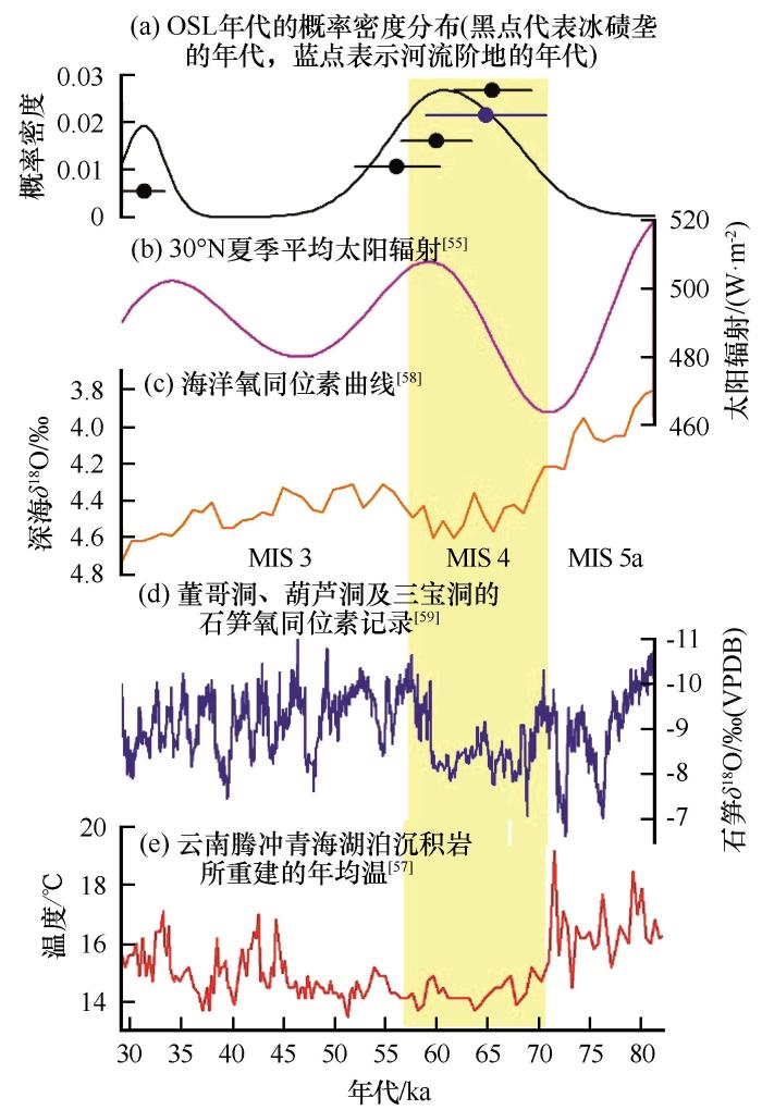

 甘公网安备 62010202000676号