Summary for policymakers
1
5
... 政府间气候变化专门委员会(IPCC)第六次评估报告对观测到的气候系统变化显示,人类活动估计造成了全球升温高于工业化前水平约1.0 ℃,可能区间为0.8~1.2 ℃.如果继续以目前的速率升温,全球升温可能会在2030年至2052年达到1.5 ℃(高信度).同时,报告显示了过去二十年以来,几乎全球范围内的冰川都呈现退缩状态(高信度)[1-2].冰川过度融化将会在区域和全球范围内造成严重影响[3-5]. ...
IPCC climate report: Earth is warmer than it’s been in 125,000 years
1
2021
... 政府间气候变化专门委员会(IPCC)第六次评估报告对观测到的气候系统变化显示,人类活动估计造成了全球升温高于工业化前水平约1.0 ℃,可能区间为0.8~1.2 ℃.如果继续以目前的速率升温,全球升温可能会在2030年至2052年达到1.5 ℃(高信度).同时,报告显示了过去二十年以来,几乎全球范围内的冰川都呈现退缩状态(高信度)[1-2].冰川过度融化将会在区域和全球范围内造成严重影响[3-5]. ...
A new model for global glacier change and sea-level rise
1
2015
... 政府间气候变化专门委员会(IPCC)第六次评估报告对观测到的气候系统变化显示,人类活动估计造成了全球升温高于工业化前水平约1.0 ℃,可能区间为0.8~1.2 ℃.如果继续以目前的速率升温,全球升温可能会在2030年至2052年达到1.5 ℃(高信度).同时,报告显示了过去二十年以来,几乎全球范围内的冰川都呈现退缩状态(高信度)[1-2].冰川过度融化将会在区域和全球范围内造成严重影响[3-5]. ...
Glacier shrinkage driving global changes in downstream systems
0
2017
A new look at roles of the cryosphere in sustainable development
1
2019
... 政府间气候变化专门委员会(IPCC)第六次评估报告对观测到的气候系统变化显示,人类活动估计造成了全球升温高于工业化前水平约1.0 ℃,可能区间为0.8~1.2 ℃.如果继续以目前的速率升温,全球升温可能会在2030年至2052年达到1.5 ℃(高信度).同时,报告显示了过去二十年以来,几乎全球范围内的冰川都呈现退缩状态(高信度)[1-2].冰川过度融化将会在区域和全球范围内造成严重影响[3-5]. ...
Equilibrium-line altitudes of late Quaternary glaciers in the Southern Alps, New Zealand
1
1975
... ELA是气候对冰川系统影响的关键参数,与当地气候条件密切相关.特别是固态降水和气温,即当气温升高,固态降水量减少时,ELA呈上升趋势,反之下降[6].在全球变暖的背景下,ELA变化的研究应该引起重视[7-8].ELA的计算主要是通过现代冰川卫星监测或数学模型模拟或者利用经验和统计方法等进行估算[9-13],随着人们对ELA对气候响应的逐步充分认识,更多的方法也被应用在ELA研究中,如利用ELA变化量与冰川物质和能量平衡的关系式进行计算等[14-16].尽管如此,由于青藏高原及其周边地区长时间尺度连续观测数据仅有几条冰川(主要有天山乌鲁木齐河源1号冰川和唐古拉山的小冬克玛底冰川),其余大多数监测冰川的平衡线高度只有近几年的观测资料,时间序列相对较短.同时,高原气象站点的分布主要集中于东缘,且部分冰川分布区没有站点检测数据,这在很大程度上限制了不同区域冰川平衡线高度变化状况及其气候敏感性的对比分析与研究[17-18]. ...
Different glacier status with atmospheric circulations in Tibetan Plateau and surroundings
1
2012
... ELA是气候对冰川系统影响的关键参数,与当地气候条件密切相关.特别是固态降水和气温,即当气温升高,固态降水量减少时,ELA呈上升趋势,反之下降[6].在全球变暖的背景下,ELA变化的研究应该引起重视[7-8].ELA的计算主要是通过现代冰川卫星监测或数学模型模拟或者利用经验和统计方法等进行估算[9-13],随着人们对ELA对气候响应的逐步充分认识,更多的方法也被应用在ELA研究中,如利用ELA变化量与冰川物质和能量平衡的关系式进行计算等[14-16].尽管如此,由于青藏高原及其周边地区长时间尺度连续观测数据仅有几条冰川(主要有天山乌鲁木齐河源1号冰川和唐古拉山的小冬克玛底冰川),其余大多数监测冰川的平衡线高度只有近几年的观测资料,时间序列相对较短.同时,高原气象站点的分布主要集中于东缘,且部分冰川分布区没有站点检测数据,这在很大程度上限制了不同区域冰川平衡线高度变化状况及其气候敏感性的对比分析与研究[17-18]. ...
Response of Xiao Dongkemadi Glacier in the central Tibetan Plateau to the current climate change and future scenarios by 2050
1
2016
... ELA是气候对冰川系统影响的关键参数,与当地气候条件密切相关.特别是固态降水和气温,即当气温升高,固态降水量减少时,ELA呈上升趋势,反之下降[6].在全球变暖的背景下,ELA变化的研究应该引起重视[7-8].ELA的计算主要是通过现代冰川卫星监测或数学模型模拟或者利用经验和统计方法等进行估算[9-13],随着人们对ELA对气候响应的逐步充分认识,更多的方法也被应用在ELA研究中,如利用ELA变化量与冰川物质和能量平衡的关系式进行计算等[14-16].尽管如此,由于青藏高原及其周边地区长时间尺度连续观测数据仅有几条冰川(主要有天山乌鲁木齐河源1号冰川和唐古拉山的小冬克玛底冰川),其余大多数监测冰川的平衡线高度只有近几年的观测资料,时间序列相对较短.同时,高原气象站点的分布主要集中于东缘,且部分冰川分布区没有站点检测数据,这在很大程度上限制了不同区域冰川平衡线高度变化状况及其气候敏感性的对比分析与研究[17-18]. ...
Climate at the equilibrium line of glaciers
1
1992
... ELA是气候对冰川系统影响的关键参数,与当地气候条件密切相关.特别是固态降水和气温,即当气温升高,固态降水量减少时,ELA呈上升趋势,反之下降[6].在全球变暖的背景下,ELA变化的研究应该引起重视[7-8].ELA的计算主要是通过现代冰川卫星监测或数学模型模拟或者利用经验和统计方法等进行估算[9-13],随着人们对ELA对气候响应的逐步充分认识,更多的方法也被应用在ELA研究中,如利用ELA变化量与冰川物质和能量平衡的关系式进行计算等[14-16].尽管如此,由于青藏高原及其周边地区长时间尺度连续观测数据仅有几条冰川(主要有天山乌鲁木齐河源1号冰川和唐古拉山的小冬克玛底冰川),其余大多数监测冰川的平衡线高度只有近几年的观测资料,时间序列相对较短.同时,高原气象站点的分布主要集中于东缘,且部分冰川分布区没有站点检测数据,这在很大程度上限制了不同区域冰川平衡线高度变化状况及其气候敏感性的对比分析与研究[17-18]. ...
Glacier response in the European Alps to Heinrich Event 1 cooling: the Gschnitz stadial
0
2006
Distribution and features of the glaciers’ ELAs and the decrease of ELAs during the Last Glaciation in China
1
2014
... ELA是气候对冰川系统影响的关键参数,与当地气候条件密切相关.特别是固态降水和气温,即当气温升高,固态降水量减少时,ELA呈上升趋势,反之下降[6].在全球变暖的背景下,ELA变化的研究应该引起重视[7-8].ELA的计算主要是通过现代冰川卫星监测或数学模型模拟或者利用经验和统计方法等进行估算[9-13],随着人们对ELA对气候响应的逐步充分认识,更多的方法也被应用在ELA研究中,如利用ELA变化量与冰川物质和能量平衡的关系式进行计算等[14-16].尽管如此,由于青藏高原及其周边地区长时间尺度连续观测数据仅有几条冰川(主要有天山乌鲁木齐河源1号冰川和唐古拉山的小冬克玛底冰川),其余大多数监测冰川的平衡线高度只有近几年的观测资料,时间序列相对较短.同时,高原气象站点的分布主要集中于东缘,且部分冰川分布区没有站点检测数据,这在很大程度上限制了不同区域冰川平衡线高度变化状况及其气候敏感性的对比分析与研究[17-18]. ...
中国现代冰川平衡线分布特征与末次冰期平衡线下降值研究
1
2014
... ELA是气候对冰川系统影响的关键参数,与当地气候条件密切相关.特别是固态降水和气温,即当气温升高,固态降水量减少时,ELA呈上升趋势,反之下降[6].在全球变暖的背景下,ELA变化的研究应该引起重视[7-8].ELA的计算主要是通过现代冰川卫星监测或数学模型模拟或者利用经验和统计方法等进行估算[9-13],随着人们对ELA对气候响应的逐步充分认识,更多的方法也被应用在ELA研究中,如利用ELA变化量与冰川物质和能量平衡的关系式进行计算等[14-16].尽管如此,由于青藏高原及其周边地区长时间尺度连续观测数据仅有几条冰川(主要有天山乌鲁木齐河源1号冰川和唐古拉山的小冬克玛底冰川),其余大多数监测冰川的平衡线高度只有近几年的观测资料,时间序列相对较短.同时,高原气象站点的分布主要集中于东缘,且部分冰川分布区没有站点检测数据,这在很大程度上限制了不同区域冰川平衡线高度变化状况及其气候敏感性的对比分析与研究[17-18]. ...
Last glacial maximum equilibrium-line altitude and paleo-temperature reconstructions for the Cordillera de Mérida, Venezuelan Andes
1
2007
... ELA是气候对冰川系统影响的关键参数,与当地气候条件密切相关.特别是固态降水和气温,即当气温升高,固态降水量减少时,ELA呈上升趋势,反之下降[6].在全球变暖的背景下,ELA变化的研究应该引起重视[7-8].ELA的计算主要是通过现代冰川卫星监测或数学模型模拟或者利用经验和统计方法等进行估算[9-13],随着人们对ELA对气候响应的逐步充分认识,更多的方法也被应用在ELA研究中,如利用ELA变化量与冰川物质和能量平衡的关系式进行计算等[14-16].尽管如此,由于青藏高原及其周边地区长时间尺度连续观测数据仅有几条冰川(主要有天山乌鲁木齐河源1号冰川和唐古拉山的小冬克玛底冰川),其余大多数监测冰川的平衡线高度只有近几年的观测资料,时间序列相对较短.同时,高原气象站点的分布主要集中于东缘,且部分冰川分布区没有站点检测数据,这在很大程度上限制了不同区域冰川平衡线高度变化状况及其气候敏感性的对比分析与研究[17-18]. ...
Palaeoclimate from glaciers: examples from the Eastern Alps during the Alpine Lateglacial and early Holocene
0
2007
Rapid decrease of mass balance observed in the Xiao (Lesser) Dongkemadi Glacier, in the central Tibetan Plateau
1
2008
... ELA是气候对冰川系统影响的关键参数,与当地气候条件密切相关.特别是固态降水和气温,即当气温升高,固态降水量减少时,ELA呈上升趋势,反之下降[6].在全球变暖的背景下,ELA变化的研究应该引起重视[7-8].ELA的计算主要是通过现代冰川卫星监测或数学模型模拟或者利用经验和统计方法等进行估算[9-13],随着人们对ELA对气候响应的逐步充分认识,更多的方法也被应用在ELA研究中,如利用ELA变化量与冰川物质和能量平衡的关系式进行计算等[14-16].尽管如此,由于青藏高原及其周边地区长时间尺度连续观测数据仅有几条冰川(主要有天山乌鲁木齐河源1号冰川和唐古拉山的小冬克玛底冰川),其余大多数监测冰川的平衡线高度只有近几年的观测资料,时间序列相对较短.同时,高原气象站点的分布主要集中于东缘,且部分冰川分布区没有站点检测数据,这在很大程度上限制了不同区域冰川平衡线高度变化状况及其气候敏感性的对比分析与研究[17-18]. ...
Variations in equilibrium line altitude of the Qiyi Glacier, Qilian Mountains, over the past 50 years
1
2010
... ELA是气候对冰川系统影响的关键参数,与当地气候条件密切相关.特别是固态降水和气温,即当气温升高,固态降水量减少时,ELA呈上升趋势,反之下降[6].在全球变暖的背景下,ELA变化的研究应该引起重视[7-8].ELA的计算主要是通过现代冰川卫星监测或数学模型模拟或者利用经验和统计方法等进行估算[9-13],随着人们对ELA对气候响应的逐步充分认识,更多的方法也被应用在ELA研究中,如利用ELA变化量与冰川物质和能量平衡的关系式进行计算等[14-16].尽管如此,由于青藏高原及其周边地区长时间尺度连续观测数据仅有几条冰川(主要有天山乌鲁木齐河源1号冰川和唐古拉山的小冬克玛底冰川),其余大多数监测冰川的平衡线高度只有近几年的观测资料,时间序列相对较短.同时,高原气象站点的分布主要集中于东缘,且部分冰川分布区没有站点检测数据,这在很大程度上限制了不同区域冰川平衡线高度变化状况及其气候敏感性的对比分析与研究[17-18]. ...
近50年来祁连山七一冰川平衡线高度变化研究
1
2010
... ELA是气候对冰川系统影响的关键参数,与当地气候条件密切相关.特别是固态降水和气温,即当气温升高,固态降水量减少时,ELA呈上升趋势,反之下降[6].在全球变暖的背景下,ELA变化的研究应该引起重视[7-8].ELA的计算主要是通过现代冰川卫星监测或数学模型模拟或者利用经验和统计方法等进行估算[9-13],随着人们对ELA对气候响应的逐步充分认识,更多的方法也被应用在ELA研究中,如利用ELA变化量与冰川物质和能量平衡的关系式进行计算等[14-16].尽管如此,由于青藏高原及其周边地区长时间尺度连续观测数据仅有几条冰川(主要有天山乌鲁木齐河源1号冰川和唐古拉山的小冬克玛底冰川),其余大多数监测冰川的平衡线高度只有近几年的观测资料,时间序列相对较短.同时,高原气象站点的分布主要集中于东缘,且部分冰川分布区没有站点检测数据,这在很大程度上限制了不同区域冰川平衡线高度变化状况及其气候敏感性的对比分析与研究[17-18]. ...
1
2005
... ELA是气候对冰川系统影响的关键参数,与当地气候条件密切相关.特别是固态降水和气温,即当气温升高,固态降水量减少时,ELA呈上升趋势,反之下降[6].在全球变暖的背景下,ELA变化的研究应该引起重视[7-8].ELA的计算主要是通过现代冰川卫星监测或数学模型模拟或者利用经验和统计方法等进行估算[9-13],随着人们对ELA对气候响应的逐步充分认识,更多的方法也被应用在ELA研究中,如利用ELA变化量与冰川物质和能量平衡的关系式进行计算等[14-16].尽管如此,由于青藏高原及其周边地区长时间尺度连续观测数据仅有几条冰川(主要有天山乌鲁木齐河源1号冰川和唐古拉山的小冬克玛底冰川),其余大多数监测冰川的平衡线高度只有近几年的观测资料,时间序列相对较短.同时,高原气象站点的分布主要集中于东缘,且部分冰川分布区没有站点检测数据,这在很大程度上限制了不同区域冰川平衡线高度变化状况及其气候敏感性的对比分析与研究[17-18]. ...
Dynamic variation of glaciers in Nyainqêntanglha Mountain during 1999—2015: evidence from remote sensing
3
2019
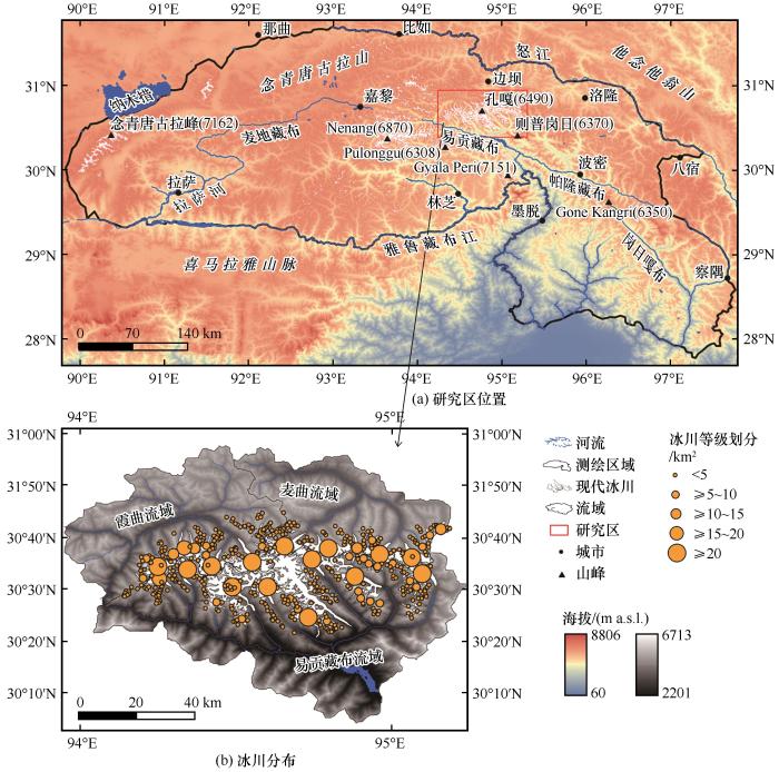
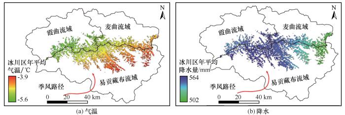
... 念青唐古拉山作为西南季风暖湿气流进入高原的通道和藏东南海洋型冰川区向唐古拉山大陆型冰川区的过渡区域,是青藏高原东南缘重要的山谷冰川分布区[19-20].对于念青唐古拉山区域内各冰川相关研究表明不同流域冰川变化及其特征差异显著[21-30].因此,在前人研究基础之上,本研究利用自然分域法,选取念青唐古拉山中段冰川分布区作为研究点,通过遥感影像、冰川编目数据以及气象数据提取与分析,利用气温与固态降水数据和ELA作为输入参数,尝试建立多元线性回归方程,重建研究区1984—2019年间冰川ELA,讨论并分析其年际尺度下的ELA变化趋势、区域异同性以及气候响应. ...
... 注:底图利用30-m ASTER(https://www.gscloud.cn)绘制,测绘区域以念青唐古拉山脉为界[19],现代冰川数据来自RGI 6.0[34],流域数据来自BasinATLAS_v10_lev07 (https://hydrosheds.org/downloads) ...
... [
19], the modern glacier data is from RGI 6.0
[34], and basin data is from BasinATLAS_v10_lev07 (https://hydrosheds.org/downloads)]
Fig. 1![]() 2 数据与方法2.1 数据来源
2 数据与方法2.1 数据来源气象数据来源于美国国家气候数据中心(ftp://ftp.ncdc.noaa.gov/pub/data/noaa/isd-lite/)和中国气象数据网(http://data.cma.cn).由于研究区没有气象站点,通过选取周边邻近地区8个气象站点,分别为丁青、类乌齐、昌都、洛隆、波密、八宿、察隅和林芝,利用标准克里金插值获取研究区数据,时间范围为1984—2019年.现代冰川数据来源于国家冰川冻土沙漠科学数据中心(www.ncdc.ac.cn)第二次冰川编目资料与Randolph Glacier Inventory(http://www.glims.org/RGI/)数据相互补充. ...
念青唐古拉山现代冰川1999—2015年期间动态变化遥感研究
3
2019
... 念青唐古拉山作为西南季风暖湿气流进入高原的通道和藏东南海洋型冰川区向唐古拉山大陆型冰川区的过渡区域,是青藏高原东南缘重要的山谷冰川分布区[19-20].对于念青唐古拉山区域内各冰川相关研究表明不同流域冰川变化及其特征差异显著[21-30].因此,在前人研究基础之上,本研究利用自然分域法,选取念青唐古拉山中段冰川分布区作为研究点,通过遥感影像、冰川编目数据以及气象数据提取与分析,利用气温与固态降水数据和ELA作为输入参数,尝试建立多元线性回归方程,重建研究区1984—2019年间冰川ELA,讨论并分析其年际尺度下的ELA变化趋势、区域异同性以及气候响应. ...
... 注:底图利用30-m ASTER(https://www.gscloud.cn)绘制,测绘区域以念青唐古拉山脉为界[19],现代冰川数据来自RGI 6.0[34],流域数据来自BasinATLAS_v10_lev07 (https://hydrosheds.org/downloads) ...
... [
19], the modern glacier data is from RGI 6.0
[34], and basin data is from BasinATLAS_v10_lev07 (https://hydrosheds.org/downloads)]
Fig. 1![]() 2 数据与方法2.1 数据来源
2 数据与方法2.1 数据来源气象数据来源于美国国家气候数据中心(ftp://ftp.ncdc.noaa.gov/pub/data/noaa/isd-lite/)和中国气象数据网(http://data.cma.cn).由于研究区没有气象站点,通过选取周边邻近地区8个气象站点,分别为丁青、类乌齐、昌都、洛隆、波密、八宿、察隅和林芝,利用标准克里金插值获取研究区数据,时间范围为1984—2019年.现代冰川数据来源于国家冰川冻土沙漠科学数据中心(www.ncdc.ac.cn)第二次冰川编目资料与Randolph Glacier Inventory(http://www.glims.org/RGI/)数据相互补充. ...
Glacier resources and their distributive characteristics in China: a review on Chinese glacier inventory
1
2000
... 念青唐古拉山作为西南季风暖湿气流进入高原的通道和藏东南海洋型冰川区向唐古拉山大陆型冰川区的过渡区域,是青藏高原东南缘重要的山谷冰川分布区[19-20].对于念青唐古拉山区域内各冰川相关研究表明不同流域冰川变化及其特征差异显著[21-30].因此,在前人研究基础之上,本研究利用自然分域法,选取念青唐古拉山中段冰川分布区作为研究点,通过遥感影像、冰川编目数据以及气象数据提取与分析,利用气温与固态降水数据和ELA作为输入参数,尝试建立多元线性回归方程,重建研究区1984—2019年间冰川ELA,讨论并分析其年际尺度下的ELA变化趋势、区域异同性以及气候响应. ...
中国冰川资源及其分布特征: 中国冰川目录编制完成
1
2000
... 念青唐古拉山作为西南季风暖湿气流进入高原的通道和藏东南海洋型冰川区向唐古拉山大陆型冰川区的过渡区域,是青藏高原东南缘重要的山谷冰川分布区[19-20].对于念青唐古拉山区域内各冰川相关研究表明不同流域冰川变化及其特征差异显著[21-30].因此,在前人研究基础之上,本研究利用自然分域法,选取念青唐古拉山中段冰川分布区作为研究点,通过遥感影像、冰川编目数据以及气象数据提取与分析,利用气温与固态降水数据和ELA作为输入参数,尝试建立多元线性回归方程,重建研究区1984—2019年间冰川ELA,讨论并分析其年际尺度下的ELA变化趋势、区域异同性以及气候响应. ...
Distribution and changes characteristics of glacial lakes in western Nyainqêntanglha Range during 1972—2009
1
2012
... 念青唐古拉山作为西南季风暖湿气流进入高原的通道和藏东南海洋型冰川区向唐古拉山大陆型冰川区的过渡区域,是青藏高原东南缘重要的山谷冰川分布区[19-20].对于念青唐古拉山区域内各冰川相关研究表明不同流域冰川变化及其特征差异显著[21-30].因此,在前人研究基础之上,本研究利用自然分域法,选取念青唐古拉山中段冰川分布区作为研究点,通过遥感影像、冰川编目数据以及气象数据提取与分析,利用气温与固态降水数据和ELA作为输入参数,尝试建立多元线性回归方程,重建研究区1984—2019年间冰川ELA,讨论并分析其年际尺度下的ELA变化趋势、区域异同性以及气候响应. ...
1972—2009年念青唐古拉山西段冰湖分布及其变化特征
1
2012
... 念青唐古拉山作为西南季风暖湿气流进入高原的通道和藏东南海洋型冰川区向唐古拉山大陆型冰川区的过渡区域,是青藏高原东南缘重要的山谷冰川分布区[19-20].对于念青唐古拉山区域内各冰川相关研究表明不同流域冰川变化及其特征差异显著[21-30].因此,在前人研究基础之上,本研究利用自然分域法,选取念青唐古拉山中段冰川分布区作为研究点,通过遥感影像、冰川编目数据以及气象数据提取与分析,利用气温与固态降水数据和ELA作为输入参数,尝试建立多元线性回归方程,重建研究区1984—2019年间冰川ELA,讨论并分析其年际尺度下的ELA变化趋势、区域异同性以及气候响应. ...
Glacier temporal-spatial change characteristics in western Nyainqêntanglha Range, Tibetan Plateau 1977—2010
0
2012
念青唐古拉山西段冰川1977—2010年时空变化
0
2012
Relationship between glacier retreat and climate change in eastern Nyainqêntanglha in the past 40 years
0
2015
近40年来念青唐古拉山东段则普乡地区冰川与气候变化研究
0
2015
Relation between glacier retreat and climate change in western Nyainqêntanglha in the past 40 years
0
2014
念青唐古拉山西段近40年冰川与气候变化研究
0
2014
Study on relationship between glacier retreat and climate change in the eastern Nyainqêntanglha in the past 40 years
0
2014
念青唐古拉山东段八盖乡地区近40年冰川与气候变化研究
0
2014
Ice volume and characteristics of sub-glacial topography of the Zhadang Glacier, Nyainqêntanglha Range
0
2014
念青唐古拉山扎当冰川冰储量估算及冰下地形特征分析
0
2014
Lake ice change at the Nam Co Lake on the Tibetan Plateau during 2000—2013 and influencing factors
0
2015
2000—2013年西藏纳木错湖冰变化及其影响因素
0
2015
Glacier change in the Nyainqêntanglha Mountain in 36 years and its response to climate change
0
2019
念青唐古拉山脉36年来冰川变化及其对气候变化的响应
0
2019
Glacier mass balance over the central Nyainqêntanglha Range during recent decades derived from remote-sensing data
0
2019
Glacier mass balance in the Nyainqentanglha Mountains between 2000 and 2017 retrieved from ZiYuan-3 stereo images and the SRTM DEM
1
2020
... 念青唐古拉山作为西南季风暖湿气流进入高原的通道和藏东南海洋型冰川区向唐古拉山大陆型冰川区的过渡区域,是青藏高原东南缘重要的山谷冰川分布区[19-20].对于念青唐古拉山区域内各冰川相关研究表明不同流域冰川变化及其特征差异显著[21-30].因此,在前人研究基础之上,本研究利用自然分域法,选取念青唐古拉山中段冰川分布区作为研究点,通过遥感影像、冰川编目数据以及气象数据提取与分析,利用气温与固态降水数据和ELA作为输入参数,尝试建立多元线性回归方程,重建研究区1984—2019年间冰川ELA,讨论并分析其年际尺度下的ELA变化趋势、区域异同性以及气候响应. ...
1:250 000 Biru, Dengqen, Lhari and Banbar Sheets in Xizang
1
2005
... 念青唐古拉山中段冰川作用区位于怒江流域以南,雅鲁藏布江大拐弯西北部的麦曲流域、霞曲流域及易贡湖以西的易贡藏布流域(图1).地势南高北低,海拔5 500 m以上,相对高差大于1 000 m,平均海拔3 600 m.气候属高原温带半湿润气候类型.年极端最低气温为-40 ℃,年平均气温为-1 ℃,年均降水量为400~700 mm[31-32].冰川编目资料显示[33],区域内共有500条现代冰川,面积为2 716.608 km2,以中小型冰川(面积<5 km2)为主,约占区域整体冰川的78%,规模相对较大(面积≥10 km2)的冰川有47条,平均海拔范围为3 000~6 000 m,主峰孔嘎峰海拔6 490 m. ...
1∶25万比如县幅、丁青县幅、嘉黎县幅、边坝县幅地质调查成果与进展
1
2005
... 念青唐古拉山中段冰川作用区位于怒江流域以南,雅鲁藏布江大拐弯西北部的麦曲流域、霞曲流域及易贡湖以西的易贡藏布流域(图1).地势南高北低,海拔5 500 m以上,相对高差大于1 000 m,平均海拔3 600 m.气候属高原温带半湿润气候类型.年极端最低气温为-40 ℃,年平均气温为-1 ℃,年均降水量为400~700 mm[31-32].冰川编目资料显示[33],区域内共有500条现代冰川,面积为2 716.608 km2,以中小型冰川(面积<5 km2)为主,约占区域整体冰川的78%,规模相对较大(面积≥10 km2)的冰川有47条,平均海拔范围为3 000~6 000 m,主峰孔嘎峰海拔6 490 m. ...
Study on glacier change in Nyainqêntanglha Mountain based on remote sensing
2
2017
... 念青唐古拉山中段冰川作用区位于怒江流域以南,雅鲁藏布江大拐弯西北部的麦曲流域、霞曲流域及易贡湖以西的易贡藏布流域(图1).地势南高北低,海拔5 500 m以上,相对高差大于1 000 m,平均海拔3 600 m.气候属高原温带半湿润气候类型.年极端最低气温为-40 ℃,年平均气温为-1 ℃,年均降水量为400~700 mm[31-32].冰川编目资料显示[33],区域内共有500条现代冰川,面积为2 716.608 km2,以中小型冰川(面积<5 km2)为主,约占区域整体冰川的78%,规模相对较大(面积≥10 km2)的冰川有47条,平均海拔范围为3 000~6 000 m,主峰孔嘎峰海拔6 490 m. ...
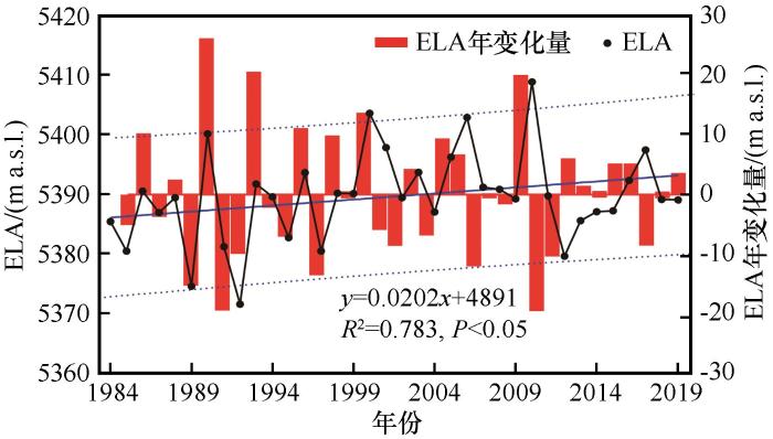
... 利用有冰川纪录的年份对1984—2019年间研究区冰川ELA模拟结果进行验证,冰川编目资料[32]记录了1989—1990年、1999—2000年及2010—2011年研究区冰川变化特征,对应ELA分别为5 140.1 m、5 403.5 m和5 408.8 m,利用上述方程[式(2)]计算ELA结果分别为5 182.5 m、5 375.0 m和5 390.0 m,ELA模拟值与测量值具有高度一致性,确定系数为0.9977. ...
基于遥感的念青唐古拉山冰川变化研究
2
2017
... 念青唐古拉山中段冰川作用区位于怒江流域以南,雅鲁藏布江大拐弯西北部的麦曲流域、霞曲流域及易贡湖以西的易贡藏布流域(图1).地势南高北低,海拔5 500 m以上,相对高差大于1 000 m,平均海拔3 600 m.气候属高原温带半湿润气候类型.年极端最低气温为-40 ℃,年平均气温为-1 ℃,年均降水量为400~700 mm[31-32].冰川编目资料显示[33],区域内共有500条现代冰川,面积为2 716.608 km2,以中小型冰川(面积<5 km2)为主,约占区域整体冰川的78%,规模相对较大(面积≥10 km2)的冰川有47条,平均海拔范围为3 000~6 000 m,主峰孔嘎峰海拔6 490 m. ...
... 利用有冰川纪录的年份对1984—2019年间研究区冰川ELA模拟结果进行验证,冰川编目资料[32]记录了1989—1990年、1999—2000年及2010—2011年研究区冰川变化特征,对应ELA分别为5 140.1 m、5 403.5 m和5 408.8 m,利用上述方程[式(2)]计算ELA结果分别为5 182.5 m、5 375.0 m和5 390.0 m,ELA模拟值与测量值具有高度一致性,确定系数为0.9977. ...
The second glacial catalogue data set of China (v
2
1
... 念青唐古拉山中段冰川作用区位于怒江流域以南,雅鲁藏布江大拐弯西北部的麦曲流域、霞曲流域及易贡湖以西的易贡藏布流域(图1).地势南高北低,海拔5 500 m以上,相对高差大于1 000 m,平均海拔3 600 m.气候属高原温带半湿润气候类型.年极端最低气温为-40 ℃,年平均气温为-1 ℃,年均降水量为400~700 mm[31-32].冰川编目资料显示[33],区域内共有500条现代冰川,面积为2 716.608 km2,以中小型冰川(面积<5 km2)为主,约占区域整体冰川的78%,规模相对较大(面积≥10 km2)的冰川有47条,平均海拔范围为3 000~6 000 m,主峰孔嘎峰海拔6 490 m. ...
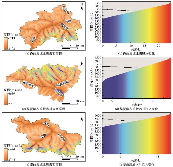
... 从冰川规模来看,易贡藏布流域冰川规模最大,最大冰川长度为33 km[图5(d)],总面积为1 238.809 km2,麦曲流域次之,霞曲流域最小,最大冰川长度分别为24 km[图5(b)]和19 km[图5(f)],总面积分别为760.817 km2和716.982 km2[33].相关研究表明,冰川对气候变化的反馈作用[52]以及冰川变化对气候的响应具有滞后效应[53],使得尽管相较于易贡藏布流域冰川区,霞曲流域水热组合状况更优,但冰川规模相对较小,ELA变化对气候响应更敏感.这也是造成短时间尺度范围同一气候区域冰川ELA变化差异性的重要原因. ...
中国第二次冰川编目数据集(v
2
1
... 念青唐古拉山中段冰川作用区位于怒江流域以南,雅鲁藏布江大拐弯西北部的麦曲流域、霞曲流域及易贡湖以西的易贡藏布流域(图1).地势南高北低,海拔5 500 m以上,相对高差大于1 000 m,平均海拔3 600 m.气候属高原温带半湿润气候类型.年极端最低气温为-40 ℃,年平均气温为-1 ℃,年均降水量为400~700 mm[31-32].冰川编目资料显示[33],区域内共有500条现代冰川,面积为2 716.608 km2,以中小型冰川(面积<5 km2)为主,约占区域整体冰川的78%,规模相对较大(面积≥10 km2)的冰川有47条,平均海拔范围为3 000~6 000 m,主峰孔嘎峰海拔6 490 m. ...
... 从冰川规模来看,易贡藏布流域冰川规模最大,最大冰川长度为33 km[图5(d)],总面积为1 238.809 km2,麦曲流域次之,霞曲流域最小,最大冰川长度分别为24 km[图5(b)]和19 km[图5(f)],总面积分别为760.817 km2和716.982 km2[33].相关研究表明,冰川对气候变化的反馈作用[52]以及冰川变化对气候的响应具有滞后效应[53],使得尽管相较于易贡藏布流域冰川区,霞曲流域水热组合状况更优,但冰川规模相对较小,ELA变化对气候响应更敏感.这也是造成短时间尺度范围同一气候区域冰川ELA变化差异性的重要原因. ...
Randolph glacier inventory: a dataset of global glacier outlines: version 6.0
2
2017
... 注:底图利用30-m ASTER(https://www.gscloud.cn)绘制,测绘区域以念青唐古拉山脉为界[19],现代冰川数据来自RGI 6.0[34],流域数据来自BasinATLAS_v10_lev07 (https://hydrosheds.org/downloads) ...
... [
34], and basin data is from BasinATLAS_v10_lev07 (https://hydrosheds.org/downloads)]
Fig. 1![]() 2 数据与方法2.1 数据来源
2 数据与方法2.1 数据来源气象数据来源于美国国家气候数据中心(ftp://ftp.ncdc.noaa.gov/pub/data/noaa/isd-lite/)和中国气象数据网(http://data.cma.cn).由于研究区没有气象站点,通过选取周边邻近地区8个气象站点,分别为丁青、类乌齐、昌都、洛隆、波密、八宿、察隅和林芝,利用标准克里金插值获取研究区数据,时间范围为1984—2019年.现代冰川数据来源于国家冰川冻土沙漠科学数据中心(www.ncdc.ac.cn)第二次冰川编目资料与Randolph Glacier Inventory(http://www.glims.org/RGI/)数据相互补充. ...
Using radar data to partition precipitation into rain and snow in a hydrologic model
1
2006
... 临界气温法区分固液态降水是冰川物质平衡模型中最常用的方法.主要包括双临界气温分离法与单临界气温分离法.双临界气温分离法只适用于我国的一些干旱地区,单临界气温法具有普遍适用性且具有较高精度[35-37].本研究中采用单临界气温法[38]. ...
A discuss of the separating solid and liquid precipitations
0
2010
Establishment and verification of single threshold temperature model for partition precipitation phase separation
1
2018
... 临界气温法区分固液态降水是冰川物质平衡模型中最常用的方法.主要包括双临界气温分离法与单临界气温分离法.双临界气温分离法只适用于我国的一些干旱地区,单临界气温法具有普遍适用性且具有较高精度[35-37].本研究中采用单临界气温法[38]. ...
降水相态分离单临界气温模型建立和检验
1
2018
... 临界气温法区分固液态降水是冰川物质平衡模型中最常用的方法.主要包括双临界气温分离法与单临界气温分离法.双临界气温分离法只适用于我国的一些干旱地区,单临界气温法具有普遍适用性且具有较高精度[35-37].本研究中采用单临界气温法[38]. ...
A model for simulating the response of runoff from the mountainous watersheds of inland river basins in the arid area of Northwest China to climatic changes
2
1999
... 临界气温法区分固液态降水是冰川物质平衡模型中最常用的方法.主要包括双临界气温分离法与单临界气温分离法.双临界气温分离法只适用于我国的一些干旱地区,单临界气温法具有普遍适用性且具有较高精度[35-37].本研究中采用单临界气温法[38]. ...
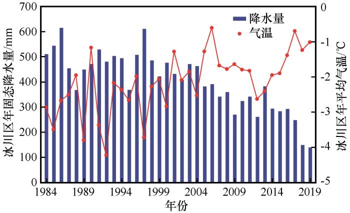
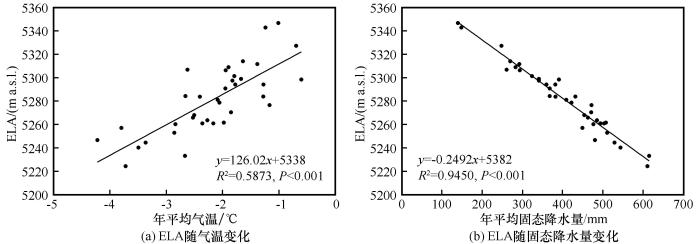
... 式中:Ps为月固态降水量(mm);P为月降水量(mm);T为月平均气温(℃);Tl为液态降水临界气温值(℃);Ts为固态降水临界气温值(℃).为获取研究区固态降水数据,首先参考康尔泗等[38]与张太刚等[39]临界气温方法划分固液态降水的方案,分别取0 ℃和2 ℃作为固液降水的划分阈值.研究区气象资料显示,冰川作用现代冰川区固态降水临界气温为-4.2~-0.6 ℃(图2,折线),平均固态降水量为140~614 mm(图2,条带). ...
西北干旱区内陆河流域出山径流变化趋势对气候变化响应模型
2
1999
... 临界气温法区分固液态降水是冰川物质平衡模型中最常用的方法.主要包括双临界气温分离法与单临界气温分离法.双临界气温分离法只适用于我国的一些干旱地区,单临界气温法具有普遍适用性且具有较高精度[35-37].本研究中采用单临界气温法[38]. ...
... 式中:Ps为月固态降水量(mm);P为月降水量(mm);T为月平均气温(℃);Tl为液态降水临界气温值(℃);Ts为固态降水临界气温值(℃).为获取研究区固态降水数据,首先参考康尔泗等[38]与张太刚等[39]临界气温方法划分固液态降水的方案,分别取0 ℃和2 ℃作为固液降水的划分阈值.研究区气象资料显示,冰川作用现代冰川区固态降水临界气温为-4.2~-0.6 ℃(图2,折线),平均固态降水量为140~614 mm(图2,条带). ...
Snow/ice albedo variation and its impact on glacier mass balance in the Qilian Mountains
1
2021
... 式中:Ps为月固态降水量(mm);P为月降水量(mm);T为月平均气温(℃);Tl为液态降水临界气温值(℃);Ts为固态降水临界气温值(℃).为获取研究区固态降水数据,首先参考康尔泗等[38]与张太刚等[39]临界气温方法划分固液态降水的方案,分别取0 ℃和2 ℃作为固液降水的划分阈值.研究区气象资料显示,冰川作用现代冰川区固态降水临界气温为-4.2~-0.6 ℃(图2,折线),平均固态降水量为140~614 mm(图2,条带). ...
祁连山区雪冰反照率变化及其对冰川物质平衡的影响
1
2021
... 式中:Ps为月固态降水量(mm);P为月降水量(mm);T为月平均气温(℃);Tl为液态降水临界气温值(℃);Ts为固态降水临界气温值(℃).为获取研究区固态降水数据,首先参考康尔泗等[38]与张太刚等[39]临界气温方法划分固液态降水的方案,分别取0 ℃和2 ℃作为固液降水的划分阈值.研究区气象资料显示,冰川作用现代冰川区固态降水临界气温为-4.2~-0.6 ℃(图2,折线),平均固态降水量为140~614 mm(图2,条带). ...
The use of hypsometry to indicate long-term stability and response of valley glaciers to changes in mass transfer
1
1984
... 积累区面积比率法(accumulation area ratio, AAR)与面积-高程平衡率法(area-altitude balance ratio, AABR)是目前最广泛使用的冰川ELA计算方法[40-41].基于AAR与AABR法基本原理,本研究使用Pellitero等[41]开发的自动计算ELA工具(https://github.com/cageo/Pellitero-2015).该工具计算ELA过程主要包括两个部分:输入需要重建冰川表面的数字高程模型(digital elevation model, DEM)和定义AABR与AAR值,即可快速计算出单条冰川或多条冰川数据集. ...
A GIS tool for automatic calculation of glacier equilibrium-line altitudes
2
2015
... 积累区面积比率法(accumulation area ratio, AAR)与面积-高程平衡率法(area-altitude balance ratio, AABR)是目前最广泛使用的冰川ELA计算方法[40-41].基于AAR与AABR法基本原理,本研究使用Pellitero等[41]开发的自动计算ELA工具(https://github.com/cageo/Pellitero-2015).该工具计算ELA过程主要包括两个部分:输入需要重建冰川表面的数字高程模型(digital elevation model, DEM)和定义AABR与AAR值,即可快速计算出单条冰川或多条冰川数据集. ...
... [41]开发的自动计算ELA工具(https://github.com/cageo/Pellitero-2015).该工具计算ELA过程主要包括两个部分:输入需要重建冰川表面的数字高程模型(digital elevation model, DEM)和定义AABR与AAR值,即可快速计算出单条冰川或多条冰川数据集. ...
Size specific steady-state accumulation-area ratio: an improvement for equilibrium-line estimation of small palaeoglaciers
1
2010
... 具体操作步骤如下:①输入需要重建冰川表面的DEM.设置用于冰川面积计算的等高线区间,本研究设置为50 m.②定义AABR与AAR值.为获取适合本研究区的AABR与AAR值,需要对其进行确定.AAR值的确定利用Kern等[42]系统总结分析了全球不同地区的46条山谷和冰斗冰川的面积S与其稳定状态下的AAR值之间的关系式,为AAR=0.0648lnS+0.483.由此,计算得出本研究区域AAR值为0.74±0.02.AABR值的确定是基于Rea[43]系统评估了全球冰川的物质平衡提出的适用于全球范围内的BR平均值为1.75±0.71.鉴于同一地区有多个冰川,Benn等[44]建议对一个BR范围进行计算,然后选择ELA标准差最低的一个.利用该方法,计算得出本研究区的BR均值为1.78±0.68.③使用Osmaston[45]提出的最低标准差方法来确定冰川最佳ELA.返回结果为“ELA_values_AAR_and_AABR.txt”. ...
Defining modern day area-altitude balance ratios (AABRs) and their use in glacier-climate reconstructions
1
2009
... 具体操作步骤如下:①输入需要重建冰川表面的DEM.设置用于冰川面积计算的等高线区间,本研究设置为50 m.②定义AABR与AAR值.为获取适合本研究区的AABR与AAR值,需要对其进行确定.AAR值的确定利用Kern等[42]系统总结分析了全球不同地区的46条山谷和冰斗冰川的面积S与其稳定状态下的AAR值之间的关系式,为AAR=0.0648lnS+0.483.由此,计算得出本研究区域AAR值为0.74±0.02.AABR值的确定是基于Rea[43]系统评估了全球冰川的物质平衡提出的适用于全球范围内的BR平均值为1.75±0.71.鉴于同一地区有多个冰川,Benn等[44]建议对一个BR范围进行计算,然后选择ELA标准差最低的一个.利用该方法,计算得出本研究区的BR均值为1.78±0.68.③使用Osmaston[45]提出的最低标准差方法来确定冰川最佳ELA.返回结果为“ELA_values_AAR_and_AABR.txt”. ...
Reconstruction of equilibrium-line altitudes for tropical and sub-tropical glaciers
1
2005
... 具体操作步骤如下:①输入需要重建冰川表面的DEM.设置用于冰川面积计算的等高线区间,本研究设置为50 m.②定义AABR与AAR值.为获取适合本研究区的AABR与AAR值,需要对其进行确定.AAR值的确定利用Kern等[42]系统总结分析了全球不同地区的46条山谷和冰斗冰川的面积S与其稳定状态下的AAR值之间的关系式,为AAR=0.0648lnS+0.483.由此,计算得出本研究区域AAR值为0.74±0.02.AABR值的确定是基于Rea[43]系统评估了全球冰川的物质平衡提出的适用于全球范围内的BR平均值为1.75±0.71.鉴于同一地区有多个冰川,Benn等[44]建议对一个BR范围进行计算,然后选择ELA标准差最低的一个.利用该方法,计算得出本研究区的BR均值为1.78±0.68.③使用Osmaston[45]提出的最低标准差方法来确定冰川最佳ELA.返回结果为“ELA_values_AAR_and_AABR.txt”. ...
Estimates of glacier equilibrium line altitudes by the Area×Altitude, the Area×Altitude Balance Ratio and the Area×Altitude Balance Index methods and their validation
1
2005
... 具体操作步骤如下:①输入需要重建冰川表面的DEM.设置用于冰川面积计算的等高线区间,本研究设置为50 m.②定义AABR与AAR值.为获取适合本研究区的AABR与AAR值,需要对其进行确定.AAR值的确定利用Kern等[42]系统总结分析了全球不同地区的46条山谷和冰斗冰川的面积S与其稳定状态下的AAR值之间的关系式,为AAR=0.0648lnS+0.483.由此,计算得出本研究区域AAR值为0.74±0.02.AABR值的确定是基于Rea[43]系统评估了全球冰川的物质平衡提出的适用于全球范围内的BR平均值为1.75±0.71.鉴于同一地区有多个冰川,Benn等[44]建议对一个BR范围进行计算,然后选择ELA标准差最低的一个.利用该方法,计算得出本研究区的BR均值为1.78±0.68.③使用Osmaston[45]提出的最低标准差方法来确定冰川最佳ELA.返回结果为“ELA_values_AAR_and_AABR.txt”. ...
A statistical approach to estimate equilibrium line altitude (ELA) and its trend analysis on Naradu Glacier, Himachal Himalaya
1
2021
... Singh等[46]利用多元线性回归统计分析法对1979—2013年喜马拉雅山脉的纳拉杜冰川平衡线高度的统计估算及其趋势分析,Zekollari等[47]使用该方法描述了瑞士的Morteratsch冰川的表面质量平衡,Sakai等[48]利用多元线性回归统计分析了亚洲高山冰川对近期气候变化的响应.基于前人研究,利用编目资料数据与研究区已有相关遥感影像解译数据[49].利用ELA calculation toolbox计算工具,对研究区内1990年、1999年、2011年及2019年的ELA进行计算(表1).以气象站点数据(气温与固态降水量)和ELA数据作为输入参数,建立1984—2019年间念青唐古拉山中段现代冰川ELA变化多元线性回归方程. ...
Statistical modelling of the surface mass-balance variability of the Morteratsch Glacier, Switzerland: strong control of early melting season meteorological conditions
1
2018
... Singh等[46]利用多元线性回归统计分析法对1979—2013年喜马拉雅山脉的纳拉杜冰川平衡线高度的统计估算及其趋势分析,Zekollari等[47]使用该方法描述了瑞士的Morteratsch冰川的表面质量平衡,Sakai等[48]利用多元线性回归统计分析了亚洲高山冰川对近期气候变化的响应.基于前人研究,利用编目资料数据与研究区已有相关遥感影像解译数据[49].利用ELA calculation toolbox计算工具,对研究区内1990年、1999年、2011年及2019年的ELA进行计算(表1).以气象站点数据(气温与固态降水量)和ELA数据作为输入参数,建立1984—2019年间念青唐古拉山中段现代冰川ELA变化多元线性回归方程. ...
Contrasting glacier responses to recent climate change in High-Mountain Asia
1
2017
... Singh等[46]利用多元线性回归统计分析法对1979—2013年喜马拉雅山脉的纳拉杜冰川平衡线高度的统计估算及其趋势分析,Zekollari等[47]使用该方法描述了瑞士的Morteratsch冰川的表面质量平衡,Sakai等[48]利用多元线性回归统计分析了亚洲高山冰川对近期气候变化的响应.基于前人研究,利用编目资料数据与研究区已有相关遥感影像解译数据[49].利用ELA calculation toolbox计算工具,对研究区内1990年、1999年、2011年及2019年的ELA进行计算(表1).以气象站点数据(气温与固态降水量)和ELA数据作为输入参数,建立1984—2019年间念青唐古拉山中段现代冰川ELA变化多元线性回归方程. ...
Glacier change and response to climate in the northern slope of the middle Nyainqêntanglha Mountains during 1990—2020
1
2021
... Singh等[46]利用多元线性回归统计分析法对1979—2013年喜马拉雅山脉的纳拉杜冰川平衡线高度的统计估算及其趋势分析,Zekollari等[47]使用该方法描述了瑞士的Morteratsch冰川的表面质量平衡,Sakai等[48]利用多元线性回归统计分析了亚洲高山冰川对近期气候变化的响应.基于前人研究,利用编目资料数据与研究区已有相关遥感影像解译数据[49].利用ELA calculation toolbox计算工具,对研究区内1990年、1999年、2011年及2019年的ELA进行计算(表1).以气象站点数据(气温与固态降水量)和ELA数据作为输入参数,建立1984—2019年间念青唐古拉山中段现代冰川ELA变化多元线性回归方程. ...
1990—2020年间念青唐古拉山中段北坡边坝地区冰川变化及气候响应
1
2021
... Singh等[46]利用多元线性回归统计分析法对1979—2013年喜马拉雅山脉的纳拉杜冰川平衡线高度的统计估算及其趋势分析,Zekollari等[47]使用该方法描述了瑞士的Morteratsch冰川的表面质量平衡,Sakai等[48]利用多元线性回归统计分析了亚洲高山冰川对近期气候变化的响应.基于前人研究,利用编目资料数据与研究区已有相关遥感影像解译数据[49].利用ELA calculation toolbox计算工具,对研究区内1990年、1999年、2011年及2019年的ELA进行计算(表1).以气象站点数据(气温与固态降水量)和ELA数据作为输入参数,建立1984—2019年间念青唐古拉山中段现代冰川ELA变化多元线性回归方程. ...
Two peculiar phenomena of climatic and glacial variations in the Tibetan Plateau
1
2006
... 同时,为进一步对比验证模拟结果的有效性,通过对气象站1984—2019年的年平均气温、6—8月平均气温、年降水量和6—8月平均降水量进行分析,参考我国西部17条现代冰川的物质平衡以及气象观测资料[50],建立冰川物质平衡线处年降水量(PELA)与6—8月平均气温(TSO)的拟合方程[式(3)],并结合综合因子法[51][式(4)],来计算念青唐古拉山中段现代冰川ELA. ...
近30 a青藏高原气候与冰川变化中的两种特殊现象
1
2006
... 同时,为进一步对比验证模拟结果的有效性,通过对气象站1984—2019年的年平均气温、6—8月平均气温、年降水量和6—8月平均降水量进行分析,参考我国西部17条现代冰川的物质平衡以及气象观测资料[50],建立冰川物质平衡线处年降水量(PELA)与6—8月平均气温(TSO)的拟合方程[式(3)],并结合综合因子法[51][式(4)],来计算念青唐古拉山中段现代冰川ELA. ...
Theoretical glacial equilibrium line altitudes and their influencing factors in the typical mountains of China
1
2014
... 同时,为进一步对比验证模拟结果的有效性,通过对气象站1984—2019年的年平均气温、6—8月平均气温、年降水量和6—8月平均降水量进行分析,参考我国西部17条现代冰川的物质平衡以及气象观测资料[50],建立冰川物质平衡线处年降水量(PELA)与6—8月平均气温(TSO)的拟合方程[式(3)],并结合综合因子法[51][式(4)],来计算念青唐古拉山中段现代冰川ELA. ...
中国典型山地冰川平衡线的影响因素分析
1
2014
... 同时,为进一步对比验证模拟结果的有效性,通过对气象站1984—2019年的年平均气温、6—8月平均气温、年降水量和6—8月平均降水量进行分析,参考我国西部17条现代冰川的物质平衡以及气象观测资料[50],建立冰川物质平衡线处年降水量(PELA)与6—8月平均气温(TSO)的拟合方程[式(3)],并结合综合因子法[51][式(4)],来计算念青唐古拉山中段现代冰川ELA. ...
Interaction between glacier and climate change: taking No.1 Glacier at the source of Urumqi River in Tianshan Mountains as an example
1
2007
... 从冰川规模来看,易贡藏布流域冰川规模最大,最大冰川长度为33 km[图5(d)],总面积为1 238.809 km2,麦曲流域次之,霞曲流域最小,最大冰川长度分别为24 km[图5(b)]和19 km[图5(f)],总面积分别为760.817 km2和716.982 km2[33].相关研究表明,冰川对气候变化的反馈作用[52]以及冰川变化对气候的响应具有滞后效应[53],使得尽管相较于易贡藏布流域冰川区,霞曲流域水热组合状况更优,但冰川规模相对较小,ELA变化对气候响应更敏感.这也是造成短时间尺度范围同一气候区域冰川ELA变化差异性的重要原因. ...
冰川与气候变化相互作用: 以天山乌鲁木齐河源1号冰川为例
1
2007
... 从冰川规模来看,易贡藏布流域冰川规模最大,最大冰川长度为33 km[图5(d)],总面积为1 238.809 km2,麦曲流域次之,霞曲流域最小,最大冰川长度分别为24 km[图5(b)]和19 km[图5(f)],总面积分别为760.817 km2和716.982 km2[33].相关研究表明,冰川对气候变化的反馈作用[52]以及冰川变化对气候的响应具有滞后效应[53],使得尽管相较于易贡藏布流域冰川区,霞曲流域水热组合状况更优,但冰川规模相对较小,ELA变化对气候响应更敏感.这也是造成短时间尺度范围同一气候区域冰川ELA变化差异性的重要原因. ...
Mountain glacier fluctuations and climatic change during the last 100 years
1
1992
... 从冰川规模来看,易贡藏布流域冰川规模最大,最大冰川长度为33 km[图5(d)],总面积为1 238.809 km2,麦曲流域次之,霞曲流域最小,最大冰川长度分别为24 km[图5(b)]和19 km[图5(f)],总面积分别为760.817 km2和716.982 km2[33].相关研究表明,冰川对气候变化的反馈作用[52]以及冰川变化对气候的响应具有滞后效应[53],使得尽管相较于易贡藏布流域冰川区,霞曲流域水热组合状况更优,但冰川规模相对较小,ELA变化对气候响应更敏感.这也是造成短时间尺度范围同一气候区域冰川ELA变化差异性的重要原因. ...
近百年来山地冰川波动与气候变化
1
1992
... 从冰川规模来看,易贡藏布流域冰川规模最大,最大冰川长度为33 km[图5(d)],总面积为1 238.809 km2,麦曲流域次之,霞曲流域最小,最大冰川长度分别为24 km[图5(b)]和19 km[图5(f)],总面积分别为760.817 km2和716.982 km2[33].相关研究表明,冰川对气候变化的反馈作用[52]以及冰川变化对气候的响应具有滞后效应[53],使得尽管相较于易贡藏布流域冰川区,霞曲流域水热组合状况更优,但冰川规模相对较小,ELA变化对气候响应更敏感.这也是造成短时间尺度范围同一气候区域冰川ELA变化差异性的重要原因. ...
Recent glacial retreat in High Asia in China and its impact on water resource in Northwest China
1
2004
... 姚檀栋等[54]对高亚洲冰川总体退缩研究表明,气温升高引起的冰川消融量增加和粒雪线上升,是近百年来全球山地冰川呈现总的退缩趋势的主要原因.同时,Caidong等[55]研究发现,当温度变化为1 ℃时,ELA变化为140 m.段克勤等[56]对小冬克玛底冰川ELA的气候敏感性进行了试验,发现在气候状态基础上,假设其他气候因子不变,当气温增加1 ℃将引起冰川ELA大幅度上升160 m,而增加20%的降水量引起的ELA仅降低10 m,这也说明冰川ELA对气温变化较敏感. ...
高亚洲冰川的近期退缩及其对西北水资源的影响
1
2004
... 姚檀栋等[54]对高亚洲冰川总体退缩研究表明,气温升高引起的冰川消融量增加和粒雪线上升,是近百年来全球山地冰川呈现总的退缩趋势的主要原因.同时,Caidong等[55]研究发现,当温度变化为1 ℃时,ELA变化为140 m.段克勤等[56]对小冬克玛底冰川ELA的气候敏感性进行了试验,发现在气候状态基础上,假设其他气候因子不变,当气温增加1 ℃将引起冰川ELA大幅度上升160 m,而增加20%的降水量引起的ELA仅降低10 m,这也说明冰川ELA对气温变化较敏感. ...
Modelled mass balance of Xibu Glacier, Tibetan Plateau: sensitivity to climate change
1
2010
... 姚檀栋等[54]对高亚洲冰川总体退缩研究表明,气温升高引起的冰川消融量增加和粒雪线上升,是近百年来全球山地冰川呈现总的退缩趋势的主要原因.同时,Caidong等[55]研究发现,当温度变化为1 ℃时,ELA变化为140 m.段克勤等[56]对小冬克玛底冰川ELA的气候敏感性进行了试验,发现在气候状态基础上,假设其他气候因子不变,当气温增加1 ℃将引起冰川ELA大幅度上升160 m,而增加20%的降水量引起的ELA仅降低10 m,这也说明冰川ELA对气温变化较敏感. ...
Simulation and prediction of equilibrium line altitude of glaciers in the eastern Tibetan Plateau
1
2017
... 姚檀栋等[54]对高亚洲冰川总体退缩研究表明,气温升高引起的冰川消融量增加和粒雪线上升,是近百年来全球山地冰川呈现总的退缩趋势的主要原因.同时,Caidong等[55]研究发现,当温度变化为1 ℃时,ELA变化为140 m.段克勤等[56]对小冬克玛底冰川ELA的气候敏感性进行了试验,发现在气候状态基础上,假设其他气候因子不变,当气温增加1 ℃将引起冰川ELA大幅度上升160 m,而增加20%的降水量引起的ELA仅降低10 m,这也说明冰川ELA对气温变化较敏感. ...
青藏高原东部冰川平衡线高度的模拟及预测
1
2017
... 姚檀栋等[54]对高亚洲冰川总体退缩研究表明,气温升高引起的冰川消融量增加和粒雪线上升,是近百年来全球山地冰川呈现总的退缩趋势的主要原因.同时,Caidong等[55]研究发现,当温度变化为1 ℃时,ELA变化为140 m.段克勤等[56]对小冬克玛底冰川ELA的气候敏感性进行了试验,发现在气候状态基础上,假设其他气候因子不变,当气温增加1 ℃将引起冰川ELA大幅度上升160 m,而增加20%的降水量引起的ELA仅降低10 m,这也说明冰川ELA对气温变化较敏感. ...


 甘公网安备 62010202000676号