North America is rich in late Quaternary glaciation remnants. Over recent years, a large number of exposed ages of glacial boulders or bedrock have been obtained using cosmogenic radionuclide (CRN) dating, allowing a potential reconstruction of the North America’s late Quaternary evolutionary glaciation sequence. In this paper, the 10Be exposure ages of 4 357 independent samples from North America were compiled and classified according to confidence classes (A-C). All exposure ages were grouped according to the original literature and recalculated using the latest version of the exposure age calculator. Since the erosion rate of each study area could not be determined, the calculation of exposure ages in this study was based on a zero erosion assumption. We considered the ages we adopted to be minimum exposure ages. After division into confidence classes, 424 groups of 1 956 exposure ages with well-clustered and moderately-clustered classes were obtained. Due to considerable overlap of data, the overall range in glaciation in North America appeared too wide. We therefore constructed an evolutionary glaciation sequence and determined the peak age of the probability density curve for four large regions and 15 subregions in North America. The subdivision of regions at all levels was based on glacier shape, scale and topographic conditions. Combining these results with paleoclimate data, we compared and analyzed the response of the resulting evolutionary glaciation sequence to high-resolution climatic events, thereby summarizing the characteristics of each stage of the North American evolutionary glaciation sequence. The results showed that North America has experienced many glaciations in the past 150 ka. It is conservatively estimated that the glaciers in North America have experienced large-scale glaciations during at least marine isotope stage (MIS) 6/5, MIS 4/3 and MIS 2. The evolution of glaciers before the Last Glacial Maximum (LGM) was regional. Of these glaciations, the MIS 6/5 glaciation was concentrated in the western part of the United States, with peak ages of 138.7 ka and 118.7 ka, corresponding to the late MIS 6 and early MIS 5. Traces of a MIS 4/3 glaciation are only preserved in Alaska, possibly related to the atmospheric effect of the Laurentian Ice Sheet. The times when the LGM reached its maximum range may not be regionally synchronous. In addition to the principal mechanisms driven by the global climate change, changes in regional climates, the internal dynamics of different glaciers, and atmospheric effects brought about by the Laurentian Ice Sheet may also have been secondary factors. The responses of glaciers to the high-resolution climatic events known as the Heinrich Stadial 1 (HS-1), the Bølling-Allerød (B-A) interstadial and the Younger Dryas (YD) event, during the last period of deglaciation, appear to be synchronous, possibly affected by a significant change in the Atlantic meridional overturning circulation (AMOC). The 10Be exposure ages of North American glaciers also correlate well with the high-resolution ‘Bond’ events that have occurred during the Holocene. In the future, more 10Be exposure age data and climate data are needed to enrich the study of the evolutionary glaciation sequence in North America during the late Quaternary.
Keywords:10Be exposure ages
;
evolutionary glaciation sequence
;
climatic events
;
North America
LIU Liang, ZHAI Yijie, ZHANG Wei, CHU Zhihao. Late Quaternary glaciations in North America based on 10Be exposure ages[J]. Journal of Glaciology and Geocryology, 2022, 44(4): 1283-1297 doi:10.7522/j.issn.1000-0240.2022.0116
0 引言
第四纪气候演变以冷暖交替为特征,导致了冰川的不断进退[1-3],也造就了丰富的冰川遗迹。晚第四纪时期,北美洲受当时气候的影响在中高纬度形成了横跨大陆的北美冰盖复合体(North American Ice Sheet Complex,NAISC),作为北半球最大的冰盖,NAISC对气候、海平面、大气环流和人类的迁移都有着深刻的影响[4-5]。而在中低纬度的美国西部地区形成了对气候变化更为敏感的山岳冰川。丰富的冰川遗迹让人们能够更加了解古气候的变化特征,利用冰川沉积物年代构建的冰川演化序列,有助于了解冰川对全球气候强迫和反馈的敏感性。精确的冰川作用定年对于了解第四纪冰期、冰川演化过程和全球气候变化至关重要。其中,宇宙成因核素测年法应用于冰川年代学已经几十年[6],积累了大量的测年数据集。此方法通过测定岩石表面的同位素核素浓度就可以计算其暴露年代,从而获得冰川消退的确切时间[7-10]。
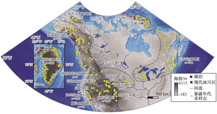
Fig. 1
Map of 10Be exposure ages deposit in the Quaternary glacier region of North America (Existing glacier data is from Randolph Glacier Inventory 6.0, and the Greenland region only shows periphery glaciers)
北美洲冰川10Be暴露年代数据来源于Expage[29](www.expage.github.io/, version expage-202103)。该数据库根据10Be产率的变化定期更新,汇编了来自全球各地已发布的10Be和26Al冰川暴露年代数据,其目的是允许轻松访问数据库,进而方便获取重新计算的暴露年代或对年代数据进行新的深入研究。
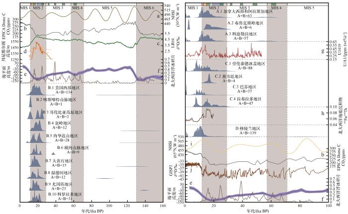
注:左图包括美国西部数据,冰期序列横跨MIS 6~1, 右图包括加拿大西部和阿拉斯加、劳伦泰德冰盖地区、格陵兰数据, 冰期序列横跨MIS 5~1, 左右两图合起来是一张图, 只是右图的时间序列比左图短; 在图的上部, 粉红色条块代表YD事件 (11.7~12.9 ka, 划分参考了文献[79]), 黄色条块代表B-A事件(12.9~14.6 ka, 划分参考了文献[79]), 绿色条块代表HS事件(HS1: 14.6~17.5 ka, 划分参考了文献[80-81]), 蓝色条块代表LGM时期 (19.0~26.5 ka, 划分参考了文献[71]), 深海氧同位素阶段划分参考了文献[2]; 古气候替代记录包含: a. 30°N的夏季日照辐射[82], b. EPICA Dome C 冰芯[83], c. LR04海洋底栖有孔虫中的δ18O[2], d. 邦尼维尔湖高度[53], e. 海平面高度[84], f. 北大西洋浮冰碎片[85], g. 阿拉斯加海底沉积物钻孔U1419[86], h. 北大西洋海底沉积物钻孔OCE326-GGC5[87], i. 65°N的夏季日照辐射[82], j. GISP2冰芯[88]
Fig. 2
Probability density plots of the class A and B 10Be exposure ages for each of the eighteen regions (The left figure includes data of western United States, and the glaciation sequence spans MIS 6~1, and the right figure includes data of western Canada and Alaska, the Laurentide Ice Sheet region and Greenland, and the glaciation sequence spans MIS 5~1, and the left and right figures are combined into one figure, but the time series of the right figure is shorter than that of the left figure; In the upper part of the figure, pink bars represent YD event (11.7~12.9 ka, the division refers to Reference [79]), yellow bars represent B-A event (12.9~14.6 ka, the division refers to Reference [79]), green bars represent HS events (HS1: 14.6~17.5 ka, the division refers to Reference [80-81]), blue bars represent the LGM (19.0~26.5 ka, the division refers to Reference [71]), and marine isotope stages division refers to Reference [2]; Paleoclimate proxy records contains: a. summer insolation at 30° N[82], b. EPICA Dome C ice core[83], c. LR04 series of marine δ18O in benthic foraminifers[2], d. Lake Bonneville altitudes[53], e. global sea level reconstruction[84], f. North Atlantic ice-rafted debris stack[85], g. Alaska deep-sea sediment core U1419[86], h. North Atlantic deep-sea sediment core OCE326-GGC5[87], i. summer insolation at 65° N[82], j. GISP2 ice core[88])
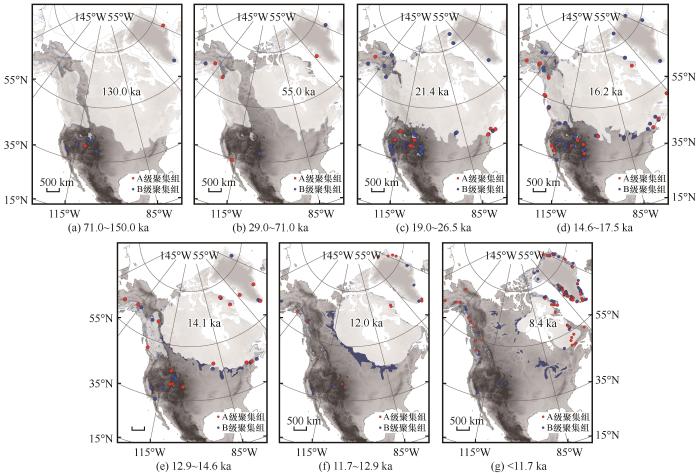
Fig. 3
Spatial distribution of the class A and B 10Be exposure ages for the seven temporal groups (71.0~150.0 ka, 29.0~71.0 ka, 19.0~26.5 ka, 14.6~17.5 ka, 12.9~14.6 ka, 11.7~12.9 ka and <11.7 ka) (An outline of ice sheets refers to Reference [17])
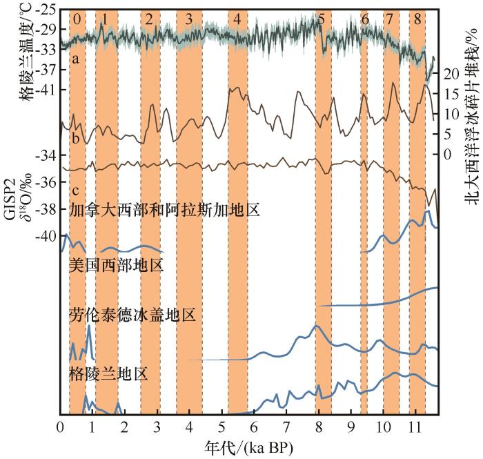
注:Bond事件划分参考了文献[108]; 古气候替代记录包含: a. 格陵兰温度重建[109], b. 北大西洋浮冰碎片堆栈[110], c. GISP2冰芯[88]
Fig. 4
Holocene probability density plots and Bond events in the four regions of North America (The classification of Bond events refers to Reference [108]; Paleoclimate proxy records contains: a. Greenland temperature reconstruction[109], b. ice-rafted debris stack from four North Atlantic sediment cores[110], c. GISP2 ice core[88])
[M]// Ruddiman W F, Wright H E, Jr. North America and adjacent oceans during the last deglaciation. Boulder, Colorado, USA: Geological Society of America, Inc, 1987: 111-136.
Timing and extent of Allerød and Younger Dryas age (ca. 12,500-10,000 14C yr BP) oscillations of the Cordilleran Ice Sheet in the Fraser Lowland, western North America
Pleistocene lake outburst floods and fan formation along the eastern Sierra Nevada, California: implications for the interpretation of intermontane lacustrine records
A stratigraphic framework for abrupt climatic changes during the Last Glacial period based on three synchronized Greenland ice-core records: refining and extending the INTIMATE event stratigraphy
Beryllium-10 chronology of early and late Wisconsinan moraines in the Revelation Mountains, Alaska: insights into the forcing of Wisconsinan glaciation in Beringia
... 第四纪气候演变以冷暖交替为特征,导致了冰川的不断进退[1-3],也造就了丰富的冰川遗迹.晚第四纪时期,北美洲受当时气候的影响在中高纬度形成了横跨大陆的北美冰盖复合体(North American Ice Sheet Complex,NAISC),作为北半球最大的冰盖,NAISC对气候、海平面、大气环流和人类的迁移都有着深刻的影响[4-5].而在中低纬度的美国西部地区形成了对气候变化更为敏感的山岳冰川.丰富的冰川遗迹让人们能够更加了解古气候的变化特征,利用冰川沉积物年代构建的冰川演化序列,有助于了解冰川对全球气候强迫和反馈的敏感性.精确的冰川作用定年对于了解第四纪冰期、冰川演化过程和全球气候变化至关重要.其中,宇宙成因核素测年法应用于冰川年代学已经几十年[6],积累了大量的测年数据集.此方法通过测定岩石表面的同位素核素浓度就可以计算其暴露年代,从而获得冰川消退的确切时间[7-10]. ...
A Pliocene-Pleistocene stack of 57 globally distributed benthic δ18O records
4
2005
... 注:左图包括美国西部数据,冰期序列横跨MIS 6~1, 右图包括加拿大西部和阿拉斯加、劳伦泰德冰盖地区、格陵兰数据, 冰期序列横跨MIS 5~1, 左右两图合起来是一张图, 只是右图的时间序列比左图短; 在图的上部, 粉红色条块代表YD事件 (11.7~12.9 ka, 划分参考了文献[79]), 黄色条块代表B-A事件(12.9~14.6 ka, 划分参考了文献[79]), 绿色条块代表HS事件(HS1: 14.6~17.5 ka, 划分参考了文献[80-81]), 蓝色条块代表LGM时期 (19.0~26.5 ka, 划分参考了文献[71]), 深海氧同位素阶段划分参考了文献[2]; 古气候替代记录包含: a. 30°N的夏季日照辐射[82], b. EPICA Dome C 冰芯[83], c. LR04海洋底栖有孔虫中的δ18O[2], d. 邦尼维尔湖高度[53], e. 海平面高度[84], f. 北大西洋浮冰碎片[85], g. 阿拉斯加海底沉积物钻孔U1419[86], h. 北大西洋海底沉积物钻孔OCE326-GGC5[87], i. 65°N的夏季日照辐射[82], j. GISP2冰芯[88] ...
... [2], d. 邦尼维尔湖高度[53], e. 海平面高度[84], f. 北大西洋浮冰碎片[85], g. 阿拉斯加海底沉积物钻孔U1419[86], h. 北大西洋海底沉积物钻孔OCE326-GGC5[87], i. 65°N的夏季日照辐射[82], j. GISP2冰芯[88] ...
... ]), and marine isotope stages division refers to Reference [2]; Paleoclimate proxy records contains: a. summer insolation at 30° N[82], b. EPICA Dome C ice core[83], c. LR04 series of marine δ18O in benthic foraminifers[2], d. Lake Bonneville altitudes[53], e. global sea level reconstruction[84], f. North Atlantic ice-rafted debris stack[85], g. Alaska deep-sea sediment core U1419[86], h. North Atlantic deep-sea sediment core OCE326-GGC5[87], i. summer insolation at 65° N[82], j. GISP2 ice core[88])Fig. 23.1.1 布鲁克斯岭地区
... [2], d. Lake Bonneville altitudes[53], e. global sea level reconstruction[84], f. North Atlantic ice-rafted debris stack[85], g. Alaska deep-sea sediment core U1419[86], h. North Atlantic deep-sea sediment core OCE326-GGC5[87], i. summer insolation at 65° N[82], j. GISP2 ice core[88])Fig. 23.1.1 布鲁克斯岭地区
Spatial distribution of the class A and B <sup>10</sup>Be exposure ages for the seven temporal groups (71.0~150.0 ka, 29.0~71.0 ka, 19.0~26.5 ka, 14.6~17.5 ka, 12.9~14.6 ka, 11.7~12.9 ka and <11.7 ka) (An outline of ice sheets refers to Reference [<xref ref-type="bibr" rid="R17">17</xref>])Fig. 3
... Be exposure ages for the seven temporal groups (71.0~150.0 ka, 29.0~71.0 ka, 19.0~26.5 ka, 14.6~17.5 ka, 12.9~14.6 ka, 11.7~12.9 ka and <11.7 ka) (An outline of ice sheets refers to Reference [17])Fig. 3
Boulder height-exposure age relationships from a global glacial 10Be compilation
2
2016
... 北美洲冰川10Be暴露年代数据来源于Expage[29](www.expage.github.io/, version expage-202103).该数据库根据10Be产率的变化定期更新,汇编了来自全球各地已发布的10Be和26Al冰川暴露年代数据,其目的是允许轻松访问数据库,进而方便获取重新计算的暴露年代或对年代数据进行新的深入研究. ...
Timing and extent of Aller?d and Younger Dryas age (ca. 12,500-10,000 14C yr BP) oscillations of the Cordilleran Ice Sheet in the Fraser Lowland, western North America
Chronology of Lake Bonneville, 30,000 to 10,000 yr BP
3
2015
... 注:左图包括美国西部数据,冰期序列横跨MIS 6~1, 右图包括加拿大西部和阿拉斯加、劳伦泰德冰盖地区、格陵兰数据, 冰期序列横跨MIS 5~1, 左右两图合起来是一张图, 只是右图的时间序列比左图短; 在图的上部, 粉红色条块代表YD事件 (11.7~12.9 ka, 划分参考了文献[79]), 黄色条块代表B-A事件(12.9~14.6 ka, 划分参考了文献[79]), 绿色条块代表HS事件(HS1: 14.6~17.5 ka, 划分参考了文献[80-81]), 蓝色条块代表LGM时期 (19.0~26.5 ka, 划分参考了文献[71]), 深海氧同位素阶段划分参考了文献[2]; 古气候替代记录包含: a. 30°N的夏季日照辐射[82], b. EPICA Dome C 冰芯[83], c. LR04海洋底栖有孔虫中的δ18O[2], d. 邦尼维尔湖高度[53], e. 海平面高度[84], f. 北大西洋浮冰碎片[85], g. 阿拉斯加海底沉积物钻孔U1419[86], h. 北大西洋海底沉积物钻孔OCE326-GGC5[87], i. 65°N的夏季日照辐射[82], j. GISP2冰芯[88] ...
... [53], e. global sea level reconstruction[84], f. North Atlantic ice-rafted debris stack[85], g. Alaska deep-sea sediment core U1419[86], h. North Atlantic deep-sea sediment core OCE326-GGC5[87], i. summer insolation at 65° N[82], j. GISP2 ice core[88])Fig. 23.1.1 布鲁克斯岭地区
Pleistocene lake outburst floods and fan formation along the eastern Sierra Nevada, California: implications for the interpretation of intermontane lacustrine records
... 注:左图包括美国西部数据,冰期序列横跨MIS 6~1, 右图包括加拿大西部和阿拉斯加、劳伦泰德冰盖地区、格陵兰数据, 冰期序列横跨MIS 5~1, 左右两图合起来是一张图, 只是右图的时间序列比左图短; 在图的上部, 粉红色条块代表YD事件 (11.7~12.9 ka, 划分参考了文献[79]), 黄色条块代表B-A事件(12.9~14.6 ka, 划分参考了文献[79]), 绿色条块代表HS事件(HS1: 14.6~17.5 ka, 划分参考了文献[80-81]), 蓝色条块代表LGM时期 (19.0~26.5 ka, 划分参考了文献[71]), 深海氧同位素阶段划分参考了文献[2]; 古气候替代记录包含: a. 30°N的夏季日照辐射[82], b. EPICA Dome C 冰芯[83], c. LR04海洋底栖有孔虫中的δ18O[2], d. 邦尼维尔湖高度[53], e. 海平面高度[84], f. 北大西洋浮冰碎片[85], g. 阿拉斯加海底沉积物钻孔U1419[86], h. 北大西洋海底沉积物钻孔OCE326-GGC5[87], i. 65°N的夏季日照辐射[82], j. GISP2冰芯[88] ...
... ]), blue bars represent the LGM (19.0~26.5 ka, the division refers to Reference [71]), and marine isotope stages division refers to Reference [2]; Paleoclimate proxy records contains: a. summer insolation at 30° N[82], b. EPICA Dome C ice core[83], c. LR04 series of marine δ18O in benthic foraminifers[2], d. Lake Bonneville altitudes[53], e. global sea level reconstruction[84], f. North Atlantic ice-rafted debris stack[85], g. Alaska deep-sea sediment core U1419[86], h. North Atlantic deep-sea sediment core OCE326-GGC5[87], i. summer insolation at 65° N[82], j. GISP2 ice core[88])Fig. 23.1.1 布鲁克斯岭地区
A stratigraphic framework for abrupt climatic changes during the Last Glacial period based on three synchronized Greenland ice-core records: refining and extending the INTIMATE event stratigraphy
4
2014
... 注:左图包括美国西部数据,冰期序列横跨MIS 6~1, 右图包括加拿大西部和阿拉斯加、劳伦泰德冰盖地区、格陵兰数据, 冰期序列横跨MIS 5~1, 左右两图合起来是一张图, 只是右图的时间序列比左图短; 在图的上部, 粉红色条块代表YD事件 (11.7~12.9 ka, 划分参考了文献[79]), 黄色条块代表B-A事件(12.9~14.6 ka, 划分参考了文献[79]), 绿色条块代表HS事件(HS1: 14.6~17.5 ka, 划分参考了文献[80-81]), 蓝色条块代表LGM时期 (19.0~26.5 ka, 划分参考了文献[71]), 深海氧同位素阶段划分参考了文献[2]; 古气候替代记录包含: a. 30°N的夏季日照辐射[82], b. EPICA Dome C 冰芯[83], c. LR04海洋底栖有孔虫中的δ18O[2], d. 邦尼维尔湖高度[53], e. 海平面高度[84], f. 北大西洋浮冰碎片[85], g. 阿拉斯加海底沉积物钻孔U1419[86], h. 北大西洋海底沉积物钻孔OCE326-GGC5[87], i. 65°N的夏季日照辐射[82], j. GISP2冰芯[88] ...
... ]), 黄色条块代表B-A事件(12.9~14.6 ka, 划分参考了文献[79]), 绿色条块代表HS事件(HS1: 14.6~17.5 ka, 划分参考了文献[80-81]), 蓝色条块代表LGM时期 (19.0~26.5 ka, 划分参考了文献[71]), 深海氧同位素阶段划分参考了文献[2]; 古气候替代记录包含: a. 30°N的夏季日照辐射[82], b. EPICA Dome C 冰芯[83], c. LR04海洋底栖有孔虫中的δ18O[2], d. 邦尼维尔湖高度[53], e. 海平面高度[84], f. 北大西洋浮冰碎片[85], g. 阿拉斯加海底沉积物钻孔U1419[86], h. 北大西洋海底沉积物钻孔OCE326-GGC5[87], i. 65°N的夏季日照辐射[82], j. GISP2冰芯[88] ...
... Be exposure ages for each of the eighteen regions (The left figure includes data of western United States, and the glaciation sequence spans MIS 6~1, and the right figure includes data of western Canada and Alaska, the Laurentide Ice Sheet region and Greenland, and the glaciation sequence spans MIS 5~1, and the left and right figures are combined into one figure, but the time series of the right figure is shorter than that of the left figure; In the upper part of the figure, pink bars represent YD event (11.7~12.9 ka, the division refers to Reference [79]), yellow bars represent B-A event (12.9~14.6 ka, the division refers to Reference [79]), green bars represent HS events (HS1: 14.6~17.5 ka, the division refers to Reference [80-81]), blue bars represent the LGM (19.0~26.5 ka, the division refers to Reference [71]), and marine isotope stages division refers to Reference [2]; Paleoclimate proxy records contains: a. summer insolation at 30° N[82], b. EPICA Dome C ice core[83], c. LR04 series of marine δ18O in benthic foraminifers[2], d. Lake Bonneville altitudes[53], e. global sea level reconstruction[84], f. North Atlantic ice-rafted debris stack[85], g. Alaska deep-sea sediment core U1419[86], h. North Atlantic deep-sea sediment core OCE326-GGC5[87], i. summer insolation at 65° N[82], j. GISP2 ice core[88])Fig. 23.1.1 布鲁克斯岭地区
... ]), yellow bars represent B-A event (12.9~14.6 ka, the division refers to Reference [79]), green bars represent HS events (HS1: 14.6~17.5 ka, the division refers to Reference [80-81]), blue bars represent the LGM (19.0~26.5 ka, the division refers to Reference [71]), and marine isotope stages division refers to Reference [2]; Paleoclimate proxy records contains: a. summer insolation at 30° N[82], b. EPICA Dome C ice core[83], c. LR04 series of marine δ18O in benthic foraminifers[2], d. Lake Bonneville altitudes[53], e. global sea level reconstruction[84], f. North Atlantic ice-rafted debris stack[85], g. Alaska deep-sea sediment core U1419[86], h. North Atlantic deep-sea sediment core OCE326-GGC5[87], i. summer insolation at 65° N[82], j. GISP2 ice core[88])Fig. 23.1.1 布鲁克斯岭地区
... 注:左图包括美国西部数据,冰期序列横跨MIS 6~1, 右图包括加拿大西部和阿拉斯加、劳伦泰德冰盖地区、格陵兰数据, 冰期序列横跨MIS 5~1, 左右两图合起来是一张图, 只是右图的时间序列比左图短; 在图的上部, 粉红色条块代表YD事件 (11.7~12.9 ka, 划分参考了文献[79]), 黄色条块代表B-A事件(12.9~14.6 ka, 划分参考了文献[79]), 绿色条块代表HS事件(HS1: 14.6~17.5 ka, 划分参考了文献[80-81]), 蓝色条块代表LGM时期 (19.0~26.5 ka, 划分参考了文献[71]), 深海氧同位素阶段划分参考了文献[2]; 古气候替代记录包含: a. 30°N的夏季日照辐射[82], b. EPICA Dome C 冰芯[83], c. LR04海洋底栖有孔虫中的δ18O[2], d. 邦尼维尔湖高度[53], e. 海平面高度[84], f. 北大西洋浮冰碎片[85], g. 阿拉斯加海底沉积物钻孔U1419[86], h. 北大西洋海底沉积物钻孔OCE326-GGC5[87], i. 65°N的夏季日照辐射[82], j. GISP2冰芯[88] ...
... ]), green bars represent HS events (HS1: 14.6~17.5 ka, the division refers to Reference [80-81]), blue bars represent the LGM (19.0~26.5 ka, the division refers to Reference [71]), and marine isotope stages division refers to Reference [2]; Paleoclimate proxy records contains: a. summer insolation at 30° N[82], b. EPICA Dome C ice core[83], c. LR04 series of marine δ18O in benthic foraminifers[2], d. Lake Bonneville altitudes[53], e. global sea level reconstruction[84], f. North Atlantic ice-rafted debris stack[85], g. Alaska deep-sea sediment core U1419[86], h. North Atlantic deep-sea sediment core OCE326-GGC5[87], i. summer insolation at 65° N[82], j. GISP2 ice core[88])Fig. 23.1.1 布鲁克斯岭地区
Millennial-scale climate variability and vegetation changes during the Last Glacial: concepts and terminology
2
2010
... 注:左图包括美国西部数据,冰期序列横跨MIS 6~1, 右图包括加拿大西部和阿拉斯加、劳伦泰德冰盖地区、格陵兰数据, 冰期序列横跨MIS 5~1, 左右两图合起来是一张图, 只是右图的时间序列比左图短; 在图的上部, 粉红色条块代表YD事件 (11.7~12.9 ka, 划分参考了文献[79]), 黄色条块代表B-A事件(12.9~14.6 ka, 划分参考了文献[79]), 绿色条块代表HS事件(HS1: 14.6~17.5 ka, 划分参考了文献[80-81]), 蓝色条块代表LGM时期 (19.0~26.5 ka, 划分参考了文献[71]), 深海氧同位素阶段划分参考了文献[2]; 古气候替代记录包含: a. 30°N的夏季日照辐射[82], b. EPICA Dome C 冰芯[83], c. LR04海洋底栖有孔虫中的δ18O[2], d. 邦尼维尔湖高度[53], e. 海平面高度[84], f. 北大西洋浮冰碎片[85], g. 阿拉斯加海底沉积物钻孔U1419[86], h. 北大西洋海底沉积物钻孔OCE326-GGC5[87], i. 65°N的夏季日照辐射[82], j. GISP2冰芯[88] ...
... -81]), blue bars represent the LGM (19.0~26.5 ka, the division refers to Reference [71]), and marine isotope stages division refers to Reference [2]; Paleoclimate proxy records contains: a. summer insolation at 30° N[82], b. EPICA Dome C ice core[83], c. LR04 series of marine δ18O in benthic foraminifers[2], d. Lake Bonneville altitudes[53], e. global sea level reconstruction[84], f. North Atlantic ice-rafted debris stack[85], g. Alaska deep-sea sediment core U1419[86], h. North Atlantic deep-sea sediment core OCE326-GGC5[87], i. summer insolation at 65° N[82], j. GISP2 ice core[88])Fig. 23.1.1 布鲁克斯岭地区
Insolation values for the climate of the last 10 million years
4
1991
... 注:左图包括美国西部数据,冰期序列横跨MIS 6~1, 右图包括加拿大西部和阿拉斯加、劳伦泰德冰盖地区、格陵兰数据, 冰期序列横跨MIS 5~1, 左右两图合起来是一张图, 只是右图的时间序列比左图短; 在图的上部, 粉红色条块代表YD事件 (11.7~12.9 ka, 划分参考了文献[79]), 黄色条块代表B-A事件(12.9~14.6 ka, 划分参考了文献[79]), 绿色条块代表HS事件(HS1: 14.6~17.5 ka, 划分参考了文献[80-81]), 蓝色条块代表LGM时期 (19.0~26.5 ka, 划分参考了文献[71]), 深海氧同位素阶段划分参考了文献[2]; 古气候替代记录包含: a. 30°N的夏季日照辐射[82], b. EPICA Dome C 冰芯[83], c. LR04海洋底栖有孔虫中的δ18O[2], d. 邦尼维尔湖高度[53], e. 海平面高度[84], f. 北大西洋浮冰碎片[85], g. 阿拉斯加海底沉积物钻孔U1419[86], h. 北大西洋海底沉积物钻孔OCE326-GGC5[87], i. 65°N的夏季日照辐射[82], j. GISP2冰芯[88] ...
... [82], j. GISP2冰芯[88] ...
... [82], b. EPICA Dome C ice core[83], c. LR04 series of marine δ18O in benthic foraminifers[2], d. Lake Bonneville altitudes[53], e. global sea level reconstruction[84], f. North Atlantic ice-rafted debris stack[85], g. Alaska deep-sea sediment core U1419[86], h. North Atlantic deep-sea sediment core OCE326-GGC5[87], i. summer insolation at 65° N[82], j. GISP2 ice core[88])Fig. 23.1.1 布鲁克斯岭地区
High-resolution carbon dioxide concentration record 650,000-800,000 years before present
2
2008
... 注:左图包括美国西部数据,冰期序列横跨MIS 6~1, 右图包括加拿大西部和阿拉斯加、劳伦泰德冰盖地区、格陵兰数据, 冰期序列横跨MIS 5~1, 左右两图合起来是一张图, 只是右图的时间序列比左图短; 在图的上部, 粉红色条块代表YD事件 (11.7~12.9 ka, 划分参考了文献[79]), 黄色条块代表B-A事件(12.9~14.6 ka, 划分参考了文献[79]), 绿色条块代表HS事件(HS1: 14.6~17.5 ka, 划分参考了文献[80-81]), 蓝色条块代表LGM时期 (19.0~26.5 ka, 划分参考了文献[71]), 深海氧同位素阶段划分参考了文献[2]; 古气候替代记录包含: a. 30°N的夏季日照辐射[82], b. EPICA Dome C 冰芯[83], c. LR04海洋底栖有孔虫中的δ18O[2], d. 邦尼维尔湖高度[53], e. 海平面高度[84], f. 北大西洋浮冰碎片[85], g. 阿拉斯加海底沉积物钻孔U1419[86], h. 北大西洋海底沉积物钻孔OCE326-GGC5[87], i. 65°N的夏季日照辐射[82], j. GISP2冰芯[88] ...
... [83], c. LR04 series of marine δ18O in benthic foraminifers[2], d. Lake Bonneville altitudes[53], e. global sea level reconstruction[84], f. North Atlantic ice-rafted debris stack[85], g. Alaska deep-sea sediment core U1419[86], h. North Atlantic deep-sea sediment core OCE326-GGC5[87], i. summer insolation at 65° N[82], j. GISP2 ice core[88])Fig. 23.1.1 布鲁克斯岭地区
An 800-kyr record of global surface ocean δ18O and implications for ice volume-temperature coupling
2
2015
... 注:左图包括美国西部数据,冰期序列横跨MIS 6~1, 右图包括加拿大西部和阿拉斯加、劳伦泰德冰盖地区、格陵兰数据, 冰期序列横跨MIS 5~1, 左右两图合起来是一张图, 只是右图的时间序列比左图短; 在图的上部, 粉红色条块代表YD事件 (11.7~12.9 ka, 划分参考了文献[79]), 黄色条块代表B-A事件(12.9~14.6 ka, 划分参考了文献[79]), 绿色条块代表HS事件(HS1: 14.6~17.5 ka, 划分参考了文献[80-81]), 蓝色条块代表LGM时期 (19.0~26.5 ka, 划分参考了文献[71]), 深海氧同位素阶段划分参考了文献[2]; 古气候替代记录包含: a. 30°N的夏季日照辐射[82], b. EPICA Dome C 冰芯[83], c. LR04海洋底栖有孔虫中的δ18O[2], d. 邦尼维尔湖高度[53], e. 海平面高度[84], f. 北大西洋浮冰碎片[85], g. 阿拉斯加海底沉积物钻孔U1419[86], h. 北大西洋海底沉积物钻孔OCE326-GGC5[87], i. 65°N的夏季日照辐射[82], j. GISP2冰芯[88] ...
... [84], f. North Atlantic ice-rafted debris stack[85], g. Alaska deep-sea sediment core U1419[86], h. North Atlantic deep-sea sediment core OCE326-GGC5[87], i. summer insolation at 65° N[82], j. GISP2 ice core[88])Fig. 23.1.1 布鲁克斯岭地区
Regional and global benthic δ18O stacks for the last glacial cycle
2
2016
... 注:左图包括美国西部数据,冰期序列横跨MIS 6~1, 右图包括加拿大西部和阿拉斯加、劳伦泰德冰盖地区、格陵兰数据, 冰期序列横跨MIS 5~1, 左右两图合起来是一张图, 只是右图的时间序列比左图短; 在图的上部, 粉红色条块代表YD事件 (11.7~12.9 ka, 划分参考了文献[79]), 黄色条块代表B-A事件(12.9~14.6 ka, 划分参考了文献[79]), 绿色条块代表HS事件(HS1: 14.6~17.5 ka, 划分参考了文献[80-81]), 蓝色条块代表LGM时期 (19.0~26.5 ka, 划分参考了文献[71]), 深海氧同位素阶段划分参考了文献[2]; 古气候替代记录包含: a. 30°N的夏季日照辐射[82], b. EPICA Dome C 冰芯[83], c. LR04海洋底栖有孔虫中的δ18O[2], d. 邦尼维尔湖高度[53], e. 海平面高度[84], f. 北大西洋浮冰碎片[85], g. 阿拉斯加海底沉积物钻孔U1419[86], h. 北大西洋海底沉积物钻孔OCE326-GGC5[87], i. 65°N的夏季日照辐射[82], j. GISP2冰芯[88] ...
... [85], g. Alaska deep-sea sediment core U1419[86], h. North Atlantic deep-sea sediment core OCE326-GGC5[87], i. summer insolation at 65° N[82], j. GISP2 ice core[88])Fig. 23.1.1 布鲁克斯岭地区
Reconstructing paleo-oxygenation for the last 54,000 years in the Gulf of Alaska using cross-validated benthic foraminiferal and geochemical records
2
2021
... 注:左图包括美国西部数据,冰期序列横跨MIS 6~1, 右图包括加拿大西部和阿拉斯加、劳伦泰德冰盖地区、格陵兰数据, 冰期序列横跨MIS 5~1, 左右两图合起来是一张图, 只是右图的时间序列比左图短; 在图的上部, 粉红色条块代表YD事件 (11.7~12.9 ka, 划分参考了文献[79]), 黄色条块代表B-A事件(12.9~14.6 ka, 划分参考了文献[79]), 绿色条块代表HS事件(HS1: 14.6~17.5 ka, 划分参考了文献[80-81]), 蓝色条块代表LGM时期 (19.0~26.5 ka, 划分参考了文献[71]), 深海氧同位素阶段划分参考了文献[2]; 古气候替代记录包含: a. 30°N的夏季日照辐射[82], b. EPICA Dome C 冰芯[83], c. LR04海洋底栖有孔虫中的δ18O[2], d. 邦尼维尔湖高度[53], e. 海平面高度[84], f. 北大西洋浮冰碎片[85], g. 阿拉斯加海底沉积物钻孔U1419[86], h. 北大西洋海底沉积物钻孔OCE326-GGC5[87], i. 65°N的夏季日照辐射[82], j. GISP2冰芯[88] ...
... [86], h. North Atlantic deep-sea sediment core OCE326-GGC5[87], i. summer insolation at 65° N[82], j. GISP2 ice core[88])Fig. 23.1.1 布鲁克斯岭地区
Collapse and rapid resumption of Atlantic meridional circulation linked to deglacial climate changes
2
2004
... 注:左图包括美国西部数据,冰期序列横跨MIS 6~1, 右图包括加拿大西部和阿拉斯加、劳伦泰德冰盖地区、格陵兰数据, 冰期序列横跨MIS 5~1, 左右两图合起来是一张图, 只是右图的时间序列比左图短; 在图的上部, 粉红色条块代表YD事件 (11.7~12.9 ka, 划分参考了文献[79]), 黄色条块代表B-A事件(12.9~14.6 ka, 划分参考了文献[79]), 绿色条块代表HS事件(HS1: 14.6~17.5 ka, 划分参考了文献[80-81]), 蓝色条块代表LGM时期 (19.0~26.5 ka, 划分参考了文献[71]), 深海氧同位素阶段划分参考了文献[2]; 古气候替代记录包含: a. 30°N的夏季日照辐射[82], b. EPICA Dome C 冰芯[83], c. LR04海洋底栖有孔虫中的δ18O[2], d. 邦尼维尔湖高度[53], e. 海平面高度[84], f. 北大西洋浮冰碎片[85], g. 阿拉斯加海底沉积物钻孔U1419[86], h. 北大西洋海底沉积物钻孔OCE326-GGC5[87], i. 65°N的夏季日照辐射[82], j. GISP2冰芯[88] ...
... [87], i. summer insolation at 65° N[82], j. GISP2 ice core[88])Fig. 23.1.1 布鲁克斯岭地区
Oxygen 18/16 variability in Greenland snow and ice with 10-3- to 105-year time resolution
5
1997
... 注:左图包括美国西部数据,冰期序列横跨MIS 6~1, 右图包括加拿大西部和阿拉斯加、劳伦泰德冰盖地区、格陵兰数据, 冰期序列横跨MIS 5~1, 左右两图合起来是一张图, 只是右图的时间序列比左图短; 在图的上部, 粉红色条块代表YD事件 (11.7~12.9 ka, 划分参考了文献[79]), 黄色条块代表B-A事件(12.9~14.6 ka, 划分参考了文献[79]), 绿色条块代表HS事件(HS1: 14.6~17.5 ka, 划分参考了文献[80-81]), 蓝色条块代表LGM时期 (19.0~26.5 ka, 划分参考了文献[71]), 深海氧同位素阶段划分参考了文献[2]; 古气候替代记录包含: a. 30°N的夏季日照辐射[82], b. EPICA Dome C 冰芯[83], c. LR04海洋底栖有孔虫中的δ18O[2], d. 邦尼维尔湖高度[53], e. 海平面高度[84], f. 北大西洋浮冰碎片[85], g. 阿拉斯加海底沉积物钻孔U1419[86], h. 北大西洋海底沉积物钻孔OCE326-GGC5[87], i. 65°N的夏季日照辐射[82], j. GISP2冰芯[88] ...
Beryllium-10 chronology of early and late Wisconsinan moraines in the Revelation Mountains, Alaska: insights into the forcing of Wisconsinan glaciation in Beringia
1
2018
... Summary table of topographic morphology and sample types of 10Be sampling points in pre-LGM stageTable 2
... 注:Bond事件划分参考了文献[108]; 古气候替代记录包含: a. 格陵兰温度重建[109], b. 北大西洋浮冰碎片堆栈[110], c. GISP2冰芯[88] ...
... Holocene probability density plots and Bond events in the four regions of North America (The classification of Bond events refers to Reference [108]; Paleoclimate proxy records contains: a. Greenland temperature reconstruction[109], b. ice-rafted debris stack from four North Atlantic sediment cores[110], c. GISP2 ice core[88])Fig. 45 结论


 甘公网安备 62010202000676号