Increasing rock-avalanche size and mobility in Glacier Bay National Park and Preserve, Alaska detected from 1984 to 2016 Landsat imagery
2
2018
... 在气候变暖、冰川退缩的影响下,高海拔区域的滑坡受冻融作用的控制发育愈加频繁[1 -3 ] .冰-岩碎屑流是一种在启动或运动时裹挟冰屑(冰、雪、粒雪等)的特殊高速远程滑坡,是高寒山区陡峭山体斜坡区冰崩、岩崩或滑坡解体后形成的冰屑、岩块和土颗粒混合体高速流动的现象[4 -6 ] .虽然多数冰-岩碎屑流发育于人迹罕至的高海拔地区,但其潜在的堵江风险及灾害链效应可能会造成巨大的经济损失和人员伤亡[7 -9 ] . ...
... 近年来大量研究表明,气候变暖背景下多年冻土区崩滑灾害频发.冻土退化与冻融作用加剧很可能促进了高寒山区斜坡失稳发育[1 -2 ,53 ] .从1957年至2001年,漾弓江5号冰川面积由0.72 k m 2 k m 2 [35 ,54 ] .干河坝冰-岩碎屑流源区位于该冰川附近多年冻土区,滑坡发生前丽江地区温度呈上升趋势,滑坡发生后岩壁表面有残留冰体存在,这与Haeberli概括的多年冻土退化导致基岩失稳的特征相一致[55 ] . ...
A 36-year record of rock avalanches in the Saint Elias Mountains of Alaska, with implications for future hazards
1
2020
... 近年来大量研究表明,气候变暖背景下多年冻土区崩滑灾害频发.冻土退化与冻融作用加剧很可能促进了高寒山区斜坡失稳发育[1 -2 ,53 ] .从1957年至2001年,漾弓江5号冰川面积由0.72 k m 2 k m 2 [35 ,54 ] .干河坝冰-岩碎屑流源区位于该冰川附近多年冻土区,滑坡发生前丽江地区温度呈上升趋势,滑坡发生后岩壁表面有残留冰体存在,这与Haeberli概括的多年冻土退化导致基岩失稳的特征相一致[55 ] . ...
Imminent threat of rock-ice avalanches in High Mountain Asia
1
2022
... 在气候变暖、冰川退缩的影响下,高海拔区域的滑坡受冻融作用的控制发育愈加频繁[1 -3 ] .冰-岩碎屑流是一种在启动或运动时裹挟冰屑(冰、雪、粒雪等)的特殊高速远程滑坡,是高寒山区陡峭山体斜坡区冰崩、岩崩或滑坡解体后形成的冰屑、岩块和土颗粒混合体高速流动的现象[4 -6 ] .虽然多数冰-岩碎屑流发育于人迹罕至的高海拔地区,但其潜在的堵江风险及灾害链效应可能会造成巨大的经济损失和人员伤亡[7 -9 ] . ...
Unraveling driving factors for large rock-ice avalanche mobility
2
2011
... 在气候变暖、冰川退缩的影响下,高海拔区域的滑坡受冻融作用的控制发育愈加频繁[1 -3 ] .冰-岩碎屑流是一种在启动或运动时裹挟冰屑(冰、雪、粒雪等)的特殊高速远程滑坡,是高寒山区陡峭山体斜坡区冰崩、岩崩或滑坡解体后形成的冰屑、岩块和土颗粒混合体高速流动的现象[4 -6 ] .虽然多数冰-岩碎屑流发育于人迹罕至的高海拔地区,但其潜在的堵江风险及灾害链效应可能会造成巨大的经济损失和人员伤亡[7 -9 ] . ...
... 高速远程滑坡相比于一般滑坡体积更大、运动速度更快、运动距离更远,并具有预测难、风险大的特点[10 -12 ] ,而冰-岩碎屑流一般展现出更低的等效摩擦系数和更远的运动距离[6 ,13 -15 ] .近年来,在全球范围内,许多针对冰-岩碎屑流沉积学和运动学的研究正在进行.Hewitt[16 -17 ] 指出了冰-岩碎屑流呈现出堆积体厚度较薄,多呈叶状或者舌状的特点,并广泛发育着丘体、纵向脊、横向脊、流带等堆积地貌特征.杨情情等[5 ] 在易贡滑坡堆积体前端发现有因冰屑融化形成的深0.5~4.5 m的坑洞;Deline[18 ] 在Miage冰-岩碎屑流堆积体中观察到不规则的隆起洼地(irregular hills and depressions);Sosio等[14 ,19 ] 则在Thurwieser冰-岩碎屑流堆积体前端3~4 km处发现由细粒物质组成的薄层粉末(thin layers of dust).这些研究表明了冰-岩碎屑流与其他高速远程滑坡相比既存在共性,也存在差异.Schneider等[4 ] 指出,相比普通高速远程滑坡,冰-岩碎屑流的运动特性显著受到了冰水含量的影响.不少学者通过室内试验和数值模拟的方式研究含冰量、下伏层冰川和冰融水对冰-岩混合材料运动性的影响机理,目前主要有以下几种观点:(1)冰川地区下伏层摩擦力较小,比岩层更易铲刮,碎屑物质在其上运动时运动性更强[19 -21 ] .(2)碎屑流中的冰雪物质可减少岩体碎屑之间的内部摩擦耗能[22 -23 ] ;(3)碎屑流基底冰屑物质因摩擦加热导致基底物质饱和,降低了流动阻力[24 -26 ] .正是由于冰-岩碎屑流在形成过程中存在着固体(岩石和冰)和液体(水、雪、泥浆和细颗粒)的动态相互作用,使得冰-岩碎屑流滑坡的运动过程和堆积结构更加复杂[27 -28 ] . ...
Flume these on influence of ice to mobility of rock-ice avalanche
1
2015
... 高速远程滑坡相比于一般滑坡体积更大、运动速度更快、运动距离更远,并具有预测难、风险大的特点[10 -12 ] ,而冰-岩碎屑流一般展现出更低的等效摩擦系数和更远的运动距离[6 ,13 -15 ] .近年来,在全球范围内,许多针对冰-岩碎屑流沉积学和运动学的研究正在进行.Hewitt[16 -17 ] 指出了冰-岩碎屑流呈现出堆积体厚度较薄,多呈叶状或者舌状的特点,并广泛发育着丘体、纵向脊、横向脊、流带等堆积地貌特征.杨情情等[5 ] 在易贡滑坡堆积体前端发现有因冰屑融化形成的深0.5~4.5 m的坑洞;Deline[18 ] 在Miage冰-岩碎屑流堆积体中观察到不规则的隆起洼地(irregular hills and depressions);Sosio等[14 ,19 ] 则在Thurwieser冰-岩碎屑流堆积体前端3~4 km处发现由细粒物质组成的薄层粉末(thin layers of dust).这些研究表明了冰-岩碎屑流与其他高速远程滑坡相比既存在共性,也存在差异.Schneider等[4 ] 指出,相比普通高速远程滑坡,冰-岩碎屑流的运动特性显著受到了冰水含量的影响.不少学者通过室内试验和数值模拟的方式研究含冰量、下伏层冰川和冰融水对冰-岩混合材料运动性的影响机理,目前主要有以下几种观点:(1)冰川地区下伏层摩擦力较小,比岩层更易铲刮,碎屑物质在其上运动时运动性更强[19 -21 ] .(2)碎屑流中的冰雪物质可减少岩体碎屑之间的内部摩擦耗能[22 -23 ] ;(3)碎屑流基底冰屑物质因摩擦加热导致基底物质饱和,降低了流动阻力[24 -26 ] .正是由于冰-岩碎屑流在形成过程中存在着固体(岩石和冰)和液体(水、雪、泥浆和细颗粒)的动态相互作用,使得冰-岩碎屑流滑坡的运动过程和堆积结构更加复杂[27 -28 ] . ...
冰屑对冰-岩碎屑流运动特性影响作用的初步分析
1
2015
... 高速远程滑坡相比于一般滑坡体积更大、运动速度更快、运动距离更远,并具有预测难、风险大的特点[10 -12 ] ,而冰-岩碎屑流一般展现出更低的等效摩擦系数和更远的运动距离[6 ,13 -15 ] .近年来,在全球范围内,许多针对冰-岩碎屑流沉积学和运动学的研究正在进行.Hewitt[16 -17 ] 指出了冰-岩碎屑流呈现出堆积体厚度较薄,多呈叶状或者舌状的特点,并广泛发育着丘体、纵向脊、横向脊、流带等堆积地貌特征.杨情情等[5 ] 在易贡滑坡堆积体前端发现有因冰屑融化形成的深0.5~4.5 m的坑洞;Deline[18 ] 在Miage冰-岩碎屑流堆积体中观察到不规则的隆起洼地(irregular hills and depressions);Sosio等[14 ,19 ] 则在Thurwieser冰-岩碎屑流堆积体前端3~4 km处发现由细粒物质组成的薄层粉末(thin layers of dust).这些研究表明了冰-岩碎屑流与其他高速远程滑坡相比既存在共性,也存在差异.Schneider等[4 ] 指出,相比普通高速远程滑坡,冰-岩碎屑流的运动特性显著受到了冰水含量的影响.不少学者通过室内试验和数值模拟的方式研究含冰量、下伏层冰川和冰融水对冰-岩混合材料运动性的影响机理,目前主要有以下几种观点:(1)冰川地区下伏层摩擦力较小,比岩层更易铲刮,碎屑物质在其上运动时运动性更强[19 -21 ] .(2)碎屑流中的冰雪物质可减少岩体碎屑之间的内部摩擦耗能[22 -23 ] ;(3)碎屑流基底冰屑物质因摩擦加热导致基底物质饱和,降低了流动阻力[24 -26 ] .正是由于冰-岩碎屑流在形成过程中存在着固体(岩石和冰)和液体(水、雪、泥浆和细颗粒)的动态相互作用,使得冰-岩碎屑流滑坡的运动过程和堆积结构更加复杂[27 -28 ] . ...
Review on rock-ice avalanches
3
2022
... 在气候变暖、冰川退缩的影响下,高海拔区域的滑坡受冻融作用的控制发育愈加频繁[1 -3 ] .冰-岩碎屑流是一种在启动或运动时裹挟冰屑(冰、雪、粒雪等)的特殊高速远程滑坡,是高寒山区陡峭山体斜坡区冰崩、岩崩或滑坡解体后形成的冰屑、岩块和土颗粒混合体高速流动的现象[4 -6 ] .虽然多数冰-岩碎屑流发育于人迹罕至的高海拔地区,但其潜在的堵江风险及灾害链效应可能会造成巨大的经济损失和人员伤亡[7 -9 ] . ...
... 高速远程滑坡相比于一般滑坡体积更大、运动速度更快、运动距离更远,并具有预测难、风险大的特点[10 -12 ] ,而冰-岩碎屑流一般展现出更低的等效摩擦系数和更远的运动距离[6 ,13 -15 ] .近年来,在全球范围内,许多针对冰-岩碎屑流沉积学和运动学的研究正在进行.Hewitt[16 -17 ] 指出了冰-岩碎屑流呈现出堆积体厚度较薄,多呈叶状或者舌状的特点,并广泛发育着丘体、纵向脊、横向脊、流带等堆积地貌特征.杨情情等[5 ] 在易贡滑坡堆积体前端发现有因冰屑融化形成的深0.5~4.5 m的坑洞;Deline[18 ] 在Miage冰-岩碎屑流堆积体中观察到不规则的隆起洼地(irregular hills and depressions);Sosio等[14 ,19 ] 则在Thurwieser冰-岩碎屑流堆积体前端3~4 km处发现由细粒物质组成的薄层粉末(thin layers of dust).这些研究表明了冰-岩碎屑流与其他高速远程滑坡相比既存在共性,也存在差异.Schneider等[4 ] 指出,相比普通高速远程滑坡,冰-岩碎屑流的运动特性显著受到了冰水含量的影响.不少学者通过室内试验和数值模拟的方式研究含冰量、下伏层冰川和冰融水对冰-岩混合材料运动性的影响机理,目前主要有以下几种观点:(1)冰川地区下伏层摩擦力较小,比岩层更易铲刮,碎屑物质在其上运动时运动性更强[19 -21 ] .(2)碎屑流中的冰雪物质可减少岩体碎屑之间的内部摩擦耗能[22 -23 ] ;(3)碎屑流基底冰屑物质因摩擦加热导致基底物质饱和,降低了流动阻力[24 -26 ] .正是由于冰-岩碎屑流在形成过程中存在着固体(岩石和冰)和液体(水、雪、泥浆和细颗粒)的动态相互作用,使得冰-岩碎屑流滑坡的运动过程和堆积结构更加复杂[27 -28 ] . ...
... 杨情情等[6 ] 在梳理全球冰-岩碎屑流灾害分布时,指出了喜马拉雅-喀喇昆仑山脉灾难性冰-岩碎屑流频发.然而,当前国内关于冰-岩碎屑流的案例研究还很少[29 -30 ] .2004年3月12日,云南省丽江市玉龙雪山南坡发生了剧烈的冰-岩崩塌-碎屑流[20 ] .玉龙雪山地处青藏高原最南端的海洋型冰川区,该区冰-岩碎屑流的发育对我国气候变化下冰川灾害链的研究具有重要意义.此外,玉龙雪山为我国国家级风景名胜区,日游客接待量最高可达5万余人,若冰-岩碎屑流再次发生,很可能会威胁该区游客的生命安全,并迅速改造当地地貌环境[18 ] ,影响该地区的水循环过程,进而影响当地的经济发展[31 ] .崔之久于2007年4月8日对干河坝滑坡进行过初步调查[32 ] ,研究团队于2021年4月27日开展了进一步详细的野外调查工作,判断此事件为冰-岩碎屑流滑坡.本文将通过遥感影像分析、野外调查等手段,研究干河坝冰-岩碎屑流的地貌与堆积特征,反演其运动学过程,在此基础上探讨其超强运动机理,以期进一步加深对冰-岩碎屑流滑坡运动特征的认识,为玉龙雪山乃至青藏高原其他地区类似灾害的预测与防控提供科学依据. ...
高速远程冰-岩碎屑流研究进展
3
2022
... 在气候变暖、冰川退缩的影响下,高海拔区域的滑坡受冻融作用的控制发育愈加频繁[1 -3 ] .冰-岩碎屑流是一种在启动或运动时裹挟冰屑(冰、雪、粒雪等)的特殊高速远程滑坡,是高寒山区陡峭山体斜坡区冰崩、岩崩或滑坡解体后形成的冰屑、岩块和土颗粒混合体高速流动的现象[4 -6 ] .虽然多数冰-岩碎屑流发育于人迹罕至的高海拔地区,但其潜在的堵江风险及灾害链效应可能会造成巨大的经济损失和人员伤亡[7 -9 ] . ...
... 高速远程滑坡相比于一般滑坡体积更大、运动速度更快、运动距离更远,并具有预测难、风险大的特点[10 -12 ] ,而冰-岩碎屑流一般展现出更低的等效摩擦系数和更远的运动距离[6 ,13 -15 ] .近年来,在全球范围内,许多针对冰-岩碎屑流沉积学和运动学的研究正在进行.Hewitt[16 -17 ] 指出了冰-岩碎屑流呈现出堆积体厚度较薄,多呈叶状或者舌状的特点,并广泛发育着丘体、纵向脊、横向脊、流带等堆积地貌特征.杨情情等[5 ] 在易贡滑坡堆积体前端发现有因冰屑融化形成的深0.5~4.5 m的坑洞;Deline[18 ] 在Miage冰-岩碎屑流堆积体中观察到不规则的隆起洼地(irregular hills and depressions);Sosio等[14 ,19 ] 则在Thurwieser冰-岩碎屑流堆积体前端3~4 km处发现由细粒物质组成的薄层粉末(thin layers of dust).这些研究表明了冰-岩碎屑流与其他高速远程滑坡相比既存在共性,也存在差异.Schneider等[4 ] 指出,相比普通高速远程滑坡,冰-岩碎屑流的运动特性显著受到了冰水含量的影响.不少学者通过室内试验和数值模拟的方式研究含冰量、下伏层冰川和冰融水对冰-岩混合材料运动性的影响机理,目前主要有以下几种观点:(1)冰川地区下伏层摩擦力较小,比岩层更易铲刮,碎屑物质在其上运动时运动性更强[19 -21 ] .(2)碎屑流中的冰雪物质可减少岩体碎屑之间的内部摩擦耗能[22 -23 ] ;(3)碎屑流基底冰屑物质因摩擦加热导致基底物质饱和,降低了流动阻力[24 -26 ] .正是由于冰-岩碎屑流在形成过程中存在着固体(岩石和冰)和液体(水、雪、泥浆和细颗粒)的动态相互作用,使得冰-岩碎屑流滑坡的运动过程和堆积结构更加复杂[27 -28 ] . ...
... 杨情情等[6 ] 在梳理全球冰-岩碎屑流灾害分布时,指出了喜马拉雅-喀喇昆仑山脉灾难性冰-岩碎屑流频发.然而,当前国内关于冰-岩碎屑流的案例研究还很少[29 -30 ] .2004年3月12日,云南省丽江市玉龙雪山南坡发生了剧烈的冰-岩崩塌-碎屑流[20 ] .玉龙雪山地处青藏高原最南端的海洋型冰川区,该区冰-岩碎屑流的发育对我国气候变化下冰川灾害链的研究具有重要意义.此外,玉龙雪山为我国国家级风景名胜区,日游客接待量最高可达5万余人,若冰-岩碎屑流再次发生,很可能会威胁该区游客的生命安全,并迅速改造当地地貌环境[18 ] ,影响该地区的水循环过程,进而影响当地的经济发展[31 ] .崔之久于2007年4月8日对干河坝滑坡进行过初步调查[32 ] ,研究团队于2021年4月27日开展了进一步详细的野外调查工作,判断此事件为冰-岩碎屑流滑坡.本文将通过遥感影像分析、野外调查等手段,研究干河坝冰-岩碎屑流的地貌与堆积特征,反演其运动学过程,在此基础上探讨其超强运动机理,以期进一步加深对冰-岩碎屑流滑坡运动特征的认识,为玉龙雪山乃至青藏高原其他地区类似灾害的预测与防控提供科学依据. ...
Comprehensive analyses of the initiation and entrainment processes of the 2000 Yigong catastrophic landslide in Tibet, China
1
2016
... 在气候变暖、冰川退缩的影响下,高海拔区域的滑坡受冻融作用的控制发育愈加频繁[1 -3 ] .冰-岩碎屑流是一种在启动或运动时裹挟冰屑(冰、雪、粒雪等)的特殊高速远程滑坡,是高寒山区陡峭山体斜坡区冰崩、岩崩或滑坡解体后形成的冰屑、岩块和土颗粒混合体高速流动的现象[4 -6 ] .虽然多数冰-岩碎屑流发育于人迹罕至的高海拔地区,但其潜在的堵江风险及灾害链效应可能会造成巨大的经济损失和人员伤亡[7 -9 ] . ...
Ice-avalanche scenario elaboration and uncertainty propagation in numerical simulation of rock-/ice-avalanche-induced impact waves at Mount Hualcán and Lake 513, Peru
0
2016
Landslides and dammed lakes triggered by the 2017 Ms6.9 Milin earthquake in the Tsangpo gorge
1
2019
... 在气候变暖、冰川退缩的影响下,高海拔区域的滑坡受冻融作用的控制发育愈加频繁[1 -3 ] .冰-岩碎屑流是一种在启动或运动时裹挟冰屑(冰、雪、粒雪等)的特殊高速远程滑坡,是高寒山区陡峭山体斜坡区冰崩、岩崩或滑坡解体后形成的冰屑、岩块和土颗粒混合体高速流动的现象[4 -6 ] .虽然多数冰-岩碎屑流发育于人迹罕至的高海拔地区,但其潜在的堵江风险及灾害链效应可能会造成巨大的经济损失和人员伤亡[7 -9 ] . ...
Study on dynamics of rock avalanches state of the art report
1
2007
... 高速远程滑坡相比于一般滑坡体积更大、运动速度更快、运动距离更远,并具有预测难、风险大的特点[10 -12 ] ,而冰-岩碎屑流一般展现出更低的等效摩擦系数和更远的运动距离[6 ,13 -15 ] .近年来,在全球范围内,许多针对冰-岩碎屑流沉积学和运动学的研究正在进行.Hewitt[16 -17 ] 指出了冰-岩碎屑流呈现出堆积体厚度较薄,多呈叶状或者舌状的特点,并广泛发育着丘体、纵向脊、横向脊、流带等堆积地貌特征.杨情情等[5 ] 在易贡滑坡堆积体前端发现有因冰屑融化形成的深0.5~4.5 m的坑洞;Deline[18 ] 在Miage冰-岩碎屑流堆积体中观察到不规则的隆起洼地(irregular hills and depressions);Sosio等[14 ,19 ] 则在Thurwieser冰-岩碎屑流堆积体前端3~4 km处发现由细粒物质组成的薄层粉末(thin layers of dust).这些研究表明了冰-岩碎屑流与其他高速远程滑坡相比既存在共性,也存在差异.Schneider等[4 ] 指出,相比普通高速远程滑坡,冰-岩碎屑流的运动特性显著受到了冰水含量的影响.不少学者通过室内试验和数值模拟的方式研究含冰量、下伏层冰川和冰融水对冰-岩混合材料运动性的影响机理,目前主要有以下几种观点:(1)冰川地区下伏层摩擦力较小,比岩层更易铲刮,碎屑物质在其上运动时运动性更强[19 -21 ] .(2)碎屑流中的冰雪物质可减少岩体碎屑之间的内部摩擦耗能[22 -23 ] ;(3)碎屑流基底冰屑物质因摩擦加热导致基底物质饱和,降低了流动阻力[24 -26 ] .正是由于冰-岩碎屑流在形成过程中存在着固体(岩石和冰)和液体(水、雪、泥浆和细颗粒)的动态相互作用,使得冰-岩碎屑流滑坡的运动过程和堆积结构更加复杂[27 -28 ] . ...
高速远程崩滑动力学的研究现状及发展趋势
1
2007
... 高速远程滑坡相比于一般滑坡体积更大、运动速度更快、运动距离更远,并具有预测难、风险大的特点[10 -12 ] ,而冰-岩碎屑流一般展现出更低的等效摩擦系数和更远的运动距离[6 ,13 -15 ] .近年来,在全球范围内,许多针对冰-岩碎屑流沉积学和运动学的研究正在进行.Hewitt[16 -17 ] 指出了冰-岩碎屑流呈现出堆积体厚度较薄,多呈叶状或者舌状的特点,并广泛发育着丘体、纵向脊、横向脊、流带等堆积地貌特征.杨情情等[5 ] 在易贡滑坡堆积体前端发现有因冰屑融化形成的深0.5~4.5 m的坑洞;Deline[18 ] 在Miage冰-岩碎屑流堆积体中观察到不规则的隆起洼地(irregular hills and depressions);Sosio等[14 ,19 ] 则在Thurwieser冰-岩碎屑流堆积体前端3~4 km处发现由细粒物质组成的薄层粉末(thin layers of dust).这些研究表明了冰-岩碎屑流与其他高速远程滑坡相比既存在共性,也存在差异.Schneider等[4 ] 指出,相比普通高速远程滑坡,冰-岩碎屑流的运动特性显著受到了冰水含量的影响.不少学者通过室内试验和数值模拟的方式研究含冰量、下伏层冰川和冰融水对冰-岩混合材料运动性的影响机理,目前主要有以下几种观点:(1)冰川地区下伏层摩擦力较小,比岩层更易铲刮,碎屑物质在其上运动时运动性更强[19 -21 ] .(2)碎屑流中的冰雪物质可减少岩体碎屑之间的内部摩擦耗能[22 -23 ] ;(3)碎屑流基底冰屑物质因摩擦加热导致基底物质饱和,降低了流动阻力[24 -26 ] .正是由于冰-岩碎屑流在形成过程中存在着固体(岩石和冰)和液体(水、雪、泥浆和细颗粒)的动态相互作用,使得冰-岩碎屑流滑坡的运动过程和堆积结构更加复杂[27 -28 ] . ...
Review on rock avalanche dynamics
2
2021
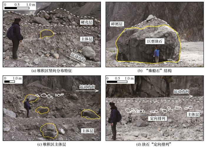
... 受冰川融水的侵蚀,堆积区内出露滑坡堆积剖面(图8 ).高速远程滑坡堆积体在竖向上主要呈现出三种相带:堆积体上部的硬壳层(carapace facies)、中部的主体层(body facies)以及下部的基底层(basal facies).硬壳层为堆积体剖面上最靠近顶端大块石富集的相带[11 ] .干河坝冰-岩碎屑流堆积区Ⅲ-2硬壳层主要由大块石组成[图8 (a)].其中,大多数巨石上表面“驮着”小石块(0.5~1 m)和细粒碎屑.该碎屑层主要由1~5 cm的灰岩碎石颗粒组成,呈棱角-次棱角状,崔之久[32 ] 称这种结构为“乘船石”[图8 (b)].该结构与在Blanc冰-岩碎屑流及Lamplugh冰-岩碎屑流堆积体中观察到一种小粒径颗粒“栖息”于巨型块石之上的结构十分相似[18 ,45 ] . ...
... 主体层是高速远程滑坡碎屑堆积的主要分布层位[11 ] .干河坝冰-岩碎屑流堆积区Ⅲ-2主体层多由2~5 cm的砾石组成,局部可见30~100 cm的块石,偶尔可观察到粒径大于1 m的巨石,基质主要由细粒(<0.075 mm)组成,呈灰白色[图8 (a), 8 (c)].除此外,平行于堆积体运动方向的堆积剖面上还可观察到部分块石的长轴延伸方向明显平行于运动方向[图8 (c)],局部还可以观察到块石的微倾斜状定向排列[图8 (d)]. ...
高速远程滑坡动力学研究进展
2
2021
... 受冰川融水的侵蚀,堆积区内出露滑坡堆积剖面(图8 ).高速远程滑坡堆积体在竖向上主要呈现出三种相带:堆积体上部的硬壳层(carapace facies)、中部的主体层(body facies)以及下部的基底层(basal facies).硬壳层为堆积体剖面上最靠近顶端大块石富集的相带[11 ] .干河坝冰-岩碎屑流堆积区Ⅲ-2硬壳层主要由大块石组成[图8 (a)].其中,大多数巨石上表面“驮着”小石块(0.5~1 m)和细粒碎屑.该碎屑层主要由1~5 cm的灰岩碎石颗粒组成,呈棱角-次棱角状,崔之久[32 ] 称这种结构为“乘船石”[图8 (b)].该结构与在Blanc冰-岩碎屑流及Lamplugh冰-岩碎屑流堆积体中观察到一种小粒径颗粒“栖息”于巨型块石之上的结构十分相似[18 ,45 ] . ...
... 主体层是高速远程滑坡碎屑堆积的主要分布层位[11 ] .干河坝冰-岩碎屑流堆积区Ⅲ-2主体层多由2~5 cm的砾石组成,局部可见30~100 cm的块石,偶尔可观察到粒径大于1 m的巨石,基质主要由细粒(<0.075 mm)组成,呈灰白色[图8 (a), 8 (c)].除此外,平行于堆积体运动方向的堆积剖面上还可观察到部分块石的长轴延伸方向明显平行于运动方向[图8 (c)],局部还可以观察到块石的微倾斜状定向排列[图8 (d)]. ...
Research progress on the morphology and sedimentology of long runout landslides
1
2021
... 高速远程滑坡相比于一般滑坡体积更大、运动速度更快、运动距离更远,并具有预测难、风险大的特点[10 -12 ] ,而冰-岩碎屑流一般展现出更低的等效摩擦系数和更远的运动距离[6 ,13 -15 ] .近年来,在全球范围内,许多针对冰-岩碎屑流沉积学和运动学的研究正在进行.Hewitt[16 -17 ] 指出了冰-岩碎屑流呈现出堆积体厚度较薄,多呈叶状或者舌状的特点,并广泛发育着丘体、纵向脊、横向脊、流带等堆积地貌特征.杨情情等[5 ] 在易贡滑坡堆积体前端发现有因冰屑融化形成的深0.5~4.5 m的坑洞;Deline[18 ] 在Miage冰-岩碎屑流堆积体中观察到不规则的隆起洼地(irregular hills and depressions);Sosio等[14 ,19 ] 则在Thurwieser冰-岩碎屑流堆积体前端3~4 km处发现由细粒物质组成的薄层粉末(thin layers of dust).这些研究表明了冰-岩碎屑流与其他高速远程滑坡相比既存在共性,也存在差异.Schneider等[4 ] 指出,相比普通高速远程滑坡,冰-岩碎屑流的运动特性显著受到了冰水含量的影响.不少学者通过室内试验和数值模拟的方式研究含冰量、下伏层冰川和冰融水对冰-岩混合材料运动性的影响机理,目前主要有以下几种观点:(1)冰川地区下伏层摩擦力较小,比岩层更易铲刮,碎屑物质在其上运动时运动性更强[19 -21 ] .(2)碎屑流中的冰雪物质可减少岩体碎屑之间的内部摩擦耗能[22 -23 ] ;(3)碎屑流基底冰屑物质因摩擦加热导致基底物质饱和,降低了流动阻力[24 -26 ] .正是由于冰-岩碎屑流在形成过程中存在着固体(岩石和冰)和液体(水、雪、泥浆和细颗粒)的动态相互作用,使得冰-岩碎屑流滑坡的运动过程和堆积结构更加复杂[27 -28 ] . ...
高速远程滑坡的地貌学与沉积学研究进展
1
2021
... 高速远程滑坡相比于一般滑坡体积更大、运动速度更快、运动距离更远,并具有预测难、风险大的特点[10 -12 ] ,而冰-岩碎屑流一般展现出更低的等效摩擦系数和更远的运动距离[6 ,13 -15 ] .近年来,在全球范围内,许多针对冰-岩碎屑流沉积学和运动学的研究正在进行.Hewitt[16 -17 ] 指出了冰-岩碎屑流呈现出堆积体厚度较薄,多呈叶状或者舌状的特点,并广泛发育着丘体、纵向脊、横向脊、流带等堆积地貌特征.杨情情等[5 ] 在易贡滑坡堆积体前端发现有因冰屑融化形成的深0.5~4.5 m的坑洞;Deline[18 ] 在Miage冰-岩碎屑流堆积体中观察到不规则的隆起洼地(irregular hills and depressions);Sosio等[14 ,19 ] 则在Thurwieser冰-岩碎屑流堆积体前端3~4 km处发现由细粒物质组成的薄层粉末(thin layers of dust).这些研究表明了冰-岩碎屑流与其他高速远程滑坡相比既存在共性,也存在差异.Schneider等[4 ] 指出,相比普通高速远程滑坡,冰-岩碎屑流的运动特性显著受到了冰水含量的影响.不少学者通过室内试验和数值模拟的方式研究含冰量、下伏层冰川和冰融水对冰-岩混合材料运动性的影响机理,目前主要有以下几种观点:(1)冰川地区下伏层摩擦力较小,比岩层更易铲刮,碎屑物质在其上运动时运动性更强[19 -21 ] .(2)碎屑流中的冰雪物质可减少岩体碎屑之间的内部摩擦耗能[22 -23 ] ;(3)碎屑流基底冰屑物质因摩擦加热导致基底物质饱和,降低了流动阻力[24 -26 ] .正是由于冰-岩碎屑流在形成过程中存在着固体(岩石和冰)和液体(水、雪、泥浆和细颗粒)的动态相互作用,使得冰-岩碎屑流滑坡的运动过程和堆积结构更加复杂[27 -28 ] . ...
Catastrophic rock avalanches in glacial environments
1
1989
... 高速远程滑坡相比于一般滑坡体积更大、运动速度更快、运动距离更远,并具有预测难、风险大的特点[10 -12 ] ,而冰-岩碎屑流一般展现出更低的等效摩擦系数和更远的运动距离[6 ,13 -15 ] .近年来,在全球范围内,许多针对冰-岩碎屑流沉积学和运动学的研究正在进行.Hewitt[16 -17 ] 指出了冰-岩碎屑流呈现出堆积体厚度较薄,多呈叶状或者舌状的特点,并广泛发育着丘体、纵向脊、横向脊、流带等堆积地貌特征.杨情情等[5 ] 在易贡滑坡堆积体前端发现有因冰屑融化形成的深0.5~4.5 m的坑洞;Deline[18 ] 在Miage冰-岩碎屑流堆积体中观察到不规则的隆起洼地(irregular hills and depressions);Sosio等[14 ,19 ] 则在Thurwieser冰-岩碎屑流堆积体前端3~4 km处发现由细粒物质组成的薄层粉末(thin layers of dust).这些研究表明了冰-岩碎屑流与其他高速远程滑坡相比既存在共性,也存在差异.Schneider等[4 ] 指出,相比普通高速远程滑坡,冰-岩碎屑流的运动特性显著受到了冰水含量的影响.不少学者通过室内试验和数值模拟的方式研究含冰量、下伏层冰川和冰融水对冰-岩混合材料运动性的影响机理,目前主要有以下几种观点:(1)冰川地区下伏层摩擦力较小,比岩层更易铲刮,碎屑物质在其上运动时运动性更强[19 -21 ] .(2)碎屑流中的冰雪物质可减少岩体碎屑之间的内部摩擦耗能[22 -23 ] ;(3)碎屑流基底冰屑物质因摩擦加热导致基底物质饱和,降低了流动阻力[24 -26 ] .正是由于冰-岩碎屑流在形成过程中存在着固体(岩石和冰)和液体(水、雪、泥浆和细颗粒)的动态相互作用,使得冰-岩碎屑流滑坡的运动过程和堆积结构更加复杂[27 -28 ] . ...
Complete dynamic modeling calibration for the Thurwieser rock avalanche (Italian Central Alps)
1
2008
... 高速远程滑坡相比于一般滑坡体积更大、运动速度更快、运动距离更远,并具有预测难、风险大的特点[10 -12 ] ,而冰-岩碎屑流一般展现出更低的等效摩擦系数和更远的运动距离[6 ,13 -15 ] .近年来,在全球范围内,许多针对冰-岩碎屑流沉积学和运动学的研究正在进行.Hewitt[16 -17 ] 指出了冰-岩碎屑流呈现出堆积体厚度较薄,多呈叶状或者舌状的特点,并广泛发育着丘体、纵向脊、横向脊、流带等堆积地貌特征.杨情情等[5 ] 在易贡滑坡堆积体前端发现有因冰屑融化形成的深0.5~4.5 m的坑洞;Deline[18 ] 在Miage冰-岩碎屑流堆积体中观察到不规则的隆起洼地(irregular hills and depressions);Sosio等[14 ,19 ] 则在Thurwieser冰-岩碎屑流堆积体前端3~4 km处发现由细粒物质组成的薄层粉末(thin layers of dust).这些研究表明了冰-岩碎屑流与其他高速远程滑坡相比既存在共性,也存在差异.Schneider等[4 ] 指出,相比普通高速远程滑坡,冰-岩碎屑流的运动特性显著受到了冰水含量的影响.不少学者通过室内试验和数值模拟的方式研究含冰量、下伏层冰川和冰融水对冰-岩混合材料运动性的影响机理,目前主要有以下几种观点:(1)冰川地区下伏层摩擦力较小,比岩层更易铲刮,碎屑物质在其上运动时运动性更强[19 -21 ] .(2)碎屑流中的冰雪物质可减少岩体碎屑之间的内部摩擦耗能[22 -23 ] ;(3)碎屑流基底冰屑物质因摩擦加热导致基底物质饱和,降低了流动阻力[24 -26 ] .正是由于冰-岩碎屑流在形成过程中存在着固体(岩石和冰)和液体(水、雪、泥浆和细颗粒)的动态相互作用,使得冰-岩碎屑流滑坡的运动过程和堆积结构更加复杂[27 -28 ] . ...
Rock-snow-ice avalanches
1
2015
... 高速远程滑坡相比于一般滑坡体积更大、运动速度更快、运动距离更远,并具有预测难、风险大的特点[10 -12 ] ,而冰-岩碎屑流一般展现出更低的等效摩擦系数和更远的运动距离[6 ,13 -15 ] .近年来,在全球范围内,许多针对冰-岩碎屑流沉积学和运动学的研究正在进行.Hewitt[16 -17 ] 指出了冰-岩碎屑流呈现出堆积体厚度较薄,多呈叶状或者舌状的特点,并广泛发育着丘体、纵向脊、横向脊、流带等堆积地貌特征.杨情情等[5 ] 在易贡滑坡堆积体前端发现有因冰屑融化形成的深0.5~4.5 m的坑洞;Deline[18 ] 在Miage冰-岩碎屑流堆积体中观察到不规则的隆起洼地(irregular hills and depressions);Sosio等[14 ,19 ] 则在Thurwieser冰-岩碎屑流堆积体前端3~4 km处发现由细粒物质组成的薄层粉末(thin layers of dust).这些研究表明了冰-岩碎屑流与其他高速远程滑坡相比既存在共性,也存在差异.Schneider等[4 ] 指出,相比普通高速远程滑坡,冰-岩碎屑流的运动特性显著受到了冰水含量的影响.不少学者通过室内试验和数值模拟的方式研究含冰量、下伏层冰川和冰融水对冰-岩混合材料运动性的影响机理,目前主要有以下几种观点:(1)冰川地区下伏层摩擦力较小,比岩层更易铲刮,碎屑物质在其上运动时运动性更强[19 -21 ] .(2)碎屑流中的冰雪物质可减少岩体碎屑之间的内部摩擦耗能[22 -23 ] ;(3)碎屑流基底冰屑物质因摩擦加热导致基底物质饱和,降低了流动阻力[24 -26 ] .正是由于冰-岩碎屑流在形成过程中存在着固体(岩石和冰)和液体(水、雪、泥浆和细颗粒)的动态相互作用,使得冰-岩碎屑流滑坡的运动过程和堆积结构更加复杂[27 -28 ] . ...
Catastrophic landslide deposits in the Karakoram Himalaya
1
1988
... 高速远程滑坡相比于一般滑坡体积更大、运动速度更快、运动距离更远,并具有预测难、风险大的特点[10 -12 ] ,而冰-岩碎屑流一般展现出更低的等效摩擦系数和更远的运动距离[6 ,13 -15 ] .近年来,在全球范围内,许多针对冰-岩碎屑流沉积学和运动学的研究正在进行.Hewitt[16 -17 ] 指出了冰-岩碎屑流呈现出堆积体厚度较薄,多呈叶状或者舌状的特点,并广泛发育着丘体、纵向脊、横向脊、流带等堆积地貌特征.杨情情等[5 ] 在易贡滑坡堆积体前端发现有因冰屑融化形成的深0.5~4.5 m的坑洞;Deline[18 ] 在Miage冰-岩碎屑流堆积体中观察到不规则的隆起洼地(irregular hills and depressions);Sosio等[14 ,19 ] 则在Thurwieser冰-岩碎屑流堆积体前端3~4 km处发现由细粒物质组成的薄层粉末(thin layers of dust).这些研究表明了冰-岩碎屑流与其他高速远程滑坡相比既存在共性,也存在差异.Schneider等[4 ] 指出,相比普通高速远程滑坡,冰-岩碎屑流的运动特性显著受到了冰水含量的影响.不少学者通过室内试验和数值模拟的方式研究含冰量、下伏层冰川和冰融水对冰-岩混合材料运动性的影响机理,目前主要有以下几种观点:(1)冰川地区下伏层摩擦力较小,比岩层更易铲刮,碎屑物质在其上运动时运动性更强[19 -21 ] .(2)碎屑流中的冰雪物质可减少岩体碎屑之间的内部摩擦耗能[22 -23 ] ;(3)碎屑流基底冰屑物质因摩擦加热导致基底物质饱和,降低了流动阻力[24 -26 ] .正是由于冰-岩碎屑流在形成过程中存在着固体(岩石和冰)和液体(水、雪、泥浆和细颗粒)的动态相互作用,使得冰-岩碎屑流滑坡的运动过程和堆积结构更加复杂[27 -28 ] . ...
Quaternary moraines vs catastrophic rock avalanches in the Karakoram Himalaya, northern Pakistan
1
1999
... 高速远程滑坡相比于一般滑坡体积更大、运动速度更快、运动距离更远,并具有预测难、风险大的特点[10 -12 ] ,而冰-岩碎屑流一般展现出更低的等效摩擦系数和更远的运动距离[6 ,13 -15 ] .近年来,在全球范围内,许多针对冰-岩碎屑流沉积学和运动学的研究正在进行.Hewitt[16 -17 ] 指出了冰-岩碎屑流呈现出堆积体厚度较薄,多呈叶状或者舌状的特点,并广泛发育着丘体、纵向脊、横向脊、流带等堆积地貌特征.杨情情等[5 ] 在易贡滑坡堆积体前端发现有因冰屑融化形成的深0.5~4.5 m的坑洞;Deline[18 ] 在Miage冰-岩碎屑流堆积体中观察到不规则的隆起洼地(irregular hills and depressions);Sosio等[14 ,19 ] 则在Thurwieser冰-岩碎屑流堆积体前端3~4 km处发现由细粒物质组成的薄层粉末(thin layers of dust).这些研究表明了冰-岩碎屑流与其他高速远程滑坡相比既存在共性,也存在差异.Schneider等[4 ] 指出,相比普通高速远程滑坡,冰-岩碎屑流的运动特性显著受到了冰水含量的影响.不少学者通过室内试验和数值模拟的方式研究含冰量、下伏层冰川和冰融水对冰-岩混合材料运动性的影响机理,目前主要有以下几种观点:(1)冰川地区下伏层摩擦力较小,比岩层更易铲刮,碎屑物质在其上运动时运动性更强[19 -21 ] .(2)碎屑流中的冰雪物质可减少岩体碎屑之间的内部摩擦耗能[22 -23 ] ;(3)碎屑流基底冰屑物质因摩擦加热导致基底物质饱和,降低了流动阻力[24 -26 ] .正是由于冰-岩碎屑流在形成过程中存在着固体(岩石和冰)和液体(水、雪、泥浆和细颗粒)的动态相互作用,使得冰-岩碎屑流滑坡的运动过程和堆积结构更加复杂[27 -28 ] . ...
Interactions between rock avalanches and glaciers in the Mont Blanc massif during the late Holocene
4
2009
... 高速远程滑坡相比于一般滑坡体积更大、运动速度更快、运动距离更远,并具有预测难、风险大的特点[10 -12 ] ,而冰-岩碎屑流一般展现出更低的等效摩擦系数和更远的运动距离[6 ,13 -15 ] .近年来,在全球范围内,许多针对冰-岩碎屑流沉积学和运动学的研究正在进行.Hewitt[16 -17 ] 指出了冰-岩碎屑流呈现出堆积体厚度较薄,多呈叶状或者舌状的特点,并广泛发育着丘体、纵向脊、横向脊、流带等堆积地貌特征.杨情情等[5 ] 在易贡滑坡堆积体前端发现有因冰屑融化形成的深0.5~4.5 m的坑洞;Deline[18 ] 在Miage冰-岩碎屑流堆积体中观察到不规则的隆起洼地(irregular hills and depressions);Sosio等[14 ,19 ] 则在Thurwieser冰-岩碎屑流堆积体前端3~4 km处发现由细粒物质组成的薄层粉末(thin layers of dust).这些研究表明了冰-岩碎屑流与其他高速远程滑坡相比既存在共性,也存在差异.Schneider等[4 ] 指出,相比普通高速远程滑坡,冰-岩碎屑流的运动特性显著受到了冰水含量的影响.不少学者通过室内试验和数值模拟的方式研究含冰量、下伏层冰川和冰融水对冰-岩混合材料运动性的影响机理,目前主要有以下几种观点:(1)冰川地区下伏层摩擦力较小,比岩层更易铲刮,碎屑物质在其上运动时运动性更强[19 -21 ] .(2)碎屑流中的冰雪物质可减少岩体碎屑之间的内部摩擦耗能[22 -23 ] ;(3)碎屑流基底冰屑物质因摩擦加热导致基底物质饱和,降低了流动阻力[24 -26 ] .正是由于冰-岩碎屑流在形成过程中存在着固体(岩石和冰)和液体(水、雪、泥浆和细颗粒)的动态相互作用,使得冰-岩碎屑流滑坡的运动过程和堆积结构更加复杂[27 -28 ] . ...
... 杨情情等[6 ] 在梳理全球冰-岩碎屑流灾害分布时,指出了喜马拉雅-喀喇昆仑山脉灾难性冰-岩碎屑流频发.然而,当前国内关于冰-岩碎屑流的案例研究还很少[29 -30 ] .2004年3月12日,云南省丽江市玉龙雪山南坡发生了剧烈的冰-岩崩塌-碎屑流[20 ] .玉龙雪山地处青藏高原最南端的海洋型冰川区,该区冰-岩碎屑流的发育对我国气候变化下冰川灾害链的研究具有重要意义.此外,玉龙雪山为我国国家级风景名胜区,日游客接待量最高可达5万余人,若冰-岩碎屑流再次发生,很可能会威胁该区游客的生命安全,并迅速改造当地地貌环境[18 ] ,影响该地区的水循环过程,进而影响当地的经济发展[31 ] .崔之久于2007年4月8日对干河坝滑坡进行过初步调查[32 ] ,研究团队于2021年4月27日开展了进一步详细的野外调查工作,判断此事件为冰-岩碎屑流滑坡.本文将通过遥感影像分析、野外调查等手段,研究干河坝冰-岩碎屑流的地貌与堆积特征,反演其运动学过程,在此基础上探讨其超强运动机理,以期进一步加深对冰-岩碎屑流滑坡运动特征的认识,为玉龙雪山乃至青藏高原其他地区类似灾害的预测与防控提供科学依据. ...
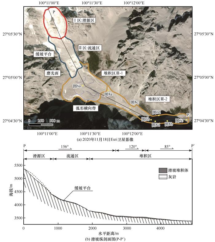
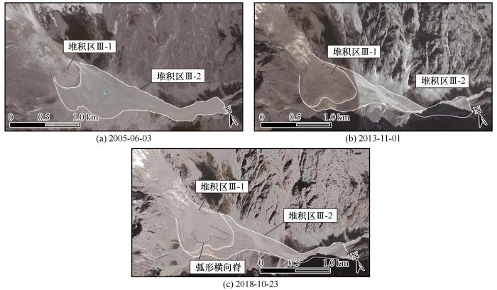
... 堆积区(Ⅲ区)长约2 860 m,海拔高度位于3 379 m至3 712 m之间,可分为Ⅲ-1区和Ⅲ-2区[图3 (a)].二者堆积体厚度具有明显差异,这与Blanc冰-岩碎屑流和Frebouge冰-岩碎屑流表现出的局部堆积体富集的特征相似[18 ,42 ] . ...
... 受冰川融水的侵蚀,堆积区内出露滑坡堆积剖面(图8 ).高速远程滑坡堆积体在竖向上主要呈现出三种相带:堆积体上部的硬壳层(carapace facies)、中部的主体层(body facies)以及下部的基底层(basal facies).硬壳层为堆积体剖面上最靠近顶端大块石富集的相带[11 ] .干河坝冰-岩碎屑流堆积区Ⅲ-2硬壳层主要由大块石组成[图8 (a)].其中,大多数巨石上表面“驮着”小石块(0.5~1 m)和细粒碎屑.该碎屑层主要由1~5 cm的灰岩碎石颗粒组成,呈棱角-次棱角状,崔之久[32 ] 称这种结构为“乘船石”[图8 (b)].该结构与在Blanc冰-岩碎屑流及Lamplugh冰-岩碎屑流堆积体中观察到一种小粒径颗粒“栖息”于巨型块石之上的结构十分相似[18 ,45 ] . ...
Modelling rock avalanche propagation onto glaciers
4
2012
... 高速远程滑坡相比于一般滑坡体积更大、运动速度更快、运动距离更远,并具有预测难、风险大的特点[10 -12 ] ,而冰-岩碎屑流一般展现出更低的等效摩擦系数和更远的运动距离[6 ,13 -15 ] .近年来,在全球范围内,许多针对冰-岩碎屑流沉积学和运动学的研究正在进行.Hewitt[16 -17 ] 指出了冰-岩碎屑流呈现出堆积体厚度较薄,多呈叶状或者舌状的特点,并广泛发育着丘体、纵向脊、横向脊、流带等堆积地貌特征.杨情情等[5 ] 在易贡滑坡堆积体前端发现有因冰屑融化形成的深0.5~4.5 m的坑洞;Deline[18 ] 在Miage冰-岩碎屑流堆积体中观察到不规则的隆起洼地(irregular hills and depressions);Sosio等[14 ,19 ] 则在Thurwieser冰-岩碎屑流堆积体前端3~4 km处发现由细粒物质组成的薄层粉末(thin layers of dust).这些研究表明了冰-岩碎屑流与其他高速远程滑坡相比既存在共性,也存在差异.Schneider等[4 ] 指出,相比普通高速远程滑坡,冰-岩碎屑流的运动特性显著受到了冰水含量的影响.不少学者通过室内试验和数值模拟的方式研究含冰量、下伏层冰川和冰融水对冰-岩混合材料运动性的影响机理,目前主要有以下几种观点:(1)冰川地区下伏层摩擦力较小,比岩层更易铲刮,碎屑物质在其上运动时运动性更强[19 -21 ] .(2)碎屑流中的冰雪物质可减少岩体碎屑之间的内部摩擦耗能[22 -23 ] ;(3)碎屑流基底冰屑物质因摩擦加热导致基底物质饱和,降低了流动阻力[24 -26 ] .正是由于冰-岩碎屑流在形成过程中存在着固体(岩石和冰)和液体(水、雪、泥浆和细颗粒)的动态相互作用,使得冰-岩碎屑流滑坡的运动过程和堆积结构更加复杂[27 -28 ] . ...
... [19 -21 ].(2)碎屑流中的冰雪物质可减少岩体碎屑之间的内部摩擦耗能[22 -23 ] ;(3)碎屑流基底冰屑物质因摩擦加热导致基底物质饱和,降低了流动阻力[24 -26 ] .正是由于冰-岩碎屑流在形成过程中存在着固体(岩石和冰)和液体(水、雪、泥浆和细颗粒)的动态相互作用,使得冰-岩碎屑流滑坡的运动过程和堆积结构更加复杂[27 -28 ] . ...
... Storm等[58 ] 以中亚地区433个高速远程滑坡为例,根据地形条件的不同将其分为正向受限型(Frontally confined)、侧向受限型(Laterally confined)和非约束型(Unconfined)三类,分别建立了影响面积(滑坡区总面积A t o t a l A d e p V )、高差(H m a x [19 ] 以42个地区的冰-岩碎屑流为例,建立了滑体体积(V )与堆积区面积(A )的公式(表3 ).作为一种侧向受限型冰-岩碎屑流,将干河坝滑坡的滑体体积(V =0.0091 k m 3 H m a x = 1.971 k m 表3 的拟合公式中可得到其影响面积的计算值.通过对比可知其计算值均大于实测值,这说明与相同体积、类似高差的高速远程滑坡相比,干河坝冰-岩碎屑流的影响面积偏小.由此可知,干河坝冰-岩碎屑流的运动性相对较弱,本文认为这与干河坝滑坡区特殊的地形条件有关. ...
... Regression equations and evaluations of the parameters of the Ganheba rock-ice avalanche
Table 3 计算公式 拟合度 实测值 计算值 文献来源 A t o t a l = 10 1.0884 V H m a x 0.5497 0.927 1.32 k m 2 1.34 k m 2 Storm et al, 2019[58 ] A d e p = 10 0.9748 V H m a x 0.5745 0.915 0.89 k m 2 1.06 k m 2 V = 2.60 A 0.86 0.74 0.89 k m 2 5.46 k m 2 Sosio et al, 2012[19 ]
首先,源区灰岩节理裂隙发育,滑体运动至缓坡平台时,与下伏基岩发生剧烈撞击,颗粒与颗粒之间内部剪切和碰撞剧烈.根据Manzella等[59 -60 ] ,与完整滑体相比,高度破碎的失稳岩体在运动过程中因内部剪切和碰撞耗能,进入堆积区时速度较小.因此,推测干河坝冰-岩碎屑流滑体与流通区的缓坡平台在撞击过程中耗散了大量能量,降低了堆积区碎屑流的初始运动速度. ...
Modelling rock avalanches and their relation to permafrost degradation in glacial environments
1
2002
... 杨情情等[6 ] 在梳理全球冰-岩碎屑流灾害分布时,指出了喜马拉雅-喀喇昆仑山脉灾难性冰-岩碎屑流频发.然而,当前国内关于冰-岩碎屑流的案例研究还很少[29 -30 ] .2004年3月12日,云南省丽江市玉龙雪山南坡发生了剧烈的冰-岩崩塌-碎屑流[20 ] .玉龙雪山地处青藏高原最南端的海洋型冰川区,该区冰-岩碎屑流的发育对我国气候变化下冰川灾害链的研究具有重要意义.此外,玉龙雪山为我国国家级风景名胜区,日游客接待量最高可达5万余人,若冰-岩碎屑流再次发生,很可能会威胁该区游客的生命安全,并迅速改造当地地貌环境[18 ] ,影响该地区的水循环过程,进而影响当地的经济发展[31 ] .崔之久于2007年4月8日对干河坝滑坡进行过初步调查[32 ] ,研究团队于2021年4月27日开展了进一步详细的野外调查工作,判断此事件为冰-岩碎屑流滑坡.本文将通过遥感影像分析、野外调查等手段,研究干河坝冰-岩碎屑流的地貌与堆积特征,反演其运动学过程,在此基础上探讨其超强运动机理,以期进一步加深对冰-岩碎屑流滑坡运动特征的认识,为玉龙雪山乃至青藏高原其他地区类似灾害的预测与防控提供科学依据. ...
The 1997 Mount Munday landslide (British Columbia) and the behaviour of rock avalanches on glacier surfaces
1
2014
... 高速远程滑坡相比于一般滑坡体积更大、运动速度更快、运动距离更远,并具有预测难、风险大的特点[10 -12 ] ,而冰-岩碎屑流一般展现出更低的等效摩擦系数和更远的运动距离[6 ,13 -15 ] .近年来,在全球范围内,许多针对冰-岩碎屑流沉积学和运动学的研究正在进行.Hewitt[16 -17 ] 指出了冰-岩碎屑流呈现出堆积体厚度较薄,多呈叶状或者舌状的特点,并广泛发育着丘体、纵向脊、横向脊、流带等堆积地貌特征.杨情情等[5 ] 在易贡滑坡堆积体前端发现有因冰屑融化形成的深0.5~4.5 m的坑洞;Deline[18 ] 在Miage冰-岩碎屑流堆积体中观察到不规则的隆起洼地(irregular hills and depressions);Sosio等[14 ,19 ] 则在Thurwieser冰-岩碎屑流堆积体前端3~4 km处发现由细粒物质组成的薄层粉末(thin layers of dust).这些研究表明了冰-岩碎屑流与其他高速远程滑坡相比既存在共性,也存在差异.Schneider等[4 ] 指出,相比普通高速远程滑坡,冰-岩碎屑流的运动特性显著受到了冰水含量的影响.不少学者通过室内试验和数值模拟的方式研究含冰量、下伏层冰川和冰融水对冰-岩混合材料运动性的影响机理,目前主要有以下几种观点:(1)冰川地区下伏层摩擦力较小,比岩层更易铲刮,碎屑物质在其上运动时运动性更强[19 -21 ] .(2)碎屑流中的冰雪物质可减少岩体碎屑之间的内部摩擦耗能[22 -23 ] ;(3)碎屑流基底冰屑物质因摩擦加热导致基底物质饱和,降低了流动阻力[24 -26 ] .正是由于冰-岩碎屑流在形成过程中存在着固体(岩石和冰)和液体(水、雪、泥浆和细颗粒)的动态相互作用,使得冰-岩碎屑流滑坡的运动过程和堆积结构更加复杂[27 -28 ] . ...
Frictional behavior of granular gravel-ice mixtures in vertically rotating drum experiments and implications for rock-ice avalanches
1
2011
... 高速远程滑坡相比于一般滑坡体积更大、运动速度更快、运动距离更远,并具有预测难、风险大的特点[10 -12 ] ,而冰-岩碎屑流一般展现出更低的等效摩擦系数和更远的运动距离[6 ,13 -15 ] .近年来,在全球范围内,许多针对冰-岩碎屑流沉积学和运动学的研究正在进行.Hewitt[16 -17 ] 指出了冰-岩碎屑流呈现出堆积体厚度较薄,多呈叶状或者舌状的特点,并广泛发育着丘体、纵向脊、横向脊、流带等堆积地貌特征.杨情情等[5 ] 在易贡滑坡堆积体前端发现有因冰屑融化形成的深0.5~4.5 m的坑洞;Deline[18 ] 在Miage冰-岩碎屑流堆积体中观察到不规则的隆起洼地(irregular hills and depressions);Sosio等[14 ,19 ] 则在Thurwieser冰-岩碎屑流堆积体前端3~4 km处发现由细粒物质组成的薄层粉末(thin layers of dust).这些研究表明了冰-岩碎屑流与其他高速远程滑坡相比既存在共性,也存在差异.Schneider等[4 ] 指出,相比普通高速远程滑坡,冰-岩碎屑流的运动特性显著受到了冰水含量的影响.不少学者通过室内试验和数值模拟的方式研究含冰量、下伏层冰川和冰融水对冰-岩混合材料运动性的影响机理,目前主要有以下几种观点:(1)冰川地区下伏层摩擦力较小,比岩层更易铲刮,碎屑物质在其上运动时运动性更强[19 -21 ] .(2)碎屑流中的冰雪物质可减少岩体碎屑之间的内部摩擦耗能[22 -23 ] ;(3)碎屑流基底冰屑物质因摩擦加热导致基底物质饱和,降低了流动阻力[24 -26 ] .正是由于冰-岩碎屑流在形成过程中存在着固体(岩石和冰)和液体(水、雪、泥浆和细颗粒)的动态相互作用,使得冰-岩碎屑流滑坡的运动过程和堆积结构更加复杂[27 -28 ] . ...
High mobility of rock-ice avalanches: insights from small flume tests of gravel-ice mixtures
1
2019
... 高速远程滑坡相比于一般滑坡体积更大、运动速度更快、运动距离更远,并具有预测难、风险大的特点[10 -12 ] ,而冰-岩碎屑流一般展现出更低的等效摩擦系数和更远的运动距离[6 ,13 -15 ] .近年来,在全球范围内,许多针对冰-岩碎屑流沉积学和运动学的研究正在进行.Hewitt[16 -17 ] 指出了冰-岩碎屑流呈现出堆积体厚度较薄,多呈叶状或者舌状的特点,并广泛发育着丘体、纵向脊、横向脊、流带等堆积地貌特征.杨情情等[5 ] 在易贡滑坡堆积体前端发现有因冰屑融化形成的深0.5~4.5 m的坑洞;Deline[18 ] 在Miage冰-岩碎屑流堆积体中观察到不规则的隆起洼地(irregular hills and depressions);Sosio等[14 ,19 ] 则在Thurwieser冰-岩碎屑流堆积体前端3~4 km处发现由细粒物质组成的薄层粉末(thin layers of dust).这些研究表明了冰-岩碎屑流与其他高速远程滑坡相比既存在共性,也存在差异.Schneider等[4 ] 指出,相比普通高速远程滑坡,冰-岩碎屑流的运动特性显著受到了冰水含量的影响.不少学者通过室内试验和数值模拟的方式研究含冰量、下伏层冰川和冰融水对冰-岩混合材料运动性的影响机理,目前主要有以下几种观点:(1)冰川地区下伏层摩擦力较小,比岩层更易铲刮,碎屑物质在其上运动时运动性更强[19 -21 ] .(2)碎屑流中的冰雪物质可减少岩体碎屑之间的内部摩擦耗能[22 -23 ] ;(3)碎屑流基底冰屑物质因摩擦加热导致基底物质饱和,降低了流动阻力[24 -26 ] .正是由于冰-岩碎屑流在形成过程中存在着固体(岩石和冰)和液体(水、雪、泥浆和细颗粒)的动态相互作用,使得冰-岩碎屑流滑坡的运动过程和堆积结构更加复杂[27 -28 ] . ...
Friction and dynamics of rock avalanches travelling on glaciers
1
2014
... 高速远程滑坡相比于一般滑坡体积更大、运动速度更快、运动距离更远,并具有预测难、风险大的特点[10 -12 ] ,而冰-岩碎屑流一般展现出更低的等效摩擦系数和更远的运动距离[6 ,13 -15 ] .近年来,在全球范围内,许多针对冰-岩碎屑流沉积学和运动学的研究正在进行.Hewitt[16 -17 ] 指出了冰-岩碎屑流呈现出堆积体厚度较薄,多呈叶状或者舌状的特点,并广泛发育着丘体、纵向脊、横向脊、流带等堆积地貌特征.杨情情等[5 ] 在易贡滑坡堆积体前端发现有因冰屑融化形成的深0.5~4.5 m的坑洞;Deline[18 ] 在Miage冰-岩碎屑流堆积体中观察到不规则的隆起洼地(irregular hills and depressions);Sosio等[14 ,19 ] 则在Thurwieser冰-岩碎屑流堆积体前端3~4 km处发现由细粒物质组成的薄层粉末(thin layers of dust).这些研究表明了冰-岩碎屑流与其他高速远程滑坡相比既存在共性,也存在差异.Schneider等[4 ] 指出,相比普通高速远程滑坡,冰-岩碎屑流的运动特性显著受到了冰水含量的影响.不少学者通过室内试验和数值模拟的方式研究含冰量、下伏层冰川和冰融水对冰-岩混合材料运动性的影响机理,目前主要有以下几种观点:(1)冰川地区下伏层摩擦力较小,比岩层更易铲刮,碎屑物质在其上运动时运动性更强[19 -21 ] .(2)碎屑流中的冰雪物质可减少岩体碎屑之间的内部摩擦耗能[22 -23 ] ;(3)碎屑流基底冰屑物质因摩擦加热导致基底物质饱和,降低了流动阻力[24 -26 ] .正是由于冰-岩碎屑流在形成过程中存在着固体(岩石和冰)和液体(水、雪、泥浆和细颗粒)的动态相互作用,使得冰-岩碎屑流滑坡的运动过程和堆积结构更加复杂[27 -28 ] . ...
Sherman glacier rock avalanche, Alaska, U.S.A.
0
1978
Recent rockfalls and rock avalanches in Mount Cook National Park, New Zealand
1
2002
... 高速远程滑坡相比于一般滑坡体积更大、运动速度更快、运动距离更远,并具有预测难、风险大的特点[10 -12 ] ,而冰-岩碎屑流一般展现出更低的等效摩擦系数和更远的运动距离[6 ,13 -15 ] .近年来,在全球范围内,许多针对冰-岩碎屑流沉积学和运动学的研究正在进行.Hewitt[16 -17 ] 指出了冰-岩碎屑流呈现出堆积体厚度较薄,多呈叶状或者舌状的特点,并广泛发育着丘体、纵向脊、横向脊、流带等堆积地貌特征.杨情情等[5 ] 在易贡滑坡堆积体前端发现有因冰屑融化形成的深0.5~4.5 m的坑洞;Deline[18 ] 在Miage冰-岩碎屑流堆积体中观察到不规则的隆起洼地(irregular hills and depressions);Sosio等[14 ,19 ] 则在Thurwieser冰-岩碎屑流堆积体前端3~4 km处发现由细粒物质组成的薄层粉末(thin layers of dust).这些研究表明了冰-岩碎屑流与其他高速远程滑坡相比既存在共性,也存在差异.Schneider等[4 ] 指出,相比普通高速远程滑坡,冰-岩碎屑流的运动特性显著受到了冰水含量的影响.不少学者通过室内试验和数值模拟的方式研究含冰量、下伏层冰川和冰融水对冰-岩混合材料运动性的影响机理,目前主要有以下几种观点:(1)冰川地区下伏层摩擦力较小,比岩层更易铲刮,碎屑物质在其上运动时运动性更强[19 -21 ] .(2)碎屑流中的冰雪物质可减少岩体碎屑之间的内部摩擦耗能[22 -23 ] ;(3)碎屑流基底冰屑物质因摩擦加热导致基底物质饱和,降低了流动阻力[24 -26 ] .正是由于冰-岩碎屑流在形成过程中存在着固体(岩石和冰)和液体(水、雪、泥浆和细颗粒)的动态相互作用,使得冰-岩碎屑流滑坡的运动过程和堆积结构更加复杂[27 -28 ] . ...
Catastrophic mass flows in the mountain glacial environment
1
2015
... 高速远程滑坡相比于一般滑坡体积更大、运动速度更快、运动距离更远,并具有预测难、风险大的特点[10 -12 ] ,而冰-岩碎屑流一般展现出更低的等效摩擦系数和更远的运动距离[6 ,13 -15 ] .近年来,在全球范围内,许多针对冰-岩碎屑流沉积学和运动学的研究正在进行.Hewitt[16 -17 ] 指出了冰-岩碎屑流呈现出堆积体厚度较薄,多呈叶状或者舌状的特点,并广泛发育着丘体、纵向脊、横向脊、流带等堆积地貌特征.杨情情等[5 ] 在易贡滑坡堆积体前端发现有因冰屑融化形成的深0.5~4.5 m的坑洞;Deline[18 ] 在Miage冰-岩碎屑流堆积体中观察到不规则的隆起洼地(irregular hills and depressions);Sosio等[14 ,19 ] 则在Thurwieser冰-岩碎屑流堆积体前端3~4 km处发现由细粒物质组成的薄层粉末(thin layers of dust).这些研究表明了冰-岩碎屑流与其他高速远程滑坡相比既存在共性,也存在差异.Schneider等[4 ] 指出,相比普通高速远程滑坡,冰-岩碎屑流的运动特性显著受到了冰水含量的影响.不少学者通过室内试验和数值模拟的方式研究含冰量、下伏层冰川和冰融水对冰-岩混合材料运动性的影响机理,目前主要有以下几种观点:(1)冰川地区下伏层摩擦力较小,比岩层更易铲刮,碎屑物质在其上运动时运动性更强[19 -21 ] .(2)碎屑流中的冰雪物质可减少岩体碎屑之间的内部摩擦耗能[22 -23 ] ;(3)碎屑流基底冰屑物质因摩擦加热导致基底物质饱和,降低了流动阻力[24 -26 ] .正是由于冰-岩碎屑流在形成过程中存在着固体(岩石和冰)和液体(水、雪、泥浆和细颗粒)的动态相互作用,使得冰-岩碎屑流滑坡的运动过程和堆积结构更加复杂[27 -28 ] . ...
A two-phase mechanical model for rock-ice avalanches
1
2014
... 高速远程滑坡相比于一般滑坡体积更大、运动速度更快、运动距离更远,并具有预测难、风险大的特点[10 -12 ] ,而冰-岩碎屑流一般展现出更低的等效摩擦系数和更远的运动距离[6 ,13 -15 ] .近年来,在全球范围内,许多针对冰-岩碎屑流沉积学和运动学的研究正在进行.Hewitt[16 -17 ] 指出了冰-岩碎屑流呈现出堆积体厚度较薄,多呈叶状或者舌状的特点,并广泛发育着丘体、纵向脊、横向脊、流带等堆积地貌特征.杨情情等[5 ] 在易贡滑坡堆积体前端发现有因冰屑融化形成的深0.5~4.5 m的坑洞;Deline[18 ] 在Miage冰-岩碎屑流堆积体中观察到不规则的隆起洼地(irregular hills and depressions);Sosio等[14 ,19 ] 则在Thurwieser冰-岩碎屑流堆积体前端3~4 km处发现由细粒物质组成的薄层粉末(thin layers of dust).这些研究表明了冰-岩碎屑流与其他高速远程滑坡相比既存在共性,也存在差异.Schneider等[4 ] 指出,相比普通高速远程滑坡,冰-岩碎屑流的运动特性显著受到了冰水含量的影响.不少学者通过室内试验和数值模拟的方式研究含冰量、下伏层冰川和冰融水对冰-岩混合材料运动性的影响机理,目前主要有以下几种观点:(1)冰川地区下伏层摩擦力较小,比岩层更易铲刮,碎屑物质在其上运动时运动性更强[19 -21 ] .(2)碎屑流中的冰雪物质可减少岩体碎屑之间的内部摩擦耗能[22 -23 ] ;(3)碎屑流基底冰屑物质因摩擦加热导致基底物质饱和,降低了流动阻力[24 -26 ] .正是由于冰-岩碎屑流在形成过程中存在着固体(岩石和冰)和液体(水、雪、泥浆和细颗粒)的动态相互作用,使得冰-岩碎屑流滑坡的运动过程和堆积结构更加复杂[27 -28 ] . ...
Study of the characteristics of huge scale-superi highspeed-long distance landslide chain in Yigong, Tibet
1
2002
... 杨情情等[6 ] 在梳理全球冰-岩碎屑流灾害分布时,指出了喜马拉雅-喀喇昆仑山脉灾难性冰-岩碎屑流频发.然而,当前国内关于冰-岩碎屑流的案例研究还很少[29 -30 ] .2004年3月12日,云南省丽江市玉龙雪山南坡发生了剧烈的冰-岩崩塌-碎屑流[20 ] .玉龙雪山地处青藏高原最南端的海洋型冰川区,该区冰-岩碎屑流的发育对我国气候变化下冰川灾害链的研究具有重要意义.此外,玉龙雪山为我国国家级风景名胜区,日游客接待量最高可达5万余人,若冰-岩碎屑流再次发生,很可能会威胁该区游客的生命安全,并迅速改造当地地貌环境[18 ] ,影响该地区的水循环过程,进而影响当地的经济发展[31 ] .崔之久于2007年4月8日对干河坝滑坡进行过初步调查[32 ] ,研究团队于2021年4月27日开展了进一步详细的野外调查工作,判断此事件为冰-岩碎屑流滑坡.本文将通过遥感影像分析、野外调查等手段,研究干河坝冰-岩碎屑流的地貌与堆积特征,反演其运动学过程,在此基础上探讨其超强运动机理,以期进一步加深对冰-岩碎屑流滑坡运动特征的认识,为玉龙雪山乃至青藏高原其他地区类似灾害的预测与防控提供科学依据. ...
西藏易贡巨型超高速远程滑坡地质灾害链特征研析
1
2002
... 杨情情等[6 ] 在梳理全球冰-岩碎屑流灾害分布时,指出了喜马拉雅-喀喇昆仑山脉灾难性冰-岩碎屑流频发.然而,当前国内关于冰-岩碎屑流的案例研究还很少[29 -30 ] .2004年3月12日,云南省丽江市玉龙雪山南坡发生了剧烈的冰-岩崩塌-碎屑流[20 ] .玉龙雪山地处青藏高原最南端的海洋型冰川区,该区冰-岩碎屑流的发育对我国气候变化下冰川灾害链的研究具有重要意义.此外,玉龙雪山为我国国家级风景名胜区,日游客接待量最高可达5万余人,若冰-岩碎屑流再次发生,很可能会威胁该区游客的生命安全,并迅速改造当地地貌环境[18 ] ,影响该地区的水循环过程,进而影响当地的经济发展[31 ] .崔之久于2007年4月8日对干河坝滑坡进行过初步调查[32 ] ,研究团队于2021年4月27日开展了进一步详细的野外调查工作,判断此事件为冰-岩碎屑流滑坡.本文将通过遥感影像分析、野外调查等手段,研究干河坝冰-岩碎屑流的地貌与堆积特征,反演其运动学过程,在此基础上探讨其超强运动机理,以期进一步加深对冰-岩碎屑流滑坡运动特征的认识,为玉龙雪山乃至青藏高原其他地区类似灾害的预测与防控提供科学依据. ...
Research on glacial/rock fall-landslide-debris flows in Sedongpu basin along Yarlung Zangbo River in Tibet
1
2019
... 杨情情等[6 ] 在梳理全球冰-岩碎屑流灾害分布时,指出了喜马拉雅-喀喇昆仑山脉灾难性冰-岩碎屑流频发.然而,当前国内关于冰-岩碎屑流的案例研究还很少[29 -30 ] .2004年3月12日,云南省丽江市玉龙雪山南坡发生了剧烈的冰-岩崩塌-碎屑流[20 ] .玉龙雪山地处青藏高原最南端的海洋型冰川区,该区冰-岩碎屑流的发育对我国气候变化下冰川灾害链的研究具有重要意义.此外,玉龙雪山为我国国家级风景名胜区,日游客接待量最高可达5万余人,若冰-岩碎屑流再次发生,很可能会威胁该区游客的生命安全,并迅速改造当地地貌环境[18 ] ,影响该地区的水循环过程,进而影响当地的经济发展[31 ] .崔之久于2007年4月8日对干河坝滑坡进行过初步调查[32 ] ,研究团队于2021年4月27日开展了进一步详细的野外调查工作,判断此事件为冰-岩碎屑流滑坡.本文将通过遥感影像分析、野外调查等手段,研究干河坝冰-岩碎屑流的地貌与堆积特征,反演其运动学过程,在此基础上探讨其超强运动机理,以期进一步加深对冰-岩碎屑流滑坡运动特征的认识,为玉龙雪山乃至青藏高原其他地区类似灾害的预测与防控提供科学依据. ...
雅鲁藏布江色东普沟崩滑-碎屑流堵江灾害初步研究
1
2019
... 杨情情等[6 ] 在梳理全球冰-岩碎屑流灾害分布时,指出了喜马拉雅-喀喇昆仑山脉灾难性冰-岩碎屑流频发.然而,当前国内关于冰-岩碎屑流的案例研究还很少[29 -30 ] .2004年3月12日,云南省丽江市玉龙雪山南坡发生了剧烈的冰-岩崩塌-碎屑流[20 ] .玉龙雪山地处青藏高原最南端的海洋型冰川区,该区冰-岩碎屑流的发育对我国气候变化下冰川灾害链的研究具有重要意义.此外,玉龙雪山为我国国家级风景名胜区,日游客接待量最高可达5万余人,若冰-岩碎屑流再次发生,很可能会威胁该区游客的生命安全,并迅速改造当地地貌环境[18 ] ,影响该地区的水循环过程,进而影响当地的经济发展[31 ] .崔之久于2007年4月8日对干河坝滑坡进行过初步调查[32 ] ,研究团队于2021年4月27日开展了进一步详细的野外调查工作,判断此事件为冰-岩碎屑流滑坡.本文将通过遥感影像分析、野外调查等手段,研究干河坝冰-岩碎屑流的地貌与堆积特征,反演其运动学过程,在此基础上探讨其超强运动机理,以期进一步加深对冰-岩碎屑流滑坡运动特征的认识,为玉龙雪山乃至青藏高原其他地区类似灾害的预测与防控提供科学依据. ...
Twenty-year observations of glacier hydrology and meteorology at the Tanggula pass of the Tibetan Plateau: significance and achievements
1
2010
... 杨情情等[6 ] 在梳理全球冰-岩碎屑流灾害分布时,指出了喜马拉雅-喀喇昆仑山脉灾难性冰-岩碎屑流频发.然而,当前国内关于冰-岩碎屑流的案例研究还很少[29 -30 ] .2004年3月12日,云南省丽江市玉龙雪山南坡发生了剧烈的冰-岩崩塌-碎屑流[20 ] .玉龙雪山地处青藏高原最南端的海洋型冰川区,该区冰-岩碎屑流的发育对我国气候变化下冰川灾害链的研究具有重要意义.此外,玉龙雪山为我国国家级风景名胜区,日游客接待量最高可达5万余人,若冰-岩碎屑流再次发生,很可能会威胁该区游客的生命安全,并迅速改造当地地貌环境[18 ] ,影响该地区的水循环过程,进而影响当地的经济发展[31 ] .崔之久于2007年4月8日对干河坝滑坡进行过初步调查[32 ] ,研究团队于2021年4月27日开展了进一步详细的野外调查工作,判断此事件为冰-岩碎屑流滑坡.本文将通过遥感影像分析、野外调查等手段,研究干河坝冰-岩碎屑流的地貌与堆积特征,反演其运动学过程,在此基础上探讨其超强运动机理,以期进一步加深对冰-岩碎屑流滑坡运动特征的认识,为玉龙雪山乃至青藏高原其他地区类似灾害的预测与防控提供科学依据. ...
青藏高原唐古拉山口冰川、水文和气候学观测20 a: 意义与贡献
1
2010
... 杨情情等[6 ] 在梳理全球冰-岩碎屑流灾害分布时,指出了喜马拉雅-喀喇昆仑山脉灾难性冰-岩碎屑流频发.然而,当前国内关于冰-岩碎屑流的案例研究还很少[29 -30 ] .2004年3月12日,云南省丽江市玉龙雪山南坡发生了剧烈的冰-岩崩塌-碎屑流[20 ] .玉龙雪山地处青藏高原最南端的海洋型冰川区,该区冰-岩碎屑流的发育对我国气候变化下冰川灾害链的研究具有重要意义.此外,玉龙雪山为我国国家级风景名胜区,日游客接待量最高可达5万余人,若冰-岩碎屑流再次发生,很可能会威胁该区游客的生命安全,并迅速改造当地地貌环境[18 ] ,影响该地区的水循环过程,进而影响当地的经济发展[31 ] .崔之久于2007年4月8日对干河坝滑坡进行过初步调查[32 ] ,研究团队于2021年4月27日开展了进一步详细的野外调查工作,判断此事件为冰-岩碎屑流滑坡.本文将通过遥感影像分析、野外调查等手段,研究干河坝冰-岩碎屑流的地貌与堆积特征,反演其运动学过程,在此基础上探讨其超强运动机理,以期进一步加深对冰-岩碎屑流滑坡运动特征的认识,为玉龙雪山乃至青藏高原其他地区类似灾害的预测与防控提供科学依据. ...
6
2013
... 杨情情等[6 ] 在梳理全球冰-岩碎屑流灾害分布时,指出了喜马拉雅-喀喇昆仑山脉灾难性冰-岩碎屑流频发.然而,当前国内关于冰-岩碎屑流的案例研究还很少[29 -30 ] .2004年3月12日,云南省丽江市玉龙雪山南坡发生了剧烈的冰-岩崩塌-碎屑流[20 ] .玉龙雪山地处青藏高原最南端的海洋型冰川区,该区冰-岩碎屑流的发育对我国气候变化下冰川灾害链的研究具有重要意义.此外,玉龙雪山为我国国家级风景名胜区,日游客接待量最高可达5万余人,若冰-岩碎屑流再次发生,很可能会威胁该区游客的生命安全,并迅速改造当地地貌环境[18 ] ,影响该地区的水循环过程,进而影响当地的经济发展[31 ] .崔之久于2007年4月8日对干河坝滑坡进行过初步调查[32 ] ,研究团队于2021年4月27日开展了进一步详细的野外调查工作,判断此事件为冰-岩碎屑流滑坡.本文将通过遥感影像分析、野外调查等手段,研究干河坝冰-岩碎屑流的地貌与堆积特征,反演其运动学过程,在此基础上探讨其超强运动机理,以期进一步加深对冰-岩碎屑流滑坡运动特征的认识,为玉龙雪山乃至青藏高原其他地区类似灾害的预测与防控提供科学依据. ...
... 流通区(Ⅱ区)主要分布在高程3 920~4 337 m之间.其中部发育有一长约40 m,上表面坡度约18°的缓坡平台.该平台将流通区分为三部分,平台向上至滑源区底部坡度约40°,长约260 m.平台向下坡度约26°,长410 m.该平台形成了崩塌块体下滑过程中的缓冲区(图3 ).据前人研究,2006年,该平台处可观察到残留冰体[40 ] ;2007年,该处仍可见饱含岩石碎屑的冰体[32 ] ;2021年时,平台处只可观察到一小部分岩石碎屑.流通区中下部表面光滑,为历史冰川活动形成的磨光面[图3 (a)]. ...
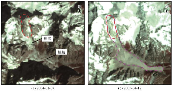
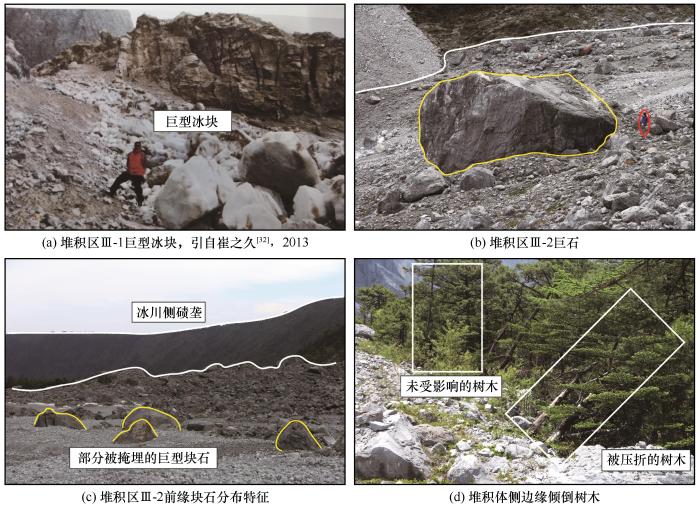
... 滑坡发生后堆积区Ⅲ-1表面分布有大量巨型冰块,粒径约为2~3 m[
图6 (a)].堆积区Ⅲ-2表面分布有巨型块石,粒径大多约为1~2 m,最大直径可达12 m[
图6 (b)],前缘部分块石被掩埋于地表以下[
图6 (c)].岩性为灰岩,岩块棱角分明无分选.
图6 堆积区表面特征 Topography features of the accumulation zone: ice mass in accumulation zone III-1, cited by <xref ref-type="bibr" rid="R32">Cui Zhijiu, 2013</xref><sup>[<xref ref-type="bibr" rid="R32">32</xref>]</sup> (a); boulders in accumulation zone III-2 (b); distribution characteristics of the blocks at the front edge of the accumulation area III-2 (c); trees at the lateral edges of the deposit (d) Fig.6 ![]()
超前气浪作为大型滑坡的重要特征,近年来得到了大量研究.干河坝滑坡海拔3 800 m的西侧崖壁上直径达到20~25 cm的树木全被“剃光头”[32 ] .与树木拦腰折断不同,堆积区Ⅲ-2侧边缘可观察到沿根部倾倒、折断的树木,而距离堆积体稍远位置的树木则保存完好,这些树木分布于随谷形转折后的堆积体两侧(距堆积体前缘约700 m处)[图6 (d)].因此,推测堆积体运动至此处速度变慢,灰岩块石在惯性作用下将两侧树木沿根部推倒,而远侧树木则未受到影响. ...
... [
32 ] (a); boulders in accumulation zone III-2 (b); distribution characteristics of the blocks at the front edge of the accumulation area III-2 (c); trees at the lateral edges of the deposit (d)
Fig.6 ![]()
超前气浪作为大型滑坡的重要特征,近年来得到了大量研究.干河坝滑坡海拔3 800 m的西侧崖壁上直径达到20~25 cm的树木全被“剃光头”[32 ] .与树木拦腰折断不同,堆积区Ⅲ-2侧边缘可观察到沿根部倾倒、折断的树木,而距离堆积体稍远位置的树木则保存完好,这些树木分布于随谷形转折后的堆积体两侧(距堆积体前缘约700 m处)[图6 (d)].因此,推测堆积体运动至此处速度变慢,灰岩块石在惯性作用下将两侧树木沿根部推倒,而远侧树木则未受到影响. ...
... 超前气浪作为大型滑坡的重要特征,近年来得到了大量研究.干河坝滑坡海拔3 800 m的西侧崖壁上直径达到20~25 cm的树木全被“剃光头”[32 ] .与树木拦腰折断不同,堆积区Ⅲ-2侧边缘可观察到沿根部倾倒、折断的树木,而距离堆积体稍远位置的树木则保存完好,这些树木分布于随谷形转折后的堆积体两侧(距堆积体前缘约700 m处)[图6 (d)].因此,推测堆积体运动至此处速度变慢,灰岩块石在惯性作用下将两侧树木沿根部推倒,而远侧树木则未受到影响. ...
... 受冰川融水的侵蚀,堆积区内出露滑坡堆积剖面(图8 ).高速远程滑坡堆积体在竖向上主要呈现出三种相带:堆积体上部的硬壳层(carapace facies)、中部的主体层(body facies)以及下部的基底层(basal facies).硬壳层为堆积体剖面上最靠近顶端大块石富集的相带[11 ] .干河坝冰-岩碎屑流堆积区Ⅲ-2硬壳层主要由大块石组成[图8 (a)].其中,大多数巨石上表面“驮着”小石块(0.5~1 m)和细粒碎屑.该碎屑层主要由1~5 cm的灰岩碎石颗粒组成,呈棱角-次棱角状,崔之久[32 ] 称这种结构为“乘船石”[图8 (b)].该结构与在Blanc冰-岩碎屑流及Lamplugh冰-岩碎屑流堆积体中观察到一种小粒径颗粒“栖息”于巨型块石之上的结构十分相似[18 ,45 ] . ...
6
2013
... 杨情情等[6 ] 在梳理全球冰-岩碎屑流灾害分布时,指出了喜马拉雅-喀喇昆仑山脉灾难性冰-岩碎屑流频发.然而,当前国内关于冰-岩碎屑流的案例研究还很少[29 -30 ] .2004年3月12日,云南省丽江市玉龙雪山南坡发生了剧烈的冰-岩崩塌-碎屑流[20 ] .玉龙雪山地处青藏高原最南端的海洋型冰川区,该区冰-岩碎屑流的发育对我国气候变化下冰川灾害链的研究具有重要意义.此外,玉龙雪山为我国国家级风景名胜区,日游客接待量最高可达5万余人,若冰-岩碎屑流再次发生,很可能会威胁该区游客的生命安全,并迅速改造当地地貌环境[18 ] ,影响该地区的水循环过程,进而影响当地的经济发展[31 ] .崔之久于2007年4月8日对干河坝滑坡进行过初步调查[32 ] ,研究团队于2021年4月27日开展了进一步详细的野外调查工作,判断此事件为冰-岩碎屑流滑坡.本文将通过遥感影像分析、野外调查等手段,研究干河坝冰-岩碎屑流的地貌与堆积特征,反演其运动学过程,在此基础上探讨其超强运动机理,以期进一步加深对冰-岩碎屑流滑坡运动特征的认识,为玉龙雪山乃至青藏高原其他地区类似灾害的预测与防控提供科学依据. ...
... 流通区(Ⅱ区)主要分布在高程3 920~4 337 m之间.其中部发育有一长约40 m,上表面坡度约18°的缓坡平台.该平台将流通区分为三部分,平台向上至滑源区底部坡度约40°,长约260 m.平台向下坡度约26°,长410 m.该平台形成了崩塌块体下滑过程中的缓冲区(图3 ).据前人研究,2006年,该平台处可观察到残留冰体[40 ] ;2007年,该处仍可见饱含岩石碎屑的冰体[32 ] ;2021年时,平台处只可观察到一小部分岩石碎屑.流通区中下部表面光滑,为历史冰川活动形成的磨光面[图3 (a)]. ...
... 滑坡发生后堆积区Ⅲ-1表面分布有大量巨型冰块,粒径约为2~3 m[
图6 (a)].堆积区Ⅲ-2表面分布有巨型块石,粒径大多约为1~2 m,最大直径可达12 m[
图6 (b)],前缘部分块石被掩埋于地表以下[
图6 (c)].岩性为灰岩,岩块棱角分明无分选.
图6 堆积区表面特征 Topography features of the accumulation zone: ice mass in accumulation zone III-1, cited by <xref ref-type="bibr" rid="R32">Cui Zhijiu, 2013</xref><sup>[<xref ref-type="bibr" rid="R32">32</xref>]</sup> (a); boulders in accumulation zone III-2 (b); distribution characteristics of the blocks at the front edge of the accumulation area III-2 (c); trees at the lateral edges of the deposit (d) Fig.6 ![]()
超前气浪作为大型滑坡的重要特征,近年来得到了大量研究.干河坝滑坡海拔3 800 m的西侧崖壁上直径达到20~25 cm的树木全被“剃光头”[32 ] .与树木拦腰折断不同,堆积区Ⅲ-2侧边缘可观察到沿根部倾倒、折断的树木,而距离堆积体稍远位置的树木则保存完好,这些树木分布于随谷形转折后的堆积体两侧(距堆积体前缘约700 m处)[图6 (d)].因此,推测堆积体运动至此处速度变慢,灰岩块石在惯性作用下将两侧树木沿根部推倒,而远侧树木则未受到影响. ...
... [
32 ] (a); boulders in accumulation zone III-2 (b); distribution characteristics of the blocks at the front edge of the accumulation area III-2 (c); trees at the lateral edges of the deposit (d)
Fig.6 ![]()
超前气浪作为大型滑坡的重要特征,近年来得到了大量研究.干河坝滑坡海拔3 800 m的西侧崖壁上直径达到20~25 cm的树木全被“剃光头”[32 ] .与树木拦腰折断不同,堆积区Ⅲ-2侧边缘可观察到沿根部倾倒、折断的树木,而距离堆积体稍远位置的树木则保存完好,这些树木分布于随谷形转折后的堆积体两侧(距堆积体前缘约700 m处)[图6 (d)].因此,推测堆积体运动至此处速度变慢,灰岩块石在惯性作用下将两侧树木沿根部推倒,而远侧树木则未受到影响. ...
... 超前气浪作为大型滑坡的重要特征,近年来得到了大量研究.干河坝滑坡海拔3 800 m的西侧崖壁上直径达到20~25 cm的树木全被“剃光头”[32 ] .与树木拦腰折断不同,堆积区Ⅲ-2侧边缘可观察到沿根部倾倒、折断的树木,而距离堆积体稍远位置的树木则保存完好,这些树木分布于随谷形转折后的堆积体两侧(距堆积体前缘约700 m处)[图6 (d)].因此,推测堆积体运动至此处速度变慢,灰岩块石在惯性作用下将两侧树木沿根部推倒,而远侧树木则未受到影响. ...
... 受冰川融水的侵蚀,堆积区内出露滑坡堆积剖面(图8 ).高速远程滑坡堆积体在竖向上主要呈现出三种相带:堆积体上部的硬壳层(carapace facies)、中部的主体层(body facies)以及下部的基底层(basal facies).硬壳层为堆积体剖面上最靠近顶端大块石富集的相带[11 ] .干河坝冰-岩碎屑流堆积区Ⅲ-2硬壳层主要由大块石组成[图8 (a)].其中,大多数巨石上表面“驮着”小石块(0.5~1 m)和细粒碎屑.该碎屑层主要由1~5 cm的灰岩碎石颗粒组成,呈棱角-次棱角状,崔之久[32 ] 称这种结构为“乘船石”[图8 (b)].该结构与在Blanc冰-岩碎屑流及Lamplugh冰-岩碎屑流堆积体中观察到一种小粒径颗粒“栖息”于巨型块石之上的结构十分相似[18 ,45 ] . ...
OSL dating of the Quaternary glacial sedimentary sequences at Mt. Yulong, China
2
2016
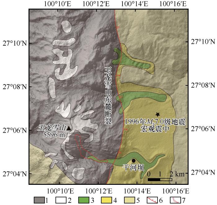
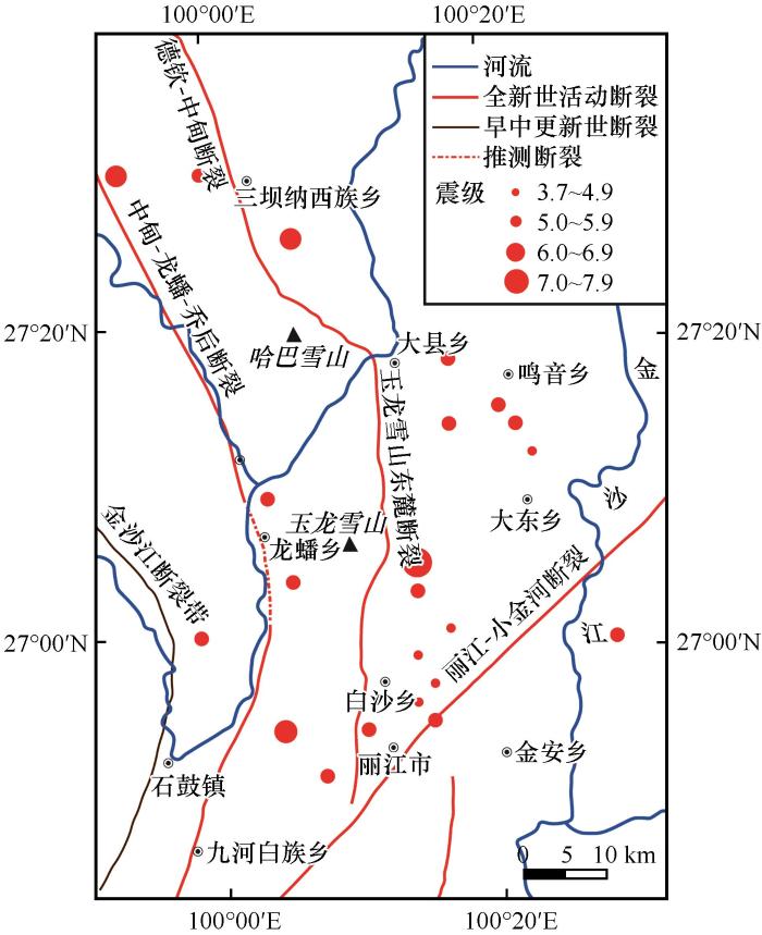
... 玉龙雪山地处青藏高原东南缘,位于云南省丽江市玉龙纳西族自治区,山体走向大致为NNW—SSE,南北蜿蜒约35 km,东西纵横13 km左右[33 ] .干河坝冰-岩碎屑流位于玉龙雪山主峰扇子陡(海拔5 596 m)南侧斜坡地带(27°4′32″~27°5′53″ N,100°10′52″~100°12′38″ E).滑坡区东侧分布有玉龙雪山东麓断裂,为一大型正断层,是丽江地区距今最近一次地震(1996年丽江地震)的主控震构造(图1 )[34 ] . ...
... 滑坡区东侧为玉龙雪山末次冰期(大理冰期)期间所形成的侧碛和终碛垄,高100 m左右[33 ] ,分布于干河坝两侧.干河坝整体呈SE向展布,坝内靠近山体部分为一冰川峡谷,谷形曲折,先向南南东方向延伸约1 500 m,后又向东折延约2 000 m,谷内地形西高东低[38 ] .峡谷两侧陡壁坡度50°~80°,海拔高度约4 000~5 000 m,主要由石炭系和泥盆系的厚层状灰岩组成,呈灰色或深灰色.在寒冻风化作用下,研究区内灰岩风化程度较高,在峡谷两侧发育有大量倒石锥,倒石锥附近灰岩高度破碎.本文所研究冰-岩碎屑流堆积物分布于峡谷内(图1 中红色区域). ...
玉龙雪山冰川沉积序列OSL定年
2
2016
... 玉龙雪山地处青藏高原东南缘,位于云南省丽江市玉龙纳西族自治区,山体走向大致为NNW—SSE,南北蜿蜒约35 km,东西纵横13 km左右[33 ] .干河坝冰-岩碎屑流位于玉龙雪山主峰扇子陡(海拔5 596 m)南侧斜坡地带(27°4′32″~27°5′53″ N,100°10′52″~100°12′38″ E).滑坡区东侧分布有玉龙雪山东麓断裂,为一大型正断层,是丽江地区距今最近一次地震(1996年丽江地震)的主控震构造(图1 )[34 ] . ...
... 滑坡区东侧为玉龙雪山末次冰期(大理冰期)期间所形成的侧碛和终碛垄,高100 m左右[33 ] ,分布于干河坝两侧.干河坝整体呈SE向展布,坝内靠近山体部分为一冰川峡谷,谷形曲折,先向南南东方向延伸约1 500 m,后又向东折延约2 000 m,谷内地形西高东低[38 ] .峡谷两侧陡壁坡度50°~80°,海拔高度约4 000~5 000 m,主要由石炭系和泥盆系的厚层状灰岩组成,呈灰色或深灰色.在寒冻风化作用下,研究区内灰岩风化程度较高,在峡谷两侧发育有大量倒石锥,倒石锥附近灰岩高度破碎.本文所研究冰-岩碎屑流堆积物分布于峡谷内(图1 中红色区域). ...
Seismotectonic emvironment of occurring the Febuary 3, 1996 Lijiang M =7.0 Earthquake, Yunnan Procince
1
2004
... 玉龙雪山地处青藏高原东南缘,位于云南省丽江市玉龙纳西族自治区,山体走向大致为NNW—SSE,南北蜿蜒约35 km,东西纵横13 km左右[33 ] .干河坝冰-岩碎屑流位于玉龙雪山主峰扇子陡(海拔5 596 m)南侧斜坡地带(27°4′32″~27°5′53″ N,100°10′52″~100°12′38″ E).滑坡区东侧分布有玉龙雪山东麓断裂,为一大型正断层,是丽江地区距今最近一次地震(1996年丽江地震)的主控震构造(图1 )[34 ] . ...
1996年2月3日云南丽江7.0级地震发生的构造环境
1
2004
... 玉龙雪山地处青藏高原东南缘,位于云南省丽江市玉龙纳西族自治区,山体走向大致为NNW—SSE,南北蜿蜒约35 km,东西纵横13 km左右[33 ] .干河坝冰-岩碎屑流位于玉龙雪山主峰扇子陡(海拔5 596 m)南侧斜坡地带(27°4′32″~27°5′53″ N,100°10′52″~100°12′38″ E).滑坡区东侧分布有玉龙雪山东麓断裂,为一大型正断层,是丽江地区距今最近一次地震(1996年丽江地震)的主控震构造(图1 )[34 ] . ...
Response of modern monsoon temperate glacier to climate change in Yulong Mountain
2
2013
... 玉龙雪山在纬度上处于亚热带区域,干湿季明显,11月至次年4月为干季,主要受西风环流南支和高原冬季风控制;5—10月为雨季,主要受控于西南与东南季风,降水丰沛[35 ] .自1951至2005年丽江地区气温呈明显上升趋势,其中干季增温显著,高海拔地区增温较低海拔地区显著;虽然湿季降水百分率在85%~99%之间,但年降水量随海拔高度的升高而减少[36 ] .在这样的背景下玉龙雪山的冰川正发生快速变化,具体表现为冰川消融量增加、冰舌位置后退、冰川面积减小、雪线上升等特征[37 ] . ...
... 近年来大量研究表明,气候变暖背景下多年冻土区崩滑灾害频发.冻土退化与冻融作用加剧很可能促进了高寒山区斜坡失稳发育[1 -2 ,53 ] .从1957年至2001年,漾弓江5号冰川面积由0.72 k m 2 k m 2 [35 ,54 ] .干河坝冰-岩碎屑流源区位于该冰川附近多年冻土区,滑坡发生前丽江地区温度呈上升趋势,滑坡发生后岩壁表面有残留冰体存在,这与Haeberli概括的多年冻土退化导致基岩失稳的特征相一致[55 ] . ...
玉龙雪山现代季风温冰川对气候变化的响应
2
2013
... 玉龙雪山在纬度上处于亚热带区域,干湿季明显,11月至次年4月为干季,主要受西风环流南支和高原冬季风控制;5—10月为雨季,主要受控于西南与东南季风,降水丰沛[35 ] .自1951至2005年丽江地区气温呈明显上升趋势,其中干季增温显著,高海拔地区增温较低海拔地区显著;虽然湿季降水百分率在85%~99%之间,但年降水量随海拔高度的升高而减少[36 ] .在这样的背景下玉龙雪山的冰川正发生快速变化,具体表现为冰川消融量增加、冰舌位置后退、冰川面积减小、雪线上升等特征[37 ] . ...
... 近年来大量研究表明,气候变暖背景下多年冻土区崩滑灾害频发.冻土退化与冻融作用加剧很可能促进了高寒山区斜坡失稳发育[1 -2 ,53 ] .从1957年至2001年,漾弓江5号冰川面积由0.72 k m 2 k m 2 [35 ,54 ] .干河坝冰-岩碎屑流源区位于该冰川附近多年冻土区,滑坡发生前丽江地区温度呈上升趋势,滑坡发生后岩壁表面有残留冰体存在,这与Haeberli概括的多年冻土退化导致基岩失稳的特征相一致[55 ] . ...
The features of climate variation and glacier response in Mt. Yulong, southeastern Tibetan Plateau
1
2013
... 玉龙雪山在纬度上处于亚热带区域,干湿季明显,11月至次年4月为干季,主要受西风环流南支和高原冬季风控制;5—10月为雨季,主要受控于西南与东南季风,降水丰沛[35 ] .自1951至2005年丽江地区气温呈明显上升趋势,其中干季增温显著,高海拔地区增温较低海拔地区显著;虽然湿季降水百分率在85%~99%之间,但年降水量随海拔高度的升高而减少[36 ] .在这样的背景下玉龙雪山的冰川正发生快速变化,具体表现为冰川消融量增加、冰舌位置后退、冰川面积减小、雪线上升等特征[37 ] . ...
青藏高原东南缘丽江玉龙雪山气候变化特征及其对冰川变化的影响
1
2013
... 玉龙雪山在纬度上处于亚热带区域,干湿季明显,11月至次年4月为干季,主要受西风环流南支和高原冬季风控制;5—10月为雨季,主要受控于西南与东南季风,降水丰沛[35 ] .自1951至2005年丽江地区气温呈明显上升趋势,其中干季增温显著,高海拔地区增温较低海拔地区显著;虽然湿季降水百分率在85%~99%之间,但年降水量随海拔高度的升高而减少[36 ] .在这样的背景下玉龙雪山的冰川正发生快速变化,具体表现为冰川消融量增加、冰舌位置后退、冰川面积减小、雪线上升等特征[37 ] . ...
Climatic warming is the major reason for glacier retreat on Mt. Yulong, China
1
2004
... 玉龙雪山在纬度上处于亚热带区域,干湿季明显,11月至次年4月为干季,主要受西风环流南支和高原冬季风控制;5—10月为雨季,主要受控于西南与东南季风,降水丰沛[35 ] .自1951至2005年丽江地区气温呈明显上升趋势,其中干季增温显著,高海拔地区增温较低海拔地区显著;虽然湿季降水百分率在85%~99%之间,但年降水量随海拔高度的升高而减少[36 ] .在这样的背景下玉龙雪山的冰川正发生快速变化,具体表现为冰川消融量增加、冰舌位置后退、冰川面积减小、雪线上升等特征[37 ] . ...
气候变暖是玉龙雪山冰川退缩的主要原因
1
2004
... 玉龙雪山在纬度上处于亚热带区域,干湿季明显,11月至次年4月为干季,主要受西风环流南支和高原冬季风控制;5—10月为雨季,主要受控于西南与东南季风,降水丰沛[35 ] .自1951至2005年丽江地区气温呈明显上升趋势,其中干季增温显著,高海拔地区增温较低海拔地区显著;虽然湿季降水百分率在85%~99%之间,但年降水量随海拔高度的升高而减少[36 ] .在这样的背景下玉龙雪山的冰川正发生快速变化,具体表现为冰川消融量增加、冰舌位置后退、冰川面积减小、雪线上升等特征[37 ] . ...
The Quaternary glaciation in Yu-long Mountains
1
1996
... 滑坡区东侧为玉龙雪山末次冰期(大理冰期)期间所形成的侧碛和终碛垄,高100 m左右[33 ] ,分布于干河坝两侧.干河坝整体呈SE向展布,坝内靠近山体部分为一冰川峡谷,谷形曲折,先向南南东方向延伸约1 500 m,后又向东折延约2 000 m,谷内地形西高东低[38 ] .峡谷两侧陡壁坡度50°~80°,海拔高度约4 000~5 000 m,主要由石炭系和泥盆系的厚层状灰岩组成,呈灰色或深灰色.在寒冻风化作用下,研究区内灰岩风化程度较高,在峡谷两侧发育有大量倒石锥,倒石锥附近灰岩高度破碎.本文所研究冰-岩碎屑流堆积物分布于峡谷内(图1 中红色区域). ...
滇西北玉龙山第四纪冰川作用的探讨
1
1996
... 滑坡区东侧为玉龙雪山末次冰期(大理冰期)期间所形成的侧碛和终碛垄,高100 m左右[33 ] ,分布于干河坝两侧.干河坝整体呈SE向展布,坝内靠近山体部分为一冰川峡谷,谷形曲折,先向南南东方向延伸约1 500 m,后又向东折延约2 000 m,谷内地形西高东低[38 ] .峡谷两侧陡壁坡度50°~80°,海拔高度约4 000~5 000 m,主要由石炭系和泥盆系的厚层状灰岩组成,呈灰色或深灰色.在寒冻风化作用下,研究区内灰岩风化程度较高,在峡谷两侧发育有大量倒石锥,倒石锥附近灰岩高度破碎.本文所研究冰-岩碎屑流堆积物分布于峡谷内(图1 中红色区域). ...
Exploration of the late quaternary normal faulting and its kinetic mechanism in the Haba-Yulong Xueshan east rift, Northwest Yunnan
2
2008
... 图例说明:1. 泥盆纪-早二叠世灰岩; 2. 现代冰川; 3. 末次冰期以来的冰碛-冰水沉积物; 4. 末次冰期前冰碛-冰水沉积物; 5. 晚二叠世-三叠纪火山-沉积地层; 6. 活动正断层; 7. 干河坝冰-岩碎屑流.改自吴中海等[39 ] ,2008 ...
... Legend: 1. Devonian-Early Permian strata; 2. modern glaciers;3. glacial deposits of last ice age; 4. glacial deposits of pre-last ice age; 5. Late Permian-Triassic strata; 6. faults; 7. Ganheba rock-ice avalanche. Adapted from Wu et al[39 ] , 2008 ...
滇西北哈巴-玉龙雪山东麓断裂的晚第四纪正断层作用及其动力学机制探讨
2
2008
... 图例说明:1. 泥盆纪-早二叠世灰岩; 2. 现代冰川; 3. 末次冰期以来的冰碛-冰水沉积物; 4. 末次冰期前冰碛-冰水沉积物; 5. 晚二叠世-三叠纪火山-沉积地层; 6. 活动正断层; 7. 干河坝冰-岩碎屑流.改自吴中海等[39 ] ,2008 ...
... Legend: 1. Devonian-Early Permian strata; 2. modern glaciers;3. glacial deposits of last ice age; 4. glacial deposits of pre-last ice age; 5. Late Permian-Triassic strata; 6. faults; 7. Ganheba rock-ice avalanche. Adapted from Wu et al[39 ] , 2008 ...
The analysis of icefall at Mt. Yulong
3
2007
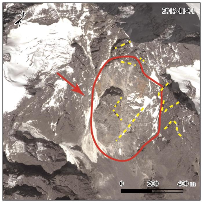
... 滑坡发生后在源区后部形成了一处高差约1 013 m的基岩后壁,壁面产状为156°∠48°(图4 ).受地形限制,本研究并未对源区结构面产状进行实测,但玉龙雪山主体部分由几个强烈的直立褶皱组成,滑坡源区附近发育有一组近于直立的剪节理[40 -41 ] .基于2005年卫星影像中源区基岩结构面发育情况(图4 黄色虚线)与峡谷南北两侧灰岩结构面产状(111°∠75°;300°∠89°),推测斜坡上部为陡倾和顺向结构面组合. ...
... 流通区(Ⅱ区)主要分布在高程3 920~4 337 m之间.其中部发育有一长约40 m,上表面坡度约18°的缓坡平台.该平台将流通区分为三部分,平台向上至滑源区底部坡度约40°,长约260 m.平台向下坡度约26°,长410 m.该平台形成了崩塌块体下滑过程中的缓冲区(图3 ).据前人研究,2006年,该平台处可观察到残留冰体[40 ] ;2007年,该处仍可见饱含岩石碎屑的冰体[32 ] ;2021年时,平台处只可观察到一小部分岩石碎屑.流通区中下部表面光滑,为历史冰川活动形成的磨光面[图3 (a)]. ...
... 冻融作用导致的斜坡失稳系含冰节理发育所致.每年春夏至秋初,由于气温升高,冻土区冰体消融,冰融水渗入基岩节理裂隙中导致裂隙发生扩张[55 -56 ] ,岩石强度降低.而且冰川融水对玉龙雪山地区灰岩的溶蚀作用进一步加剧了岩石损伤[40 ] .因此,在长年累月反复作用下,源区基岩的节理裂缝不断扩大.直至2003年春季,基岩裂隙内冰体强烈消融既降低了冰体与岩体之间的摩擦力[57 ] ,也因此产生静水压力降低了基岩的有效应力[55 ] ,最终导致源区基岩沿节理裂隙面产生滑动,形成干河坝冰-岩碎屑流. ...
玉龙雪山冰川崩塌成因分析
3
2007
... 滑坡发生后在源区后部形成了一处高差约1 013 m的基岩后壁,壁面产状为156°∠48°(图4 ).受地形限制,本研究并未对源区结构面产状进行实测,但玉龙雪山主体部分由几个强烈的直立褶皱组成,滑坡源区附近发育有一组近于直立的剪节理[40 -41 ] .基于2005年卫星影像中源区基岩结构面发育情况(图4 黄色虚线)与峡谷南北两侧灰岩结构面产状(111°∠75°;300°∠89°),推测斜坡上部为陡倾和顺向结构面组合. ...
... 流通区(Ⅱ区)主要分布在高程3 920~4 337 m之间.其中部发育有一长约40 m,上表面坡度约18°的缓坡平台.该平台将流通区分为三部分,平台向上至滑源区底部坡度约40°,长约260 m.平台向下坡度约26°,长410 m.该平台形成了崩塌块体下滑过程中的缓冲区(图3 ).据前人研究,2006年,该平台处可观察到残留冰体[40 ] ;2007年,该处仍可见饱含岩石碎屑的冰体[32 ] ;2021年时,平台处只可观察到一小部分岩石碎屑.流通区中下部表面光滑,为历史冰川活动形成的磨光面[图3 (a)]. ...
... 冻融作用导致的斜坡失稳系含冰节理发育所致.每年春夏至秋初,由于气温升高,冻土区冰体消融,冰融水渗入基岩节理裂隙中导致裂隙发生扩张[55 -56 ] ,岩石强度降低.而且冰川融水对玉龙雪山地区灰岩的溶蚀作用进一步加剧了岩石损伤[40 ] .因此,在长年累月反复作用下,源区基岩的节理裂缝不断扩大.直至2003年春季,基岩裂隙内冰体强烈消融既降低了冰体与岩体之间的摩擦力[57 ] ,也因此产生静水压力降低了基岩的有效应力[55 ] ,最终导致源区基岩沿节理裂隙面产生滑动,形成干河坝冰-岩碎屑流. ...
Neotectonic movement in the Yulong Mountains
1
1991
... 滑坡发生后在源区后部形成了一处高差约1 013 m的基岩后壁,壁面产状为156°∠48°(图4 ).受地形限制,本研究并未对源区结构面产状进行实测,但玉龙雪山主体部分由几个强烈的直立褶皱组成,滑坡源区附近发育有一组近于直立的剪节理[40 -41 ] .基于2005年卫星影像中源区基岩结构面发育情况(图4 黄色虚线)与峡谷南北两侧灰岩结构面产状(111°∠75°;300°∠89°),推测斜坡上部为陡倾和顺向结构面组合. ...
滇西北玉龙山新构造运动研究
1
1991
... 滑坡发生后在源区后部形成了一处高差约1 013 m的基岩后壁,壁面产状为156°∠48°(图4 ).受地形限制,本研究并未对源区结构面产状进行实测,但玉龙雪山主体部分由几个强烈的直立褶皱组成,滑坡源区附近发育有一组近于直立的剪节理[40 -41 ] .基于2005年卫星影像中源区基岩结构面发育情况(图4 黄色虚线)与峡谷南北两侧灰岩结构面产状(111°∠75°;300°∠89°),推测斜坡上部为陡倾和顺向结构面组合. ...
The frontal ice avalanche of Frebouge Glacier (Mont Blanc Massif, Valley of Aosta, NW Italy) on 18 September 2002
1
2002
... 堆积区(Ⅲ区)长约2 860 m,海拔高度位于3 379 m至3 712 m之间,可分为Ⅲ-1区和Ⅲ-2区[图3 (a)].二者堆积体厚度具有明显差异,这与Blanc冰-岩碎屑流和Frebouge冰-岩碎屑流表现出的局部堆积体富集的特征相似[18 ,42 ] . ...
The sedimentology and geomorphology of rock avalanche deposits on glaciers
1
2011
... 堆积区Ⅲ-1位于坡脚,总面积约0.092 k m 2 图5 (a)].该处冰体现已消融,其余堆积体在滑坡发生后十余年间不断扩张变形[图5 (b)],形成数条明显的弧形横向脊[图3 (a),图5 (c)],这种缓慢扩张形式和Sherman冰-岩碎屑流滑坡相似[43 ] . ...
Entrainment of debris in rock avalanches: an analysis of a long run-out mechanism
1
2004
... 根据以上调查,最终计算各区几何参数如表2 所示.滑坡最大高差约1 971 m.最长水平距离约4 860 m,H /L 约为0.4.滑源区崩塌块体体积约为9.1×10⁶ m 3 6 m 3 [44 ] 所提出的岩体破碎会使堆积体体积增加25%的结果基本一致. ...
The 2016 Lamplugh rock avalanche, Alaska: deposit structures and emplacement dynamics
1
2019
... 受冰川融水的侵蚀,堆积区内出露滑坡堆积剖面(图8 ).高速远程滑坡堆积体在竖向上主要呈现出三种相带:堆积体上部的硬壳层(carapace facies)、中部的主体层(body facies)以及下部的基底层(basal facies).硬壳层为堆积体剖面上最靠近顶端大块石富集的相带[11 ] .干河坝冰-岩碎屑流堆积区Ⅲ-2硬壳层主要由大块石组成[图8 (a)].其中,大多数巨石上表面“驮着”小石块(0.5~1 m)和细粒碎屑.该碎屑层主要由1~5 cm的灰岩碎石颗粒组成,呈棱角-次棱角状,崔之久[32 ] 称这种结构为“乘船石”[图8 (b)].该结构与在Blanc冰-岩碎屑流及Lamplugh冰-岩碎屑流堆积体中观察到一种小粒径颗粒“栖息”于巨型块石之上的结构十分相似[18 ,45 ] . ...
Susceptibility assessment of post-earthquake landslide and timeliness research
1
2022
... 地震作用会导致岩体内部裂缝增加,岩体内裂缝可能会促进冻融循环等物理风化过程,尤其陡坡因地形放大效应会受到更大的影响[46 -47 ] .因此,受到地震影响的边坡可能长期处于临界失稳状态,在地震后数月或是数年才会发生破坏,如1987年Parraguirre滑坡与2002年Kolka-Karmadon滑坡[48 -49 ] .据统计,20世纪以来,云南境内记录到5级以上的地震377次,其中7级以上地震13次,震源深度大都在9~24 km[50 ] .其中距源区最近的一次地震为1996年丽江地震,震级为7级,震源深度为10 km,宏观震中位置距该滑坡区约7 km,共诱发了至少420处中小型崩塌和30处大中型滑坡[51 ] .干河坝冰-岩碎屑流源区位于玉龙雪山主峰山脊处,坡度较陡(约48°).因此,虽然地震活动数据表明干河坝滑坡的发生与地震并无直接关系,但玉龙雪山地区构造运动活跃(图9 ),历史地震很可能导致滑源区岩层沿节理面发生结构性破坏,促使边坡处于临界失稳状态. ...
震后滑坡易发性评价及其时效性研究
1
2022
... 地震作用会导致岩体内部裂缝增加,岩体内裂缝可能会促进冻融循环等物理风化过程,尤其陡坡因地形放大效应会受到更大的影响[46 -47 ] .因此,受到地震影响的边坡可能长期处于临界失稳状态,在地震后数月或是数年才会发生破坏,如1987年Parraguirre滑坡与2002年Kolka-Karmadon滑坡[48 -49 ] .据统计,20世纪以来,云南境内记录到5级以上的地震377次,其中7级以上地震13次,震源深度大都在9~24 km[50 ] .其中距源区最近的一次地震为1996年丽江地震,震级为7级,震源深度为10 km,宏观震中位置距该滑坡区约7 km,共诱发了至少420处中小型崩塌和30处大中型滑坡[51 ] .干河坝冰-岩碎屑流源区位于玉龙雪山主峰山脊处,坡度较陡(约48°).因此,虽然地震活动数据表明干河坝滑坡的发生与地震并无直接关系,但玉龙雪山地区构造运动活跃(图9 ),历史地震很可能导致滑源区岩层沿节理面发生结构性破坏,促使边坡处于临界失稳状态. ...
Earthquake-induced chains of geologic hazards: patterns, mechanisms, and impacts
1
2019
... 地震作用会导致岩体内部裂缝增加,岩体内裂缝可能会促进冻融循环等物理风化过程,尤其陡坡因地形放大效应会受到更大的影响[46 -47 ] .因此,受到地震影响的边坡可能长期处于临界失稳状态,在地震后数月或是数年才会发生破坏,如1987年Parraguirre滑坡与2002年Kolka-Karmadon滑坡[48 -49 ] .据统计,20世纪以来,云南境内记录到5级以上的地震377次,其中7级以上地震13次,震源深度大都在9~24 km[50 ] .其中距源区最近的一次地震为1996年丽江地震,震级为7级,震源深度为10 km,宏观震中位置距该滑坡区约7 km,共诱发了至少420处中小型崩塌和30处大中型滑坡[51 ] .干河坝冰-岩碎屑流源区位于玉龙雪山主峰山脊处,坡度较陡(约48°).因此,虽然地震活动数据表明干河坝滑坡的发生与地震并无直接关系,但玉龙雪山地区构造运动活跃(图9 ),历史地震很可能导致滑源区岩层沿节理面发生结构性破坏,促使边坡处于临界失稳状态. ...
Catastrophic glacial multi-phase mass movements: a special type of glacial hazard
1
2008
... 地震作用会导致岩体内部裂缝增加,岩体内裂缝可能会促进冻融循环等物理风化过程,尤其陡坡因地形放大效应会受到更大的影响[46 -47 ] .因此,受到地震影响的边坡可能长期处于临界失稳状态,在地震后数月或是数年才会发生破坏,如1987年Parraguirre滑坡与2002年Kolka-Karmadon滑坡[48 -49 ] .据统计,20世纪以来,云南境内记录到5级以上的地震377次,其中7级以上地震13次,震源深度大都在9~24 km[50 ] .其中距源区最近的一次地震为1996年丽江地震,震级为7级,震源深度为10 km,宏观震中位置距该滑坡区约7 km,共诱发了至少420处中小型崩塌和30处大中型滑坡[51 ] .干河坝冰-岩碎屑流源区位于玉龙雪山主峰山脊处,坡度较陡(约48°).因此,虽然地震活动数据表明干河坝滑坡的发生与地震并无直接关系,但玉龙雪山地区构造运动活跃(图9 ),历史地震很可能导致滑源区岩层沿节理面发生结构性破坏,促使边坡处于临界失稳状态. ...
The Hattian Bala rock avalanche and associated landslides triggered by the Kashmir Earthquake of 8 October 2005
1
2007
... 地震作用会导致岩体内部裂缝增加,岩体内裂缝可能会促进冻融循环等物理风化过程,尤其陡坡因地形放大效应会受到更大的影响[46 -47 ] .因此,受到地震影响的边坡可能长期处于临界失稳状态,在地震后数月或是数年才会发生破坏,如1987年Parraguirre滑坡与2002年Kolka-Karmadon滑坡[48 -49 ] .据统计,20世纪以来,云南境内记录到5级以上的地震377次,其中7级以上地震13次,震源深度大都在9~24 km[50 ] .其中距源区最近的一次地震为1996年丽江地震,震级为7级,震源深度为10 km,宏观震中位置距该滑坡区约7 km,共诱发了至少420处中小型崩塌和30处大中型滑坡[51 ] .干河坝冰-岩碎屑流源区位于玉龙雪山主峰山脊处,坡度较陡(约48°).因此,虽然地震活动数据表明干河坝滑坡的发生与地震并无直接关系,但玉龙雪山地区构造运动活跃(图9 ),历史地震很可能导致滑源区岩层沿节理面发生结构性破坏,促使边坡处于临界失稳状态. ...
Study on seismicity in Yunnan in the 20th century
1
2000
... 地震作用会导致岩体内部裂缝增加,岩体内裂缝可能会促进冻融循环等物理风化过程,尤其陡坡因地形放大效应会受到更大的影响[46 -47 ] .因此,受到地震影响的边坡可能长期处于临界失稳状态,在地震后数月或是数年才会发生破坏,如1987年Parraguirre滑坡与2002年Kolka-Karmadon滑坡[48 -49 ] .据统计,20世纪以来,云南境内记录到5级以上的地震377次,其中7级以上地震13次,震源深度大都在9~24 km[50 ] .其中距源区最近的一次地震为1996年丽江地震,震级为7级,震源深度为10 km,宏观震中位置距该滑坡区约7 km,共诱发了至少420处中小型崩塌和30处大中型滑坡[51 ] .干河坝冰-岩碎屑流源区位于玉龙雪山主峰山脊处,坡度较陡(约48°).因此,虽然地震活动数据表明干河坝滑坡的发生与地震并无直接关系,但玉龙雪山地区构造运动活跃(图9 ),历史地震很可能导致滑源区岩层沿节理面发生结构性破坏,促使边坡处于临界失稳状态. ...
20世纪云南地震活动研究
1
2000
... 地震作用会导致岩体内部裂缝增加,岩体内裂缝可能会促进冻融循环等物理风化过程,尤其陡坡因地形放大效应会受到更大的影响[46 -47 ] .因此,受到地震影响的边坡可能长期处于临界失稳状态,在地震后数月或是数年才会发生破坏,如1987年Parraguirre滑坡与2002年Kolka-Karmadon滑坡[48 -49 ] .据统计,20世纪以来,云南境内记录到5级以上的地震377次,其中7级以上地震13次,震源深度大都在9~24 km[50 ] .其中距源区最近的一次地震为1996年丽江地震,震级为7级,震源深度为10 km,宏观震中位置距该滑坡区约7 km,共诱发了至少420处中小型崩塌和30处大中型滑坡[51 ] .干河坝冰-岩碎屑流源区位于玉龙雪山主峰山脊处,坡度较陡(约48°).因此,虽然地震活动数据表明干河坝滑坡的发生与地震并无直接关系,但玉龙雪山地区构造运动活跃(图9 ),历史地震很可能导致滑源区岩层沿节理面发生结构性破坏,促使边坡处于临界失稳状态. ...
Lijiang earthquake and the incuced rockfalls and slumps in Yunnan
1
1997
... 地震作用会导致岩体内部裂缝增加,岩体内裂缝可能会促进冻融循环等物理风化过程,尤其陡坡因地形放大效应会受到更大的影响[46 -47 ] .因此,受到地震影响的边坡可能长期处于临界失稳状态,在地震后数月或是数年才会发生破坏,如1987年Parraguirre滑坡与2002年Kolka-Karmadon滑坡[48 -49 ] .据统计,20世纪以来,云南境内记录到5级以上的地震377次,其中7级以上地震13次,震源深度大都在9~24 km[50 ] .其中距源区最近的一次地震为1996年丽江地震,震级为7级,震源深度为10 km,宏观震中位置距该滑坡区约7 km,共诱发了至少420处中小型崩塌和30处大中型滑坡[51 ] .干河坝冰-岩碎屑流源区位于玉龙雪山主峰山脊处,坡度较陡(约48°).因此,虽然地震活动数据表明干河坝滑坡的发生与地震并无直接关系,但玉龙雪山地区构造运动活跃(图9 ),历史地震很可能导致滑源区岩层沿节理面发生结构性破坏,促使边坡处于临界失稳状态. ...
云南省丽江大地震及其诱发的崩塌滑坡灾害特征
1
1997
... 地震作用会导致岩体内部裂缝增加,岩体内裂缝可能会促进冻融循环等物理风化过程,尤其陡坡因地形放大效应会受到更大的影响[46 -47 ] .因此,受到地震影响的边坡可能长期处于临界失稳状态,在地震后数月或是数年才会发生破坏,如1987年Parraguirre滑坡与2002年Kolka-Karmadon滑坡[48 -49 ] .据统计,20世纪以来,云南境内记录到5级以上的地震377次,其中7级以上地震13次,震源深度大都在9~24 km[50 ] .其中距源区最近的一次地震为1996年丽江地震,震级为7级,震源深度为10 km,宏观震中位置距该滑坡区约7 km,共诱发了至少420处中小型崩塌和30处大中型滑坡[51 ] .干河坝冰-岩碎屑流源区位于玉龙雪山主峰山脊处,坡度较陡(约48°).因此,虽然地震活动数据表明干河坝滑坡的发生与地震并无直接关系,但玉龙雪山地区构造运动活跃(图9 ),历史地震很可能导致滑源区岩层沿节理面发生结构性破坏,促使边坡处于临界失稳状态. ...
Kinematic property of the eastern piedmont fault of Yulong Mountains and its implication for geomorphology in Yunnan, southwest of China
2
2017
... 地震作用会导致岩体内部裂缝增加,岩体内裂缝可能会促进冻融循环等物理风化过程,尤其陡坡因地形放大效应会受到更大的影响
[46 -47 ] .因此,受到地震影响的边坡可能长期处于临界失稳状态,在地震后数月或是数年才会发生破坏,如1987年Parraguirre滑坡与2002年Kolka-Karmadon滑坡
[48 -49 ] .据统计,20世纪以来,云南境内记录到5级以上的地震377次,其中7级以上地震13次,震源深度大都在9~24 km
[50 ] .其中距源区最近的一次地震为1996年丽江地震,震级为7级,震源深度为10 km,宏观震中位置距该滑坡区约7 km,共诱发了至少420处中小型崩塌和30处大中型滑坡
[51 ] .干河坝冰-岩碎屑流源区位于玉龙雪山主峰山脊处,坡度较陡(约48°).因此,虽然地震活动数据表明干河坝滑坡的发生与地震并无直接关系,但玉龙雪山地区构造运动活跃(
图9 ),历史地震很可能导致滑源区岩层沿节理面发生结构性破坏,促使边坡处于临界失稳状态.
图9 玉龙雪山地区历史地震分布情况,引自尹功明等<sup>[<xref ref-type="bibr" rid="R52">52</xref>]</sup>,2017 Historical earthquake distribution at Yulong Snow Mountain, adapted from Yin Gongming et al<sup>[<xref ref-type="bibr" rid="R52">52</xref>]</sup>, 2017 Fig.9 ![]()
5.2 冻融作用 近年来大量研究表明,气候变暖背景下多年冻土区崩滑灾害频发.冻土退化与冻融作用加剧很可能促进了高寒山区斜坡失稳发育[1 -2 ,53 ] .从1957年至2001年,漾弓江5号冰川面积由0.72 k m 2 k m 2 [35 ,54 ] .干河坝冰-岩碎屑流源区位于该冰川附近多年冻土区,滑坡发生前丽江地区温度呈上升趋势,滑坡发生后岩壁表面有残留冰体存在,这与Haeberli概括的多年冻土退化导致基岩失稳的特征相一致[55 ] . ...
... [
52 ], 2017
Fig.9 ![]()
5.2 冻融作用 近年来大量研究表明,气候变暖背景下多年冻土区崩滑灾害频发.冻土退化与冻融作用加剧很可能促进了高寒山区斜坡失稳发育[1 -2 ,53 ] .从1957年至2001年,漾弓江5号冰川面积由0.72 k m 2 k m 2 [35 ,54 ] .干河坝冰-岩碎屑流源区位于该冰川附近多年冻土区,滑坡发生前丽江地区温度呈上升趋势,滑坡发生后岩壁表面有残留冰体存在,这与Haeberli概括的多年冻土退化导致基岩失稳的特征相一致[55 ] . ...
云南玉龙雪山东麓断层的运动性质及其地貌意义
2
2017
... 地震作用会导致岩体内部裂缝增加,岩体内裂缝可能会促进冻融循环等物理风化过程,尤其陡坡因地形放大效应会受到更大的影响
[46 -47 ] .因此,受到地震影响的边坡可能长期处于临界失稳状态,在地震后数月或是数年才会发生破坏,如1987年Parraguirre滑坡与2002年Kolka-Karmadon滑坡
[48 -49 ] .据统计,20世纪以来,云南境内记录到5级以上的地震377次,其中7级以上地震13次,震源深度大都在9~24 km
[50 ] .其中距源区最近的一次地震为1996年丽江地震,震级为7级,震源深度为10 km,宏观震中位置距该滑坡区约7 km,共诱发了至少420处中小型崩塌和30处大中型滑坡
[51 ] .干河坝冰-岩碎屑流源区位于玉龙雪山主峰山脊处,坡度较陡(约48°).因此,虽然地震活动数据表明干河坝滑坡的发生与地震并无直接关系,但玉龙雪山地区构造运动活跃(
图9 ),历史地震很可能导致滑源区岩层沿节理面发生结构性破坏,促使边坡处于临界失稳状态.
图9 玉龙雪山地区历史地震分布情况,引自尹功明等<sup>[<xref ref-type="bibr" rid="R52">52</xref>]</sup>,2017 Historical earthquake distribution at Yulong Snow Mountain, adapted from Yin Gongming et al<sup>[<xref ref-type="bibr" rid="R52">52</xref>]</sup>, 2017 Fig.9 ![]()
5.2 冻融作用 近年来大量研究表明,气候变暖背景下多年冻土区崩滑灾害频发.冻土退化与冻融作用加剧很可能促进了高寒山区斜坡失稳发育[1 -2 ,53 ] .从1957年至2001年,漾弓江5号冰川面积由0.72 k m 2 k m 2 [35 ,54 ] .干河坝冰-岩碎屑流源区位于该冰川附近多年冻土区,滑坡发生前丽江地区温度呈上升趋势,滑坡发生后岩壁表面有残留冰体存在,这与Haeberli概括的多年冻土退化导致基岩失稳的特征相一致[55 ] . ...
... [
52 ], 2017
Fig.9 ![]()
5.2 冻融作用 近年来大量研究表明,气候变暖背景下多年冻土区崩滑灾害频发.冻土退化与冻融作用加剧很可能促进了高寒山区斜坡失稳发育[1 -2 ,53 ] .从1957年至2001年,漾弓江5号冰川面积由0.72 k m 2 k m 2 [35 ,54 ] .干河坝冰-岩碎屑流源区位于该冰川附近多年冻土区,滑坡发生前丽江地区温度呈上升趋势,滑坡发生后岩壁表面有残留冰体存在,这与Haeberli概括的多年冻土退化导致基岩失稳的特征相一致[55 ] . ...
Geology, glacier retreat and permafrost degradation as controlling factors of slope instabilities in a high-mountain rock wall: the Monte Rosa east face
1
2006
... 近年来大量研究表明,气候变暖背景下多年冻土区崩滑灾害频发.冻土退化与冻融作用加剧很可能促进了高寒山区斜坡失稳发育[1 -2 ,53 ] .从1957年至2001年,漾弓江5号冰川面积由0.72 k m 2 k m 2 [35 ,54 ] .干河坝冰-岩碎屑流源区位于该冰川附近多年冻土区,滑坡发生前丽江地区温度呈上升趋势,滑坡发生后岩壁表面有残留冰体存在,这与Haeberli概括的多年冻土退化导致基岩失稳的特征相一致[55 ] . ...
The research of glacier change in the Yulong Snow Mountains based on RS and observation data
1
2011
... 近年来大量研究表明,气候变暖背景下多年冻土区崩滑灾害频发.冻土退化与冻融作用加剧很可能促进了高寒山区斜坡失稳发育[1 -2 ,53 ] .从1957年至2001年,漾弓江5号冰川面积由0.72 k m 2 k m 2 [35 ,54 ] .干河坝冰-岩碎屑流源区位于该冰川附近多年冻土区,滑坡发生前丽江地区温度呈上升趋势,滑坡发生后岩壁表面有残留冰体存在,这与Haeberli概括的多年冻土退化导致基岩失稳的特征相一致[55 ] . ...
基于遥感与实测的玉龙雪山冰川变化
1
2011
... 近年来大量研究表明,气候变暖背景下多年冻土区崩滑灾害频发.冻土退化与冻融作用加剧很可能促进了高寒山区斜坡失稳发育[1 -2 ,53 ] .从1957年至2001年,漾弓江5号冰川面积由0.72 k m 2 k m 2 [35 ,54 ] .干河坝冰-岩碎屑流源区位于该冰川附近多年冻土区,滑坡发生前丽江地区温度呈上升趋势,滑坡发生后岩壁表面有残留冰体存在,这与Haeberli概括的多年冻土退化导致基岩失稳的特征相一致[55 ] . ...
Permafrost in steep bedrock slopes and its temperature-related destabilization following climate change
3
2007
... 近年来大量研究表明,气候变暖背景下多年冻土区崩滑灾害频发.冻土退化与冻融作用加剧很可能促进了高寒山区斜坡失稳发育[1 -2 ,53 ] .从1957年至2001年,漾弓江5号冰川面积由0.72 k m 2 k m 2 [35 ,54 ] .干河坝冰-岩碎屑流源区位于该冰川附近多年冻土区,滑坡发生前丽江地区温度呈上升趋势,滑坡发生后岩壁表面有残留冰体存在,这与Haeberli概括的多年冻土退化导致基岩失稳的特征相一致[55 ] . ...
... 冻融作用导致的斜坡失稳系含冰节理发育所致.每年春夏至秋初,由于气温升高,冻土区冰体消融,冰融水渗入基岩节理裂隙中导致裂隙发生扩张[55 -56 ] ,岩石强度降低.而且冰川融水对玉龙雪山地区灰岩的溶蚀作用进一步加剧了岩石损伤[40 ] .因此,在长年累月反复作用下,源区基岩的节理裂缝不断扩大.直至2003年春季,基岩裂隙内冰体强烈消融既降低了冰体与岩体之间的摩擦力[57 ] ,也因此产生静水压力降低了基岩的有效应力[55 ] ,最终导致源区基岩沿节理裂隙面产生滑动,形成干河坝冰-岩碎屑流. ...
... [55 ],最终导致源区基岩沿节理裂隙面产生滑动,形成干河坝冰-岩碎屑流. ...
Kinematics of steep bedrock permafrost
1
2012
... 冻融作用导致的斜坡失稳系含冰节理发育所致.每年春夏至秋初,由于气温升高,冻土区冰体消融,冰融水渗入基岩节理裂隙中导致裂隙发生扩张[55 -56 ] ,岩石强度降低.而且冰川融水对玉龙雪山地区灰岩的溶蚀作用进一步加剧了岩石损伤[40 ] .因此,在长年累月反复作用下,源区基岩的节理裂缝不断扩大.直至2003年春季,基岩裂隙内冰体强烈消融既降低了冰体与岩体之间的摩擦力[57 ] ,也因此产生静水压力降低了基岩的有效应力[55 ] ,最终导致源区基岩沿节理裂隙面产生滑动,形成干河坝冰-岩碎屑流. ...
Avalanching glacier instabilities: review on processes and early warning perspectives
1
2015
... 冻融作用导致的斜坡失稳系含冰节理发育所致.每年春夏至秋初,由于气温升高,冻土区冰体消融,冰融水渗入基岩节理裂隙中导致裂隙发生扩张[55 -56 ] ,岩石强度降低.而且冰川融水对玉龙雪山地区灰岩的溶蚀作用进一步加剧了岩石损伤[40 ] .因此,在长年累月反复作用下,源区基岩的节理裂缝不断扩大.直至2003年春季,基岩裂隙内冰体强烈消融既降低了冰体与岩体之间的摩擦力[57 ] ,也因此产生静水压力降低了基岩的有效应力[55 ] ,最终导致源区基岩沿节理裂隙面产生滑动,形成干河坝冰-岩碎屑流. ...
Rock avalanche mobility: optimal characterization and the effects of confinement
2
2019
... Storm等[58 ] 以中亚地区433个高速远程滑坡为例,根据地形条件的不同将其分为正向受限型(Frontally confined)、侧向受限型(Laterally confined)和非约束型(Unconfined)三类,分别建立了影响面积(滑坡区总面积A t o t a l A d e p V )、高差(H m a x [19 ] 以42个地区的冰-岩碎屑流为例,建立了滑体体积(V )与堆积区面积(A )的公式(表3 ).作为一种侧向受限型冰-岩碎屑流,将干河坝滑坡的滑体体积(V =0.0091 k m 3 H m a x = 1.971 k m 表3 的拟合公式中可得到其影响面积的计算值.通过对比可知其计算值均大于实测值,这说明与相同体积、类似高差的高速远程滑坡相比,干河坝冰-岩碎屑流的影响面积偏小.由此可知,干河坝冰-岩碎屑流的运动性相对较弱,本文认为这与干河坝滑坡区特殊的地形条件有关. ...
... Regression equations and evaluations of the parameters of the Ganheba rock-ice avalanche
Table 3 计算公式 拟合度 实测值 计算值 文献来源 A t o t a l = 10 1.0884 V H m a x 0.5497 0.927 1.32 k m 2 1.34 k m 2 Storm et al, 2019[58 ] A d e p = 10 0.9748 V H m a x 0.5745 0.915 0.89 k m 2 1.06 k m 2 V = 2.60 A 0.86 0.74 0.89 k m 2 5.46 k m 2 Sosio et al, 2012[19 ]
首先,源区灰岩节理裂隙发育,滑体运动至缓坡平台时,与下伏基岩发生剧烈撞击,颗粒与颗粒之间内部剪切和碰撞剧烈.根据Manzella等[59 -60 ] ,与完整滑体相比,高度破碎的失稳岩体在运动过程中因内部剪切和碰撞耗能,进入堆积区时速度较小.因此,推测干河坝冰-岩碎屑流滑体与流通区的缓坡平台在撞击过程中耗散了大量能量,降低了堆积区碎屑流的初始运动速度. ...
Flow experiments with gravel and blocks at small scale to investigate parameters and mechanisms involved in rock avalanches
1
2009
... 首先,源区灰岩节理裂隙发育,滑体运动至缓坡平台时,与下伏基岩发生剧烈撞击,颗粒与颗粒之间内部剪切和碰撞剧烈.根据Manzella等[59 -60 ] ,与完整滑体相比,高度破碎的失稳岩体在运动过程中因内部剪切和碰撞耗能,进入堆积区时速度较小.因此,推测干河坝冰-岩碎屑流滑体与流通区的缓坡平台在撞击过程中耗散了大量能量,降低了堆积区碎屑流的初始运动速度. ...
Empirical and analytical analyses of laboratory granular flows to investigate rock avalanche propagation
1
2013
... 首先,源区灰岩节理裂隙发育,滑体运动至缓坡平台时,与下伏基岩发生剧烈撞击,颗粒与颗粒之间内部剪切和碰撞剧烈.根据Manzella等[59 -60 ] ,与完整滑体相比,高度破碎的失稳岩体在运动过程中因内部剪切和碰撞耗能,进入堆积区时速度较小.因此,推测干河坝冰-岩碎屑流滑体与流通区的缓坡平台在撞击过程中耗散了大量能量,降低了堆积区碎屑流的初始运动速度. ...
High mobility of the channelized ancient Linka rock avalanche within the Bangong-Nujiang suture zone, SE Tibetan Plateau
1
2021
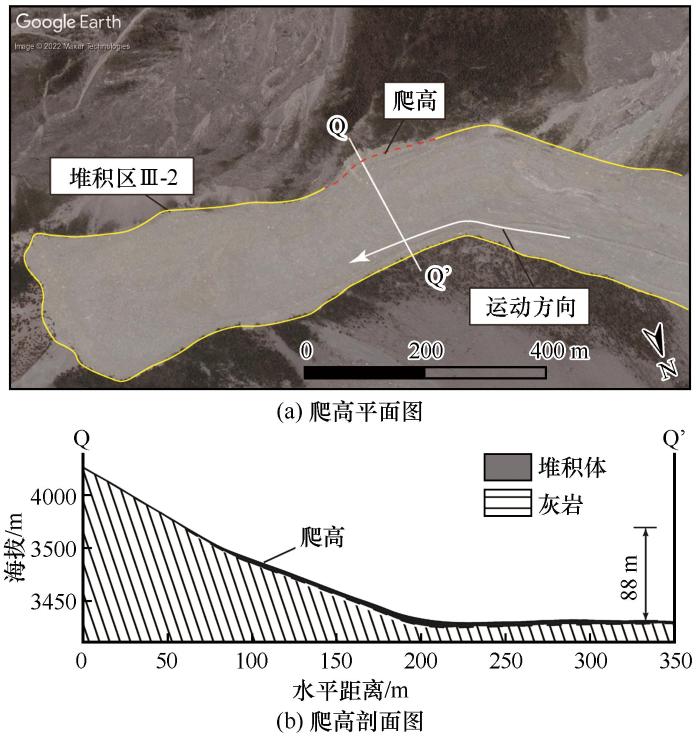
... 其次,干河坝冰-岩碎屑流在运动过程中经历了多次转向,其运动至谷形转折处(据前缘约910 m)时在南侧斜坡形成88 m的爬高(图10 ).根据爬高计算公式(1) [61 ] ,估计碎屑流在此处的运动速度高达29.9 m·s-1 .而根据峡谷转折后堆积体两侧沿根部倾倒的树木可知,滑坡物质运动到此处(距前缘约710 m)时速度已相对较小.据胡晓波等[62 ] 的研究,滑坡前缘在沟道地形偏转位置运动方向发生变化,会导致运动速度突降,造成动能耗散.因此,堆积区沟道偏转地形使滑坡减速变得更加剧烈. ...
Influence of channel deflection on the movement of a flowing landslide
1
2019
... 其次,干河坝冰-岩碎屑流在运动过程中经历了多次转向,其运动至谷形转折处(据前缘约910 m)时在南侧斜坡形成88 m的爬高(图10 ).根据爬高计算公式(1) [61 ] ,估计碎屑流在此处的运动速度高达29.9 m·s-1 .而根据峡谷转折后堆积体两侧沿根部倾倒的树木可知,滑坡物质运动到此处(距前缘约710 m)时速度已相对较小.据胡晓波等[62 ] 的研究,滑坡前缘在沟道地形偏转位置运动方向发生变化,会导致运动速度突降,造成动能耗散.因此,堆积区沟道偏转地形使滑坡减速变得更加剧烈. ...
沟道偏转地形对滑坡碎屑流运动的影响研究
1
2019
... 其次,干河坝冰-岩碎屑流在运动过程中经历了多次转向,其运动至谷形转折处(据前缘约910 m)时在南侧斜坡形成88 m的爬高(图10 ).根据爬高计算公式(1) [61 ] ,估计碎屑流在此处的运动速度高达29.9 m·s-1 .而根据峡谷转折后堆积体两侧沿根部倾倒的树木可知,滑坡物质运动到此处(距前缘约710 m)时速度已相对较小.据胡晓波等[62 ] 的研究,滑坡前缘在沟道地形偏转位置运动方向发生变化,会导致运动速度突降,造成动能耗散.因此,堆积区沟道偏转地形使滑坡减速变得更加剧烈. ...
Fractal fragmentation of rocks within sturzstroms: insight derived from physical experiments within the ETH geotechnical drum centrifuge
1
2010
... 与碰撞破碎阶段的运动形式不同,本文认为干河坝冰-岩碎屑流在堆积区以剪切运动模式为主.堆积区Ⅲ-2剖面中可观察到局部灰岩块石存在水平定向排列现象,这说明碎屑流在堆积区Ⅲ-2运动过程中滑体内部扰动性较弱,主要以水平层流运动为主.堆积区Ⅲ-2前缘被部分埋藏于地表以下的巨石及独特的“乘船石”结构也表明了滑坡体扩展变薄的运动过程.除此外,根据第3节滑坡前后遥感影像的解译可知,滑坡前流通区平台覆盖有冰雪物质且堆积区内冰融水十分丰富.通过实地考察发现堆积区广泛分布有“冰川乳坑”和冰雪融水.根据Imre等[63 ] 的研究,当基底摩擦较小时,碎屑流内部物质不容易发生破碎,其破碎能量消耗也较少.因此,本文推测失稳岩体在流通区裹挟有冰雪物质,且堆积区的饱和冰水沉积物导致堆积体基底摩擦较小.干河坝冰-岩碎屑流在底部冰水沉积物的作用下主要发生整体性剪切作用,颗粒间破碎作用并不显著. ...


 甘公网安备 62010202000676号